All Activity
- Past hour
-

December 2025 Short/Medium Range Forecast Thread
John1122 replied to John1122's topic in Tennessee Valley
Ironically, the GFS ensembles agrees with the Euro in general, and not with it's OP. -
December 2025 Short/Medium Range Forecast Thread
John1122 replied to John1122's topic in Tennessee Valley
It would be hard to be more different than the GFS is vs the Euro in the long range. The GFS is full torch, the Euro is full freezer. -

Nov 28-30th Post Turkey Day Wintry Potential
homedis replied to Chicago Storm's topic in Lakes/Ohio Valley
Looking good. Curious to see how the lake will affect snow ratios in lakeside areas with the slightly onshore SSE flow, but thinking 1:10 average is reasonable. Final call 7.5” Lake Forest, I’ll be stationed here for duration of the storm. They got around 6” from the LES event a few weeks back so that would be over a foot total for Nov — quite impressive. -
Euro is a N&W event similar to map above.
-

Nov 28-30th Post Turkey Day Wintry Potential
migratingwx replied to Chicago Storm's topic in Lakes/Ohio Valley
-
Nov 28-30th Post Turkey Day Wintry Potential
michaelmantis replied to Chicago Storm's topic in Lakes/Ohio Valley
For the first storm of the season, coming out of a bad 2024-2025, all the signs seem to be good for IA, S WI, and N IL. -

Nov 28-30th Post Turkey Day Wintry Potential
hawkeye_wx replied to Chicago Storm's topic in Lakes/Ohio Valley
00z Euro... This is about as locked into 8+" as my area ever gets.
-

Nov 28-30th Post Turkey Day Wintry Potential
Radtechwxman replied to Chicago Storm's topic in Lakes/Ohio Valley
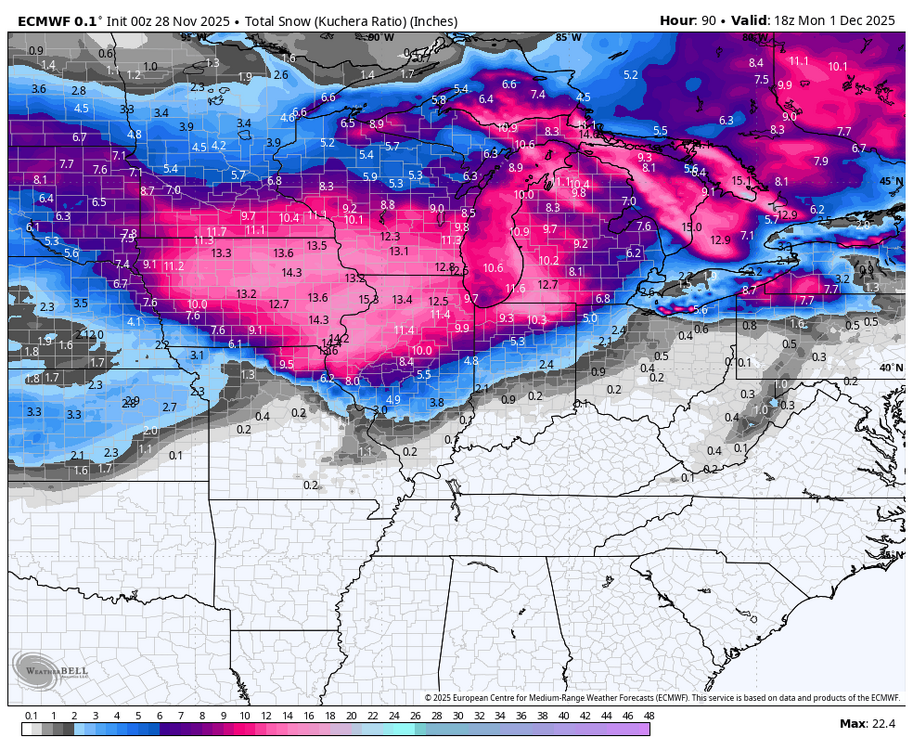
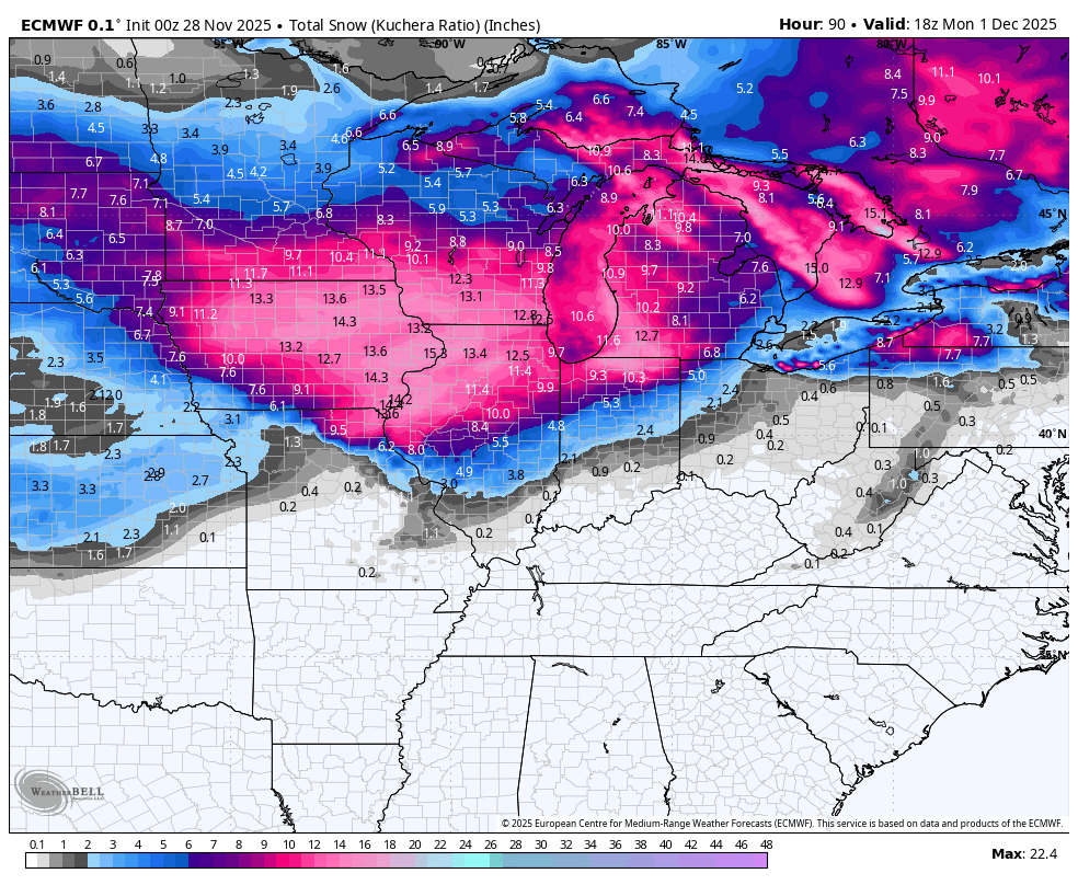
Something that should probably be used for this event in a lot of areas is snow depth to see a more realistic depiction of what you may measure on ground. Kuchera and 10:1 maps aren't accounting for the compaction and melting from this very wet snow that will likely occur and are probably overinflated. Yes 8-10in may fall but may not reflect on ground after melting and compaction. -
.thumb.png.ec4a32b8d2c4423ed890799cbdf9af95.png)
-
That high running off Maine just as it starts is no good for 12/2. Further west by 350 miles is needed
-
Winter is a different animal, Rainers are pretty easy.
- Today
-
The 0z UKMET and 18Z ECM-AI squash the shortwave and yield very little precip. At 4.5 days out this possibility is still plausible.
-
Orange Warning - Snow Squall Issued: 11:42 PM Nov. 27, 2025 – Environment and Climate Change Canada Hazardous snow squalls expected through Saturday. What: Extremely hazardous travel conditions. Total snowfall amounts of 40 to 70 cm with locally higher amounts possible. Near zero visibility at times in heavy snow and local blowing snow. Intense snowfall rates of 5 to 10 cm per hour at times. Strong winds gusting to 70 to 80 km/h. When: Continuing into Saturday. The heaviest snowfall is expected tonight into Friday. Additional information: This will be a long duration event with snow squalls likely persisting into Saturday, particularly near Lake Huron. Strong westerly winds gusting as high as 70 km/h are also expected. These strong winds will reduce visibility to near zero at times in local blowing snow. ### Road closures are possible. Please continue to monitor alerts and forecasts issued by Environment Canada. I won't be getting those totals this go around, but south if that monster band stays there maybe. Kitchener and Hamilton still under it! Barrie also getting lacerated.
-

Nov 28-30th Post Turkey Day Wintry Potential
Kaner88 replied to Chicago Storm's topic in Lakes/Ohio Valley
00z AIFS Op will be wetter in northern IL, upping total QPF above 0.75" compared to sub-0.75" the prior runs -
Just noticed that there are still pretty big differences between the CMC and GFS days 4-5 at 500mb. The CMC actually doesn't look too bad aloft... that's a borderline snowstorm to pretty close N&W. The GFS upper levels look like they would support more rain and less snow than depicted. I feel like the GFS will end up more right... hope I'm wrong.
-
It's difficult to know how significant it is that the GFS op is significantly wetter and further west compared to the GEFS mean. The GEPS and EPS are also a bit southeast and drier. Obviously the averaging-effect decreases the mean precipitation the more you go out in forecast time. But the majority of the individual ensemble members are also well east of the GFS. The op also appears to be a bit faster than ensemble consensus... maybe in response to the sharp Great Lakes shortwave/vortmax that is at the leading edge of the trof. I suspect the op (maybe higher resolution?) is more accurately resolving the shortwave progression than the ensembles. I expect the ensembles to play catchup, and I don't think we're done trending yet.
-

December 2025 regional war/obs/disco thread
PhiEaglesfan712 replied to Torch Tiger's topic in New England
How much snow for EWR on Tuesday? -

December 2025 regional war/obs/disco thread
Torch Tiger replied to Torch Tiger's topic in New England
NNE
-
i would wait to call 12/2-3 dead until the nov 30 storm happens. 36 hours out from then and there's still lots discrepancy between models. indy doesn't know whether they're going to get 8 inches of snow or just plain rain rn
-
Ukie is a light event, but I didn't bother to look how it got there.
.thumb.png.4812fe0f095c28815ba44e6261abb376.png)
-
We're back to: it's over.
-

December 2025 regional war/obs/disco thread
WxWatcher007 replied to Torch Tiger's topic in New England
It was solid for tropical season but there were big misses too. Obviously a different season we’re tracking now so we’ll see. -

December 2025 regional war/obs/disco thread
CT Valley Snowman replied to Torch Tiger's topic in New England
I'm not crazy with the trend with the high placement and strength.on some of the modeling. Definitely makes it more challenging for those of us further south as the warmer air aloft surges northward. We're threading the needle as we want a more dynamic system vs a weak shredded POS but with a track and high placement that will help keep the cold air in place longer. -

Nov 28-30th Post Turkey Day Wintry Potential
sbnwx85 replied to Chicago Storm's topic in Lakes/Ohio Valley
HRRR/RAP dry slot me but put down 11” of snow before that happens. That’s probably overdone. Final call: 9” -
The surface features aren't driving this outcome. The position and strength of the surface highs and lows follow the upper levels. The trend over the past 2 days is for the shortwave to not "dig" as far south. The vortmax that passes through the Great Lakes is becoming increasingly prominent. The path of this shortwave and vorticity advection ends up tracking pretty similarly to Sunday's wave that precedes it. That leads to a stronger surface reflection (primary) near Western PA and southeasterly low level flow that quickly changes snow to rain along the coastal plain. The hope is that maybe guidance is keying on the wrong packet of vorticity and that the models will shift back towards a more favorable trof evolution. As of now this is transitioning towards a SWFE-type event that favors the interior, particularly New England. But it's still close to a wintry outcome... and highly trackable.

.png.925d9e550832cdcd5566898281816b64.png)


.png.cbda9aba5c3ec516af82028ddfdf16b6.png)
