All Activity
- Past hour
-
That almost sounds like the perfect yardwork weather in summer Sent from my SM-G970U1 using Tapatalk
-
I'll pay for a mister to be installed on your roof.
-
91 / 79 and full sun (again). Near 80F dewpoints for days on end and not a drop of rain.
-
Thank you for sacrificing
-
A few hundredths with a lot of nearby downpours
-
Flood Watch National Weather Service Baltimore MD/Washington DC 1137 AM EDT Sun Jul 13 2025 DCZ001-MDZ003>006-011-013-014-016-501>510-VAZ025>031-036>040-050-051- 053>057-501>508-526-527-WVZ050>053-055-501>506-132345- /O.NEW.KLWX.FA.A.0025.250713T1600Z-250714T0600Z/ /00000.0.ER.000000T0000Z.000000T0000Z.000000T0000Z.OO/ District of Columbia-Washington-Frederick MD-Carroll-Northern Baltimore-Southern Baltimore-Prince Georges-Anne Arundel-Charles- Extreme Western Allegany-Central and Eastern Allegany-Northwest Montgomery-Central and Southeast Montgomery-Northwest Howard- Central and Southeast Howard-Northwest Harford-Southeast Harford- Western Garrett-Eastern Garrett-Augusta-Rockingham-Shenandoah- Frederick VA-Page-Warren-Clarke-Nelson-Albemarle-Greene-Madison- Rappahannock-Orange-Culpeper-Fairfax-Arlington/Falls Church/Alexandria-Stafford-Spotsylvania-King George-Northern Fauquier-Southern Fauquier-Western Highland-Eastern Highland- Western Loudoun-Eastern Loudoun-Northern Virginia Blue Ridge- Central Virginia Blue Ridge-Northwest Prince William-Central and Southeast Prince William/Manassas/Manassas Park-Hampshire-Morgan- Berkeley-Jefferson-Hardy-Western Grant-Eastern Grant-Western Mineral-Eastern Mineral-Western Pendleton-Eastern Pendleton- 1137 AM EDT Sun Jul 13 2025 ...FLOOD WATCH IN EFFECT THROUGH LATE TONIGHT... * WHAT...Flash flooding caused by excessive rainfall is possible. * WHERE...The District of Columbia, and portions of Maryland, including the following areas, Anne Arundel, Carroll, Central and Eastern Allegany, Central and Southeast Howard, Central and Southeast Montgomery, Charles, Eastern Garrett, Extreme Western Allegany, Frederick MD, Northern Baltimore, Northwest Harford, Northwest Howard, Northwest Montgomery, Prince Georges, Southeast Harford, Southern Baltimore, Washington and Western Garrett, Virginia, including the following areas, Albemarle, Arlington/Falls Church/Alexandria, Augusta, Central Virginia Blue Ridge, Central and Southeast Prince William/Manassas/Manassas Park, Clarke, Culpeper, Eastern Highland, Eastern Loudoun, Fairfax, Frederick VA, Greene, King George, Madison, Nelson, Northern Fauquier, Northern Virginia Blue Ridge, Northwest Prince William, Orange, Page, Rappahannock, Rockingham, Shenandoah, Southern Fauquier, Spotsylvania, Stafford, Warren, Western Highland and Western Loudoun, and West Virginia, including the following areas, Berkeley, Eastern Grant, Eastern Mineral, Eastern Pendleton, Hampshire, Hardy, Jefferson, Morgan, Western Grant, Western Mineral and Western Pendleton. * WHEN...Through 2 AM tonight. * IMPACTS...Excessive runoff may result in flooding of rivers, creeks, streams, and other low-lying and flood-prone locations. * ADDITIONAL DETAILS... - Showers and thunderstorms will form this afternoon and linger on and off through the first half of the night. Storms will be slow moving and capable of producing very heavy rainfall. Rainfall totals of 1 to 2 inches appear likely for locations that receive thunderstorms, with isolated totals of 2 to 4 inches. The strongest thunderstorms may be capable of producing 1.5 to 2.5 inches of rain in an hour. - Please visit www.weather.gov/safety/flood for flood safety and preparedness information
-
I can't recall a summer that had this many situations where storms didn't move. Flash Flood Warnings are almost a daily occurrence. 0.02" from 2 hours of continuous drizzle.
-

July 2025 Obs/Disco ... possible historic month for heat
dendrite replied to Typhoon Tip's topic in New England
Maybe the 1656hr one will verify -
July 2025 Obs/Disco ... possible historic month for heat
dendrite replied to Typhoon Tip's topic in New England

-

July 2025 Obs/Disco ... possible historic month for heat
DavisStraight replied to Typhoon Tip's topic in New England
He got a double bogey with a 3 putt -
Heavy downpour produced a quick .6 inches. I’m over 9 inches of rain now total since June 1st in Alexandria/Mount Vernon.
-

July 2025 Discussion-OBS - seasonable summer variability
wdrag replied to wdrag's topic in New York City Metro
No thread yet, but considering on for I95 corridor northwest across NNJ and se NYS for iso 5" in 3-6 hours Mon afternoon-Night. Will review more guidance late in the day and repost around 8P. 12z/13 SPC HREF is more or less mirroring the heavier GFS qpf. Am pretty sure the iso ~ 5" occurs but where?. -

July 2025 Discussion-OBS - seasonable summer variability
BxEngine replied to wdrag's topic in New York City Metro
Wyoming and Montana was one of the most incredible trips of my life. -
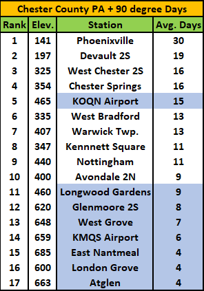
Below is an analysis of the average number of 90 plus days here in Chester County. You will notice how important elevation is to the number of such days. Elevations above 460 feet average 15.3 days over 90 degrees while locations below 460 feet (blue highlighted stations) average only 7.1 days in the summer.
-

E PA/NJ/DE Summer 2025 Obs/Discussion
ChescoWx replied to Hurricane Agnes's topic in Philadelphia Region
Below is an analysis of the average number of 90 plus days here in Chester County. You will notice how important elevation is to the number of such days. Elevations above 460 feet average 15.3 days over 90 degrees while locations below 460 feet (blue highlighted stations) average only 7.1 days in the summer.
-
E PA/NJ/DE Summer 2025 Obs/Discussion
ChescoWx replied to Hurricane Agnes's topic in Philadelphia Region
Today looks like a perfect beach day...but I have a family event down in Wildwood which will not involve the beach. Have an awesome day!! -

July 2025 Discussion-OBS - seasonable summer variability
nycwinter replied to wdrag's topic in New York City Metro
but dewpoints would be lower then they are in nyc during this humid stretch.. -
One of the greatest scenes from one of the greatest movies Sent from my SM-G970U1 using Tapatalk
-
I bet your garden is quite wormy Sent from my SM-G970U1 using Tapatalk
-
The old 20 min yard work window Sent from my SM-G970U1 using Tapatalk
-

Occasional Thoughts on Climate Change
donsutherland1 replied to donsutherland1's topic in Climate Change
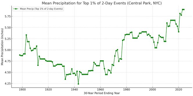
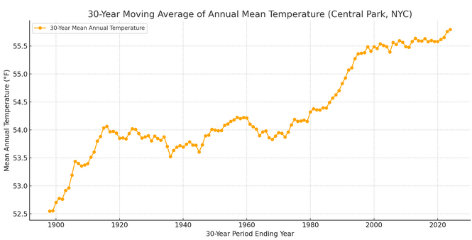
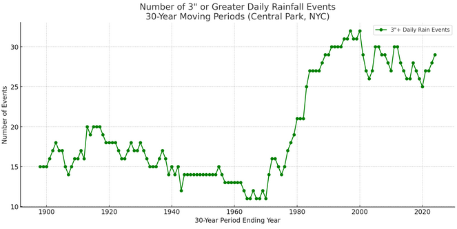
For illustrative purposes, I ran the numbers for New York City's Central Park (long climate record that goes back to 1869) to examine the connection between temperature and extreme rainfall events. Here are New York City's extreme rainfall events (top 1%) over one day and two days (overlapping two-day events are not double counted; the higher two-day rainfall is retained while the lower one is dropped, as the focus is on extreme events): Mean 30-Year Moving Average Temperature: The Clausius-Clapeyron Equation suggests that the atmosphere holds approximately 7% more water vapor for each 1°C increase in temperature. Therefore, one would expect a meaningful coefficient of determination between temperature and extreme rainfall amounts. That's exactly what one finds. The coefficient of determination between temperature and the top 1% daily rainfall events is 0.47. For the top 1% 2-day events, it is 0.48. That means that temperature explains 47% and 48% of such events respectively with warmer temperatures translating into more frequent and/or intense extreme rainfall events (this analysis dealt with intensity of events). That's almost half of the outcome for such events. It is also what one would expect from the basic physics expressed through the Clausius-Clapeyron Equation. What about the frequency of extreme events (measured here as daily precipitation of 3" or more): The coefficient of determination is much higher. It is 0.67. That means temperature explains two-thirds of the change/frequency in daily extreme precipitation events. Additional factors involved in the frequency and intensity of such events include, but are not limited to ENSO, teleconnections, storm tracks, local/mesoscale dynamics, and land-use effects. Nevertheless, temperature, alone, is a major variable. Any arguments made over Social Media that the warming climate plays virtually no role in the observed increase in extreme precipitation events (intensity and frequency) have no scientific merit. Not surprisingly, repeated attribution studies have found a direct connection to climate change where such events become more frequent and more intense, again consistent with the basic physics.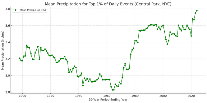
-

July 2025 Obs/Disco ... possible historic month for heat
Damage In Tolland replied to Typhoon Tip's topic in New England
Not gonna be much sum today. These are pretty locked in -
Hopefully EC doesn’t get overwhelmed. Up here, I’m surrounded but still not more than spittle imby. Based on how slow everything is moving, I’m okay with the miss so far.
-
Radar blowing up along 95 and other parts of Hoco. I see a lot of wet coming my way.
-

July 2025 Obs/Disco ... possible historic month for heat
ma blizzard replied to Typhoon Tip's topic in New England
poor guy has never been the same since a dark and stormy night in the chelmsford feeder lot


