All Activity
- Past hour
-
I would bet on the following winter being way better. I would much rather roll the dice with a La Niña, even a strong one than this super Nino bullshit. I like it when Canada is frigid.
-
 viagra without prescription [url=https://getbelvion.com/#]Get Belvion[/url] cheapest viagra
 -

Mid-Long Range Discussion 2026
WinstonSalemArlington replied to BooneWX's topic in Southeastern States
Change is coming -
п»їcialis generic: MenOn36 - cialis for sale
-
Picked up .14" from an early afternoon cell but nothing after. High of 97 at 2:14pm, low of 72 at 7:38am. July temps, not mid-September.
-

Septorcher 2026 Discussion - Endless Summer
powderfreak replied to Damage In Tolland's topic in New England
10/10
-

Fall 2026 Medium/Long Range Pattern Thread
dwagner88 replied to John1122's topic in Tennessee Valley
The record streak of consecutive 90+ degree days is going to top 50. We hit 100 again today, breaking a 130 year old record. -

Septorcher 2026 Discussion - Endless Summer
TauntonBlizzard2013 replied to Damage In Tolland's topic in New England
We tried to tell em. -

Septorcher 2026 Discussion - Endless Summer
ineedsnow replied to Damage In Tolland's topic in New England
18z Euro was about to go wild -

2026 Atlantic Hurricane Season
vortex95 replied to Stormchaserchuck1's topic in Tropical Headquarters
I am not sure AI models would do well for systems in this part of the Atlantic since TCs are not nearly as common as in other parts of the Atlantic. -

Septorcher 2026 Discussion - Endless Summer
WxWatcher007 replied to Damage In Tolland's topic in New England
It’s the perfect football Sunday. -
2026 Atlantic Hurricane Season
vortex95 replied to Stormchaserchuck1's topic in Tropical Headquarters
Edouard was named a TS at 00z 9/1. So it depends on what type of time you use if it formed in Sep or not! And if you go by when it was declared a TC, that is in August solidly. - Today
-

2026-2027 Record-breaking El Nino
40/70 Benchmark replied to Stormchaserchuck1's topic in Weather Forecasting and Discussion
Completely agree, which is why my preliminary assessment of the extra tropical Pacific holds it near neutral. -
Today's Highs: PHL: 87 New Brnswck: 86 ACY: 85 EWR: 84 BLM: 84 JFK: 83 TTN: 83 TEB: 82 LGA: 81 NYC: 80 ISP: 80
-

Septorcher 2026 Discussion - Endless Summer
VivaManchVegas replied to Damage In Tolland's topic in New England
a crappy sunday in the fall makes me feel better about my self when I watch 3 hrs of football. -
cheapest viagra or Sildenafil 100mg price Viagra online price https://www.google.co.bw/url?q=https://getbelvion.shop viagra without prescription or http://dnp-malinovka.ru/user/qwcchpentl/?um_action=edit Sildenafil 100mg price [url=https://www.google.ba/url?q=https://getbelvion.shop]Cheap Viagra 100mg[/url] viagra canada or [url=http://www.xunlong.tv/en/orangepibbsen/home.php?mod=space&uid=7006758]sildenafil 50 mg price[/url] viagra canada
-
Google Deep Mind
-
2026 Atlantic Hurricane Season
vortex95 replied to Stormchaserchuck1's topic in Tropical Headquarters
If was close to land, odds are they would declare it a TD as well. I do not agree w/ such a policy. Treat all systems the same regardless of location or risk in terms of calling it for what it actually is. One could call this a TD taking a snapshot as it is right now, but I go back to the persistence factor of convection and the marginal environment. -

Septorcher 2026 Discussion - Endless Summer
kdxken replied to Damage In Tolland's topic in New England
Torch! -
2026 Atlantic Hurricane Season
vortex95 replied to Stormchaserchuck1's topic in Tropical Headquarters
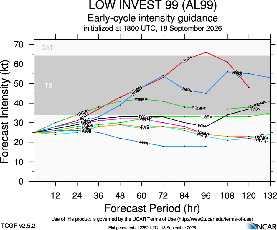
No I hadn't . What model is this? I was looking at the various primarily model outputs for intensity fcst (see attachment). The operational GFS and ECMWF do very little w/ the system. ECMWF brings it down to 1012 mb and makes it a TD. Since the overall environment is marginal and fcst to gradually degrade, I am not optimistic at this time more than a TD. That being said, the convection that has developed on the N side in the last few hours is more organized, but we need to see if it persists. The dry air present makes it prone to pulsing up and down. This makes it hard to pull the trigger and declare. At 03z, it could look quite good and get declared, and then all the convection could collapse, and we are back at square one. So NHC tends to hold off until clear trend or consistency exists. These kind of high-latitude systems are often a challenge!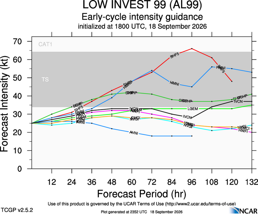
-
Order Viagra 50 mg online: Get Belvion - buy Viagra over the counter
- Yesterday
-
2026 Atlantic Hurricane Season
vortex95 replied to Stormchaserchuck1's topic in Tropical Headquarters
Great questions and critical thinking above. That's the right thing to in practicing good science -- asks lots of questions! See this paper 2011 paper (pdf attached): On the Classification of Extreme Atlantic Hurricanes Utilizing Mid-Twentieth-Century Monitoring Capabilities* A methodology is created to determine how many of these 10 recent Category 5 hurricanes likely would have been recorded as Category 5 if they had occurred during this period using only the observations that likely would have been available with existing technology and observational networks. Late-1940s and early- 1950s best-track intensities are determined for the entire lifetime of these 10 recent Category 5 hurricanes. It is found that likely only 2 of these 10—both Category 5 landfalling hurricanes—would have been recorded as Category 5 hurricanes if they had occurred during the late-1940s period. The results suggest that intensity estimates for extreme tropical cyclones prior to the satellite era are unreliable for trend and variability analysis. So it virtually certain due to limitations of tech, esp. prior to the satellite era, many cat 4s even some cat 3s documented were actually cat 5s. The hurricane reanalysis project has found solid evidence of cat 5sifor some system, and that has been corrected in HURDAT, but due to the mesoscale nature or the inner cores of these beasts, you just can't tell many times. Also, hurricanes do not remain at cat 5 strength very long, so that makes them even harder to detect historically. Even today, some are missed in the absence of recon since Dvorak estimates work best for systems 60 to 105 kt. This means two things. One, many TDs are actually weak TSs and two, many intense HUs are underestimated. There is very little difference on satellite what a strong cat 4 and a minimal Cat 5 looks like, and Dvorak cannot account for storm size, RMW, environmental pres gradient, storm forward motions, and other factors that go into actual wind speed of a TC. As an example, take HU Patrica from 2015. If not for recon, it likely would have been capped at 160 kt. I have yet to see NHC assign a HU in their AOR above 160 kt in the absence of recon or other in situ data. Even JTWC rarely goes above 160 kt. Patricia was rather small, and Dvorak does not do well for small TCs (underestimates). Now we did have recon, and initial obs were 175 kt. when it was 880 mb. However, the next recon, over 6 hr later, and it found 879 mb, but the satellite signature had weakened a bit, so recon missed Patricia’s absolute peak intensity. They gave Patricia and estimated 872 mb pressure, but it could have been lower. And on post-season analysis, the found Patricia peak winds were actually 185 kt! So you see how tricky and elusive these beasts can be, even when recon is available! I know Patricia was a cat 5 all along, but see the margin of error there w/ in actual in situ obs? The first official cat 5 in the Atlantic is not until 1924. Does that mean there were none prior? Of course not, just it was very hard to get actual obs to verify something that intense the further you go back, An unfortunate ship would have to survive getting into the core of these things or a land station would have to be at the just the right location and the instruments survive to verify a cat 5. Also, GFS dropsondes were not put into used until 1998, and the SFMR not until 2004. These were game changers as to recons to get a much better idea of the winds sfc and aloft in a TC. They way they got sfc winds prior? They would take about 90% of the FL (700 mb) winds, and go w/ that that. That works often, but not all the time. It can vary quite a bit as GPS dropsondes and the SFMR have shown! So really, using data prior to the 1990s for overall trends in intense hurricanes is not an apples to apples comparison. Our detection and documentation, technology, and knowledge/understanding has improved immensely in the last 30 years alone, giving us a much better idea of reality for TCs, esp. for the intense ones! And 30 years is too short of period to determine TC trends, esp. the in Atlantic since the AMO cycles are approx 25-45 years in length. And the idea that hurricanes are getting stronger overall? That notion is partially artificial b/c of the above. Non-wx/climate factors play a big role here. We are better than ever in observing and measuring the wx, getting better all the time, so we have been seeing things in recent decades due to better tech that were always there, just not able to be detected prior (go back to how the first cat 5 in the Atlantic is not until 1924). And the odds of seeing more absolute extremed and setting new records go up b/c of this tech factor as well. jcliD1100420 4461..4475 - hagen-landsea-jclimate-2012.pdf -

2026-2027 Record-breaking El Nino
GaWx replied to Stormchaserchuck1's topic in Weather Forecasting and Discussion
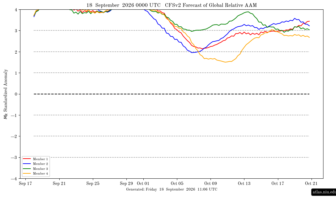
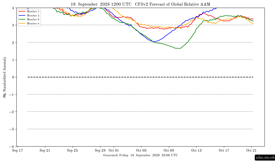
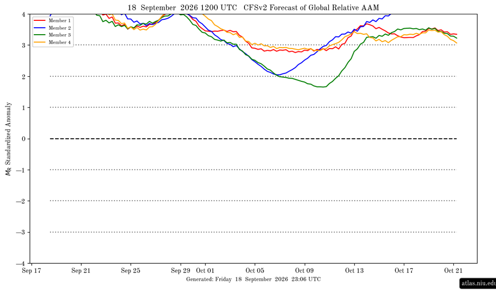
AAM +3.9 & rising to very extreme levels. Should be off the chart on next runs: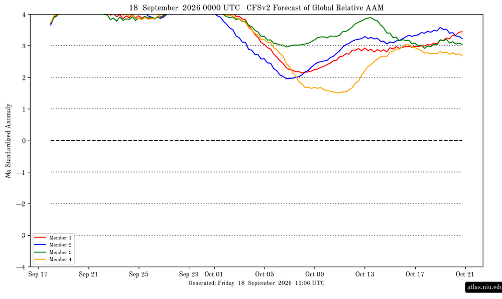
-

2026 Atlantic Hurricane Season
NorthHillsWx replied to Stormchaserchuck1's topic in Tropical Headquarters
If this was worth flying a plane into they’d called is a TD -
Last winter was good. Best winter in over 10 years.