All Activity
- Past hour
-
Yesterday’s 5.74” at Milwaukee was its second highest daily amount on record. Six of the top ten daily rainfalls have occurred since 2000. Records go back to 1871.
-
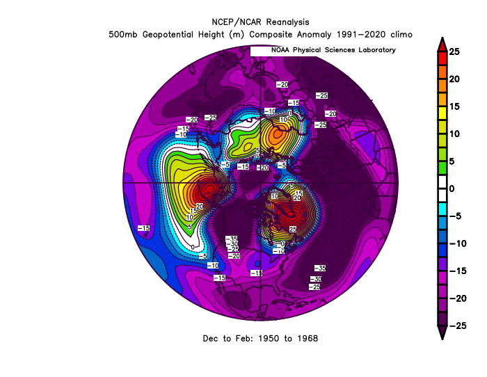
It’s possible that the strongest polar blocking since the 2007 Arctic sea ice decline has been back closer to the Barents and Kara seas due to the open waters in those locations during the winter. Maybe the Arctic winter pattern from 2007-2025 has been some type of open water SST feedback ridge where there used to be thick ice during the winter. The older blocking intervals used to have the blocking focused closer to Greenland. The last 18 winters have had the blocking centered from the KB areas to the pole instead. So this could be making the blocking more AO dominant instead of NAO focused.
-

2025 Spring/Summer Mountain Thread
Maggie Valley Steve replied to Maggie Valley Steve's topic in Southeastern States
Woke up to 59 here in the Valley. Amazing streak! -

E PA/NJ/DE Summer 2025 Obs/Discussion
Hurricane Agnes replied to Hurricane Agnes's topic in Philadelphia Region
Bottomed out at 62 this morning and am currently at my high for the day so far at 83, with dp 64. Guess we should enjoy before the next heat wave hits. AP had an article today about there being record humidity east of the Rockies so far this season based on EU's Copernicus (home of the EC) data - https://apnews.com/article/humid-muggy-sticky-climate-oppressive-summer-df1b506a3036a6ea0c4c8ad5bbd87429 Philly topped the list! -

2025-2026 ENSO
40/70 Benchmark replied to 40/70 Benchmark's topic in Weather Forecasting and Discussion
It's the dispersing of geomagnetic particles via solar wind that is the real trigger for +NAO, and that lags solar max. -
2025-2026 ENSO
40/70 Benchmark replied to 40/70 Benchmark's topic in Weather Forecasting and Discussion
Yea, it's somewhat nebulous, but the best consensus from the research that I reviewed is that the height of the tendency for +NAO coincides with geomagnetic peak, about 2 years post max and lasts until +4 years.....so 2-4 years post max. However, certainly +NAO is still somewhat favored right now. -
https://cwfis.cfs.nrcan.gc.ca/interactive-map Really helpful map for anyone planning trips, especially to remote areas.
-
Holy shit LibertyBell. You have this entire thread for you. Use it!
-
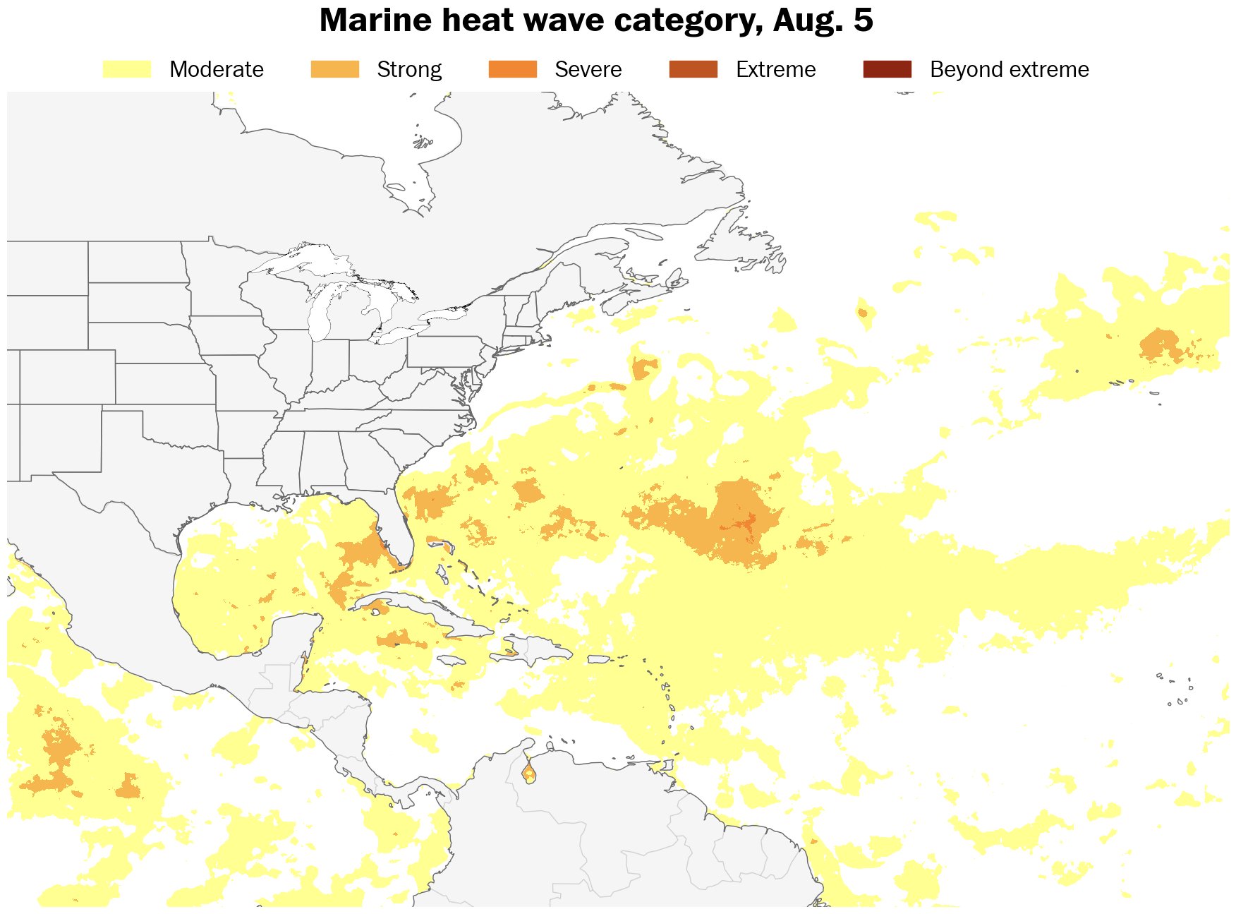
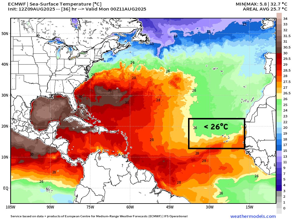
Look at these water temps, wow !
-
Impressive Western Atlantic warmth presently.

-

2025-2026 ENSO
Stormchaserchuck1 replied to 40/70 Benchmark's topic in Weather Forecasting and Discussion
I think it's strongest 0 to +4 years. -
NHC Special Weather Statement: NWS National Hurricane Center Miami FL 935 AM EDT Sun Aug 10 2025 For the North Atlantic...Caribbean Sea and the Gulf of America: Special outlook issued to update discussion of the disturbance located southeast of the Cabo Verde Islands (AL97). Eastern Tropical Atlantic (AL97): Updated: Recently received satellite-derived wind data indicate that a well-defined low pressure system has formed about midway between the west coast of Africa and the Cabo Verde Islands with maximum winds of about 35 mph. Although the associated shower and thunderstorm activity still lacks some organization, only a small increase in the organization could lead to the formation of a tropical depression before the low moves near or across the Cabo Verde Islands tonight and on Monday. Regardless of development, locally heavy rainfall and gusty winds are possible today and Monday across the Cabo Verde Islands, and interests there should monitor the progress of this system. Even if a tropical depression does not form over the next day or so, environmental conditions appear conducive for later development, and a tropical depression is likely to form by the middle to latter portion of this week while moving west-northwestward at 15 to 20 mph across the eastern and central tropical Atlantic. * Formation chance through 48 hours...medium...40 percent. * Formation chance through 7 days...high...80 percent.
-
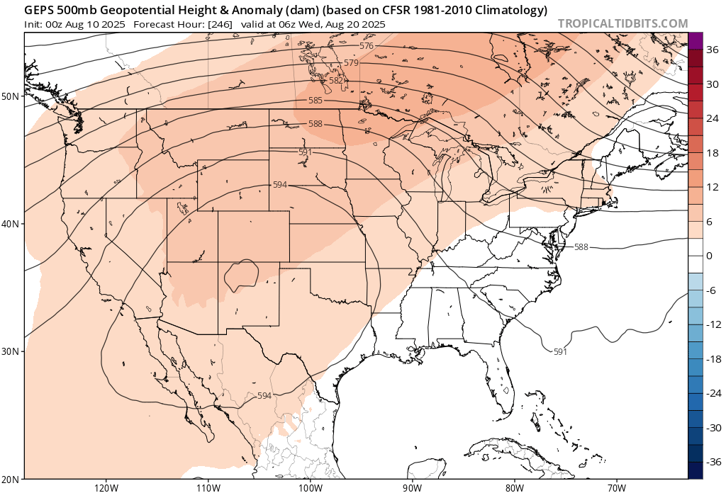
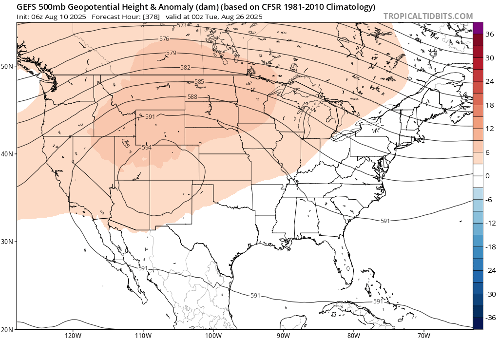
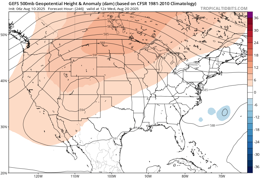
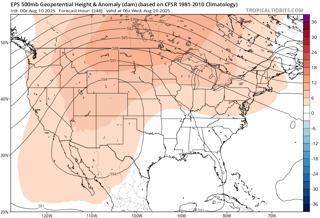
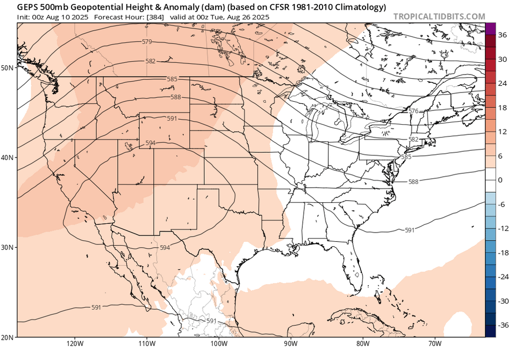
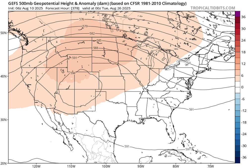
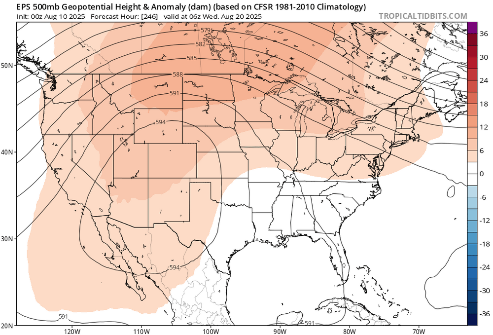
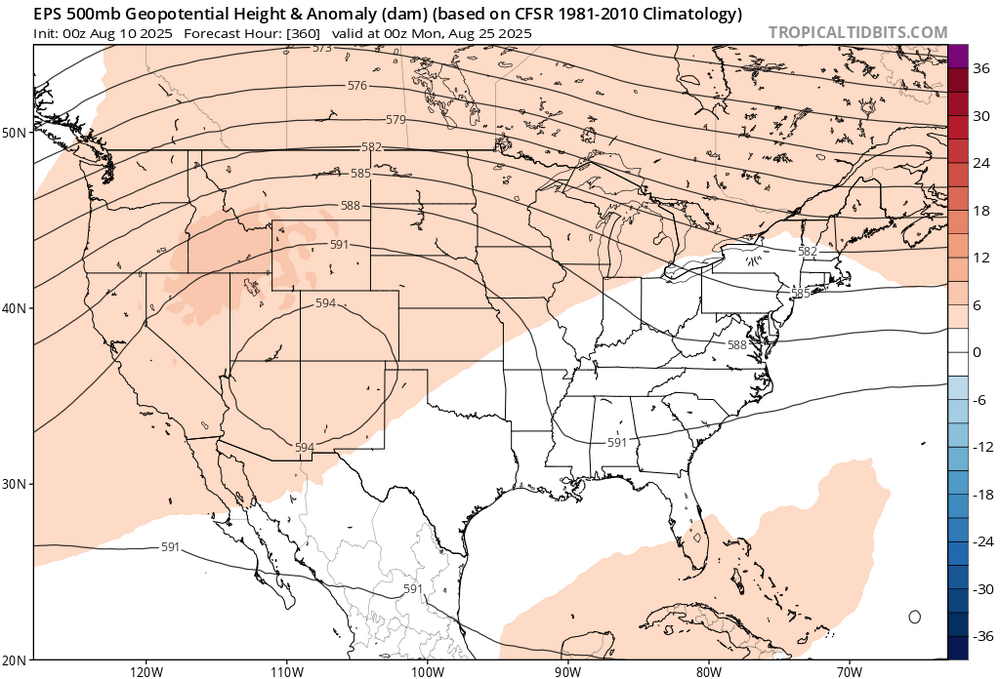
 It looks like the ridge sets up out west post day 10 and continues thru the end of the month. The up coming heat could be the last of the season.

-
The primary complaints have been with how they manage prospects, though...not sure why a good veteran free agent would see that and say "nah". I mean if we actually spend the money...I think they'll come. And actually, this team likes giving it's veterans playing time and we complain about starting them over the young players, lol As for CF is a little more tricky...Cowser is out with a concussion and I'd imagine even if Beavers were up he'd probably be playing in right.
-
So far, we’ve enjoyed a leisurely .7” here, south of Madison. However, it just started to REALLY dump on us…even my Starlink is struggling…so I think we’re finally going to actually get a good round.
-
I'm sure you'd love that, lol Kickers just seem to have stronger legs now, and 60 is slowly becoming the new 50!
-
2025-2026 ENSO
40/70 Benchmark replied to 40/70 Benchmark's topic in Weather Forecasting and Discussion
Well, it isn't 2+ years....solar max was last October. -
Beat me to it
-
It's still heat. I'm so over it and ready for Fall.
-
There’s going to be windshield wipers too on the ensembles.
-
iOS?
-
any luck? What phone or o/s?
-
The heat that's returning doesn't look like anything abnormal. For my area it looks like 87-92 for about 5 days before the low 80's return. I'm glad there's no sign of 98/78 type crap. I'll take no rain from now until my cannabis plants are ready to harvest in October lol
-
I would strongly advise against using telescoping hurricane models, such as HAFS, or the now depreciated HWRF model, until an actual system has formed. These models will key in on spurious or hallucinated rotation to “justify” kicking off the telescoped run, thus will almost always be extremely overdeveloped for nascent systems. Not saying it’s not right, but the odds are stacked against that run, especially for a depreciated model like HWRF