All Activity
- Past hour
-

Pittsburgh/Western PA WINTER ‘25/‘26
RitualOfTheTrout replied to Burghblizz's topic in Upstate New York/Pennsylvania
Yeah it was a long shot. Still may see a few mangled flakes but nothing interesting. At least the morning commute won't be a disaster. I think we all knew at some point in December this would flip, that's Nina climo to some degree and patterns break down in general. Question is what happens afterwards into January. Shame we couldn't keep the cold around one more week and instead it gets gross just in time for Christmas. -

December 2025 regional war/obs/disco thread
brooklynwx99 replied to Torch Tiger's topic in New England
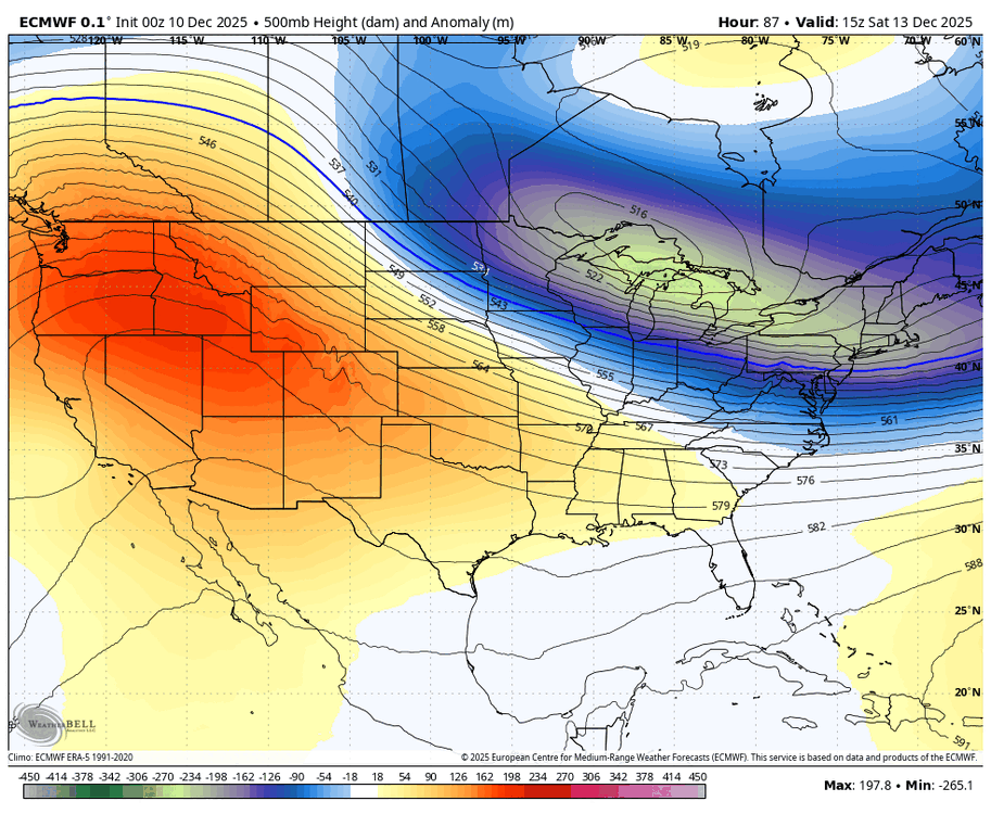
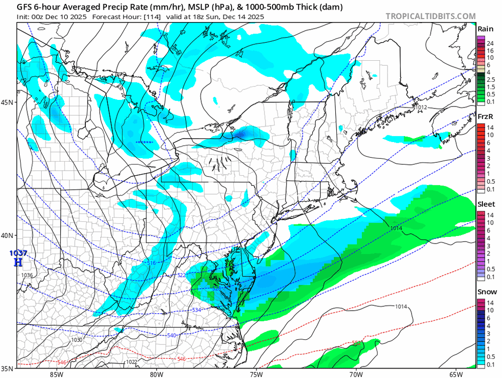
this is literally all it takes. slightly more lean westward with the TPV lobe -> higher downstream heights -> more buckling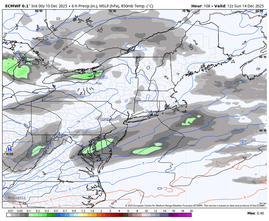
-
If the solution ends up verifying pretty close to the AI models, that would definitely be a big win for them. They’ve been way steadier than the regular OP runs.
-
hard to believe how cold its been and, yet we get rain later today here
-
So in other words its a miss
-

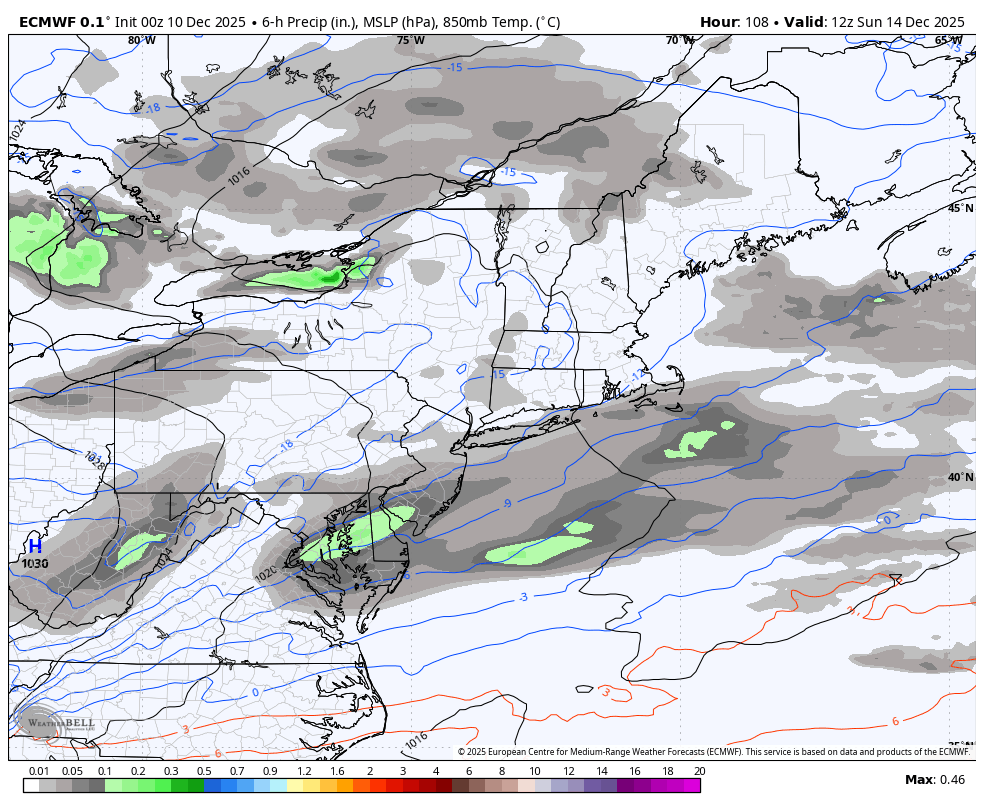
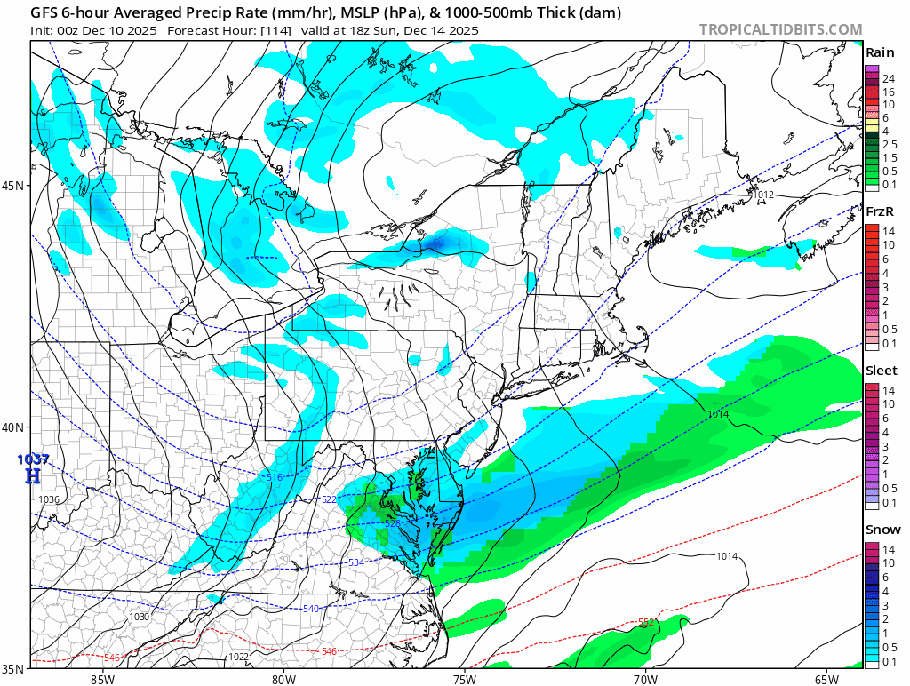
December 2025 Short/Medium Range Forecast Thread
Carvers Gap replied to John1122's topic in Tennessee Valley
This is the GFES ext from last night....this is its 35d map. -
I think this current climate regime just makes classic east coast storms very difficult. Flow is too fast, things don’t properly phase anymore, everything cuts inland or gets shredded, but south of I-70 can catch a break with these flat southern sliders (and sometimes even north central MD gets an occasional 3-5” event that 40N misses out on, but just not the elusive warning criteria storm). Trust me, north central MD is not the only place that’s been missing out.
-
December 2025 Short/Medium Range Forecast Thread
Carvers Gap replied to John1122's topic in Tennessee Valley
National Weather Service Morristown TN 611 AM EST Wed Dec 10 2025 ...New AVIATION... .KEY MESSAGES... Updated at 609 AM EST Wed Dec 10 2025 - Dry and warmer to start today, before a cold front arrival later tonight. Gusty winds ahead of the front for the forecast area. Wind Advisory in effect for all except the southern part of the forecast area. - NW flow snow event expected later today through early Thursday with accumulating snow over parts of the Southern Appalachians and higher terrain of southwest Virgina. A Winter Weather Advisory has been issued. - We will warm up again late week with low chances of precipitation across the north. - Stronger cold front Sunday into Monday will considerably drop temperatures. Lows in the teens with some single digits Monday morning. Cold wind chills also possible. && .DISCUSSION... Issued at 1138 PM EST Tue Dec 9 2025 The forecast for today has come into better agreement over Wind Advisory level winds for everywhere north of the southern valley and southern plateau later today. As well as an accumulating snow event for northwest flow prone locations of the forecast area; Southern Appalachians and parts of southwest Virginia. Temperatures will be warmer today, however, cloud cover will be on the rise. Almost advisory level winds are being observed at Cove Mountain with gusts in the upper 30s at the time of this discussion. A WSW LLJ will increase into the overnight hours, bringing increasing winds to the higher terrain. Later in the day as mixing occurs, the gusty conditions will translate to the surface for the lower elevations, hence the advisory covering the day-time. A heavier weighted blend of the HREF/RRFS was used to capture the usually overperforming SWly winds for the valley. Gusty winds will continue into Thursday morning for the higher terrain, slowly decreasing behind the FROPA. A Wind Advisory is in effect later this morning first beginning in the mountains, expanding to the lower elevations, later finishing for the mountains early tomorrow. Confidence has also increased on higher snowfall amounts for the higher terrain with the latest guidance. The day will start warm, but temperatures will fall coinciding with the cold front later this evening. Rain will transition to a rain/snow mix, and then eventually all snow for elevations primarily above 2500 feet. Low-level moisture, NW winds, and temperatures below freezing are evident on forecast soundings, all supporting northwest flow snow. Snow will end early to mid Thursday when low-level winds drop off and lose the NWly component. Total snowfall accumulations will generally be 1 to 3 inches with higher mountain tops possibly seeing above that, for example, LeConte may see up to 5 inches. It`s possible some light snowfall may be seen across lower elevations of the northern valley and plateau, but is generally not favorable with NWly flow due to more downsloping on the valley side, which means drier. A Winter Weather Advisory has been issued and will begin mid-day, running 24 hours highlighting the potential for the aforementioned areas. Following the snow`s exit Thursday, a short cool-down can be expected with drier conditions throughout the day and decreasing cloud cover. However, precipitation from a weak system will bring increased chances to northern parts of the CWA Friday. Meanwhile, upper heights will be rising which will bring the warmer temperatures back for Friday and Saturday. Later this weekend becomes a bit complicated in regards to more precipitation due to potential interaction of southern and northern stream systems, but the one thing models agree on, is a substantial drop in temperatures Sunday into early Monday. Strong high pressure is expected to barrel its way through, originating from Alaska and Western Canada, where temperatures there have been in the 50s below at night, but we will not see that here. Monday morning lows are currently forecast to be in the teens with some single digits for the highest elevations and parts of southwest Virginia. Wind appears will be on the decline once we get later in the night Sunday into Monday, which is good news and may suppress what could be much worse wind chills. High pressure will eventually shift eastward but will keep us dry through at least early Tuesday. -
December 2025 Short/Medium Range Forecast Thread
Carvers Gap replied to John1122's topic in Tennessee Valley
Sometimes when we look at weather in the d10-15, we miss the stuff right in front of us. Light snow is possible tonight across NE TN and SW VA(assuming that also means SE KY). Then, again on Friday w/ a slightly more "vigorous" system. WWAs have been hoisted for portions of those areas for tonight - mainly higher elevations. -
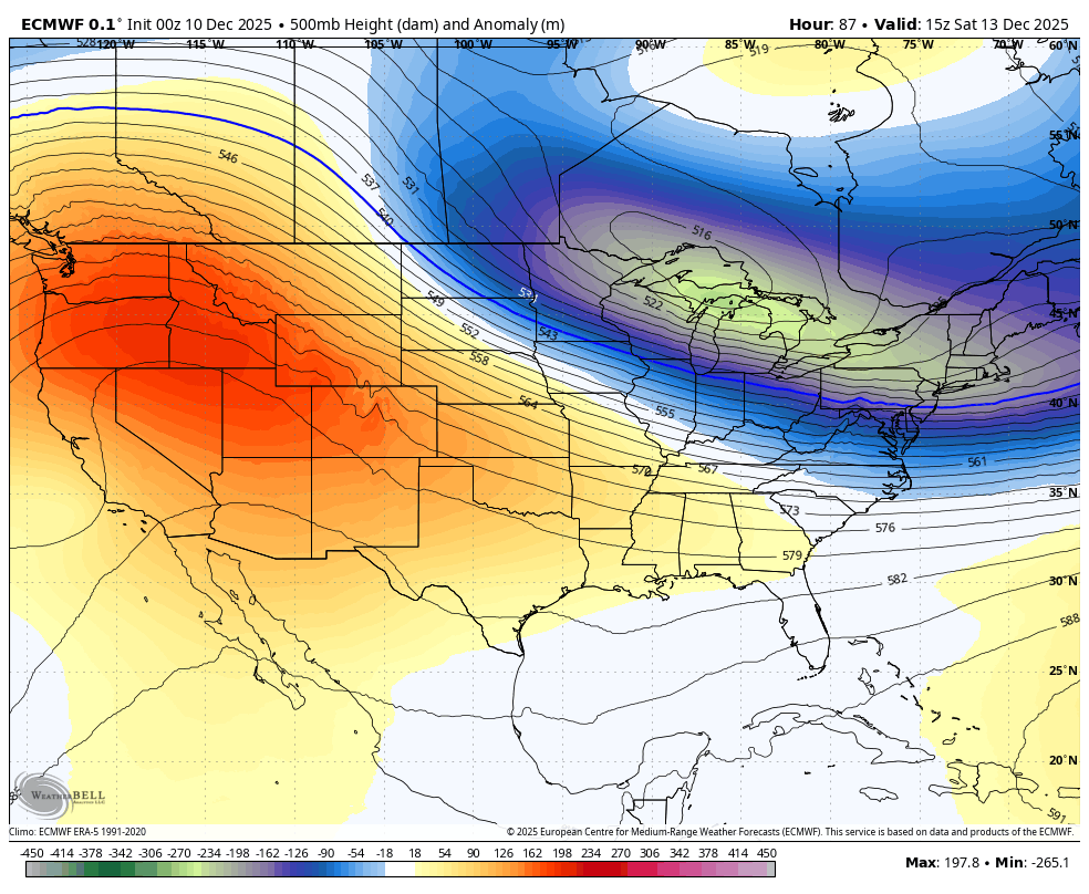
We haven’t had a December shoutout since 1895 when the first 15 days of the month were as cold as this year is going to be. Would be a new record for wasted December cold in the modern era. But nothing really surprises me anymore due to how extreme the Pacific Jet has become since 2018-2019.
-

December 2025 regional war/obs/disco thread
WinterWolf replied to Torch Tiger's topic in New England
That doesn’t look bad at all…been super steady with that look. Gonna be very interesting to see if they win this battle. -

Central PA Winter 25/26 Discussion and Obs
mahantango#1 replied to MAG5035's topic in Upstate New York/Pennsylvania
Hoping next summer features at least 2 weeks straight mid 90's with dp in mid 70's. -
Glorious!
-
-
December 2025 regional war/obs/disco thread
WinterWolf replied to Torch Tiger's topic in New England
Well there ya go…hate to say it, but the machines have been steady…if it materialized huge win for them. And take the other junk and throw em in the trash. If they fail, dump em all into the Liquid Metal pool. -

December 2025 regional war/obs/disco thread
moneypitmike replied to Torch Tiger's topic in New England
The heaviest set up south of route 1. Managed a little here on the fringe. About an inch so far. MEZ025>028-101400- Sagadahoc-Lincoln-Knox-Coastal Waldo- Including the cities of Arrowsic, Bath, Phippsburg, Bowdoinham, Topsham, Bowdoin, Whitefield, Jefferson, Dresden, Alna, Bremen, Bristol, Damariscotta, Newcastle, Boothbay Harbor, Wiscasset, Waldoboro, Owls Head, Rockland, Appleton, Camden, Hope, Rockport, Thomaston, Belfast, Northport, Searsmont, and Lincolnville 554 AM EST Wed Dec 10 2025 ...Area of Heavy Snowfall To Impact Morning Commute... An area of heavy snow has developed across portions of the Mid- Coast of ME. Webcam imagery indicates that roads are snow covered and visibility is reduced. Snowfall accumulations between 1-3" are likely for portions of the region with locally higher amounts -

Central PA Winter 25/26 Discussion and Obs
Voyager replied to MAG5035's topic in Upstate New York/Pennsylvania
Yeah, I know. As has been mentioned at times in this, and other forums, it seems that lately any modeled warm ups get muted over time. -

December 2025 regional war/obs/disco thread
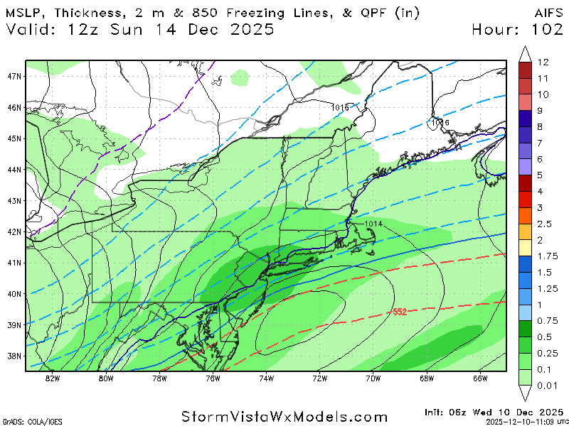
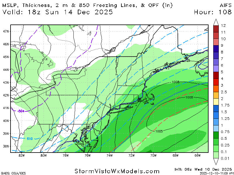
SouthCoastMA replied to Torch Tiger's topic in New England
6z Euro AI was a good hit here, and likely a bit inland -
December 2025 regional war/obs/disco thread
SouthCoastMA replied to Torch Tiger's topic in New England
If the storm is real, models should start catching on soon without disappearing acts now that we approaching 96 hours -
December 2025 regional war/obs/disco thread
WinterWolf replied to Torch Tiger's topic in New England
Are the AI’s still bringing it? If so, that may be a flag to pump the breaks on the no storm idea. Cuz they’ve been steady with it as a system of interest. -
Definitely This is why the models are having a tough time. Flow is too fast . Hopefully the milder pattern isnt long and we go into an amplified pattern.
-
Gfs might be coming around
-
December 2025 regional war/obs/disco thread
WinterWolf replied to Torch Tiger's topic in New England
I’ve said this for a few years now…off hour runs are different. Folks made fun of that, but I think we are seeing this as a fact for sure. Why? -
I would worry about sun angle this weekend. .
-
Milder pattern is coming up. Hopefully it doesnt last long.