All Activity
- Past hour
-

“Cory’s in NYC! Let’s HECS!” Feb. 22-24 Disco
Go Kart Mozart replied to TheSnowman's topic in New England
Turkey dinner? -

Feb 22nd/23rd "There's no way..." Storm Thread
arlwx12 replied to Maestrobjwa's topic in Mid Atlantic
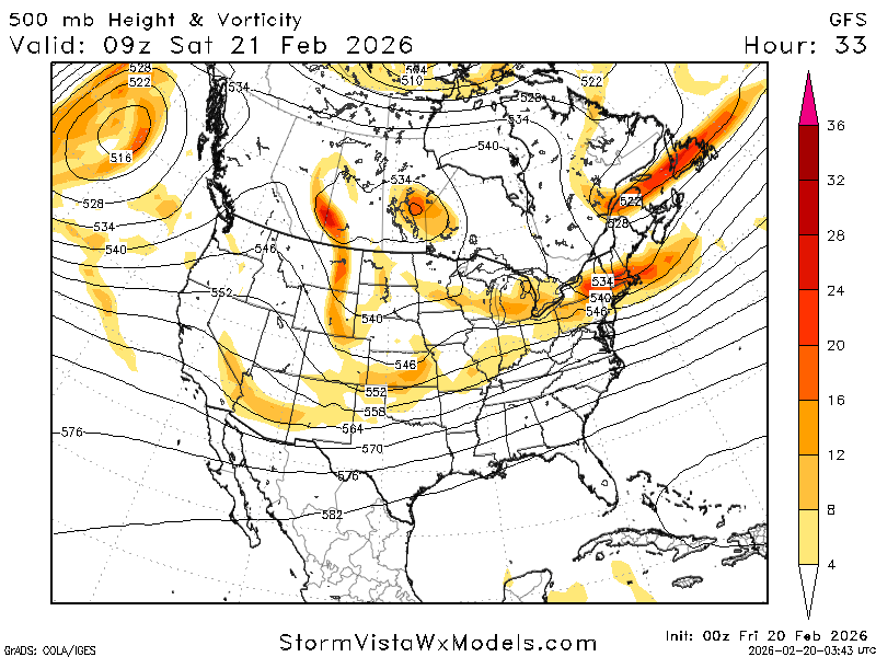
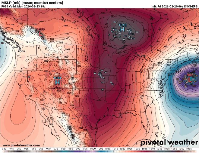
Slightly updated wording from LWX's AFD at 1029... If the upstream ridge-building event takes place a bit further west near 120 W longitude on Saturday, downstream trough amplification would be favorable for phasing over the mid MS Valley into the OH/TN Valleys Saturday night. A subsequent low track hugging the coast would become more likely in this scenario, aided by downstream blocking and a potential source of cold air given the upper lows over Maritime Canada and surface high pressure attempting to ridge into northern New England. There is also an appearance of an inverted trough signature in a subset of model guidance over the last couple cycles, given interaction between a more amplified northern stream wave and a bit more distant offshore southern stream low. This could factor into precipitation amounts and placement. After reviewing the 00z model guidance suite, some subtle consistency has been noted although subtle uncertainty remains. Most of the models has a low tracking up from GA/AL toward the NC coast and off the Delmarva coast during the late Saturday night into late Sunday timeframe. The question remains in the proximity toward the coast along with cold air availability, and the overall scope of the precip shield pending the placement/intensity of the system. 25 to 50 miles could make a huge difference between seeing little to no wintry precip or impactful precip, especially for those east of the mountains where the confidence remains low due to thermal issues especially below elevations of 1500 feet. The 00z GFS/GEFS solutions have come down a tad, but still produce measurements on the order of 10+" of snow over a large chunk of the area. Meanwhile, the 12z EPS ensembles came up some, but at much more conservative levels which align with deterministic runs of the NAM, RDPS, GDPS, GEM, CMC, EURO/EURO AIFS, and UKMET. The latest NBM also came up a bit and aligns with the majority compared to the GFS/GEFS outliers, especially along and east of I-95. With that said, the 6/12z model suites should put the remaining puzzle pieces together as we will sit 60 hours from the event. Three scenarios remain: 1) The phase of all of these upper level features occurs too late, with low development offshore and too far southeast. 2) Similar to scenario 1, but an inverted trough on the back side of the low brings snow to eastern portions of the region. 3) Low develops closer to shore and strengthens along Delmarva Peninsula, resulting in the most snow for our areas. We still remain in the "wait and see" period with this storm, so just take precautions now, should the worst case scenario play out. Having a preparedness kit stocked up is never a bad idea. Lastly, no matter what plays out further east, it seems much more likely that the mountains will see another round of upslope snow. The key here will be with how much we manage to get. That will depend on the storm track as well, but it seems much more likely for at least advisory to perhaps warning level accumulations through the Sunday/Monday period along/west of the Allegheny Front. Of note, the higher sun angle later in the season becomes a factor especially for lower elevations if precip occurs during the day. Cold air will also be filtering into the region as the storm in question approaches, rather than being locked-in beforehand, which offers another layer of uncertainty in p-type. -
Yep as I said yesterday ( and I got weenied for it ) there is still plenty of time for this to continue to creep more N n W and I hope that it does ,,,,,,,less than 48 hours Let's Go !!!
-

“Cory’s in NYC! Let’s HECS!” Feb. 22-24 Disco
Kitz Craver replied to TheSnowman's topic in New England
Beep. Beep. Beep. Back that ass up -
@Newman can you give us a GFS PBP? Really appreciate all your analysis lately!
-
GFS is going for broke with that NS piece over MT. my god
-
Sugar
-
We will need this to go a bit more NNW, Ultimately, Track it thru the GOM but that i think is off the table
-

Feb 22nd/23rd "There's no way..." Storm Thread
TowsonWeather replied to Maestrobjwa's topic in Mid Atlantic
As subtle as they are, I would THINK they might bode well downstream? At least in theory. No point speculating, I guess, just too complex to say at this point. Could just as easily go sideways on us. -

“Cory’s in NYC! Let’s HECS!” Feb. 22-24 Disco
brooklynwx99 replied to TheSnowman's topic in New England
GFS is going for broke with that NS piece over MT. my god
-
The beauty of latitude. It may work against you Sunday though we shall see enjoy today.
-
Wind will prob keep ratios down especially along coastal areas
-
evaporative and dynamic cooling will be included!
-

“Cory’s in NYC! Let’s HECS!” Feb. 22-24 Disco
ineedsnow replied to TheSnowman's topic in New England
-
-
“Cory’s in NYC! Let’s HECS!” Feb. 22-24 Disco
Go Kart Mozart replied to TheSnowman's topic in New England
The mixed metaphor award! I love it! -
Picking up pretty quick here at the shop
-
If the storm verifies like gfs or close there would probably also be some dynamic cooling to help with ratios no?
-
“Cory’s in NYC! Let’s HECS!” Feb. 22-24 Disco
J Paul Gordon replied to TheSnowman's topic in New England
SE Mass and Cape/Islands storm? Haven't been paying it too much attention. -

“Cory’s in NYC! Let’s HECS!” Feb. 22-24 Disco
Damage In Tolland replied to TheSnowman's topic in New England
Will this be powder inland ? -

Feb 22nd/23rd "There's no way..." Storm Thread
Terpeast replied to Maestrobjwa's topic in Mid Atlantic
Still changes with the SW canada shortwave on gfs even at hour 18 -
The problem with his hypothesis is that a number of models have trended toward the GFS solution, even if the 6z GFS proves to have been overdone. At shortening lead times and the shift in the guidance, it's difficult to argue that an increasing number of models are misinterpreting an IVT. Far more likely, the shift in the guidance suggests that his hypothesis concerning the GFS is incorrect, even if the GFS returns to its earlier solutions.
-

“Cory’s in NYC! Let’s HECS!” Feb. 22-24 Disco
Sey-Mour Snow replied to TheSnowman's topic in New England
This has easy 30" potential for SEMASS .. I'd be ecstatic if I was there, I'm hoping for sloppy seconds out here.. -
It always finds a way to snow in OC. As it stands now most guidance still gives us warning criteria snowfall
-

Southern MD / Lower Eastern Shore weather discussion
Lowershoresadness replied to PrinceFrederickWx's topic in Mid Atlantic
I remember when you started this thread. we had some great times

.thumb.png.991e09c19c25af7391ed569a205a5136.png)


