All Activity
- Past hour
-

Strong Nor'Easter/Hybrid Storm Late September 2026
Brian5671 replied to Rjay's topic in New York City Metro
would have turned to rain with the storm moving inland over NJ -

October Comes Early: Late September Multi-Hazard Hybrid Storm
jsw replied to WxWatcher007's topic in New England
Brattleboro, .10? Last hour it has been heavier off and on, so maybe .25 now. No rain gauge, going on KEEN totals. Not much in the way of wind. -

2026-2027 Record-breaking El Nino
40/70 Benchmark replied to Stormchaserchuck1's topic in Weather Forecasting and Discussion
Man, Cosgrove sounds aggressive....have 2014 a shoutout. -
Yup. Those are from last year that I picked up from a grower in Mass.
-
Dendrite is that from a grafted tree ? Those look just like the ones I’ve been eating.
-

October Comes Early: Late September Multi-Hazard Hybrid Storm
HIPPYVALLEY replied to WxWatcher007's topic in New England
Wow, you tripled up my totals. Not even .40” here. -
Looking forward to a nice 3 day return to summer. Could be our last 80 plus day?
-

2026-2027 Fall/Winter Mountain Thread
Maggie Valley Steve replied to BlueRidgeFolklore's topic in Southeastern States
Looks like our rain chances increase next weekend as moisture from Polo makes landfall on the Baja Peninsula spreads inland across Texas and combines with a strong Fall Cold Front and a surge of tropical moisture from the Gulf. Still a lot of details to iron out, but the potential is there for another heavy rainfall event followed by another push of cold air. Welcome to a strong El Nino Fall and Winter. This early September Nor'easter is a harbinger of things to come! -

Strong Nor'Easter/Hybrid Storm Late September 2026
winterwarlock replied to Rjay's topic in New York City Metro
1.27 2 day total imby -

Strong Nor'Easter/Hybrid Storm Late September 2026
nycwinter replied to Rjay's topic in New York City Metro
thank goodness this was not a winter storm all the people would be upset because we are in the dreaded dry slot.. -
 El Nino's are warmer Summers in Europe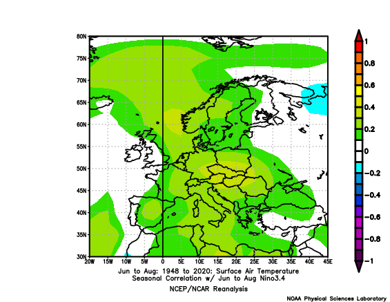
-
 thanks, we work hard all offseason for this. No days off
-

October Comes Early: Late September Multi-Hazard Hybrid Storm
CoastalWx replied to WxWatcher007's topic in New England
6z euro had another 4-5” on its run. Obviously a chunk of that happened already but still. -

Strong Nor'Easter/Hybrid Storm Late September 2026
nycsnow replied to Rjay's topic in New York City Metro
Surprised how strong winds still are, thought they’d be dying down by now -
October Comes Early: Late September Multi-Hazard Hybrid Storm
tavwtby replied to WxWatcher007's topic in New England
gauge at the house reading.63", and wife says nothing spectacular as far as wind, stations around my area saw maybe a few 30+ gusts, meh, it was legit windier on Wed before I left -
 indian online pharmacy: indian pharmacy delivery to usa - reputable indian pharmacies for otc drugs
 -
October Comes Early: Late September Multi-Hazard Hybrid Storm
EastonSN+ replied to WxWatcher007's topic in New England
Happy the power outages were not as many as expected. Did not lose any branches. -
Let's talk about the odds for a warm December for the CONUS Strongest east-based El Nino on record +QBO -PDO Chance of beating the 91-20 average warm nationwide is probably 75-80% just generally What's the odds, 90% Some La Nina/-QBO's had huge Aleutian blocks, which flexed the SE ridge.. Im thinking that's how it could bust cold, Pacific driven not NAO
-

Strong Nor'Easter/Hybrid Storm Late September 2026
Superstorm replied to Rjay's topic in New York City Metro
Might be able to get Yankees game in before rains. . -
.thumb.jpg.6a4895b2a43f87359e4e7d04a6fa0d14.jpg)
Central PA Autumn 2026
Yardstickgozinya replied to canderson's topic in Upstate New York/Pennsylvania
@Jns2183The new NESDIS web user interface absolutely sucks. -

2026-2027 Record-breaking El Nino
bluewave replied to Stormchaserchuck1's topic in Weather Forecasting and Discussion
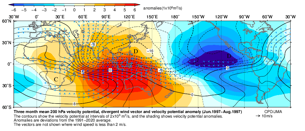
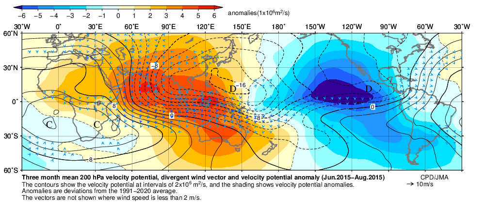
Yeah, this was the strongest east based forcing summer pattern on record. So the IO and Maritime Continent had more sinking air than 1997 and 2015. But since the ridging was so strong leading to warmer SSTs from Japan to south of the Aleutians, we got the more Niña-like summer -PDO pattern. This enhanced mid-latitude ridging extended across the CONUS to Europe going against the previous cooler summers during developing El Niño summers.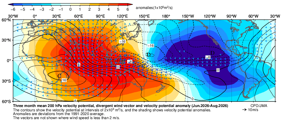
-
October Comes Early: Late September Multi-Hazard Hybrid Storm
CoastalWx replied to WxWatcher007's topic in New England
It’s just sheets of rain blowing sideways. Still windy. Impressive. -
Central PA Autumn 2026
Yardstickgozinya replied to canderson's topic in Upstate New York/Pennsylvania
It is very impressive. I was working on my geo satellite post but you beat me to it before I could get mine up. I ended up taking out my water vapor images. Looks really nice from some of the other channels too. -

October Comes Early: Late September Multi-Hazard Hybrid Storm
Brewbeer replied to WxWatcher007's topic in New England
lol hot take 58/57 and about as breezy as it ever gets in this wind hole -
medicine from india [url=https://geninduspharma.shop/#]reputable indian pharmacies[/url] rx india online shopping