All Activity
- Past hour
-

Hurricane Erin - 75 mph - 996 mb - WNW @ 18
audioguy3107 replied to BarryStantonGBP's topic in Tropical Headquarters
There is a lot of keyboard yelling. -

Hurricane Erin - 75 mph - 996 mb - WNW @ 18
wthrmn654 replied to BarryStantonGBP's topic in Tropical Headquarters
I'm sorry but does anyone know what staton is saying 90%of the time? -
Unlike the 0Z, the 12Z UKMET is back (similar to yesterday’s 12Z that I’m quoting) with a followup AEW to Erin becoming a TD at 162 and nearly to a TS at 168 just N of the Virgin Islands moving WNW. This looks like the same AEW that the 12Z GFS has but is ~500 miles further WNW than the GFS at 168, which is then only near 16N, 58W. This is the AEW causing the commotion in the SE US on the 6Z GEFS during 8/26-30: NEW TROPICAL CYCLONE FORECAST TO DEVELOP AFTER 162 HOURS FORECAST POSITION AT T+162 : 18.9N 62.8W LEAD CENTRAL MAXIMUM WIND VERIFYING TIME TIME POSITION PRESSURE (MB) SPEED (KNOTS) -------------- ---- -------- ------------- ------------- 1200UTC 22.08.2025 168 19.4N 64.7W 1005 33
-
Except Fiona! What a great chase that was.
-
Chronic ones at that. I’m sure it will be 80/60 on Halloween though.
-
With that HP there?
-

Occasional Thoughts on Climate Change
Typhoon Tip replied to donsutherland1's topic in Climate Change
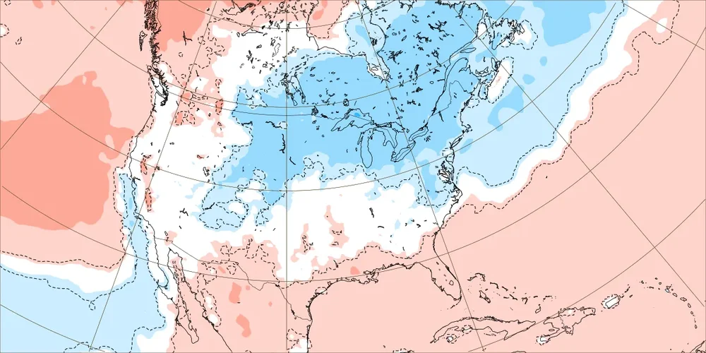
I also add to it... It's meteorological/anecdotal so the exact worth, be that as it may, but I've been observing over the last two decades what appears to be a positive/harmonic environmental/geological feed back mechanism that begins to physically exert ( non-linearity) a retrograding force wrt to the summer ridge positioning. When episodic continental, mid-latitude ridging balloons, it's not given a chance to get to non-Markovian ("quantom memory" favoring future states) aspects, because no sooner...within just shorter days it's already attempting to slip back W-SW under the jet and PHX steals the heat show. So what is the environmental/geological factor: As the western hemispheric winds begin to absorb the backward exertion of the flow, due to western N/A cordillera topography, the C-force turn the air right while is being forced to ascend over said topography. This generates a standing wave ridge like construct, which then couples/constructively interferes with the continental summer heat. Once set up, the thermal wind component than combines with C-force ... bending right, which further genesis' the anticyclonic field at large scales; the whole system tries to all but isolate itself because these factors fantastically compliment one another. Harmonic. This is a synergistic for both heat result, but also en masse physically enhances drying. Some years we end up with these "weakness" in the longer-termed geopotential layout E of 100W across the mid latitude continent. This ends up with murky humid daily downpour thunder over eastern America, with big heat in the west... Once or twice, a pattern break sufficiently strong enough may temporarily overcome these background aspects, and threaten to lower Pac N/W heights... -D(PNA) then dislodging the kinetically charged air from the SW ... but, the background tends to overwhelm and yank it back - so to speak. This year we've seen more -EPO/-PNA tandem than the last 5 years. We've also seen more >95 F days at climo sites spanning the OV/NE regions, too. But these murk years are not necessarily cooler years for the OV/NE regions. Nocturnal temperatures are often held up well above normal, such that the total dailies still average comparably large. But we're not talking us... haha Yeah, so there's some additional feedback that tries to sustain aridification that may not be specifically related to cold water along/off the West Coast, too. -
Interesting change of events on the weeklies for the last week of August starting on the 25th. Top map is from the 8/3 run, middle map is from last Friday, the 8th, and the bottom map is from yesterday. Could be fun if this kind of trend continues thru winter on the weeklies...or suck (for some) if it goes the other way.
-
 is the rise also slower for SNE (like places in CT near the shoreline) Chris? I was amazed that Bridgeport had a higher temperature than JFK the other day, I thought they were more vulnerable to the sea breeze there. When do you think 100 degree temperatures at JFK might start to happen more often, like they did in the 1940s and 1950s up to 1966 Chris?
 -
wow I'm really surprised 1995 ranks above 1993, 1993 had the more extreme heatwave and set the 90 degree record at NYC
-

Hurricane Erin - 75 mph - 996 mb - WNW @ 18
BarryStantonGBP replied to BarryStantonGBP's topic in Tropical Headquarters
-
Yeah that will rearrange some beaches, even without a landfall. I wonder if the models are keying in on some baroclinic fourcing. Wind field really expands so that would be the only way to maintain such ridiculously low pressures. (Obviously over modeled) Anything sub 940 north of 30 would be unprecedented in the modern era.
-
That's why I said "most." It’s never wall to wall cold early in the season or all through a cold winter. Even 1/96 had a heck of a warm spell. But I'm not even suggesting it will be a cold winter or that you need early cool shots for a cold winter. My point was more to suggest we may be able to lower the odds the cr@p, warm winters in light of the early season cool shots.
-
Not yet. Our shallow well's reserve is usually ~500 gallons (5 ft deep in the tubs). In 2001, our driest year here, it was below 300 and dropping, until late fall. CON is +4.8F on the highs and -1.1F on the mins. Yore heat Similar here: +5.5 and -0.8
-
gets it to 914
-

Hurricane Erin - 75 mph - 996 mb - WNW @ 18
Wannabehippie replied to BarryStantonGBP's topic in Tropical Headquarters
Erin trying to clear out the last of the dry air preventing it from some rapid intensification. http://blob:https://www.tropicaltidbits.com/aab02ef8-e81f-4556-8126-6b2fcb614b60 -
 Here are the standardized scores for Central Park. I used the same criteria as for JFK Airport.
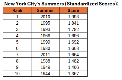
-
I'm missing jburns
-
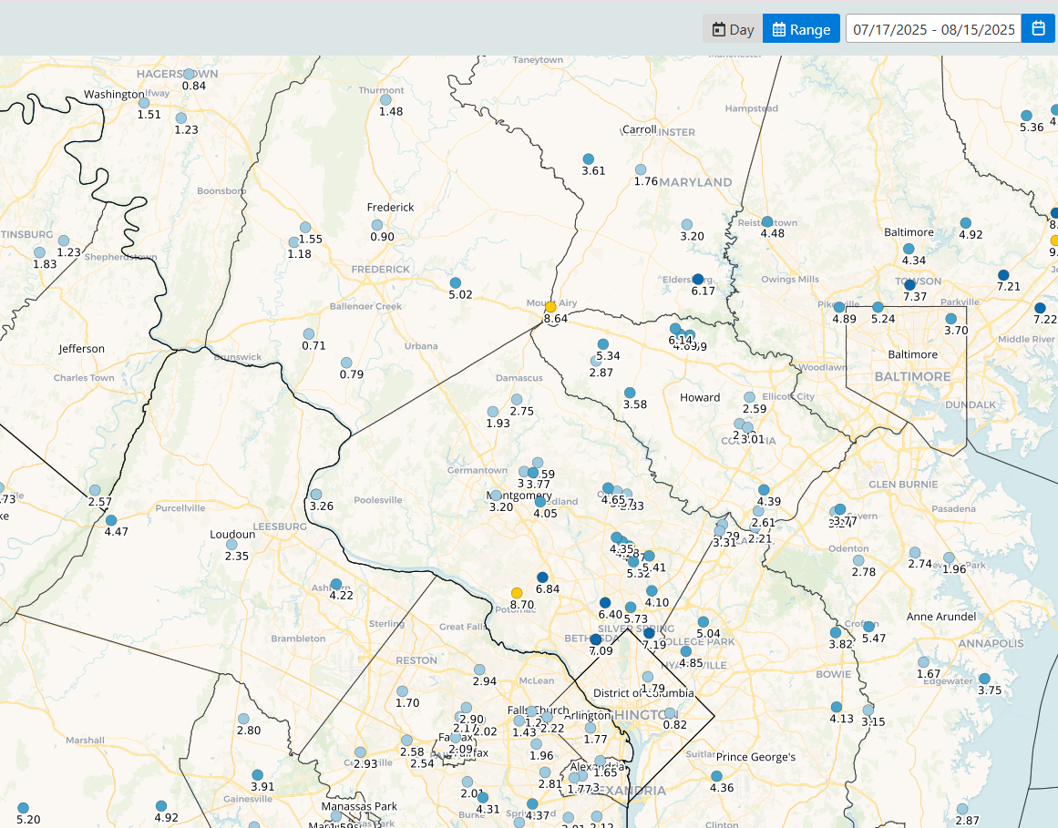
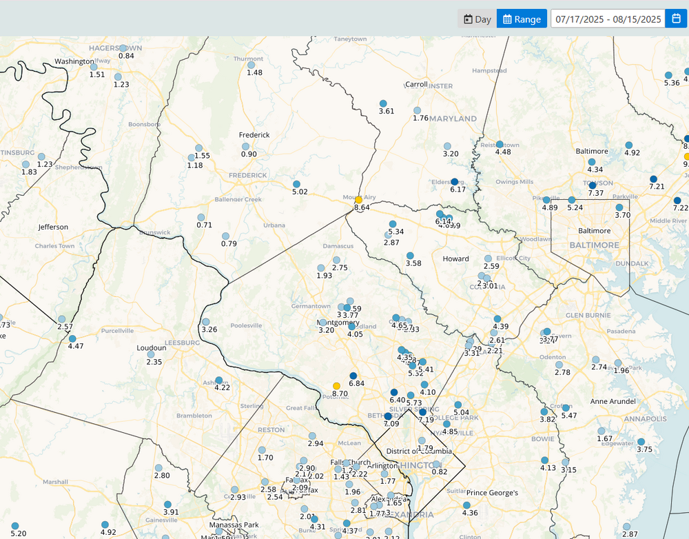
Only 0.02 for the month to date.... following a big July.. Grass looks the best its looked in a couple months though, brown moldy spots disappearing... Streams coming out of the southern National Park in both eastern Augusta and western Albemarle are running very low though - especially since its August and everything is still green/growing and using water...
-
1 For sure! The CoCoRaHS observations for the last 30 days. That's me with the 0.90" in Frederick. Your area looks well watered
-
It would, though.
-
2025 Atlantic Hurricane Season
BarryStantonGBP replied to BarryStantonGBP's topic in Tropical Headquarters
-
yeah.. it's interesting following these atmospheric indices as I do. Yesterday, an early autumn 'shot across the bow' type pattern was coherent in both the numerical data, but also in the synoptic/spatial layouts, from all three ens sources GGEM/GEFS/EPS. I posted about it... that's normal. If your goal is to not materialize a pattern you want, all you have to do is mention it. Boom! wanted pattern summarily breaks heart. This is why you should never tell a woman how you actually feel... No but since then the numerical side of that have pushed a new -PNA/-EPO tandem out there between D10 and 14. Then, the operational runs overnight sort of half committed; the Euro and GFS proper having some suggestion, which fits that tandem. We'll see. It's harder and harder anyway to determine that particular week any given season, when the season tries to pick up more than it can handle and cracks haha. Seriously, CC is seriously f*cking that orderly expression ( in time ) from happening as dependably as it did for grand pappy. We'll get a frost on Sept 10 and then 90 for 3 days on 15th... just sayn'
- Today
-
Hurricane Erin - 75 mph - 996 mb - WNW @ 18
BarryStantonGBP replied to BarryStantonGBP's topic in Tropical Headquarters
OI LADS GTFIH NOW I JUST SAW THIS WHILE IN SPOONS LASSIE EXPECTED TO BE A CATEGORY 4 FORECAST POSITIONS AND MAX WINDS INIT 15/1500Z 18.2N 56.1W 65 KT 75 MPH 12H 16/0000Z 18.9N 58.4W 75 KT 85 MPH 24H 16/1200Z 19.8N 61.4W 90 KT 105 MPH 36H 17/0000Z 20.6N 63.8W 105 KT 120 MPH 48H 17/1200Z 21.6N 66.0W 110 KT 125 MPH 60H 18/0000Z 22.7N 67.9W 115 KT 130 MPH 72H 18/1200Z 23.8N 69.2W 120 KT 140 MPH 96H 19/1200Z 26.5N 70.8W 115 KT 130 MPH 120H 20/1200Z 30.3N 71.0W 110 KT 125 MPH $$ Forecaster Beven -
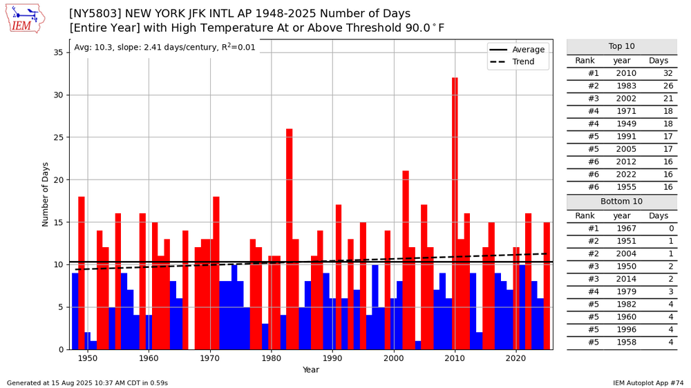
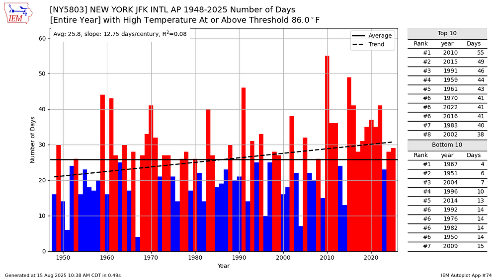
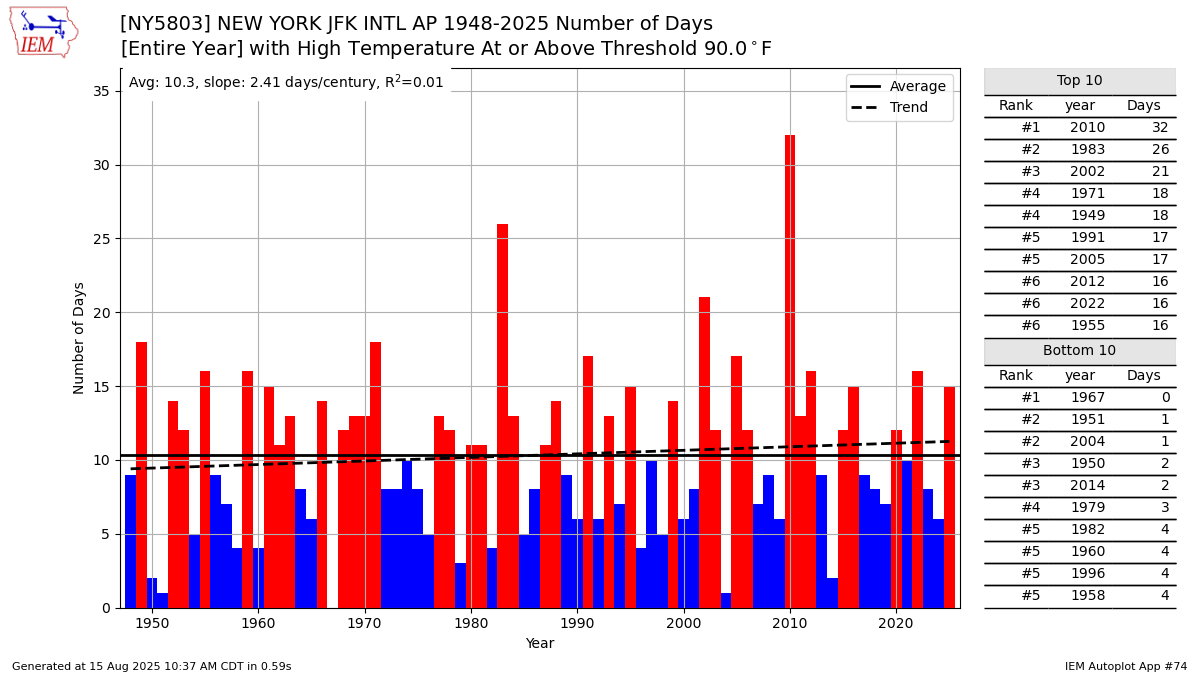
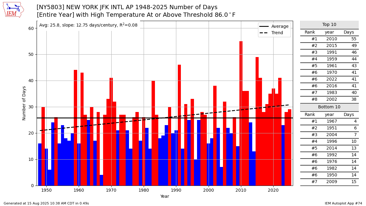
 90° days have been increasing at a slower rate than the 86° days at JFK. If the summer high temperatures rise another 2-4°, then the 90° days will begin to increase more sharply. The summer average high is still too low for a big increase in 90° days like areas west of the sea breeze in NJ have experienced.