All Activity
- Past hour
-
 Nice write up on the wind potential from OFK AFD: NEAR TERM /THROUGH TONIGHT/... ***Strong to High Winds Possible Tonight*** Deepening low pressure over the Great Lakes will track east today and pass to the north tonight, dragging a strong cold front through the area. Gusty SW winds will precede the front with the potential for gusts of 25 to 35 mph this afternoon, highest along the coast and east end of LI (40-50kt LLJ passing to the SE). A few showers will be possible along and ahead of the front this evening. CAMs show a line of convection approaching the Lower Hudson Valley around 8 pm (00Z), then dissipating as it works west to east across the area through around midnight. There is weak instability and an isolated thunderstorm is possible north and west of the NYC metro. SPC does have the Lower Hudson Valley and much of southern CT under a marginal risk, as an isolated thunderstorm could mix down some higher winds from aloft. However, the main concern is for a period of strong to possibly high post-frontal winds. The strongest winds look to be for about a 3- to 6-hour period following the cold frontal passage, from around midnight to daybreak. Latest 00Z soundings from NAM and GFS do show a period of 50-55kt winds at the top of the mixed layer during the strongest cold advection. At the same time, the nighttime hours are not as conducive to mixing due to the loss of daytime heating. NBM winds which are notoriously too weak in these situations have winds gusts below 45 mph, and even the NBM90 isn`t much higher. Neither of which support high wind warning criteria (sustained equal or greater than 40 mph and/or gusts equal or greater than 58 mph). In fact, the NBM probabilities are less than 10 percent for greater than 55 mph. Ever the HREF and global ensemble (GEFS,GEPS,and EPS) also have low probabilities. The highest probabilities are over the warmer water due to to the better mixing. Thus, have changed the high wind watch to a wind advisory for the Lower Hudson Valley, interior NE NJ, and interior SW CT. Elsewhere, the high wind watch remains in effect due to the maritime influence and warmer surface temperatures providing a deeper mixed layer. However, confidence is not high enough to go with a warning and there is time to get another look at some newer guidance before making a final decision. Either way, feel confident for gusts of 40 to 50 mph areawide.
 -

Overnight Wednesday, November 5, 2025 Wind Event
dendrite replied to weatherwiz's topic in New England
The first one you mentioned was over 20 years ago. I think you kinda proved my point. I want to say there was a good one in early 06 too…Feb maybe? -
 As others pointed out the models seem to be backing down and it should be an advisory event. A lot of leaves have already come off trees as well which will help limit damage potential.
 -
The Euro seasonal tends to have more skill for its summer forecasts than during the winters. We have had several recent summer forecasts that did OK. But it doesn’t really do too well with the winter forecasts. Probably just too many interacting variables during the winter to figure out. The EPS skill level falls off markedly between week 1 and week 2 at most points during the year. Occasionally, it does very well week 3 and beyond like the forecasts for March 2012. Last winter the EPS exhibited several biases which it also has over the years. First, it completely missed the mid to late December EPO reversal from the forecasts near the start of December. I was pointing out early on how the Pacific Jet was being underestimated which turned out to be correct. So it had to play catch up with the big jet extension in mid to late December which lead to the warm up and strong +EPO vortex. Our recent pattern of the warm up between December 17th and 25th worked out like every December since 2011. During February I was pointing out early on that it was probably underestimating the Southeast ridge which is another bias. So the heavy snowfall axis it was forecasting closer to NYC wound up further north than earlier in the month. Toronto would up to be the big winner as we got our first February Southeast ridge link up with a 5 sigma Greenland block.
-
Verbatim it looks like a classic canonical “front-loaded” La Niña progression
-
A bit of mixing at the Westminster mesonet site and the RH already tanking into the mid 30s. Might be a sneaky wildfire risk closer to the metros.
-

November 2025 general discussions and probable topic derailings ...
CoastalWx replied to Typhoon Tip's topic in New England
Yeah, I think that was 2008. There were tons of water spouts over Narragansett Bay. -
Overnight Wednesday, November 5, 2025 Wind Event
CoastalWx replied to weatherwiz's topic in New England
NAM was never really enthused which was a red flag. -
Overnight Wednesday, November 5, 2025 Wind Event
CoastalWx replied to weatherwiz's topic in New England
Nw flow deals are good inland too because usually it’s CAA winds mixing down. Yeah east can be better due to pressure gradient, but it’s better than banking on strong NE winds over the interior. -

Central PA Fall Discussions and Obs
mahantango#1 replied to ChescoWx's topic in Upstate New York/Pennsylvania
Just a tragedy in Louisville with a UPS plane crashing last evening. There are about 300 flights a day from this UPS facility. The plane went down about a half mile from where we were camping less than 6 weeks ago, where Louder Than Life Festival is held. And people were reporting after the crash there was debris found near and around where we were camping. Prayers for everyone impacted with this tragic event. -

Overnight Wednesday, November 5, 2025 Wind Event
bristolri_wx replied to weatherwiz's topic in New England
12z HRRR looks windier than the 0z but nothing over 50 forecasted... NAM 3k maxing out at 45... -

Overnight Wednesday, November 5, 2025 Wind Event
WinterWolf replied to weatherwiz's topic in New England
Aren’t You on the coastal plain?…windier there for the most part. So you do better most times. -
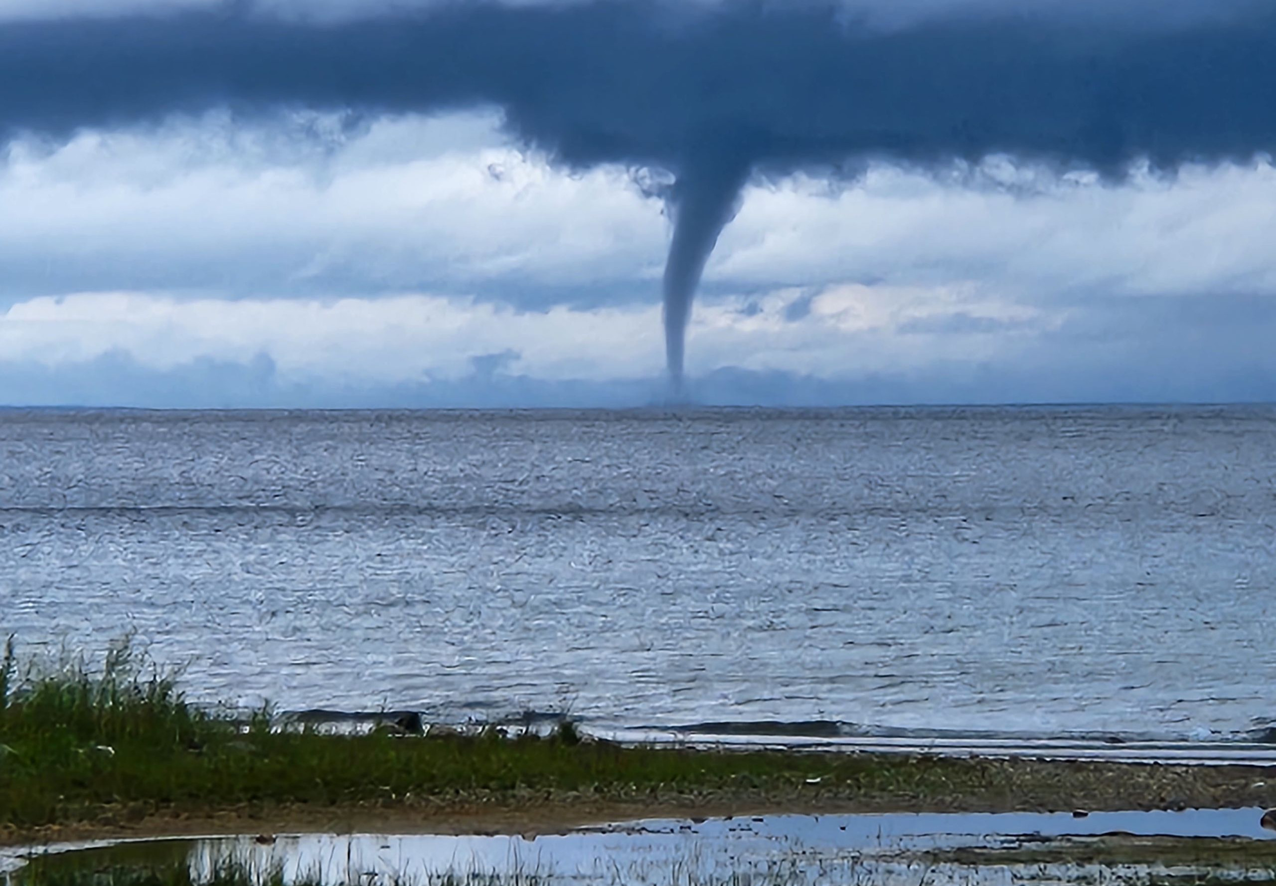
 I saw several of those one day fishing on Lake Ontario, I have the pics somewhere.
 -
Amen brother!!!!
-
Overnight Wednesday, November 5, 2025 Wind Event
CoastalWx replied to weatherwiz's topic in New England
We’ve had a few NW flow deals that I can recall that really did some damage. There was one I think in Nov 2004. Heck in Jan this year we had one after fropa that did damage here. -

November 2025 general discussions and probable topic derailings ...
jsw replied to Typhoon Tip's topic in New England
I think this is it.
-
Overnight Wednesday, November 5, 2025 Wind Event
WinterWolf replied to weatherwiz's topic in New England
I wouldn’t go that far Don. We do very high end coastal winter storms here. We were just due for a regression. And that’s exactly what we got. Those will be back. San Diego does nothing but blue skies and mild temps. So we are not quite them. -
(002).thumb.png.6e3d9d46bca5fe41aab7a74871dd8af8.png)
Central PA Fall Discussions and Obs
ChescoWx replied to ChescoWx's topic in Upstate New York/Pennsylvania
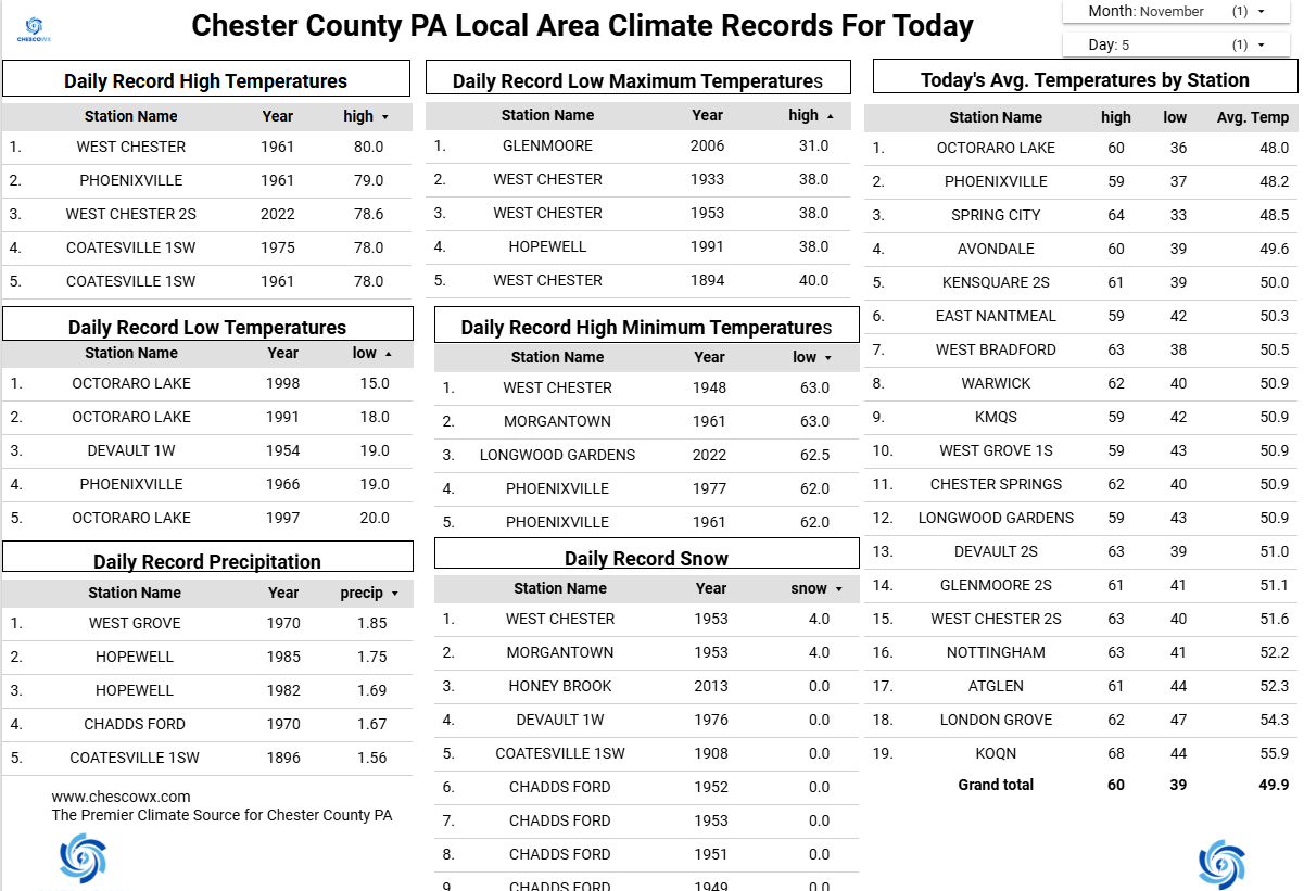
Warwick Township hit freezing for a low this morning for the 10th time this season while higher spots like East Nantmeal still have yet to experience either a frost or freeze. That streak has a chance to end by Friday morning for many of the higher spots across the area and if not certainly by early next week with our coldest air so far this season. Winds will slowly increase today first out of the southwest ahead of the cold front and then out of the northwest and increasing with gusts as high as 40 mph between 10pm and midnight. The NWS has issued a wind advisory from 7pm tonight till 7am tomorrow morning. Today’s highs today into the low to mid 60's but about 10 degrees cooler tomorrow. We warm up again for the weekend to temperatures a few degrees above normal before we fall well below normal to start the new work week. Our best rain chances look to be Friday night.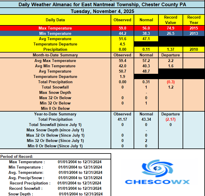

-
E PA/NJ/DE Autumn 2025 Obs/Discussion
ChescoWx replied to PhiEaglesfan712's topic in Philadelphia Region
Warwick Township hit freezing for a low this morning for the 10th time this season while higher spots like East Nantmeal still have yet to experience either a frost or freeze. That streak has a chance to end by Friday morning for many of the higher spots across the area and if not certainly by early next week with our coldest air so far this season. Winds will slowly increase today first out of the southwest ahead of the cold front and then out of the northwest and increasing with gusts as high as 40 mph between 10pm and midnight. The NWS has issued a wind advisory from 7pm tonight till 7am tomorrow morning. Today’s highs today into the low to mid 60's but about 10 degrees cooler tomorrow. We warm up again for the weekend to temperatures a few degrees above normal before we fall well below normal to start the new work week. Our best rain chances look to be Friday night.
-
Overnight Wednesday, November 5, 2025 Wind Event
WinterWolf replied to weatherwiz's topic in New England
Ya, but Tropical is when SNE will get the goods(if it’s legit tropical). It’s just that that doesn’t happen very often at all. -

2025-2026 ENSO
40/70 Benchmark replied to 40/70 Benchmark's topic in Weather Forecasting and Discussion
2000-2001 was great for the interior NE, but yea....nothing is absolute. -
2025-2026 ENSO
40/70 Benchmark replied to 40/70 Benchmark's topic in Weather Forecasting and Discussion
Enter Bluewave with the modled Pac jet being the storngest of the past several on the Euro seasonal "We'll have to see if the temp composites adjust to account for that as they have the last 7 years in this new, warmer climate". -

November 2025 general discussions and probable topic derailings ...
SJonesWX replied to Typhoon Tip's topic in New England
when does the warmup start? asking for a friend -
first call: BWI: 39.6" DCA: 27.8" IAD: 43.2" RIC: 15.9" ----- SBY: 17.1" a bunch of small to medium events with a big 8-16" that we've waited 10 years for
-
Lock it in!