All Activity
- Past hour
-

November 2025 general discussions and probable topic derailings ...
weatherwiz replied to Typhoon Tip's topic in New England
I hope we get smoked for the first half of winter and then warm up in March. I've been thinking about this lately. As much as I hate the cold, its tolerable in December, January, and February but by the time March rolls around...I'm done, fed up, ready for warmth. Hoping for about 20-25" in December and January, then 30-40" in February, then off to the 70's in March. -

2025-2026 ENSO
donsutherland1 replied to 40/70 Benchmark's topic in Weather Forecasting and Discussion
I see your point. The argument for RONI is that the overall warming of the Pacific is not temporary or cyclical. The use of traditional ENSO metrics i.e., R3.4 anomaly, ONI, etc., has beenb contaminated by the overall warming of the Pacific. In their present form, El Niño events are amplified while La Niña ones are shown as weaker. As the warming continues, La Niña events could even be obscured. Winter 2024-2025 is one such case. It showed up as neutral-cold on ONI, but was a La Niña case according to RONI. Some useful literature on the use of a relative index: https://iopscience.iop.org/article/10.1088/1748-9326/abe9ed https://journals.ametsoc.org/view/journals/clim/37/4/JCLI-D-23-0406.1.xml Australia's Bureau of Meteorology (BOM) has already made the switch to RONI. Here's a table from the article concerning the BOM's shift: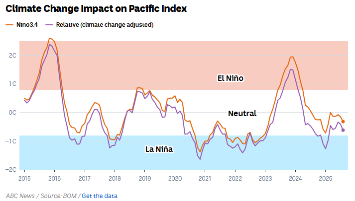
-
Yuck. I hope it’s warm from now until mid-December. Winter can start after that.
-

2025-2026 ENSO
40/70 Benchmark replied to 40/70 Benchmark's topic in Weather Forecasting and Discussion
It should. The conjecture about locking through January is silly. -
It does seem like this event is increasingly projected to pretty quickly rebound by mid month Dec. We'll see if the MJO has anything up its sleeve regarding a 2000 situation
-

November 2025 general discussions and probable topic derailings ...
Ginx snewx replied to Typhoon Tip's topic in New England
Sweet as Jeff said this is how you run a November -
 Exchanging emails with Harv….
 -
im calling for 80-100 inches of digital snow this season
-

2025-2026 ENSO
so_whats_happening replied to 40/70 Benchmark's topic in Weather Forecasting and Discussion
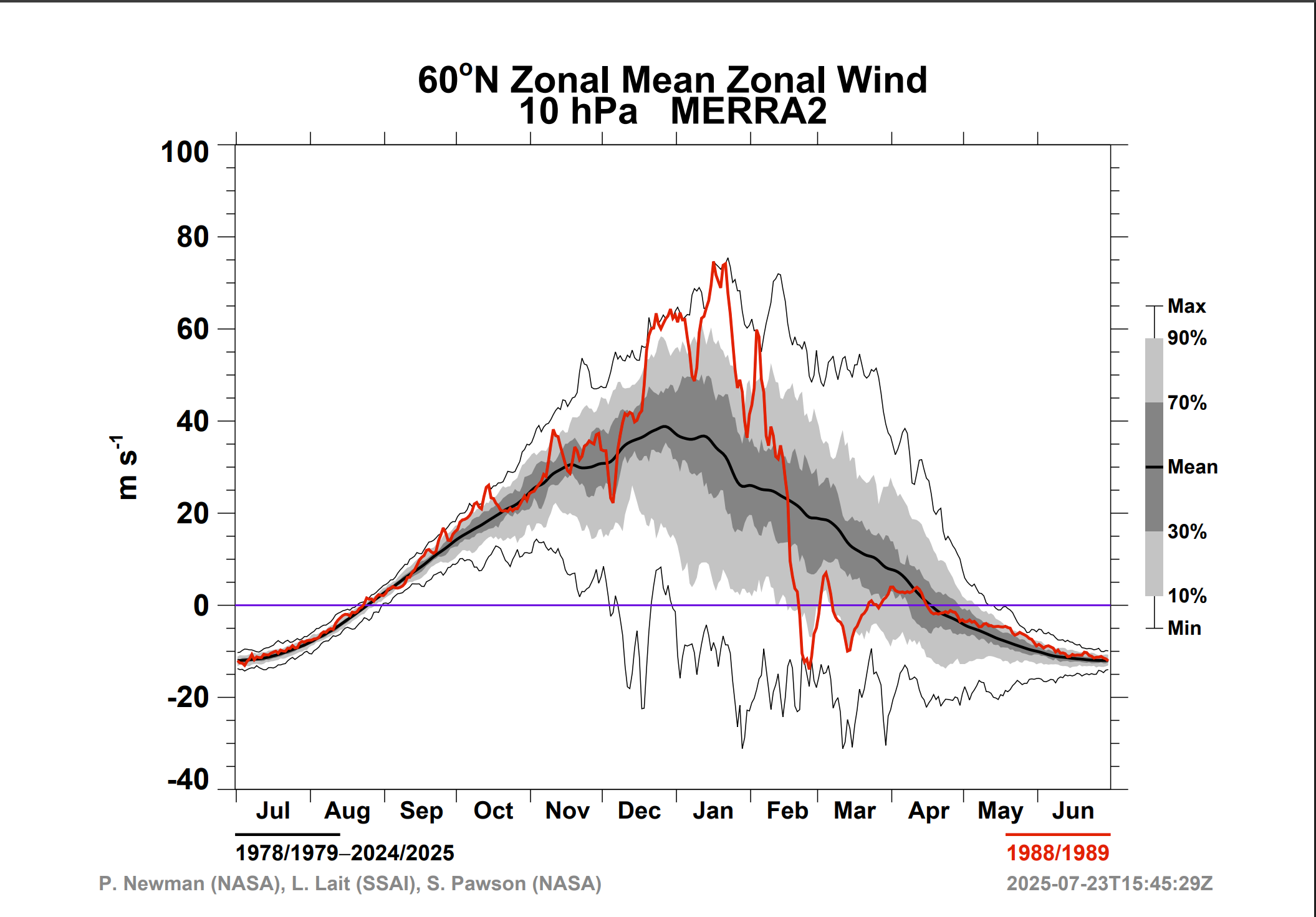
This might help you out https://acd-ext.gsfc.nasa.gov/Data_services/met/ann_data.html
-
Winter 2025-2026 Thoughts
donsutherland1 replied to donsutherland1's topic in Weather Forecasting and Discussion
It could. That's the wild card so to speak. 2017-18 is in the analog mix. It saw 7.7" snow in December and 40.9" overall. 2016-17 had 3.2" in December and 30.2" overall. -
Don't count your chickens before they hatch - hard to believe there won't be a significant storm in the next 2 weeks with the next cold fronts and much colder air on the way..........
-

Central PA Fall Discussions and Obs
Itstrainingtime replied to ChescoWx's topic in Upstate New York/Pennsylvania
Part of my job in regards to corrective actions is having 1X1 meetings with employees who violate what's essentially our code of conduct. It amazes (okay, saddens) me how many people in society today have lost the ability to treat others well. It isn't hard. If you don't have something nice to say, shut your mouth and walk the other way. I think the ability to hide behind a keyboard has emboldened people to say things they would have never said face to face prior to the internet/cell phone use. -
Well the low-frequency background state shows low heights in the east during the time period where MJO is most likely not projecting so the pattern is likely to stay generally seasonal. I wouldn't expect a massive warmup or anything but more of a moderation

-

November 2025 general discussions and probable topic derailings ...
Typhoon Tip replied to Typhoon Tip's topic in New England
yeah I added a couple examples of in-betweeners. Feb 2002 10" in 3.5 hours along the Pike E of ORH and throughout Boston proper, from a flat vort max rippling through. It was so flat that there was but a west wind while it was happening. Forced NWS to go from a partly sunny with flurries forecast to a Winter Storm warning cut-in now-cast adjustment in a scrambling media effort. That's definitively showing that timing crucial variables can generate fun stuff and not be well modeled. Then there was Dec 23 1997 ...one of my favorites. It's close to my heart because I was interning with Harvey Leonard that semester, and I remember telling him the day before that I was suspicious about the setup. The ( then ) ETA FOUS grid, ( a dead art form) had a vertical profile over Logan something like +2|+1|-3 ... which corresponds to 34.5 F at 980 mb, 33 F at 900 mb, at 27 at 800. The VV column was like +22 ... whaa Uh, that's a pig ton of implied upward motion. Underneath which it was dropping over a half inch of QPF. All rain didn't add up in my mind. Should have no problem having fall rates of snow over come that gossamer lower warmth. Yet, NWS was forecasting cold rain inside of 128, with 1-3" of wet glop in the Worcester Hills. At a larger synopsis, there was a small but important +PP sitting over N Maine while this event was approaching in the guidance - this was showing up as damming in the surface pressure contours. I told him more snow. So Acton Ma, and I awoke around 7:30 or 8 am to slate gray blue tinted light and flurries at 19 F... umm. What happened was it remained like James Webb Telescope clear until about 5:15. Then, just before dawn, the cirrostratus leaf edge abruptly advanced over and cold capped. 800 mb ( mind you ) was already less than 0C - there was no way to switch the column. I set my coffee, most down curious what the radar must be showing, but just then my primitive Captain Kirk flip phone captured my attention, "You have 14 new messages". It was this guy I knew that worked at Aldin Electronics( long defunct ) - he was in the EPERB department, which was a weather monitoring tech for marine. First and foremost, he and I were in a dead heat for weather dweebiest contest and the mother fucker beat me to it. At his urgency I opened the radar and it was 60 dbz returns over an area twice the size of fuckum Rhode Island over eastern CT up to the Pike. That globular region was surrounded by 30 to 50s. Yellows and fiery oranges you'd see in plains super cells. The deep green leading edge was just then arriving overhead. "OH shit!" I leaped to my feet and rush to the window; the flurries abruptly had indeed become steady snow. Tiny little uniform aggregates reducing the visibility abruptly. "That's isn't just bright banding or sleet. Oh my god" An hour later, visibility was 0 not 1000 feet where ASOS might only say so. It was 0 Could not see the tree in the front yard. So okay ...maybe visibility was technically 20 feet. I saw 7" fall in a single hour in that as the thunderstorm colored rad blog moved over head. And snow texture never deviated. The temperature never wen above 27. 16.5" most of which fell in 4 hours. Straight down. No wind. So dense that there was no sound except the gritty crumbling of tiny aggregates shattering down your shoulders, in 0 visibility. I'd never seen anything like that. It was unique. I've seen 0 or close to 0 visibility on several occasions. Wind was usually a part of those. This had nothing but a single expression: choke snow fall rates. -
Hopefully get into some clearing here and sunshine
-
2025-2026 ENSO
so_whats_happening replied to 40/70 Benchmark's topic in Weather Forecasting and Discussion
Oh man I feel like we go through this every winter. Warmings occur all the time this is not a new occurrence by any means. I do like to see there is some connection through the layers to show maybe some extended connection as we go through time but anything past 240hr is typically a crapshoot call even with something like the stratosphere which doesn't tend to have too much change. My biggest issue with the use of RONI being implemented what if for some reason this process does actually switch up and ONI does become more representative than RONI are we going to switch back to using ONI data as reliable indication of Nina/Nino severity? To me RONI is like the equivalency of saying well if we take out the warming of the last 50-100 years in something like air temperature (just an example) to show that in fact temps would have been cooler during this time period to me means nothing. Ok we have deduced that it is warmer now than in the past. The processes that are involved with ENSO/ IOD/ PDO/ AMO have not seemingly changed, they all still evolve in the same manner. Are we trying to say that RONI is showing enhancement of La Ninas specifically? Are you and bluewave stating that because RONI showed -1.12 last winter for DJF that the winter acted like a moderate La Nina versus cold neutral? I mean just taking a quick glance at years of similar ONI where we never officially hit Nina status by measurements (some awfully close like last year). I did not match scales so forgive me on that. Only difference I see is a slightly more poleward low position in the pacific. I feel this is more of a PDO situation.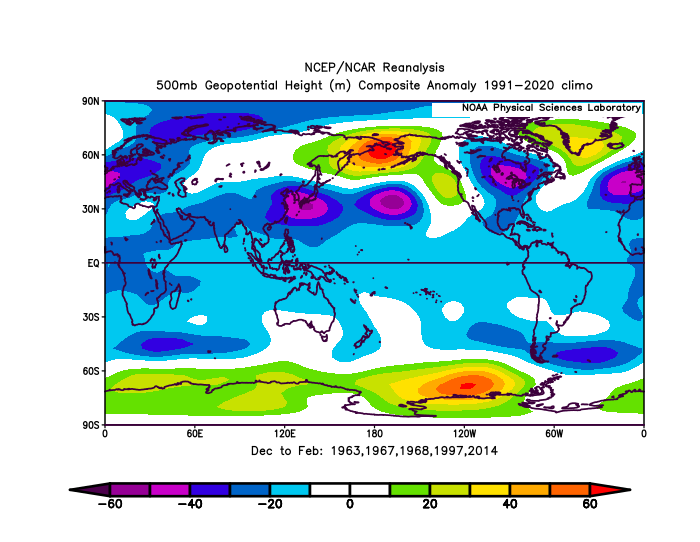
-
Central PA Fall Discussions and Obs
Itstrainingtime replied to ChescoWx's topic in Upstate New York/Pennsylvania
I was wondering where you were. I haven't seen anything from you in a while. -
Central PA Fall Discussions and Obs
Itstrainingtime replied to ChescoWx's topic in Upstate New York/Pennsylvania
Keep an eye on the winds this afternoon - CTP has gusts close to 30, MU says winds are going to reach 40 at times. Something to watch during a quiet weather period. -
good for folks who are traveling for the holiday and long weekend
-

Central PA Fall Discussions and Obs
canderson replied to ChescoWx's topic in Upstate New York/Pennsylvania
There is absolutely no reason to be an ass. -

2025-2026 ENSO
PhiEaglesfan712 replied to 40/70 Benchmark's topic in Weather Forecasting and Discussion
1949-51 la nina -> 1951-52 moderate el nino (yes, also continued in 1952-54) 1954-57 la nina -> 1957-58 strong el nino (yes, also continued in 1958-59) 1970-72 la nina -> 1972-73 super el nino (yes) 1974-76 la nina -> 1976-77 & 1977-78 moderate el nino (yes) 1983-85 la nina -> 1986-88 strong el nino (yes) 1988-90 la nina -> 1991-92 strong el nino (yes) 1998-2001 la nina -> 2002-03 moderate el nino (yes) 2007-09 la nina -> 2009-10 strong el nino (yes) 2010-12 la nina - no el nino in 2012-13 or 2013-14 (though we did get a super el nino in 2015-16) 2016-18 la nina -> 2018-19 weak el nino (no) 2020-23 la nina -> 2023-24 strong el nino (yes) So, within 2 years of a multi-year cold ENSO (at least one year la nina), we have: 1 no el nino (and this one eventually produced a strong el nino) 1 weak el nino 3 moderate el nino 5 strong el nino 1 super el nino Plus, 4 of these events were multi-year el ninos (1951-54, 1957-59, 1976-78, and 1986-88). -
Probably for some of the same reasons other multi- year snow droughts have occurred in NYC - shouldn't be surprised... monthlyseasonalsnowfall.pdf
-
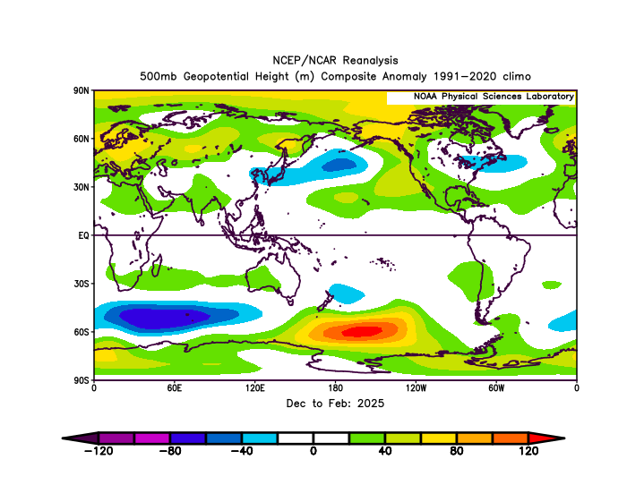
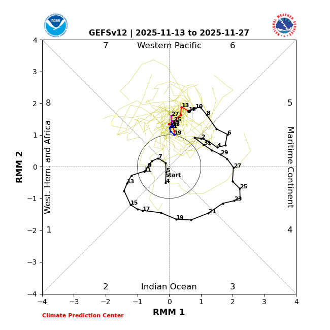
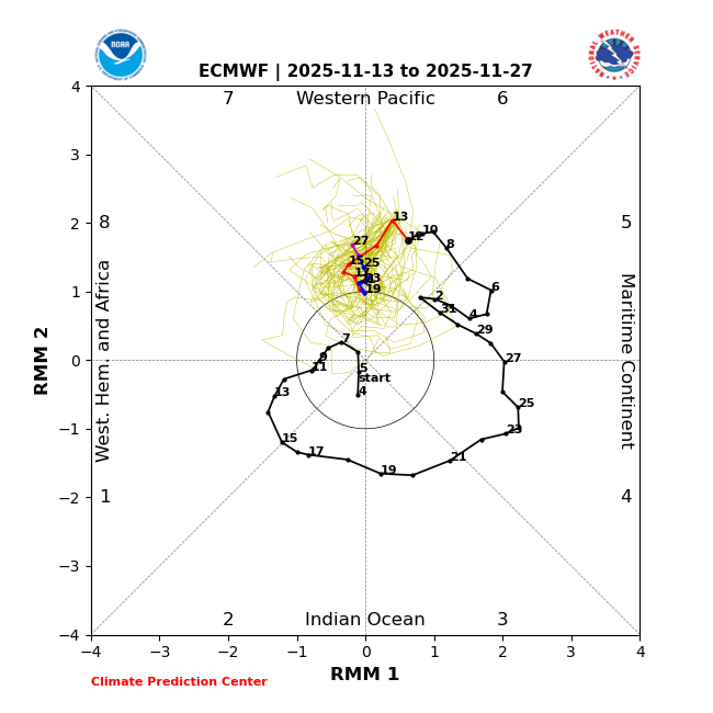
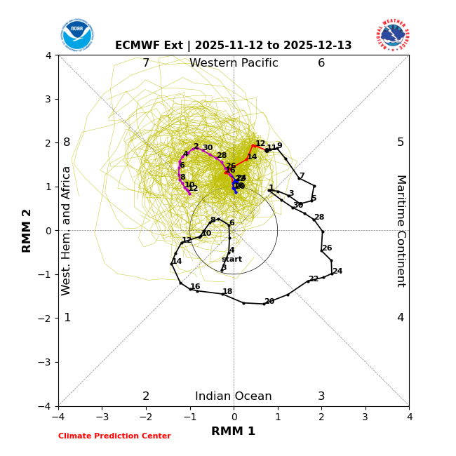
Today’s 2 week GEFS and EPS MJO progs are in very good agreement on the MJO being hung up near the 6/7 border with moderate intensity: GEFS: EPS: Here’s yesterday’s (11/12/25) extended EPS (these always come out at this site a day later): after the near 2 week long stall near the 6/7 border, it crawls through 7 and then barely into 8 with a trajectory that suggests it might collapse into within the circle/weak amplitude soon afterward. But keep in mind that should it actually occur, a weak amplitude doesn’t at all necessarily mean mild in the E US as weaker MJO on the left side is often associated with cold based on analyses I’ve done and posted here plus charts I’ve seen from others: just outside the circle phase 8 in Dec like this shows has sometimes been associated with quite cold in the E US:
-

November 2025 general discussions and probable topic derailings ...
dryslot replied to Typhoon Tip's topic in New England
Love this, What a great winter scene, Off to a good start this year where it suppose to be at this time. -

November 2025 general discussions and probable topic derailings ...
powderfreak replied to Typhoon Tip's topic in New England
6” of heavy pasty snow at the office. 9” at the upper plot.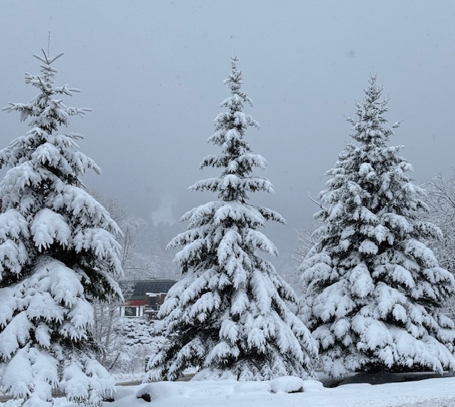

.thumb.jpeg.406ecda2eec9e267302c22b9f128fe3c.jpeg)