All Activity
- Past hour
-

2025-2026 ENSO
donsutherland1 replied to 40/70 Benchmark's topic in Weather Forecasting and Discussion
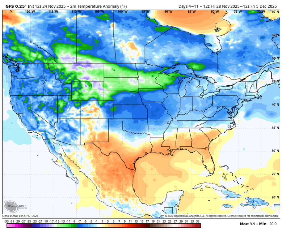
The growing concern isn't December 1-10. That still seems on track. The issue concerns what happens afterward e.g., should the GEFS's AO+ scenario develop. The GEFS compounds the issue with the development of an EPO+. The persistent PNA- remains in place. -
if I could react to my own posts, I would react with a weenie as well
-
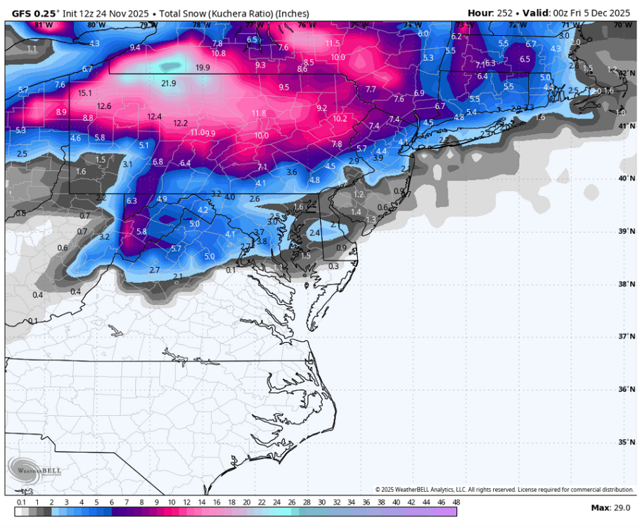
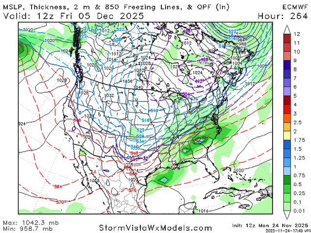
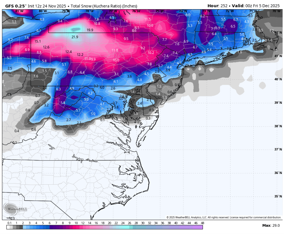
12z Euro has a Dec 5-6 coating
-
Euro

-

November 2025 general discussions and probable topic derailings ...
MJO812 replied to Typhoon Tip's topic in New England
Euro has also trended colder in the mid range
-
2025-2026 ENSO
donsutherland1 replied to 40/70 Benchmark's topic in Weather Forecasting and Discussion
That's why CPC using averages for the last 16 cycles on the CFS's maps. It's bad practice to treat the CFS as a deterministic operational model. That doesn't stop the vendors from providing such information to an often unaware audience (unaware of the tool's limitations). -
Euro has also trended colder
-
i fear i'm too young to get this reference... is that like today's weenies running custom wrf models off of the 300hour GFS initial conditions?
-

Fall 2025 Medium/Long Range Discussion
sbnwx85 replied to Chicago Storm's topic in Lakes/Ohio Valley
Euro pretty much the same as last night on snowfall. Maybe spreads the wealth a little more north. -
12Z Euro says hold on.
-

Fall 2025 Medium/Long Range Discussion
cyclone77 replied to Chicago Storm's topic in Lakes/Ohio Valley
I still have a windows 95 machine cranking out NGM runs. -
i hear the korean is the one to ride this winter....
-

Mid to long range discussion- 2025
WinstonSalemArlington replied to wncsnow's topic in Southeastern States
Spot the MegaCAD (December 3) -
You must be new
-
2025-2026 ENSO
donsutherland1 replied to 40/70 Benchmark's topic in Weather Forecasting and Discussion
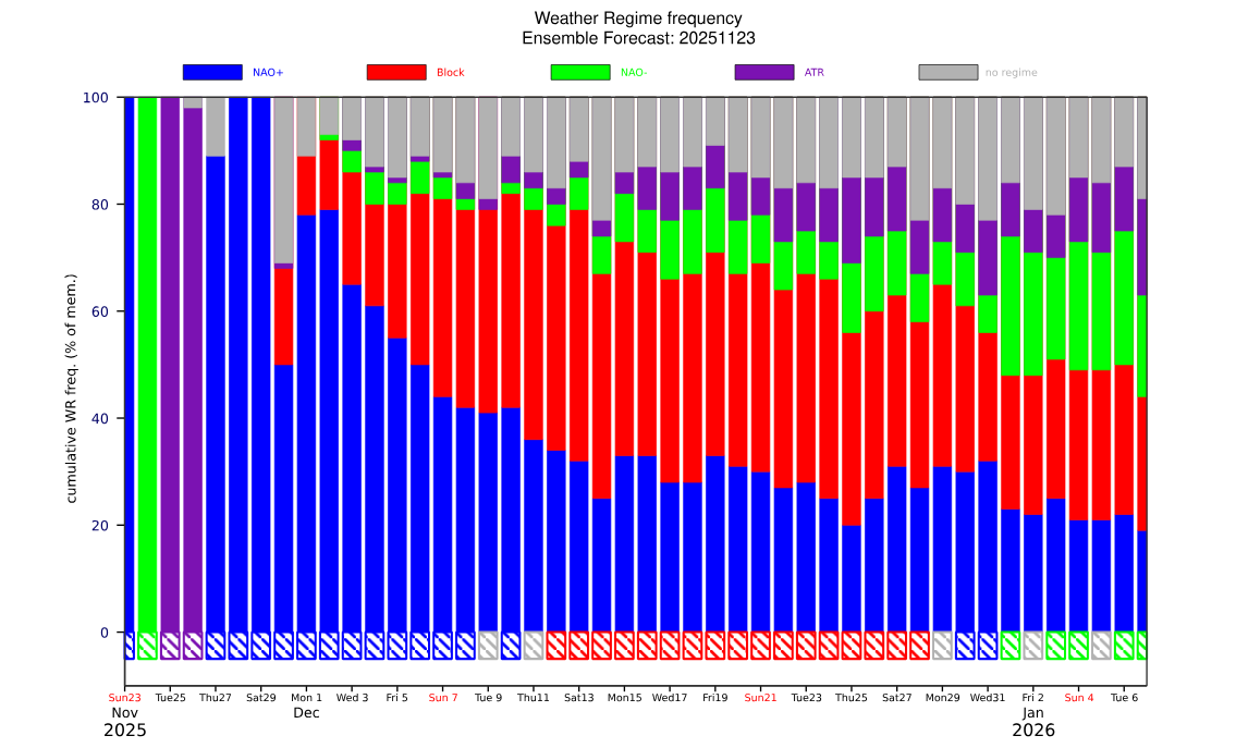
Right now, the long-range European guidance is suggesting the development of a Scandinavian Block near mid-December onward. That's not an AO-. Your location should be ok. Things should also be ok for cities such as Chicago, Detroit, Toronto, Ottawa, Montreal, etc. If the AO is more positive, areas south of New England would typically see a warmer outcome with reduced snowfall prospects. The SE U.S. looks warm, overall, for December, as the predominant regime through most of December is forecast to be NAO+ yielding to a Scandinavian Block.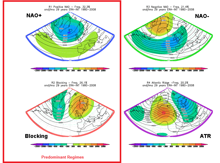

-

Fall 2025 Medium/Long Range Discussion
Chicago Storm replied to Chicago Storm's topic in Lakes/Ohio Valley
stop looking at the op gfs. -

December 2025 Short/Medium Range Forecast Thread
Carvers Gap replied to John1122's topic in Tennessee Valley
And the 12z CMC has similar look to both the AIFS and GFS. EPO anyone? -

November 2025 general discussions and probable topic derailings ...
ORH_wxman replied to Typhoon Tip's topic in New England
12z GFS def had several chances in the long range. That period after about 12/2 gets pretty interesting. There’s still risk that we end up on the warm side but I like seeing a lot of reinforcing PV shots into SE Canada…that’s ultimately what will give us the confluence and antecedent airmass we need. So the more reinforcing shots that we see on guidance, the better our chances. -
December 2025 Short/Medium Range Forecast Thread
Carvers Gap replied to John1122's topic in Tennessee Valley
The 12z CMC has a below zero air mass sitting in the Plains and Ohio River Valley as a couple of impulses originate in the Gulf and head northeastward. -

2025-2026 ENSO
TheClimateChanger replied to 40/70 Benchmark's topic in Weather Forecasting and Discussion
-
December 2025 Short/Medium Range Forecast Thread
Carvers Gap replied to John1122's topic in Tennessee Valley
The 12z CMC almost has a winter storm by 198. Big changes on the deterministic models at 12z today - noted that the Euro has yet to run. The Euro AIFS, GFS, and CMC are showing a cold shot around d10-12 which wasn't there on yesterday's runs. It is a bruiser. I doubt the ensembles will switch that quickly, but it is a trend worth watching. This cold front had been on LR ext modeling for weeks, and then disappeared. edit...the CMC is actually close to something good 3x. -
Yeah we just have a crusty couple inches in the yard and the fields are melted out. Highly elevation dependent start to winter. Only saw 3” total 24 hrs at all plots at Mansfield, like you said.
-
Yeah I mean it’s early. It’s hitting like late January pessimism. Canadian further south [emoji2957].
-
Upslope was a dud..probably about 3” total..big difference from valleys near jay like Montgomery and Stowe village at 750’ in snow cover. Mansfield is in good shape tho, but can’t see shit at the top. .
-
2025-2026 ENSO
TheClimateChanger replied to 40/70 Benchmark's topic in Weather Forecasting and Discussion
Incredible stuff, with NHEM anomalies pushing up towards 2C above the 1981-2010 mean as we head towards the end of the month. This has been one heck of a hemispheric heat wave over the last month or so.


.thumb.jpg.ad3a2e31d30aff035044689b311a0540.jpg)