All Activity
- Past hour
-
You can tell how fake the cold is, when someone sneezes the temperature jumps up several degrees. I was in the upper 40s but a 4 mph wind was recorded and it resulted in temps jumping into the lower 50s.
-
931.7 extrap
-
Latest recon pass found 128 kts flight level in the right quad, so that has been pretty steady.
-

Spooky Season (October Disco Thread)
ineedsnow replied to Prismshine Productions's topic in New England
second pass 931.7 -
Also the various cruise ports, which Jamaica relies a ton on for tourism.
-
You might want to sit this one out. I by no means support any type of homophobic behavior but this is an absolutely disgusting post. This is an extremely dangerous storm and there is a good chance people will die. .
-
Are they finding any higher winds along with these big pressure drops?
-
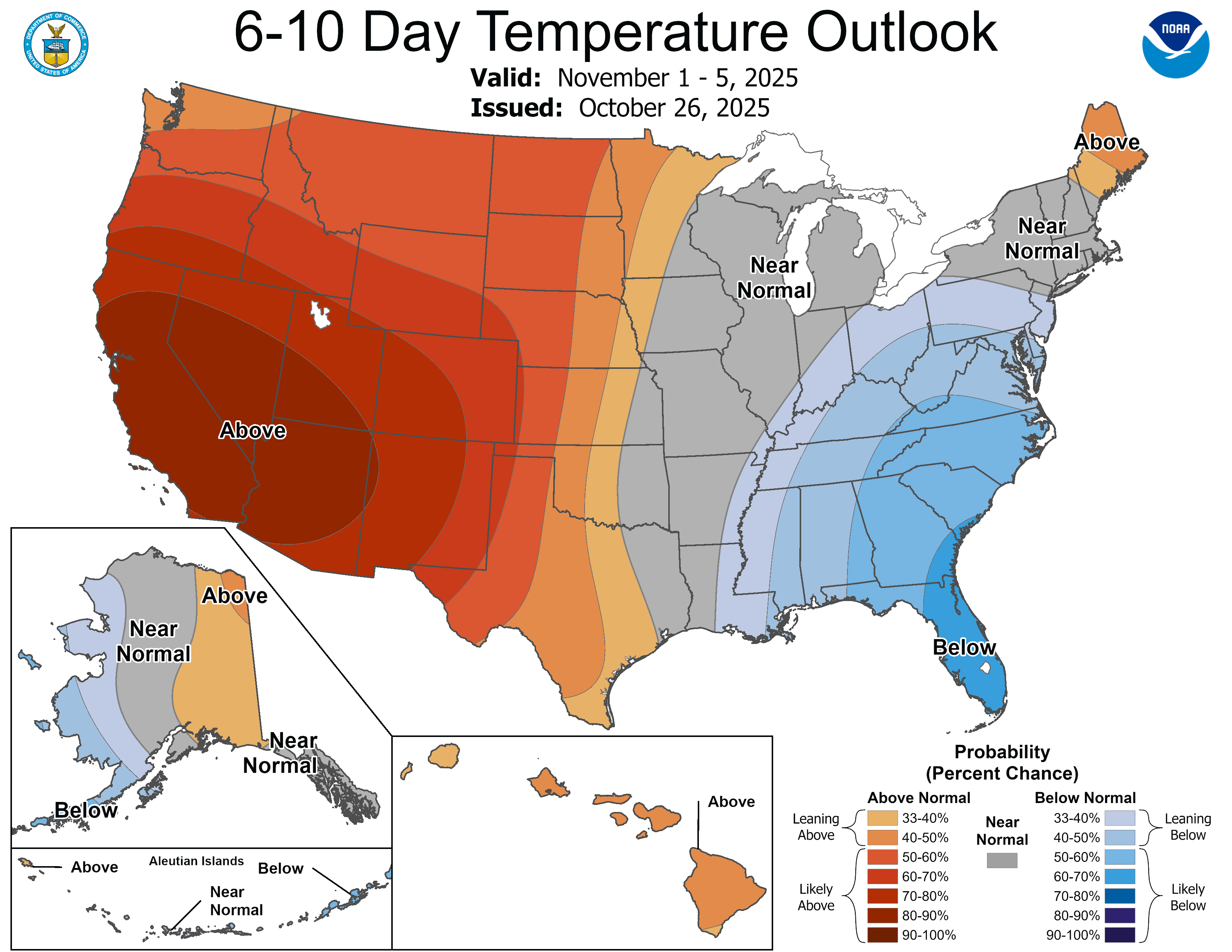
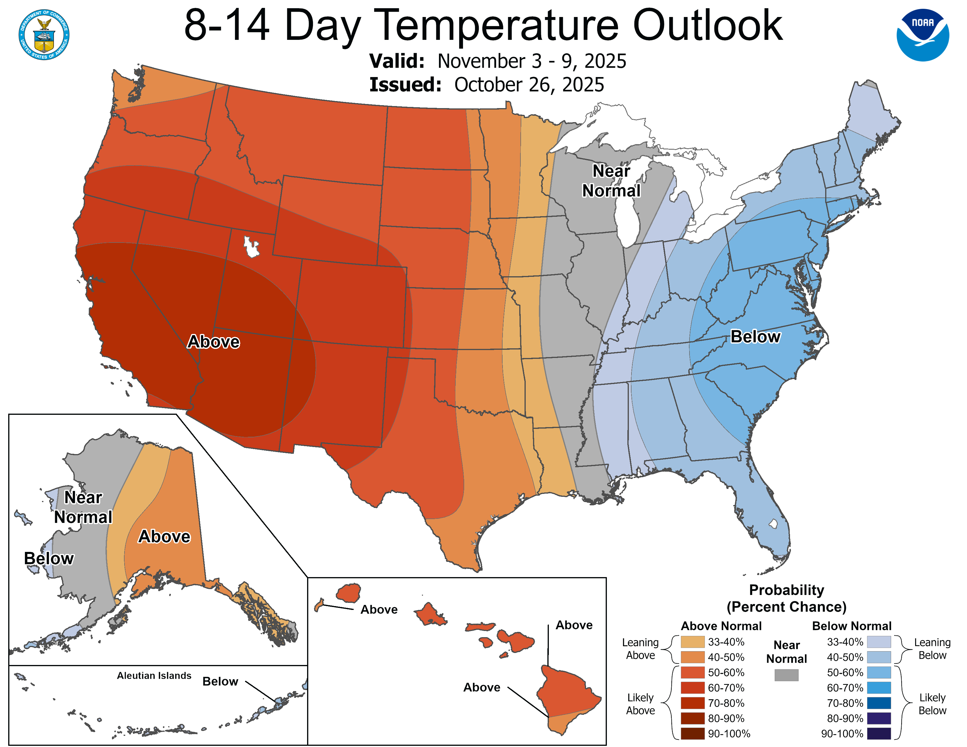
I really like the positioning of the west coast ridge and Alaskan trough as we head into November. That's a decent sign for winter.
-
The wind field seems to be expanding a bit per recon
-
That is true. As far as intensity and surge impacts but the more west it goes the more rural areas the core of hurricane will impact. However the surge and extreme rainfall impacts will still be impactful well east into more populated areas.
-
lol what are these Stiller uniforms?? lol sooooo bad
-

Spooky Season (October Disco Thread)
WxWatcher007 replied to Prismshine Productions's topic in New England
-
Your observation is probably(at least partly) because we have had quite a cool early Fall that has continued through October, instead of the usual second summer that can be warm right into mid October. Color definitely seems ahead of schedule here. Nearing peak. The upper Midwest has also been generally above normal, so without significant elevation differences it probably evens out. Just my take.
-

Spooky Season (October Disco Thread)
OrangeCTWX replied to Prismshine Productions's topic in New England
Jesus things aren’t looking too good for Jamaica. Its a compact hurricane but its going to be an absolute buzz saw in the areas that are exposed to the eyewall. -
I just realized that I joined AmericanWx on December 3rd, 2010 so on Dec 3rd I will have been in AmericanwWx for 15 years!! That's longer than both my marriages ! Lmaoo
-
Next 2 weeks definitely a cool down in the east..


-
A spectacular Fall day. A high of 54 and current temp of 44.
-
BULLETIN Hurricane Melissa Intermediate Advisory Number 22A NWS National Hurricane Center Miami FL AL132025 800 PM EDT Sun Oct 26 2025 ...LIFE-THREATENING AND CATASTROPHIC FLASH FLOODING AND LANDSLIDES EXPECTED IN PORTIONS OF JAMAICA AND SOUTHERN HISPANIOLA THROUGH MIDWEEK WITH HURRICANE FORCE WINDS LIKELY TO BEGIN TOMORROW... SUMMARY OF 800 PM EDT...0000 UTC...INFORMATION ---------------------------------------------- LOCATION...16.4N 77.3W ABOUT 115 MI...185 KM SSW OF KINGSTON JAMAICA ABOUT 295 MI...475 KM SSW OF GUANTANAMO CUBA MAXIMUM SUSTAINED WINDS...145 MPH...230 KM/H PRESENT MOVEMENT...W OR 270 DEGREES AT 5 MPH...7 KM/H MINIMUM CENTRAL PRESSURE...933 MB...27.55 INCHES
-
Spooky Season (October Disco Thread)
ineedsnow replied to Prismshine Productions's topic in New England
very cold cloud tops wrapping around the western eyewall now.. shes about to explode -
DP is 29/30 in Muttontown, should be around freezing tomorrow for the low.
-
I missed 2009 in college in VA Beach, but it was the first 12"+ snow in greater McDowell since Jan 96. It's been 7 years since our last 12" snow. 2022 was close but not quite.
-
There’s resorts on the west part of the island too. Might be worse vs where it’s currently forecasted to go.
-
Only positive is that Melissa might be far enough west to keep Kingston area out of the eyewall winds and the south coast of Jamaica isn't that surge prone. Biggest threat has been and continues to be the flooding as hazwoper just mentioned. Farther west track unfortunately subjects more of the island to very high rainfall totals and the NNE trajectory is unfortunately very favorable to squeezing out the moisture via orographic lifting.
- Yesterday
-

Spooky Season (October Disco Thread)
powderfreak replied to Prismshine Productions's topic in New England
Classic mild 50s to 19F blizzard in Denver. -
I don’t think you are truly grasping what 30” of rain in Kingston means. The entire island is in big trouble