All Activity
- Past hour
-
We spiked to 48.4 at 9:40 am and are down 2 degrees since. That's been happening a lot recently with the max before 10am. I have no explanation for why. I noticed the same on a couple of other local sensors.
-

White Christmas Miracle? December 23-24th
WxWatcher007 replied to Baroclinic Zone's topic in New England
If there is an IVT, coastal Maine might clean up. -

White Christmas Miracle? December 23-24th
WinterWolf replied to Baroclinic Zone's topic in New England
Nice. It’s the Icon, but it’s nice. -
Yeah I was surprised how warm it felt this morning, felt like Spring compared to the cold we've had recently. Webb seems to think we're in for a warm winter unless the pacific has a big shake up.
-
December 2025 regional war/obs/disco thread
WinterWolf replied to Torch Tiger's topic in New England
You sir, are a fraud. Let’s ask how NNE is doing so far this December? In case you don’t know, quite possibly the best and most snow on record for December, and we still have 10 days left. Mount Mansfield snow stake is/was at record levels. So as I said, you are a fraud. -

White Christmas Miracle? December 23-24th
Baroclinic Zone replied to Baroclinic Zone's topic in New England
-

Possible Light Snowfall (1" - 4") on Tuesday Dec 23
sussexcountyobs replied to Northof78's topic in New York City Metro
http://youtube.com/post/UgkxqJNruw0VV6CFUpiaAINruvu2TBBBpsrK?si=Uf-dMFelpUCGyPJG -
I'll double your exactly and agree! This may be a little off-topic, but what you allude to about modes of thinking is the reason I roll my eyes when I hear people say how 2015-16 was totally sucky and a torch except for the one big storm in January. Well...that's a rather large "exception" ("Other than that, Mrs. Lincoln, how did you like the play?")!! Not to mention, I believe that thinking is skewed by the ridiculous month-long torch in December, which averaged +8 to +10 for the month across the area. But take a look at January and February, at just DCA for example. We were 2-3 degrees colder than normal in January and about normal (very slightly below) in February. Yeah, the last week or so of that February got warm, but let's not pretend that the big January blizzard was the only chance we had and everything else was wall-to-wall torch. We did get a rather interesting event around Presidents' Day, ice/snow, that seems to slip under the radar in recalling that season. Did we have other chances in the 6 week period from early January to mid-late February? Maybe, I don't exactly recall...but I bet if we got just one more moderate advisory or warning-level event people wouldn't be saying it was a failure "except for one event". Heck, I still like the winter of 2006-07...after a warm December and first part of January, things flipped and we had an extremely cold February. Yeah, we missed out on big snow for that Valentine's Day (but 3" sleet and ice followed by very cold!), but we did have chances and I still like that season even though it was below normal in terms of actual snow. Or even 2014-15...sucky until Valentine's Day that year, and we had a concentrated 3-4 week period of intense winter! But people don't talk about how that winter was all crap "other than..."
-
Big guidance beat today with some spots sneaking in a 50° high so far. MacArthur/ISP PTSUNNY 50 21 32 W18G29
-
White Christmas Miracle? December 23-24th
Baroclinic Zone replied to Baroclinic Zone's topic in New England
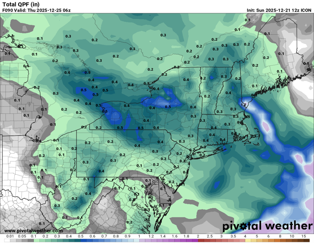
ICON on the juicier side of 12z guidance I agree with Wiz that there be decent fronto pushing through the area. -
The cruel irony about a -NAO with a raging Aleutian ridge is we’re going to be warm and wet. We’ll finally have a mechanism for digging and getting the moisture here.
-
White Christmas Miracle? December 23-24th
WinterWolf replied to Baroclinic Zone's topic in New England
Now see, that ain’t true at all. That’s where you are misled. If it sucks I have no issue saying so. But when things are trending or morphing(whatever word we want to use), we need to see things through until we get closer in, and see if we are indeed in the game, or not. And yes, the last 4 years especially, have been bad for us snow peeps…no argument there at all. But if I/we can pick up a couple inches on the 23rd…I’m pleased about that. And that’s not being positive all the time…that’s being level headed. -

White Christmas Miracle? December 23-24th
Snowcrazed71 replied to Baroclinic Zone's topic in New England
It's something. And maybe there'll be some left on the ground for Christmas Eve. It's better than having no chance. Either way, still looking forward to Christmas Eve and Christmas day. Leaving Christmas night for Canada so we should definitely have some good snow up there near Quebec City -
White Christmas Miracle? December 23-24th
WinterWolf replied to Baroclinic Zone's topic in New England
That’s not too shabby for CT…1-3” would be cool. Especially the timing of it being very close to Xmas. -

Possible Light Snowfall (1" - 4") on Tuesday Dec 23
Northof78 replied to Northof78's topic in New York City Metro
Nice trends over past day or so, of south/colder, TTN N looks good for 1-3" -
Now show the monthly temp departures in this region. Every time I think you’re going to add value to the forum you regress to bridge troll
-
What exactly Webb is seeing that screams to him "ugliest Jan/Feb he's seen in a long time" I'm not sure. He cites that there'll be strong +AO/+NAO tendencies but I doubt that'll be the case because I'm not sure how that domination throughout the whole winter would happen. Maybe there are a few +NAO periods but otherwise I wouldn't put much stock in what he says. There's a decent -EPO signal trying to develop for mid-January and the overall pacific looks to become better then as well
-
-
December 2025 regional war/obs/disco thread
WxWatcher007 replied to Torch Tiger's topic in New England
Yeah, it’s not a lock we keep surface cold into SNE. The warm push is trying and the low on the GFS is substantially stronger at 12z. We can’t discount that even if I lean euro at the moment. I don’t really care what the second tier models do but the ICON and Canadian were colder (Icon shows rain but the temperature profile suggests icing down into at least part of SNE). -
Plenty of time to trend that press stronger to get more posters in the game for a front ender at least. This isn’t cutting to the lakes. 6z euro shows how to get it done
-

White Christmas Miracle? December 23-24th
weatherwiz replied to Baroclinic Zone's topic in New England
There should be some decent frontogenesis that crosses the region. Still have a quite a bit to iron out with the details but there should be a sizable swath of 1-3 inches. Def some concerns with boundary layer temps in some spots, but that won't be much of a concern if we get a decent precip. shield and a far enough south track. -
Who cares about rain and 40s? This is the day after Christmas, looks fun!
-

December 2025 regional war/obs/disco thread
TauntonBlizzard2013 replied to Torch Tiger's topic in New England
Warmer than 6z. Keeps only far northern areas frozen -

2025-2026 ENSO
donsutherland1 replied to 40/70 Benchmark's topic in Weather Forecasting and Discussion
Webb describes a plausible scenario. It's not the only possibility, despite his skill and expertise. Prior to about 1980, December PNA- cases (-0.500 or below average) were typically followed by January PNA- cases. Since 1980, most cases have seen the PNA flip in January. The difference in PNA persistence could reflect the changes that have taken place due to Arctic amplification rather than statistical factors e.g., sample size. With Arctic sea ice extent continuing to set new daily record lows, the risk of a fairly abrupt change can't be ruled out. That there has been a strong clustering of December-January cases prior to and after 1980 (Dec PNA-/Jan PNA- prior to 1980 and Dec PNA-/Jan PNA+ since 1980) suggests that more than random variability is involved. That does not guarantee a flip to positive for January, but model skill at such a timeframe is essentially non-existent. Yes, both the EPS and GEFS paint a picture of a perpetual PNA-. But that's current modeling. The long-range isn't cast in stone, at least as far as January is concerned. Assuming a canonical La Niña winter, I think things are tilted toward a warm February, especially in the East. -
Exactly. All too often there are 2 modes of thinking here... wall to wall good or door to door turd lol. Through history the vast majority of our winters fall in between. A general mix of good periods and blind shitting. Simply guessing an in between winter is the highest odds and the most common outcome. This winter sure feels like an in-betweener to me