All Activity
- Past hour
-

2026-2027 Super El Nino
GaWx replied to Stormchaserchuck1's topic in Weather Forecasting and Discussion
I strongly disagree. 1951-80 has not been relevant base climo for anomalies for a very long time. Normals are supposed to reflect the most up to date available climo. We’re obviously in a notably warmer climate than that of 1951-80. That earlier colder climate is no longer relevant for determining normals. -
 over the counter sildenafil: Viagra generic over the counter - Viagra tablet online
 -
.thumb.png.3513c28619bf91f0fa8e4004956c33df.png)
2026-2027 Super El Nino
annunciated replied to Stormchaserchuck1's topic in Weather Forecasting and Discussion
Looks to me we will have another WWB in a week or so. The ECMWF suite, AIFS especially, has been pretty consistent on this signal for a few days now. -
Lawd it’s muggy out today. I can see light at the end of the summer tunnel though. The ‘ber months aren’t far away.
-

2026-2027 Super El Nino
bluewave replied to Stormchaserchuck1's topic in Weather Forecasting and Discussion
I am not sure there is need strong disagreement between us since the climate period keeps updating every 10 years. So each super El Niño at the time was based on the most recent prior 30 year period ending at the start of each new decade. I just checked the 30 year climatology from 1941-1970 in NYC and it didn’t change during 1961-1990 for the winters. Ultimately, it’s the rankings based on the entire climatology period which are the closest to reality. They probably should just have left the departures fixed at 1951-1980 which was our last stable temperature period before the warming accelerated. But since model forecasts use departures based on 1991-2020 this decade, we use them. I include rankings as often as possible since updating every 10 years in a rapidly warming climate masks the increase by normalizing the new much higher temperatures. So an average temperature month during the 2020s would have been would have been a warm month based on older more fixed climatology. -

Augdewst 2026: Summer's Last Stand
H2Otown_WX replied to Prismshine Productions's topic in New England
@RUNNAWAYICEBERG and I understand we are only to jackpot in rain events. During winter the jack will miss us in every conceivable direction. -
Augdewst 2026: Summer's Last Stand
H2Otown_WX replied to Prismshine Productions's topic in New England
Meh, that's a lot of money to sit on your ass and not issue watches -

Augdewst 2026: Summer's Last Stand
Snowedin replied to Prismshine Productions's topic in New England
Let’s keep the love train going right through Torchvember and Dewcember. Those white claws and natty lites ain’t gonna sip themselves! -
I think you are correct on that. This is nothing like the past two summers here. I am happy for this nice steady rain coming in as we put down lawn patch yesterday in hopes that this rain would pan out.
-
(002).thumb.png.6e3d9d46bca5fe41aab7a74871dd8af8.png)
Central PA Summer 2026 Discussion/Obs Thread
ChescoWx replied to Voyager's topic in Upstate New York/Pennsylvania
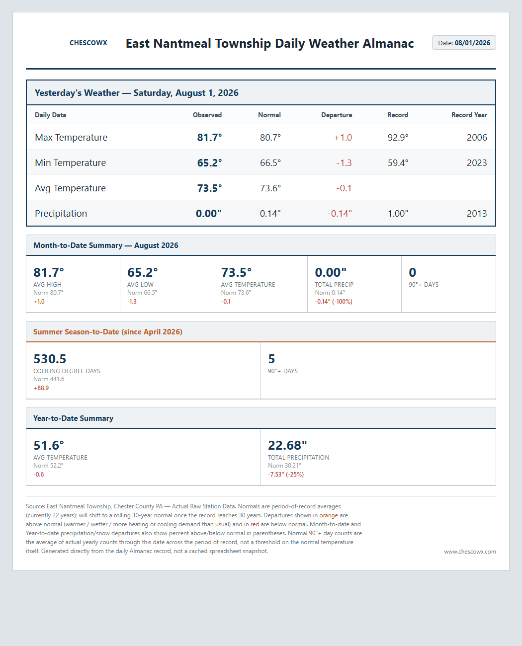
A pretty unsettled weather week on the way with shower chances increasing later today and becoming likely tonight into tomorrow. No washouts except for most likely tomorrow. Tuesday and Thursday look to be the relatively driest days before rain chances increase again to close out the work week. Temperatures this week are close to normal for the start of August.
-
E PA/NJ/DE Summer 2026 Obs/Discussion
ChescoWx replied to PhiEaglesfan712's topic in Philadelphia Region
A pretty unsettled weather week on the way with shower chances increasing later today and becoming likely tonight into tomorrow. No washouts except for most likely tomorrow. Tuesday and Thursday look to be the relatively driest days before rain chances increase again to close out the work week. Temperatures this week are close to normal for the start of August.
-
annunciated changed their profile photo
-
2026-2027 Super El Nino
GaWx replied to Stormchaserchuck1's topic in Weather Forecasting and Discussion
I fully realize that the 30 year climo period available during 1997-8, just like at the time for any winter, always has to end prior to that winter for obvious reasons. There’s no choice. But once one gets further into the future, a more appropriate 30 year period to use as a basis for the analysis of anomalies for any winter is imho the 30 years most centered on that winter. Otherwise, in a warming climate using a 30 year period that’s prior to that winter is always going to bias that winter to look warmer than it really was vs the best centered 30 year climo. So, I strongly disagree with you on this and I’ll leave it at that. I don’t expect for you to agree with my thinking here. That’s fine as there’s nothing wrong with that. These are solid debates, which I enjoy, rather than them being arguments/throwing cheap shots. -
Would be surprised if Mt holly doesnt issue flood watches at least for nw nj. They can't handle more than a couple inches
-
Yes sir!
-
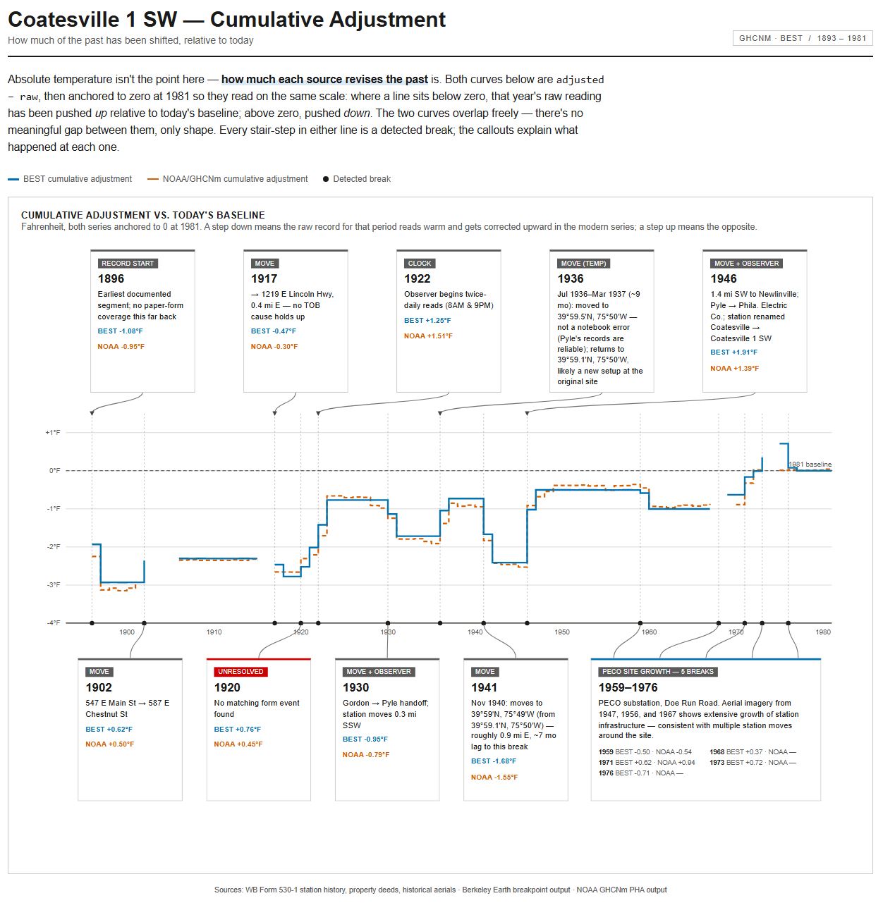
 Hi All, occasional lurker and Chester County resident here. I have done a deep dive on Coatesville 1 SW's history, working through the 530-1, the monthly paper records and property deeds for observers Gordon, Pyle and PECO. I then compared the record of station changes with the breakpoints identified by NOAA/NCEI and Berkeley Earth Surface Temperature (BEST). Claude helped with the graphic. There is remarkable agreement between the history of changes at 1 SW and the breakpoints detected. edit: The HOMR record for this station, (presumably pulled from the 1956 530-1 (itself likely pulled from the B44s)) is flawed.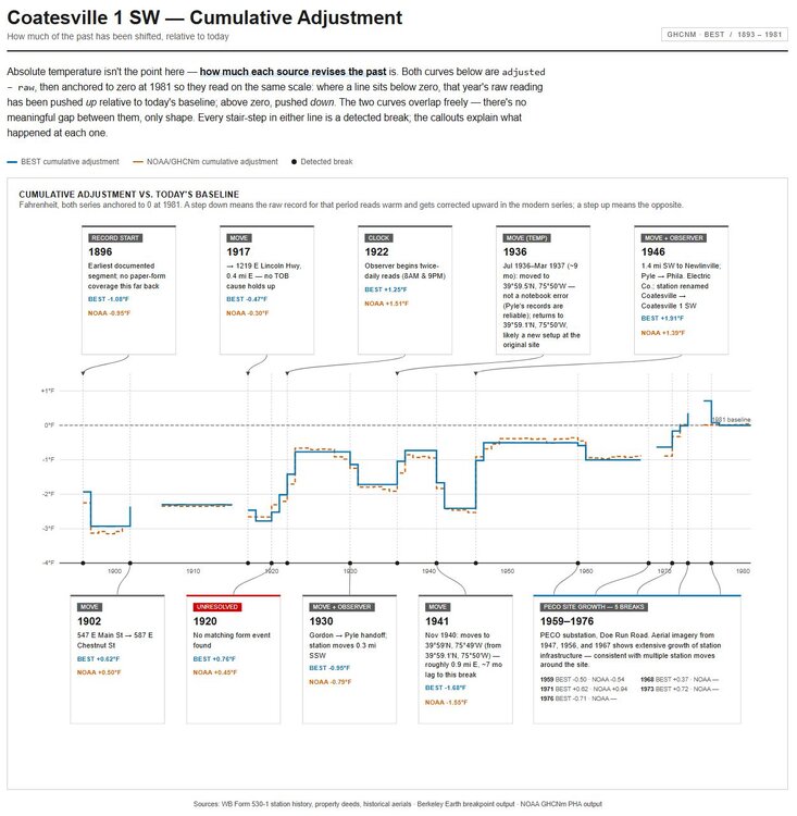
-
Yeah it just trained over them all night. Drought is on life support now for most areas
-
If the tropics showed any sign of life I'd be concerned about something sneaking into the southwest Atlantic and having a blocked escape route but tropics look to remain quiet for the next 7-10 days. Depending on how far west the ridge can flex this pattern could be one that produces above normal precipitation. Keep the weak trof axis along the Appalachians or over the Ohio Valley and the ridge off shore and a deep southerly flow could aid heavy rainfall, depending on synoptic setup.
-

Augdewst 2026: Summer's Last Stand
weatherwiz replied to Prismshine Productions's topic in New England
I'm shocked there aren't flash flood watches out or flood watches. I bet tonight into tomorrow evening has more reports of flooding than the past few setups combined. -
2026-2027 Super El Nino
bluewave replied to Stormchaserchuck1's topic in Weather Forecasting and Discussion
The climatology period for the 1997-1998 super El Nino was 1961-1990. They don’t have 1941-1970 climatology maps on that site for 1972-1973. There also isn’t an 1951-1980 option for 1982-1983. So I used the closest time period that they offered at the site. -
cheapest viagra [url=https://medmennews.xyz/#]Med Men News[/url] generic sildenafil
-
Yes. Probably @high risk can update us on that timeline but I thought it was like the end of August at one point?
- Today
-
Gross day out at DCL. Misty rain and a cloud forest up at 3k ft. At least it's cool. Packing up to head back to Calvert, sounds like it's more gross down there.
-
2026-2027 Super El Nino
GaWx replied to Stormchaserchuck1's topic in Weather Forecasting and Discussion
I assume you’re referring to the NE US. Regarding the US as a whole, nothing is even close to a certainty, especially this far out. Even the NE is far from certain though cold there is admittedly quite unlikely. And the SE actually had a downright cold super-Nino winter: 1957-8. -
Had a brief shower this morning amounted to just .05". That made it incredibly humid. It is 85/79 at 10:27 am.
-

2026-2027 Super El Nino
Terpeast replied to Stormchaserchuck1's topic in Weather Forecasting and Discussion
I think it’s almost a given that the east coast winter will not be a cold one. For the MA, I’m thinking 2-4 AN vs 1991-2010 climo, warmer north and a bit cooler south. STJ will be very active, launching one storm after another across the south. If we can time even marginal cold air with one of them, we could score big. Most of them will probably be rainstorms.