All Activity
- Past hour
-
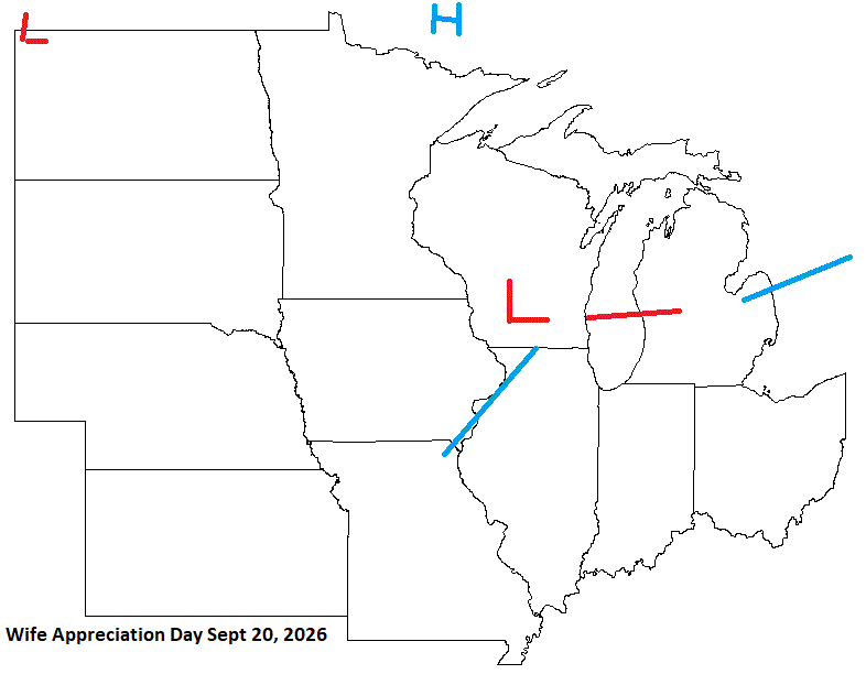
Wife Appreciation Day just before the Fall Equinox looks unsettled with some energy moving through the sub. Ok husbands, you know what to do today (I hope).
-
Reggie might be fun though
-
Midwest im guessing.. nothing seems interesting here
-

2026-2027 Super El Nino
GaWx replied to Stormchaserchuck1's topic in Weather Forecasting and Discussion
Thanks, Chris -Long range model winter forecasts have, indeed, tended to be too cold on average based on my recollection although the Euro has missed on both sides. So, I wouldn’t be shocked if 25-6 also comes in warmer than today’s forecast, but that remains to be seen. -But keep in mind that you essentially are showing a super Nino sample size of 1 (2015-6 done in August) since 2023-4 wasn’t a true super (RONI peaked at only +1.49). ONI had ~0.5C excess due to very warm surrounding tropical waters from GW inflating the ONI. -Also, other super Ninos had a fairly similar temp. pattern to what the NMME shows overall. -

2026-2027 Super El Nino
mitchnick replied to Stormchaserchuck1's topic in Weather Forecasting and Discussion
Nobody is forcing anyone to consider any model. But if someone posts a model's SSTA forecast, what's so wrong or unusual about posting it's resulting weather forecast. It's done all the time. -
2026-2027 Super El Nino
mitchnick replied to Stormchaserchuck1's topic in Weather Forecasting and Discussion
The weather is what counts, and I'm not seeing anything different than previous extremes being forecasted by the same models forecasting your "global climate disruption." In fact, there's yet to be an agreement on the resulting weather. -
-

2026-2027 Super El Nino
forkyfork replied to Stormchaserchuck1's topic in Weather Forecasting and Discussion
we're facing the biggest global climate disruption of our lives -

2026-2027 Super El Nino
LakePaste25 replied to Stormchaserchuck1's topic in Weather Forecasting and Discussion
Why would I even look at what models are showing next winter with more than a grain of salt when it’s only June? I am focused on how this is developing and summer analogs. I will check on that in October. -

2026-2027 Super El Nino
bluewave replied to Stormchaserchuck1's topic in Weather Forecasting and Discussion
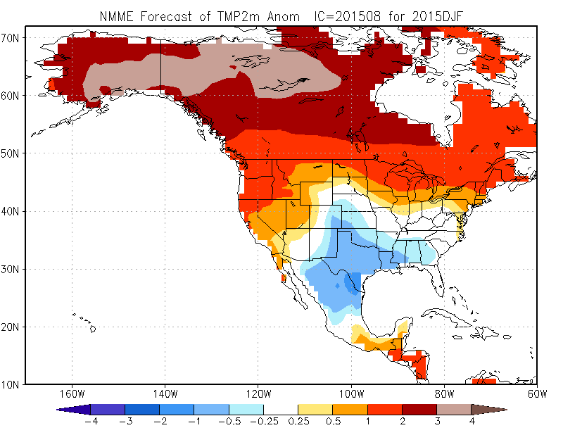
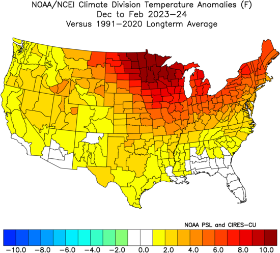
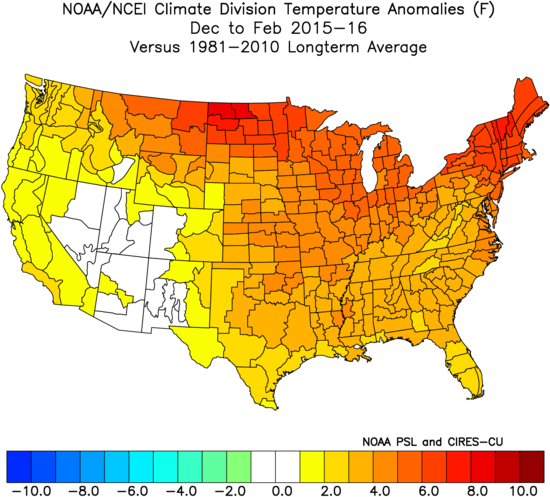
Those seasonal model 2m temperatures typically run way too cool especially with super El Ninos like we saw in 2023-2024 and 2015-2016. This has been the case with all the seasonal models. Even the forecasts issued in November were still too cool NMME DJF 2023-2024 long range forecast issued August 2023 Verification DJF 2015-2016 long range forecast issued August 2015 Verification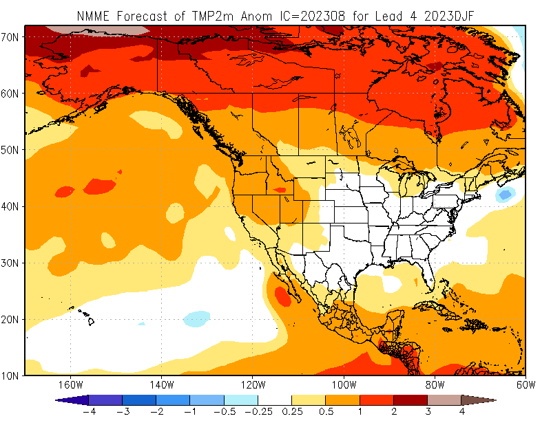
-
2026-2027 Super El Nino
mitchnick replied to Stormchaserchuck1's topic in Weather Forecasting and Discussion
I said weather in the east. -
2026-2027 Super El Nino
mitchnick replied to Stormchaserchuck1's topic in Weather Forecasting and Discussion
So you can post verbatim model conditions if they suggest a furnace but not if the same model suggests conditions otherwise? -
2026-2027 Super El Nino
GaWx replied to Stormchaserchuck1's topic in Weather Forecasting and Discussion
-Unlike Cansips, these NMME maps look typical/more believable for a strong Nino. -The strong Nino very typical wetness (starting as early as Oct on this run but I usually bank on the start in Nov) gives a lot of hope that the bad but somewhat improved drought in the SE will be mainly history by mid to late winter. - These maps are consistent with the El Niño winters that had one major to possibly historic SE US snowstorm like has occurred in many El Niños. -
2026-2027 Super El Nino
forkyfork replied to Stormchaserchuck1's topic in Weather Forecasting and Discussion
so post about it in your local subforum -
2026-2027 Super El Nino
mitchnick replied to Stormchaserchuck1's topic in Weather Forecasting and Discussion
Conditions on the earth a couple thousand+ miles from mby are meaningless to me except how they effect weather imby. -
2026-2027 Super El Nino
LakePaste25 replied to Stormchaserchuck1's topic in Weather Forecasting and Discussion
Yeah but this shiny looking map says I’m going to have near normal temps 6 months from now in december in a record breaking super nino -
Should be an interesting week of weather around here starting with cool and dry and the second half Hot Steamy with Severe Storms...
-

E PA/NJ/DE Spring 2026 Obs/Discussion
2wheelin replied to PhiEaglesfan712's topic in Philadelphia Region
What's causing this annoying cloud band slicing PA in half today (Monday)? -
2026-2027 Super El Nino
forkyfork replied to Stormchaserchuck1's topic in Weather Forecasting and Discussion
strongest nino in history and we're still on the backyard snow talk -
Looks like Canada got their wildfires out of the way for this year?
-

Mountain West Discussion
mayjawintastawm replied to mayjawintastawm's topic in Central/Western States
Front Range north of COS is in a Slight Risk for this afternoon, mostly for hail with 1" hail east of I-25. Time to drag the pots under the patio roof... -

Central PA Summer 2026 Discussion/Obs Thread
Itstrainingtime replied to Voyager's topic in Upstate New York/Pennsylvania
Fortunately, the forecasters had it dead wrong. It's incredible outside today! My temp was 68 at 8:00am, and now at 11:30am, it's only 69 with a refreshing breeze. I had a top wind gust of 61mph on Saturday. Tons of trees down and road closures between Maytown and Mount Joy. -
the storms locally on Saturday afternoon were the most destructive of the season, so far, (at least around the northern burbs of CMH). Out driving around for work today and lots of downed trees. A house on our street with moderate damage to the roof from a large tree going down. Once again, it always seems like our best severe comes when there's virtually no hype beforehand.
-

2026-2027 Super El Nino
snowman19 replied to Stormchaserchuck1's topic in Weather Forecasting and Discussion
No surprise in the EPAC. Super El Niño/++PMM at work. Explosive setup for a huge TC season…. -
Its all good. You may see some of the trees down along 416 on the left as you come up the hill from 207 if you come through Goshen depending on how quickly that clean up happens. You'll be within raiding range of my beer fridge when you tee off at 16. I'll let the maintenance guys know that you'll be around and if they see you walking through the maintenance yard towards my house to stop you at all costs! That said, It would be cool to set something up one day after you golf there for a couple cold ones on the deck.


