All Activity
- Past hour
-

September 2025 OBS-Discussion centered NYC subforum
bluewave replied to wdrag's topic in New York City Metro
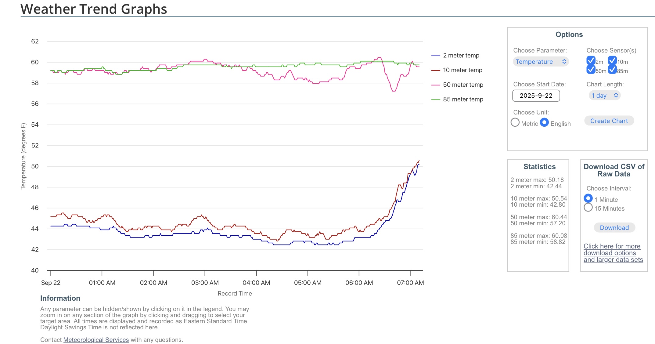
Those radiational cooling inversions are really shallow. The low was only 58° at 50 meters up. That’s what the urban areas experienced this morning due to UHI around NYC.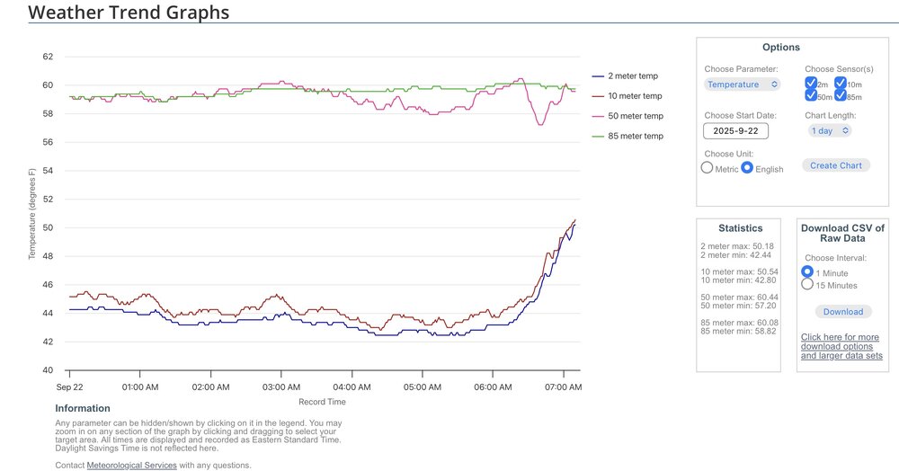
-
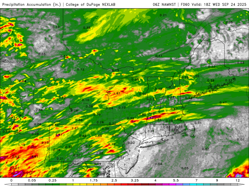
I'll be in Calvert Wed thru Sat staying with my dad and looking after pets while rest of family is out west for a wedding....including my nephew's SEVENTEEN chickens. It's easy when it's dry, but they told me it's a huge mess when it rains. Uh, I'm thinking I'm in trouble? Time to look for some mudder boots. QPF forecast looks juicy!
-
Bees are crazy this year! Both my daughter and I got stung though our clothing (she had a sweatshirt on!) earlier this month on a cool morning. I haven't had a bee sting in 35 years. Got me right in the gut too, super itchy for a couple days. I've also heard gasoline and a match will take care of them haha.
-

2025 Atlantic Hurricane Season
Michelle Davies replied to BarryStantonGBP's topic in Tropical Headquarters
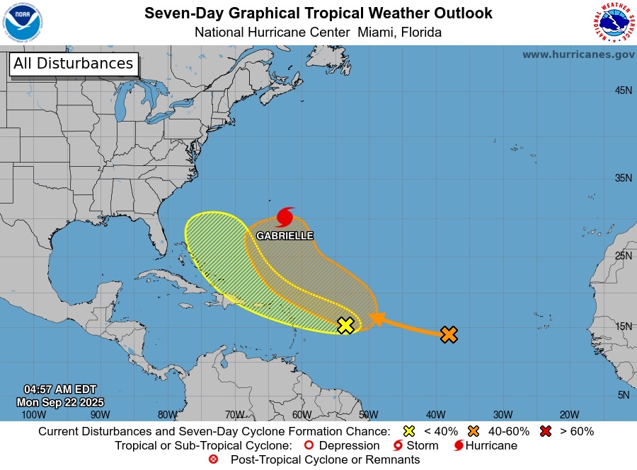
Now that mandarin is a cherry and that lemon is a mandarin if you check the latest NHC page -
Here is the possible NE slobberer 2. East of the Leeward Islands: A tropical wave located about 400 miles east of the Leeward Islands continues to produce disorganized showers and thunderstorms. Environmental conditions appear marginally conducive for slow development over the next few days as the wave moves quickly westward to west-northwestward at 15 to 20 mph. By the latter part of this week, the system is expected to slow down and turn more northwestward, and a tropical depression could form late this week when the system is over the southwestern Atlantic Ocean or near the Bahamas. Regardless of development, gusty winds and showers are expected to affect portions of the Leeward Islands late tonight and Tuesday. * Formation chance through 48 hours...low...10 percent. * Formation chance through 7 days...medium...40 percent.
-
Now 20/70! euro and GDM have a major fish from this 1. Central Tropical Atlantic: Shower and thunderstorm activity associated with a tropical wave located about midway between the Lesser Antilles and the Cabo Verde Islands has increased since yesterday. Environmental conditions are forecast to become more favorable for development by tomorrow, and a tropical depression is likely to form by the middle to latter part of this week while while the system moves west-northwestward to northwestward across the central Atlantic. * Formation chance through 48 hours...low...20 percent. * Formation chance through 7 days...high...70 percent.
-

September 2025 OBS-Discussion centered NYC subforum
uofmiami replied to wdrag's topic in New York City Metro
-
Doubt it would be a cane up here, waters are pretty chilly but maybe a glorified Nor'easter with gusty winds and some heavy rain and of course some high surf.
-
September 2025 OBS-Discussion centered NYC subforum
uofmiami replied to wdrag's topic in New York City Metro
46.0 in Muttontown & 48.1 in Syosset this morning. -
Who is David
-
Getting active
-
Most models are jacking CON-MHT. David got initialized into the 3k here though.
-
Dewy week after today
-

September 2025 OBS-Discussion centered NYC subforum
MJO812 replied to wdrag's topic in New York City Metro
59 here -
Everything is wagons north
-
This looks closer to 3" this week.
- Today
-
What started a few days ago as a 4-5 day 1.5"-2" soaker has already shrunk to a 3 day 0.75" event with as much soaking power as the Steelers. Soon I fear it will move to Bengal soaking levels. Sent from my SM-G970U1 using Tapatalk
-
The new map is horrid looking.
-
Yea there’s a factor of that too.
-
Welcome! I live near there (but we’re in Alexandria). What are your hobbies and then can help point you in the right direction. You can’t go wrong with exploring Old Town. Del Ray in Alexandria has a great strip of coffee shops, restaurants, etc.
-
September 2025 OBS-Discussion centered NYC subforum
bluewave replied to wdrag's topic in New York City Metro
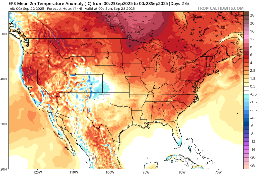
LGA remains the cool spot as we get a warmer pattern to close out the month. LGA….-1.8 BDR….-1.4 NYC….-1.1 JFK…..-1.1 HPN….-0.3 EWR…..0.0 SMQ….+0.1 ISP……+0.2 FWN…+0.6 HVN….+1.0
-
Some clear marks of UHI in once less populated areas.
-

2025 Atlantic Hurricane Season
NorthHillsWx replied to BarryStantonGBP's topic in Tropical Headquarters
I believe the switch in the northern hemisphere has just flipped -
Yeah but the areas that need the most will get the least. CT jackpot for rain.
-
40 for the low, felt great on the morning walk.


.thumb.png.4150b06c63a21f61052e47a612bf1818.png)

