All Activity
- Past hour
-
we watch!
-
I can’t. I just can’t.
-

2025 Atlantic Hurricane Season
BarryStantonGBP replied to BarryStantonGBP's topic in Tropical Headquarters
MJO forecast euro

-
The past two winters here in the lowlands have had some nice extended snowpack. Especially last season. I had more snowpack days in January and February than not. I had snowpack the entire month of January just about. Let's do it again!
-
I see CT is doing its thing by actually getting thunderstorms.
-
 93 degrees, windy but now a hot wind! Hoping these storms maje ut to nenj.
 -
 I won’t get a chance to wash my car today, so expect the storms to miss Staten Island
 -

Tropical Storm Erin - 45 mph - W @ 20
olafminesaw replied to BarryStantonGBP's topic in Tropical Headquarters
Big shift West on the EPS as well.thumb.png.e1a315df739fdcbd6dee573f0117b3d4.png)
-
I agree, if Erin can get going...she will take off.
-
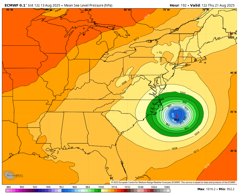
I'm just chewing on that run. I want to see some ensemble support. That said, you can see how quickly things go from well OTS (Newfoundland exception) to a very close approach with changes in the pattern over the US and Canada. The big ULL doesn't drop down as aggressively, the retrograding ridge over the US kind of meanders, and that allows the Atlantic ridge to push the door a little more. 00z 12z Now of course, because there's no cutoff in the GL region this eventually gets kicked, but that was modestly intriguing. SHIPS does foresee a better environment further west, and the organization of Erin is pretty good for its current intensity. I think it could really pop once it's able to get enough of a convective burst to get the engine going. That said, convection continues to fire on the southern side of the storm and the track continues to come in ever so slightly south of forecast. I still think a NE impact is fantasy land, but the door for a closer approach is not fully closed. Honestly, and this is also forever out, Erin could be good for a PRE somewhere depending on how that trough eventually evolves. Just food for thought. Also, this looks like a possible threat to Newfoundland. Been saying that for days now lol.
-

Tropical Storm Erin - 45 mph - W @ 20
wthrmn654 replied to BarryStantonGBP's topic in Tropical Headquarters
And that would be similar to the euro ai and icon solution. -
 Its 4 days with the possibility for more so not bad imo
 -
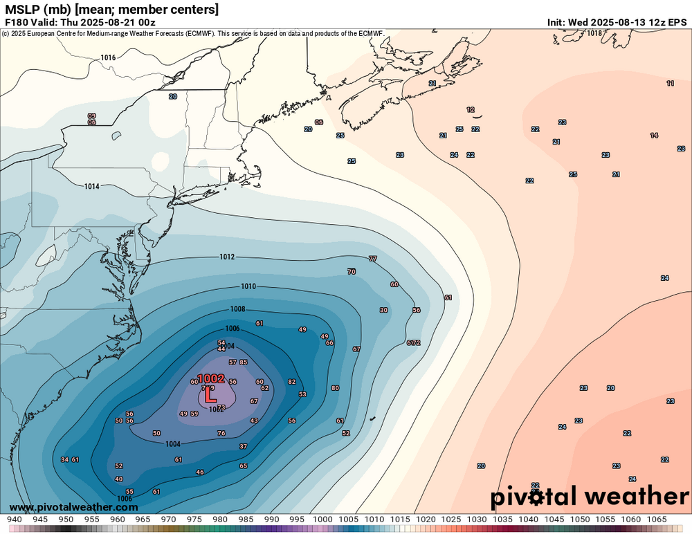
I will be willing to bet the euro OP is of the most western outlier when it comes to the EPS. but I will be curious to see what the mean is on the Euro. We may see some heavily skewed west members but willing to bet this is a major outlier
-
93/73/102 Why did the unnecessary flood watch talk about 6 inches of rain..can I ask the modeling for that
-
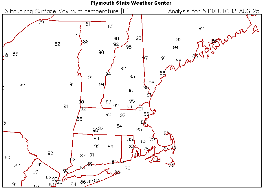
91.2° 3rd straight 96+ for CON
-
91° in Greenfield, but definitely feels more oppressive than yesterday.
-
There really should have been! It has been a crazy week!

-
It is raining!!!!!
-
91 at 1:20 and maybe going higher - 3rd heat wave here in 28 summers. Reasonable dews preventing huge discomfort, though full sun is still a furnace. Temps Mon/Wed: 91/60; 92/61; 91*/59. *so far. First 2 HWs also suggest bearable TDs: 8/02: 90/57; 90/61; 91/62 6/2003 (note correction of year): 91/52; 91/60; 90/64. Yeah. We have been noticing a lack of bats. White-nose fungus has decimated many species of bats, especially those which overwinter in hibernacula (e.g. caves). The fungus causes them to awake too early, depleting stored energy such that the critters don't survive hibernation.
-
Hopefully it rides north in future days
-
 People should be allowed to swim if they want. Lifeguards or not. Should we hire armed guards to make sure no one sneaks onto the beach after all beachgoers have been escorted off the sand when the lifeguards leave? If the the town put up appropriate signs of dangers then after that it's up to you if you want to ignore them.
 -

Tropical Storm Erin - 45 mph - W @ 20
GaWx replied to BarryStantonGBP's topic in Tropical Headquarters
12Z Euro: it doesn’t recurve til 75W and thus comes within 150 miles of NC! The OB are directly affected by its NW side. Gary Slezak, is that you?
-
Hopefully they'll have the power restored.
-
noticing alot of models start to crank Erin around Puerto Rico but are environmental conditions really going to favor that? Dry air/SAL I think is still going to be an issue and may even have some stronger shear to the north?


.png.d58f09bb984f3d0e1572d95ab1a422fe.png)


.thumb.png.4150b06c63a21f61052e47a612bf1818.png)