All Activity
- Past hour
-

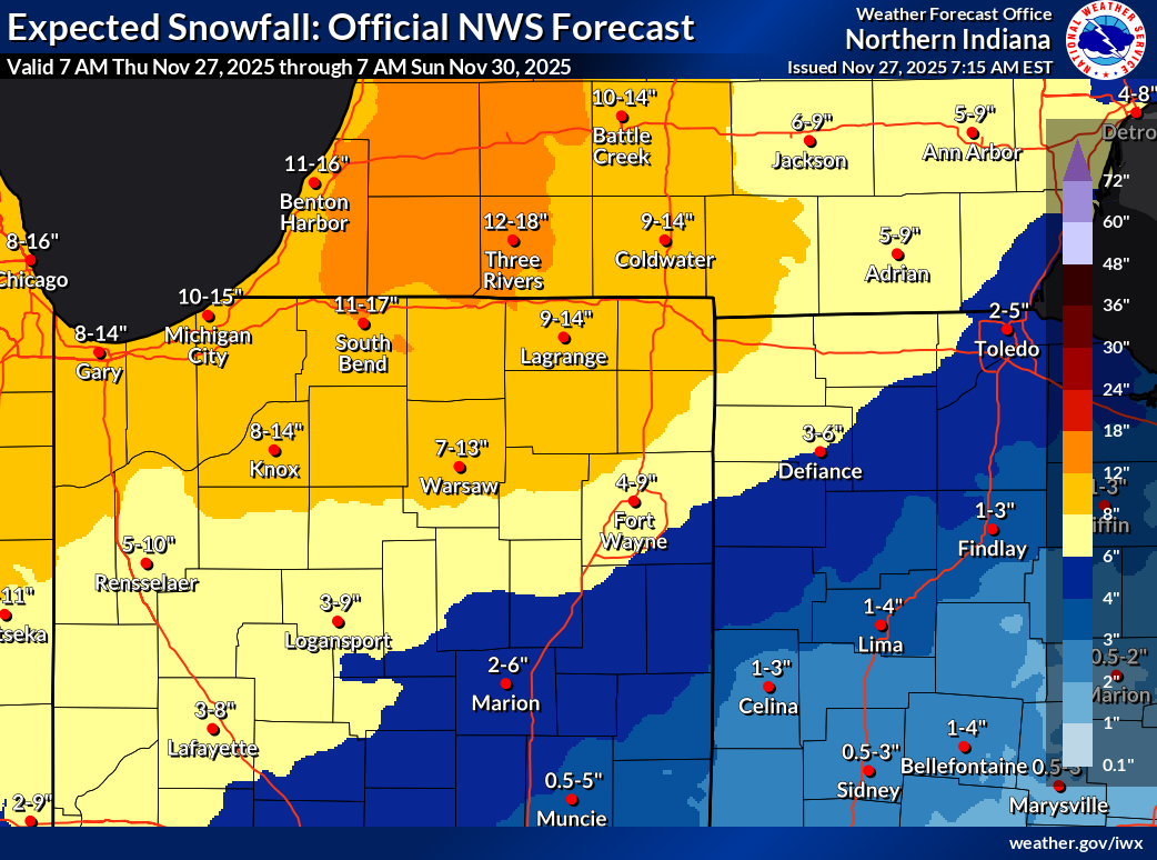
Nov 28-30th Post Turkey Day Wintry Potential
King James replied to Chicago Storm's topic in Lakes/Ohio Valley
Overdone? Still seems to be two camps with this one. Trends to me seem to indicate a pretty big event here but LOT and some posters here (guessing leaning into climo) are hedging their bet some. -

December 2025 regional war/obs/disco thread
Kitz Craver replied to Torch Tiger's topic in New England
Where is Runaway? Everything ok with him? -

December 2025 regional war/obs/disco thread
WinterWolf replied to Torch Tiger's topic in New England
I think you’re thinking of SWFE’s…those tend to come in quicker. As depicted, this is a coastal now, so I don’t know if the same thing applies? -
Favorable snow pattern for midwest/lakes and C/N New England. Lean towards cooler than normal further south but likely too warm for snow due to unfavorable storm track.
-

Nov 28-30th Post Turkey Day Wintry Potential
sbnwx85 replied to Chicago Storm's topic in Lakes/Ohio Valley
This includes today’s lake effect but c’mon now.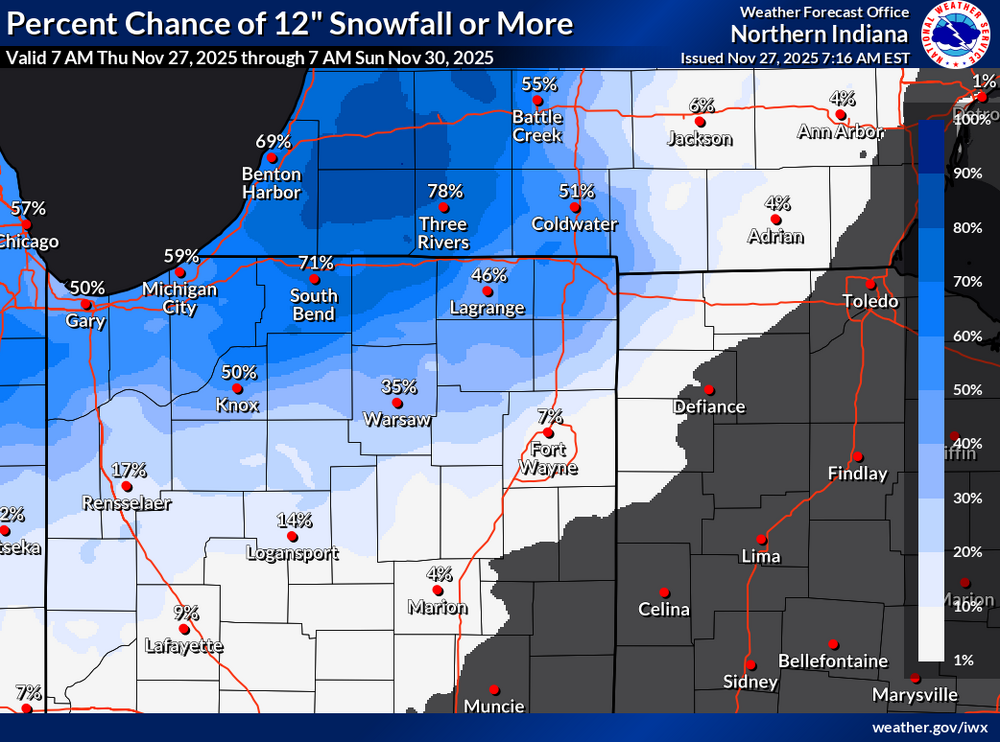

-
December 2025 regional war/obs/disco thread
WinterWolf replied to Torch Tiger's topic in New England
If it pans out, I like the idea that it starts during the day(visual in daylight is always nice), then goes into the night. But beggars can’t be choosers…. -
That run of the euro wasn’t that far off from hitting decent in most areas dc north. Hold that high a little longer or speed this thing up and its game time.
-
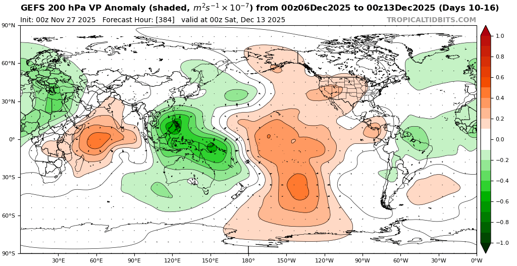
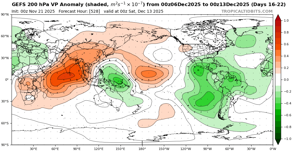
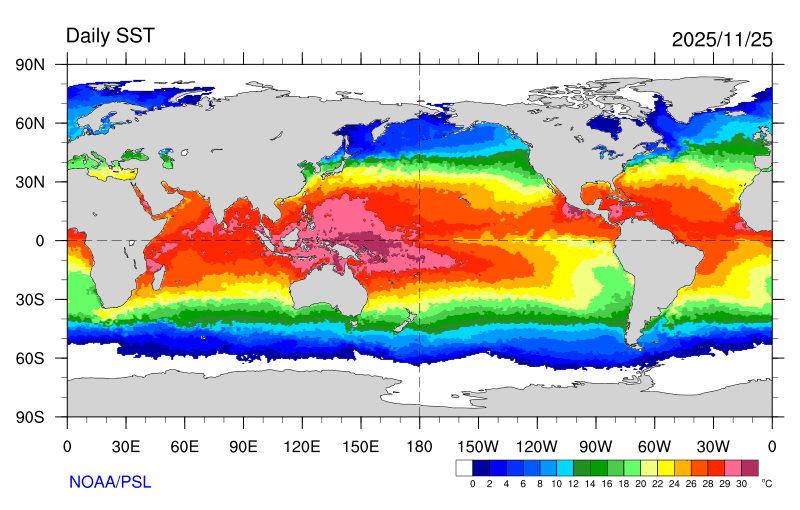
You can see how the long range models continue to underestimate the forcing near the Maritime Continent with the record warm pool there. So it interferes with the progression to a MJO 8 pattern. This is why the RMM charts appear to show a slowdown or loop in phase 7. New run Old run WPAC warm pool with expansive area of +28C to +30C SSTs


-
Well based on those stats that @psuhoffmanshared last year, all of us well south of the M-D line should be happy if you get snow while we shovel cold rain because it means good things for the rest of the winter
-

December 2025 regional war/obs/disco thread
HoarfrostHubb replied to Torch Tiger's topic in New England
Might start a bit later than that. I’m thinking noon/ish for a lot of folks (as currently modeled). But nobody knows… -
Ya seems these come in a bit earlier
-

Nov 28-30th Post Turkey Day Wintry Potential
Baum replied to Chicago Storm's topic in Lakes/Ohio Valley
I’d agree. If I could pull 6” on Thanksgiving Weekend would pretty much be a lifetimer for me. Note any other Chicago event you see for Turkey weekend turned to slop post event. That will not be the case this time. Real cold to follow allowing the snow to stick around. Big difference -
December 2025 regional war/obs/disco thread
Kitz Craver replied to Torch Tiger's topic in New England
Happy Thanksgiving all! What’s better than tracking a storm to kick off the holiday season, hope we can all cash in to some degree! -
Last nights Euro was the warmest run in a while and had some SE Ridge at times. More volatility eh?
-

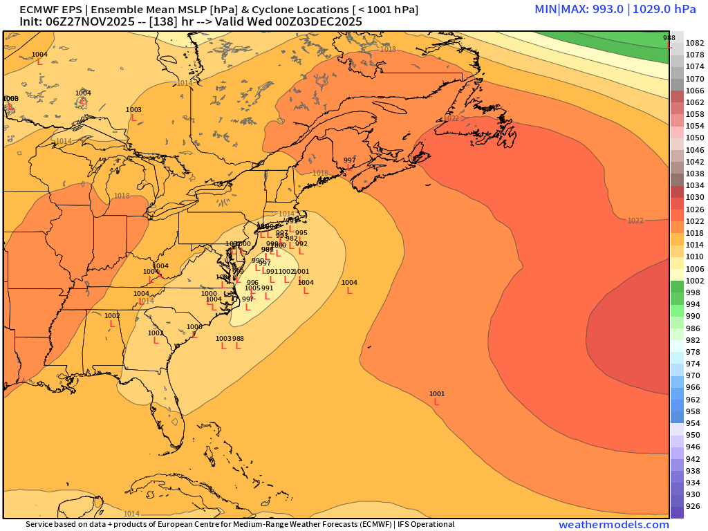
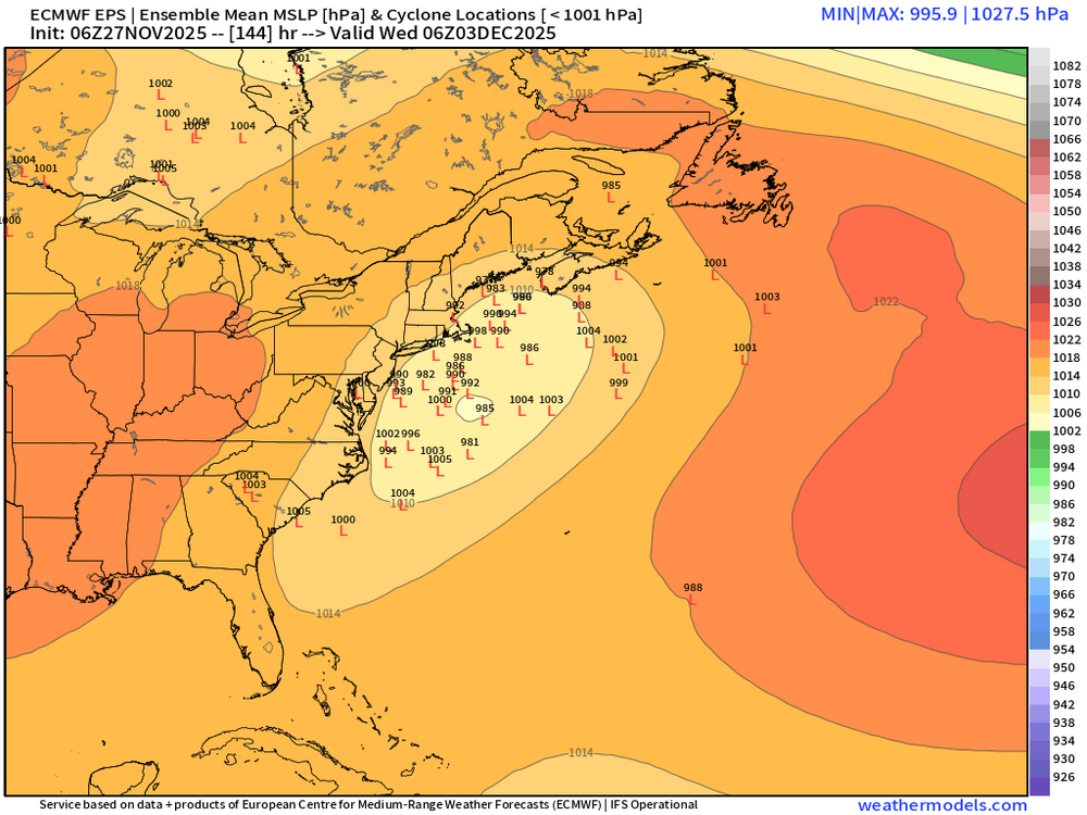
December 2025 regional war/obs/disco thread
Damage In Tolland replied to Torch Tiger's topic in New England
The storm is Tuesday . Comes in predawn . Today is 5 days -
@40/70 Benchmark As you and @Bluewave suspected…..
-

Nov 28-30th Post Turkey Day Wintry Potential
A-L-E-K replied to Chicago Storm's topic in Lakes/Ohio Valley
Call looking decent, temps and light rates def gonna be an issue -
Nov 28-30th Post Turkey Day Wintry Potential
King James replied to Chicago Storm's topic in Lakes/Ohio Valley
LOT hasn’t backed off the idea for rain/snow mix in my area for a time while WGN has been consistent with 8-10 for my area. I know our boy Tom isn’t behind the desk but I love when WGN weather doesn’t budge as the storm closes in. -
December 2025 regional war/obs/disco thread
WinterWolf replied to Torch Tiger's topic in New England
And some solid storms in there too… -
Would like to see model consistency inside of 5 days; if we still see similar runs come Saturday I would think it’s game on!
-
Thanksgiving prevails... Create new family memories and think about those who cannot be with us. Still contemplating a thread for Friday... I think there will be wind gusts to 40 kt at all the airports, but may be will fall short by 3KT. Marginal except if you have no power. Also even though its not in most forecasts, I'll be looking for many flurries in NYC metro Fri afternoon.
-
Happy thanksgiving folks! Going to be a nice cooler day today! Cheers! .
-
06z EPS looks pretty nice. Still a ways to go though.

-
Thanksgiving prevails... Create new family memories and think about those who cannot be with us. I think Dec 2-3 will need a thread for first measurable sleet-snow NYC CP with a potential moderate snowstorm I84 corridor with coastal flooding Late Dec 2, early Dec 3 high tide (lunar abnormal). Also, Dec 7ish is dependent on whether the initial short wave is stronger per the EPS or whether the GEFS trailer into the Plains states prevails. In any case this looks to be an interesting two weeks of stratwarm aided early winter opportunities. Also even though its not in most forecasts, I'll be looking for many flurries in NYC metro Fri afternoon, isolated brief dustings inland from I95.
-
You’d like to see the low north of New Foundland a little south to hold in the high from retreating as much. It would give us more wiggle room on the track.