All Activity
- Past hour
-

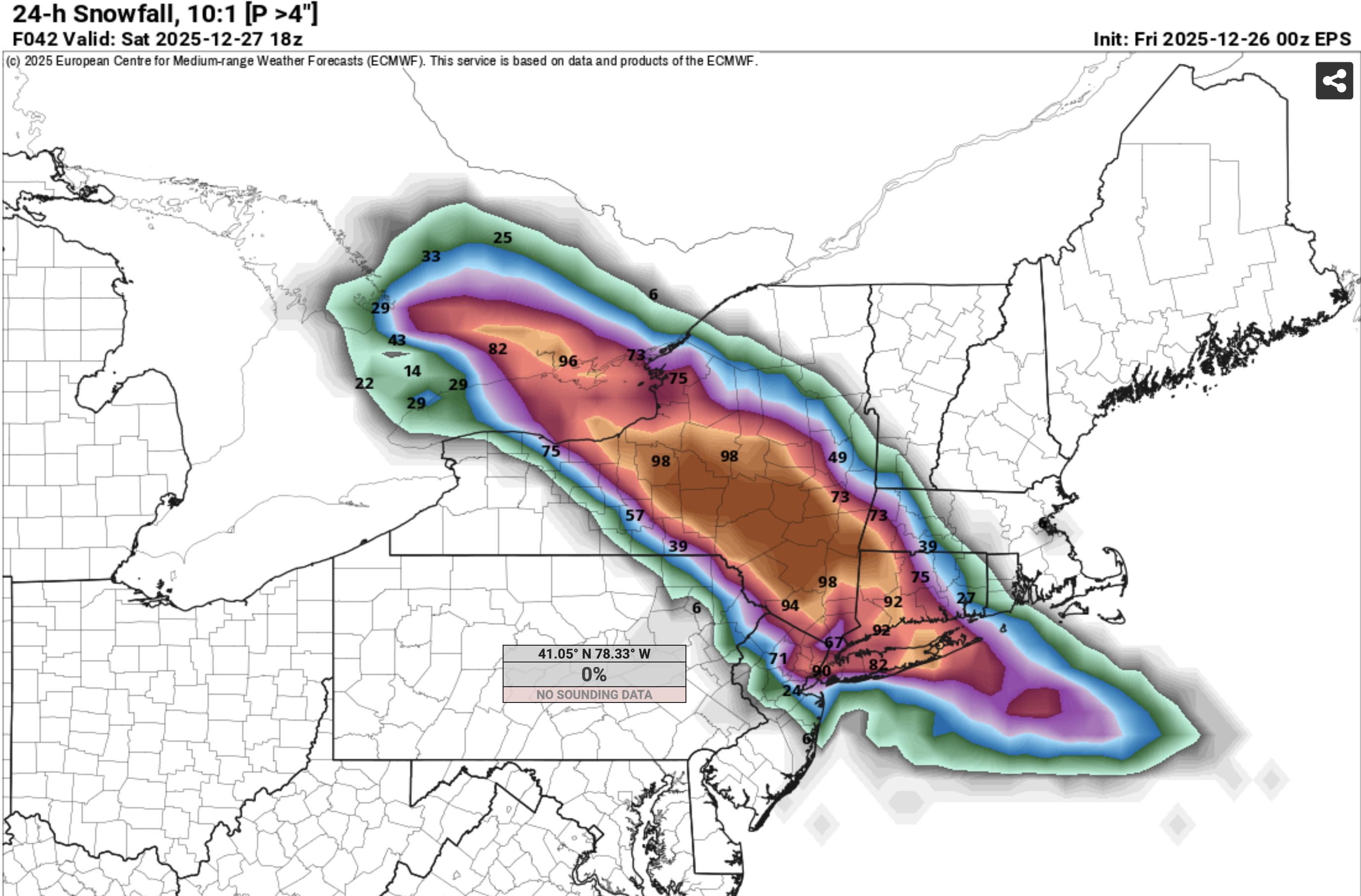
Wounded Duck Strikes Back: Dec 26 & 27th Winter Storm Obs
TauntonBlizzard2013 replied to WxWatcher007's topic in New England
We wait, hoping to score 3-5. Scott want to chime in with some thoughts for this area up towards him? -

2025-2026 ENSO
40/70 Benchmark replied to 40/70 Benchmark's topic in Weather Forecasting and Discussion
Still mainly above average for the most part. -
I wouldnt be to concerned with a ice storm,maybe next winter,We in Mid Tn and W/TN get ice storms from a NINO not NINA,plus this a more East based LaNina,the east gets all that and more than likely more snow
-
And that being said since the system is headed more SE now the sleet line should stop advancing-it’s already headed back west a little and snow should refire/linger through a good part of overnight. Still quite a bit of precip to go on the short range modeling especially from the city and east.
-
CPK <4" streak is going to continue
-

Wounded Duck Strikes Back: Dec 26 & 27th Winter Storm Obs
MJO812 replied to WxWatcher007's topic in New England
Snowing pretty good again but it was sleeting before. Not alot. -
this thing will be over by midnight lol
-

OBS/Totals for 12/26-27 Storm
SomeguyfromTakomaPark replied to jm1220's topic in New York City Metro
HRRR has the dry slot filling in and gives northern westchester 0.49 QPF after 1z. Perhaps it’s smoking crack but I pray it’s not. -
It reads the 9000 ft near 32F TT very well.... repeatedly. While NAM has lots of variability in its modeling of this storm... when you see it have ice, be cautious. Those that get my FB messages knew of my concern in NJ/PA. This is not a classic storm... no closed low at 850MB. Banding into good snow growth in the cold air produced. se NYS/CT/parts of LI. still a little hope for tail end southward rotate 1-2" down to I80 but the models overall were too snowy in ne PA/nw NJ including the SPC HREF big time. Euro prob for 4"+ seems pretty good. What I used this morning at 5s30A. Pattern still good for us into January. Good night.

-

Wounded Duck Strikes Back: Dec 26 & 27th Winter Storm Obs
Modfan2 replied to WxWatcher007's topic in New England
Still waiting on in the 395 corridor/RI Line….Dry air winning -

Boxing Night Snow/Sleet/Ice Dec 26-27 Storm Thread/Obs.
shadow_ replied to Mikeymac5306's topic in Philadelphia Region
Think it finally changed to a very fine light snow now...but by looking at radar it's not going to add up to much maybe a dusting to cover the ice. -
I think the north fork will have a shot as the LI jackpot zone
-
It’s a blind squirrel that found a nut. But there were red flags today especially that it could be a sucky precip shield heading into the city and the best WAA snow would overshoot to the NE.
-

Wounded Duck Strikes Back: Dec 26 & 27th Winter Storm Obs
weatherwiz replied to WxWatcher007's topic in New England
yeah that back edge approaching quick. folks under the banding though are good for a bit though -

Central PA Winter 25/26 Discussion and Obs
Jns2183 replied to MAG5035's topic in Upstate New York/Pennsylvania
It's also horrendous out. Some guy just spun out on 11/15, crossed lanes, got hit. Luckily other person was going very slow Sent from my SM-S731U using Tapatalk -

Wounded Duck Strikes Back: Dec 26 & 27th Winter Storm Obs
FlashFreeze replied to WxWatcher007's topic in New England
snowing quite hard, tiny flakes but accumulating fast, no wind 1 inch so far. -

Wounded Duck Strikes Back: Dec 26 & 27th Winter Storm Obs
The 4 Seasons replied to WxWatcher007's topic in New England
how much in Brooklyn so far and whats the current wx -
The curse lives!
-
Same here however back to snowing moderately
-
why are they discontinuing it? Nam is good i guess. This is going to be a major bust!
-
Wounded Duck Strikes Back: Dec 26 & 27th Winter Storm Obs
weatherwiz replied to WxWatcher007's topic in New England
was waiting for your post! This bodes well for me -
2025-2026 ENSO
40/70 Benchmark replied to 40/70 Benchmark's topic in Weather Forecasting and Discussion
Book it- -
No kidding; I was never sold on Tua even coming out of college. I don't question his heart but he just doesn't have the body to take NFL pounding, and it seems as if he just doesn't have the skill to do the reads if his first target is taken away. But he had that good year at just the right time and they threw ridiculous money at him. I was kind on interested in getting a fan's eye view of Lamar though. For an outsiders view it seems as if he is stagnating. Maybe it's just the injuries or the line play or a combination. I wonder if he might benefit from a change of scenery.
-

Wounded Duck Strikes Back: Dec 26 & 27th Winter Storm Obs
Boston Bulldog replied to WxWatcher007's topic in New England
Just drove from Greenwich CT to Port Washington on LI over the past 90 mins or so, and the results are excellent for SNE weenies on the NE edge. It was absolutely dumping in CT and Westchester. Approaching the Bronx, the distinct sound of rimed flakes appeared, it was clear warm nose is ferocious and ripping north. By the time I reached the Throgs Neck Bridge, it was all sleet. While planning the drive I only expected a hint of sleet by the time I reached my destination. The forecast is going to bust big time down here. This dead duck is going to come in well north -

Wounded Duck Strikes Back: Dec 26 & 27th Winter Storm Obs
ineedsnow replied to WxWatcher007's topic in New England
Westfield whitened already https://www.westfieldwebcam.com/


.thumb.jpeg.f5c6ba9d911ec96b3b124f8606aee58e.jpeg)