All Activity
- Past hour
-

E PA/NJ/DE Autumn 2025 Obs/Discussion
RedSky replied to PhiEaglesfan712's topic in Philadelphia Region
Forecast from PA Weather Action Slightly above normal from these fellers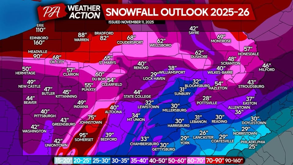
-

November 2025 general discussions and probable topic derailings ...
WinterWolf replied to Typhoon Tip's topic in New England
He likes to be neggy alot. Only has to hold for another 250 hrs…we can do it. -
Updated my records in the other thread. Leader in the clubhouse until @alex and @powderfreak add in their numbers which are probably 3x mine already!
-
GFS-AI? where can I access that?
-

November 2025 general discussions and probable topic derailings ...
MJO812 replied to Typhoon Tip's topic in New England
And once again you are dismissing the projected pattern . -

November 2025 general discussions and probable topic derailings ...
CoastalWx replied to Typhoon Tip's topic in New England
Just need to hold for 300hours. We can do it. -
That doesnt mean this winter will not be good. Its only November 17. Jeez people are already jumping off ledges.
-
You dont need a positive PNA to snow to the coast if you have other teleconnections in your favor ( im talking about further north you go ) You seem really down on this winter
-
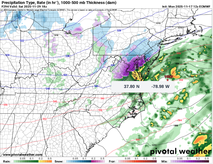
Both the 12z Euro-AI and GFS-AI try to dump a decent shot of polar air on the CONUS during Thanksgiving weekend.
-
Early Dec looks bad for the coast, no +PNA in sight so things will cut. Remains to see what mid-late will bring.
-
A link to all the "credible" model RMM forecasts are at this link fwiw: https://www.stormsurf.com/page2/links/mjo_phase.html
-

November 2025 general discussions and probable topic derailings ...
mreaves replied to Typhoon Tip's topic in New England
My friend in PI said they got 8". -
12z Euro was nice. Temps are around 32-35 so rain/snow mix.
-
November 2025 general discussions and probable topic derailings ...
MJO812 replied to Typhoon Tip's topic in New England
Check again Euro pops a small coastal on the 30th and brings some light snow to NYC lol -
end of 12z Euro looked kinda cool, temps at DCA and BWI were like 32-35 so rain/snow mix
-
November 2025 general discussions and probable topic derailings ...
WinterWolf replied to Typhoon Tip's topic in New England
That will change again. And that’s for T Giving day. The week after is when we start paying attention. -
It looks like it might have been a bust to my NW, but we produced in SLK. When I woke up yesterday morning and we already had an inch on the ground with temps falling, I knew it'd be a good one. Of course, had to leave before the storm wrapped up lol. Already over a foot so far this season. Still some light snow there at 25.2 degrees.
-
Probably real unlikely that this winter will be as bad as 22-23, that was one of the worst in the last 30 years in the NYC metro area, 22-23 ranked right up there with 97-98, 01-02, 07-08, 11-12 and 19-20. The clue to look for when there’s a La Niña is what December does….if December ends up with below normal snowfall, especially if November has no snowfall, followed by a below normal December, that’s a very, very bad sign. Usually the kiss of death for the remainder of winter in the NYC metro area
-
perhaps this is an over-polarization, especially for central park, but for Baltimore and points south I can tell you we treat every snow event like gravy.
-

November 2025 general discussions and probable topic derailings ...
Typhoon Tip replied to Typhoon Tip's topic in New England
39/20 in full sun ... it's a winter atmosphere today at least. If there were a snow pack in situ and upstream, we'd probably be stuck closer to freezing. -
 Unrelenting wind . Just roaring
 -
Forecasted low of 50, actual low of 37. They missed that one by a mile.
-
We ended up with incredible fall colors but they were all gone by the time the snow hit last Monday. They had about a week of vivid peak.
-
There has not been sufficient length of time. Many indexes are offered and even created but are dubious. We do know the negative NAO and AO remain big. Enso is not as strong a determinant as it was 15+ years ago. Pacific Ocean warmth cannot flood the nation and up into Canada. DC needs MillerAs and not phase job/transfer crap. We can get decent overrunning but the secondary rarely does anything for us . Mongolian high pressure sets us up well.
-
Looks like Jay’s claiming 34” at the summit for the cycle that ended last Friday (Based off them reporting 21” over the last 48 hours). Coverage up there was great on Saturday, but I would subtract 10-12” from that for sure. It’s not like it was 3 feet of blower that condensed down, the snowpack was dense and surfy with little room for compaction. Love Jay but these reports seem to get increasingly ridiculous. 55” in a drift up against the Tram House perhaps?


