All Activity
- Past hour
-

White Christmas Miracle? December 23-24th
Sey-Mour Snow replied to Baroclinic Zone's topic in New England
ya Euro op and AIFS are a solid 2-4" area wide.. Not as juiced as 6z or GFS.. -

December 2025 regional war/obs/disco thread
mahk_webstah replied to Torch Tiger's topic in New England
That might not be too bad up here. I think that’s the pattern we had was it in 2023? We ended up with close to 100 inches here but with a lot of wet, heavy storms where we were right on the edge and you were raining down south -
12z Euro Op is similar
-

White Christmas Miracle? December 23-24th
Damage In Tolland replied to Baroclinic Zone's topic in New England
Gfs / Icon seem to have the better idea overall . Makes sense -
White Christmas Miracle? December 23-24th
Sey-Mour Snow replied to Baroclinic Zone's topic in New England
Loading early Tuesday now, it's colder and SE, maybe a hair less amped.. -
December 2025 regional war/obs/disco thread
mahk_webstah replied to Torch Tiger's topic in New England
But if I close the shades, then won’t I be unable to look at the 2 to 4 inches of snow that will fall on Tuesday? -

White Christmas Miracle? December 23-24th
CoastalWx replied to Baroclinic Zone's topic in New England
Probably for him -
The warmth over Central US is very impressive, akin to the very warm Christmas we had here in December 2014 and December 2015. This is one of the few times where you would want a pacific jet extension to force storms into the west, which will roll the ridge through the east US and then maybe we can reset from there. But until that omega ridge subsides over Central US, CONUS is almost completely void of cold and snow. Horrendous
-
White Christmas Miracle? December 23-24th
Sey-Mour Snow replied to Baroclinic Zone's topic in New England
WB isn’t loading, good for all? Same as 6z? -
White Christmas Miracle? December 23-24th
Sey-Mour Snow replied to Baroclinic Zone's topic in New England
Ya AIFS ticked SE then IVT into Maine -
12z Euro looks good.
-
This would be the death knells for Winter 2025-2026. Prime time when temps are the coldest, and there is a trough in west Canada and a dip in the jet stream across west/central US, and a ridge over east US. And remember, this is a smoothed ensemble mean. Once we get closer to the date, it won't be as smoothed and the differences between the trough in the west and the ridge in the east would likely be much greater. While the -NAO continues to improve, all other teleconnections remain where we don't want it, including a deepening -PNA. Without help from the PNA and the pacific, the -NAO will be almost meaningless
-
White Christmas Miracle? December 23-24th
CoastalWx replied to Baroclinic Zone's topic in New England
Yeah PWM love there. Still like the look here overall. -

Possible Light Snowfall (1" - 4") on Tuesday Dec 23
Stormlover74 replied to Northof78's topic in New York City Metro
Not sure I get the reasoning behind why an inch of snow is not possible in this scenario -
I have never heard of ever needing a special Jebman-issued STATE OF THE SNOWPACK report for a place such as Palisades Tahoe. STATE OF THE SNOWPACK Issued Sat 9.12am local PST 20 DEC 2025 It's true I am no veteran of the Tahoe Resort. But never in my born days have I ever seen the Infamy at Tahoe, at the 8200-foot Scope level, that I witnessed today. Several inches of near-clear SLUSH! I had to ask myself, is this the Mid Atlantic with Lucy doing her usual, or could it truly be Palisades Tahoe stuck in a super Interglacial? This, is FAR WORSE than the Ravens losing every game for five seasons, even with all of the best acquisitions they could ever get!! What did they get last night at Tahoe, white meteors? I have seen all their cameras which now work. Absolute Bedlam. Grass. Bushes. This looks like July at the Resort. Might as well have hikes and mountain bike races all "winter". I was horrified. There are a few places they tried so hard to develop something to ski on with artificial snow, but it has obviously been so damn mild right up to now, that the state of the non-existent snowpack is a Mean One, and Nature has been and is one hell of a ferocious Grinch! Christmas is five days away, and I am sorry to say Tahoe will have a Green Christmas! Or Brown. Anything but white. There is no Christmas miracle this year. Even Santa is staying away. The low tide obstacles would rip up his ski runners on his famed sled. Skiers don't know what to do! Some are so desperate for snow they are going to Antarctica! Hey, they got mountains! They got snow too. It's just a little bit colder than they are used to lol. The State of the Snowpack at Palisades Tahoe is something hellishly worse than horrible right now. Even the storms are rainy or sloppy slush snow. And the temps are bad, 35 degrees? At 8000 feet? There is no snowpack at Palisades. I don't even know why I try. I don't even know why I care. It's all for nought. I never ever even imagined in my worst nightmares, a fate such as this for poor Tahoe, a snowless wasteland that can't even hit 32 degrees at night with a megastorm with 14 inches of water, that's gonna all fall as pure water, for a week. The Palisades may all get washed away by New Years.
-

Digital Snow/Ice Thread 2025-2026
WinstonSalemArlington replied to WinstonSalemArlington's topic in Southeastern States
-

White Christmas Miracle? December 23-24th
dendrite replied to Baroclinic Zone's topic in New England
EuroAI really likes SW ME. -
Opposite here. When it slotted in between the winds were fierce. There was at one point a downpour that came through and it was a legit tropical storm.
-

December 2025 regional war/obs/disco thread
RUNNAWAYICEBERG replied to Torch Tiger's topic in New England
Pray this fades over time: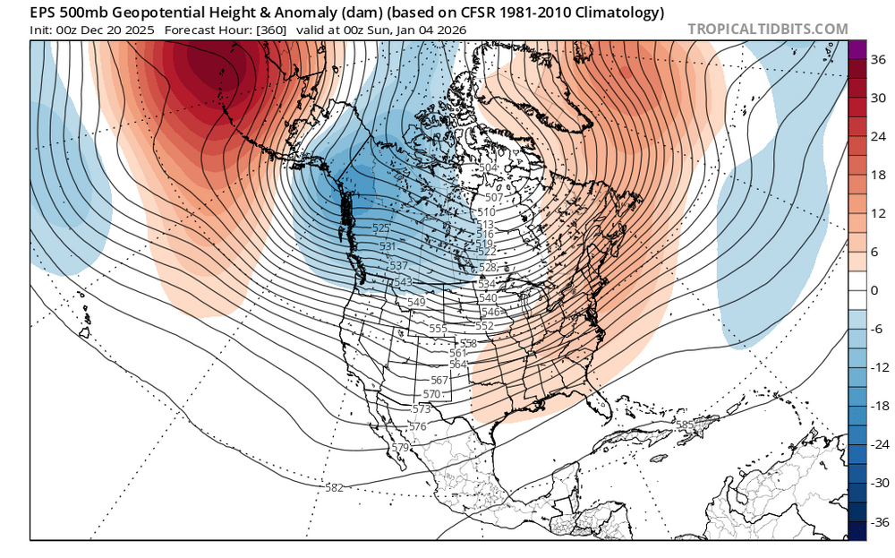
-

December 2025 Short/Medium Range Forecast Thread
GaWx replied to John1122's topic in Tennessee Valley
22, 96, 84 -
Mid to long range discussion- 2025
WinstonSalemArlington replied to wncsnow's topic in Southeastern States
Nationally, the hottest Christmas in modern history -

December 2025 Short/Medium Range Forecast Thread
jaxjagman replied to John1122's topic in Tennessee Valley
Do you know off hand what years those were with a EQBO,i know last Jan was a WQBO? -

Possible Light Snowfall (1" - 4") on Tuesday Dec 23
coastalplainsnowman replied to Northof78's topic in New York City Metro
Not to mention, being December 23rd it will be practically the best sun angle possible, especially at night. -
Columbia east — 25.4° morning low. Noon 33°.
-

White Christmas Miracle? December 23-24th
40/70 Benchmark replied to Baroclinic Zone's topic in New England
Tough to buy the GFS at this point, but something to watch....for now, consider that the spiked-eggnog outcome.


