All Activity
- Past hour
-

December 2025 regional war/obs/disco thread
weatherwiz replied to Torch Tiger's topic in New England
I just hope its right but the models have struggled greatly within this domain. -
Grass turning white
-
I’ve been looking at that map for more than 5 years now.
-
GFS and Euro couldnt look more different for Christmas Eve
-
For the first time, mostly snow now
-
Changing over earlier than expected in norfolk. Good sign for you
-
That’s a good visual of how the arctic jet strengthens from Siberia to AK/N Canada as that WPO block strengthens. In addition, the stronger WPO block helps force that vortex down south of Aleutians which helps pump the PNA ridge…I think it was @Typhoon Tip who talks about their inverse correlation with a small lag.
-
Nothing on roads or grass, but my 3rd cartopper
-
I really had not looked that far out as we have had a few events in the short term here and another one tomorrow night into weds.
-
27/3 now. Arctic airmass. good for the utility companies and ski resorts up north. Otherwise useless
-
You changed over earlier than expected. good sign for our NC friend
-

December 2025 Short/Medium Range Forecast Thread
Daniel Boone replied to John1122's topic in Tennessee Valley
Didn't last long and ended as a mix. It was pretty heavy for a few minutes. 0.05" from it melted in gauge in about 20 minutes. -
33 and larger flakes now.
-

Richmond Metro/Hampton Roads Area Discussion
chris624wx replied to RIC Airport's topic in Mid Atlantic
Down to 35F! Flakes getting bigger too! -
December 2025 regional war/obs/disco thread
weatherwiz replied to Torch Tiger's topic in New England
I guess this is the feature to watch over the next day or two (Coming out of the Aleutians). How this evolves in the next 48 hours will likely tell us whether the ridge will amplify or not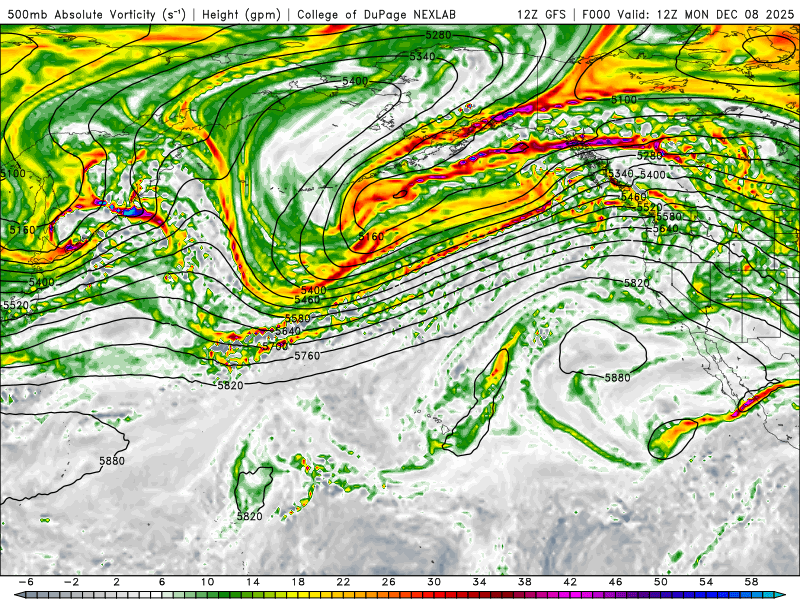
-

Richmond Metro/Hampton Roads Area Discussion
Dick_LeBoof replied to RIC Airport's topic in Mid Atlantic
Precipitation shield is really filling in nicely now from the south. Looks like the Richmond metro is about to get a heavy band. -
Deck lowering and flattening out, heaviest rain of the day despite nothing showing on radar. Hoping for some last minute magic.
-
A lot of these solutions are actually in a historically good spot for D6. The key is the trend…if we a slowly amp that ridge a little more, could be a solid event for a chunk of New England…esp southeastern 2/3rds which would include your area. What we don’t want is to see the trend in the ridge regress again.
-
Flurries now
-

The Monday wintry event potential (12/8/25)
NorthHillsWx replied to GaWx's topic in Southeastern States
CC line directly overhead now and just like that snow is mixing back in. 37.9 so I doubt we get low enough for much to stick, sadly -
Yep, temp and rates seems to have found a sweeter spot downtown now. Awaiting, the HR liability email, sending folks home soon.
-
how many inches does euro show for white plains, ny
-
December 2025 regional war/obs/disco thread
weatherwiz replied to Torch Tiger's topic in New England
I think the framework the follow up wave sets up is way more important than worrying about whatever the ridge in the West will do. This how the west ridging will unfold game the last few years has done absolutely nothing. We've countless times seen models trend well with that inside 96-120 hours...only for a total slap back in the other direction, even inside 72 hours. I am willing to bet by 12z guidance Wednesday, we see guidance scale back with that ridging. -

Richmond Metro/Hampton Roads Area Discussion
snowdude replied to RIC Airport's topic in Mid Atlantic
1PM: Snow really picking up in Midlothian. Many roads have finally given up and are now snow covered. -
I had to go look and it has 0.4-0.75" or so qpf on skynet in SNE out towards the cape but i'm talking the 15th.