All Activity
- Past hour
-
Yes there is, the AO looks to go positive but it's only temporary then return negative or neutral state within the next two weeks. The weeklies also keep an negative EPO which did well last winter.
-

December 2025 Short/Medium Range Forecast Thread
Carvers Gap replied to John1122's topic in Tennessee Valley
The 12z Euro deterministic also kicks out the energy out of the Southwest. The EPS is a little slower to do so, but I am going to guess it does the same. Both the 12z GEFS and EPS have a formidable cold look now. The SER flexes are short lived. Just file this one away for later used. I would say 75% chance that what we saw yesterday was feedback across all modeling. It caused havoc downstream from that. I would suggest modeling in the d8-14 is still in the process of correcting. -
I always have hard time realizing that people are illogical. It like really evokes some nasty stuff when warm forecasts are mentioned, for what I would say is a majority.
-

2025-2026 ENSO
Stormchaserchuck1 replied to 40/70 Benchmark's topic in Weather Forecasting and Discussion
Actually the 12z GEFS looks completely different from the 0z EPS over the N. Pacific. It actually has a trough in the gulf of alaska where the EPS has a ridge. EPS has been doing better so far, but it's an interesting split. I would guess the 2 models are handling the MJO differently? -
2025-2026 ENSO
Stormchaserchuck1 replied to 40/70 Benchmark's topic in Weather Forecasting and Discussion
There is a lag -
December 2025 Short/Medium Range Forecast Thread
Carvers Gap replied to John1122's topic in Tennessee Valley
The 12z Euro has correct as well. Storms are kicking out of the Southwest as one would expect. Now that modeling is getting that fixed, we should see some downstream corrections. I would expect for something to track pretty soon. -
Seems like some utter nonsense talk about a possible AO and positive NAO . A major SSW favors, negative AO and negative NAO phases.
-

November 2025 general discussions and probable topic derailings ...
George001 replied to Typhoon Tip's topic in New England
I’m not entirely sure, but I’ve heard that guidance struggles the most during seasonal transition periods and during la Nina’s. The struggles during La Niñas I would think is because they are northern energy dominant, and models struggle the most with energy originating from the north as it’s very sparsely populated up there. We are currently in a seasonal transition period and La Niña conditions are present, so I would expect these struggles to continue. -
2025-2026 ENSO
Stormchaserchuck1 replied to 40/70 Benchmark's topic in Weather Forecasting and Discussion
Alaska is a big spot. Neutral or negative H5 is going to give you a warmer pattern pretty far north. If the ridge stays over Alaska (probably unlikely) the northern areas will be cold. I'm mostly talking about Dec 6-7-> -
0.3" here
-
Why be negative? Things change, you have to be able to change with it. "The MJO forecast way out in time" has done so poorly as a forecasting tool over the years.
-
2025-2026 ENSO
Stormchaserchuck1 replied to 40/70 Benchmark's topic in Weather Forecasting and Discussion
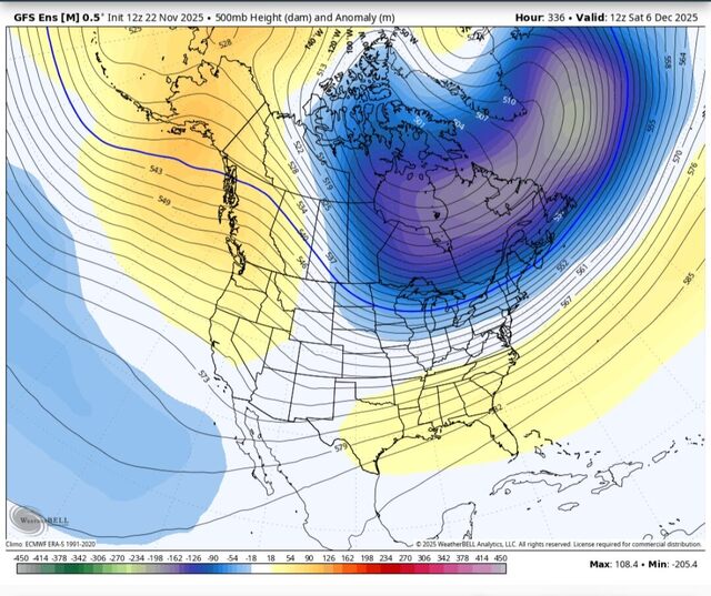
That's a +400dm mean ridge over Alaska for a 7-day period. Not really the same as the 1 panel you posted above. We are going to get a -EPO period but it's not going to be as strong or sustain like 2013. -
 .22 here. Sunny and warm now We lights
 -
Take the ops with a grain of salt
-
Amazing how that classic DT typo from years ago lives in infamy.....forever!
-
But it was a glorious week lol.
-
Don't tell them Eric Webb is getting excited about early December snow... for New Mexico
-
December, 2022. People were all but guaranteeing a December, 2010 redux with textbook KU’s bombing up the coast and the I-95 corridor getting dumped on. It was even called a historic setup by many and we were told to “buckle up, get sleep now, it’s coming”. The hype was off the charts for the better part of 2 weeks….
-
December 2025 Short/Medium Range Forecast Thread
Carvers Gap replied to John1122's topic in Tennessee Valley
I think the multiple cutoffs to Baja and/or Southern Cal....was an error. The GFS has a bias to be progressive, but because of that it will work this out more quickly. The 12z gfs and ensemble matched the 6z run. The CMC is still coming around. In fact, the GFS is flirting with snow around Dec7-8. My guess is that cuts along the Ohio River Valley. But things don't hang up...that cold front will come roaring through at the end of the first week of December. -
After the first few days, it get better for the east like I posted above using 2013. Also pretty sure the tropical system on gfs is bs
-
You absolutely could for northern areas, December 2007 is a good example. Depends on where the boundary sets up.
-

Fall 2025 Medium/Long Range Discussion
A-L-E-K replied to Chicago Storm's topic in Lakes/Ohio Valley
This is our moment -

Fall 2025 Medium/Long Range Discussion
Chicago Storm replied to Chicago Storm's topic in Lakes/Ohio Valley
Short and sweet for now… 2013. This is the best looking pattern on paper I can recall when heading into December since then. -
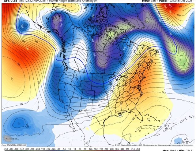
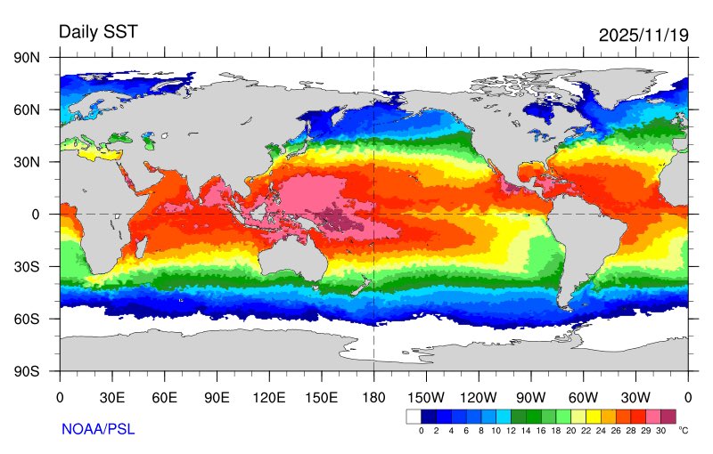
Eric Webb @webberweather The current global SSTa pattern is very favorable for the -EPO/+TNH pattern w/ the warmest water on the entire planet ~160E in the South Eq Pacific. The MJO is obviously giving it a huge boost here too. Eric Webb @webberweather · 16m I definitely underestimated how quickly this winter would dip into the ‘ol well of -EPO/+TNH we’ve seen so frequently the last 10-15 years. This pattern is only going to get stronger later in winter when the polar vortex intensifies& the warm pool starts zonally advecting east.
-

November 2025 general discussions and probable topic derailings ...
SJonesWX replied to Typhoon Tip's topic in New England
0.0” here, not even a drop. Last fall cleanup completed this morning


