All Activity
- Past hour
-

Central PA Spring 2026 Discussion/Obs Thread
Jns2183 replied to Voyager's topic in Upstate New York/Pennsylvania
Yup had entrainment and a cold pool while us in the valley got double teamed with cold pool and outflow flowing in from north and south. Future reminder is that if storms fire on both sides of the elevator train north and south of me to not expect much it's physics usually wins in the situations with cold air draining in undercutting all of our instability Sent from my SM-S731U using Tapatalk -
Oh I get it... sorry Ray. ha
-

E PA/NJ/DE Spring 2026 Obs/Discussion
JTA66 replied to PhiEaglesfan712's topic in Philadelphia Region
What a glorious morning! Windows open with fresh air pouring in, not a ray of scorching sunshine to be found, rain coming down and beautiful temps...55F/DP 50F -
.34 so far with this batch coming through
-
Literally every day at your place will be 80 or above. It’s a warm dry airmass . This is like last week when we said 90’s this week and posters said no 90’s
-
Well, in my limited knowledge of meteorology…I think he means let’s have that high set up there , to add a good fight back to the surging moisture that the STJ may provide…and perhaps give us an enhanced risk of wintry weather. But I certainly could be wrong…
-
Drought worsened significantly in NC with virtually zero rain over last two weeks. Hopefully this is the peak
-
I think Ray may actually be one of the aliens the current zeitgeist thinks walks amongst us? It would explain how that list of verbiage actually constructs a workable communication because it probably is lucid comprehension in the mind of a Zargon - As a software engineer with decades of experience no less, I cannot seem to decode this: "Let's station that there to add resistance"
-
uhmm ... can you help me parse out this sentence ^ ?
-
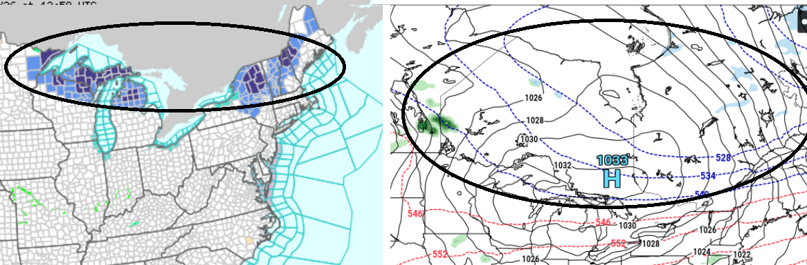
North Carolina | Drought.gov. Exceptional in NW NC or 3.5% of NC
-
Let's station that there to add resistance to the STJ next winter...that would be neat-
-
I'll tell ya tho ...whatever happens this weekend .. next week aside, until this crap stops, it ain't summer! not even close. I don't care wtf it was like the last 3 days ... not a summer hemisphere.

-
-
Huh….? You are wrong. 2025-2026 winter was pretty dam good, two blizzards(one with single digit temps of 5-6 degrees), a 12/26 evening 9”er also with frigid temps. and very good cold all season..with good pack….that was pretty dam good imo.
-
I think that is on the right track. The focus for the heavy rain today will definitely be well to the northwest, and while it will eventually sink southeast into the metro areas later this afternoon, it will be weakening as it does.
-
Figures Tuesday will be nice for back to work. What a pile of garbage this weekend.
-
lol…maybe Wednesday…other then that 70’s, which is fine by me.
-
There are a few cases over the years whence something of sufficient magnitude penetrates the late spring/summer climate gauntlet enough to afflict a truly, perniciously shitty scenario. Just think back to the infamous July 4th weekend, 2020. 40s ( and I don't mean 'Kevin 40s'; real 40s), NE wind, rain. In fact, the May 1977 freak snow storm also fits into this sort of phenomenon - tho the snowing aspect might send some to feeling that's gotta be something extra double special and different but no ... Barring those few/rarer exceptions, after about ... ~ May 10th, shit outlooks tend to flop on the side of better when the days actually happen. I think this weekend may end up more in this ilk of inconvenience. We'll see. But I suspect Saturday is dry with some dim sun visible N of the Pike through early afternoon, then it gets more lorded over but still dry through evening. Sunday'll suck most likely... but given to the blocking that's setting up down stream, I could also see that correct a little drier as the day nears. Not sure what to make of Monday... Guidances are trying to create cold season meso lows near the Cape like it's December and trying to preserve a 31F dammed up icing scenario near FIT. No shame in the guidance about what time of year it is. Or, it's just an homage to the unusual blocking going on. That's odd btw. It's like there's a power house -NAO ridge pinning a Maritime trough in place... without having the ridge. The block appears to be non linear... like you just can't see it them, but they are there; forces are just spontaneously folding up a trough over the Maritime. It's stopping us from bouncing back very warm next week, too. Not sure how much of that is real.
-
At this rate, probably. Already getting crispy here. This weekend looks like shit, but also, very little actual rain. Double whammy of suck
-

2026-2027 Strong/Super El Nino
GaWx replied to Stormchaserchuck1's topic in Weather Forecasting and Discussion
Thanks. Actually at the current point in time, I have 2026 to be most similar to 2015: check this out 13MAY2015 1.3 0.7 0.6 0.7 20MAY2015 1.3 0.5 0.5 0.8 13MAY2026 1.3 0.6 0.5 0.6 -
We sun

-
Next week is 80’s all week
-
Nice soaker this morning. Temp down to 56.
-

2026-2027 Strong/Super El Nino
snowman19 replied to Stormchaserchuck1's topic in Weather Forecasting and Discussion
-
Getting a soaking rain here the past couple of hours. Down to 57 degrees.