All Activity
- Past hour
-
Yeah, Elliott has been saying that today was going to be relatively dry followed by the best opportunity all week for rain overnight tonight into tomorrow.
-
This was supposed to be a very active season. Another blown long range outlook.
-
Finished with .33" of rain at home. Hoping everyone gets wet tomorrow.
-

Invest 94L—30% 2 day and 80% seven day odds of development
MJO812 replied to WxWatcher007's topic in Tropical Headquarters
Agree One will most likely be affecting the other one. -
This is the most useless tropical season that I can recall....yet to even acknowledge the season the on blog. Nothing to see here, either.....except the same 2 or 3 "doing it"....
-
.18" at home. In North Conway NH for the week. Beautiful area. Hit Mt Washington on Monday before the clouds rolled in. Breathtaking views.
-

September 2025 OBS-Discussion centered NYC subforum
psv88 replied to wdrag's topic in New York City Metro
0.05 -
 Agreed! The balancing act between systems will be fascinating to watch
 -

2025-2026 ENSO
donsutherland1 replied to 40/70 Benchmark's topic in Weather Forecasting and Discussion
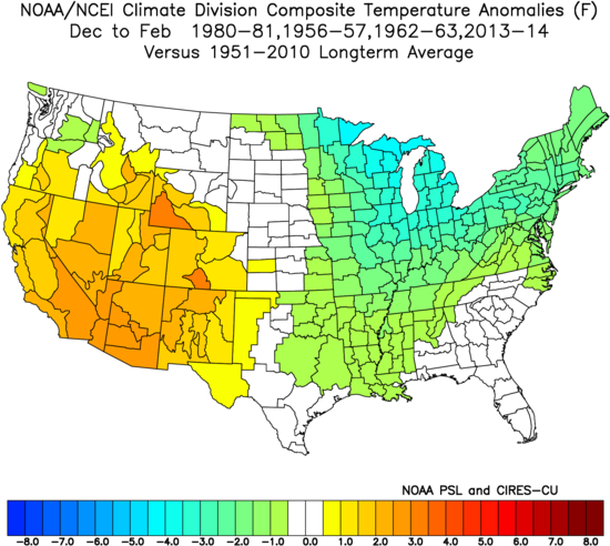
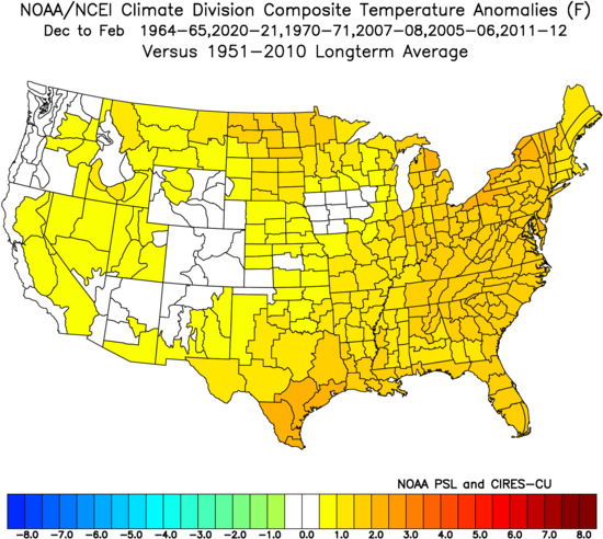
With respect to the EPO, the swing from the minimum value during the first half of September to the maximum value (so far) for the second half of September is the fourth largest on record. All of the prior 10 biggest such cases occurred during the evolution toward either La Niña or Neutral-Cool ENSO winters. The composite temperature anomalies for the Neutral-Cool ENSO Winters: The composite temperature anomalies for the Neutral-Cool ENSO Winters: However, warmth is not a slam dunk for the Northeast/Great Lakes. Winters 1964-65 and 1970-71 were cold in the Northeast, Great Lakes, and Northern Plains. Winters 2007-08 and 2020-2021 were cold in the Central Plains. Finally, the sample size is limited to 10 extreme EPO cases.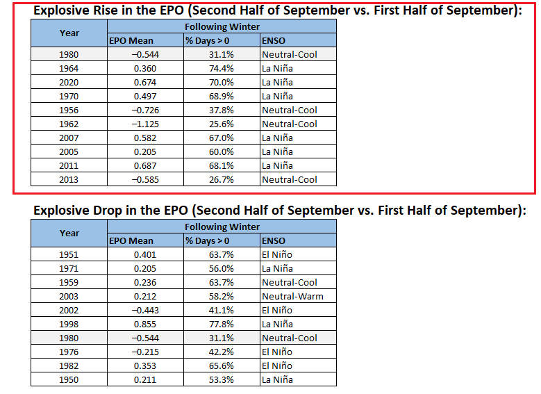
-
Let’s get RI’s rain total to match Dendy’s total since June.
-
Well, I guess this is good weather to get work done. Interesting to see DeepMind mentioned in the LWX disco. Neural nets and GenAI are legit…those computing resources, though.
-
 It does seem like a landfall is becoming somewhat unlikely for 94L because it gets pulled back out to sea by 93L. Meanwhile 93L is too far out to have a decent chance of being pulled into the coast by 94L. The most likely landfall scenario is a combination of 93L being weaker than expected and more spacing between the systems allowing 94L to be pulled into the coast by the ULL
 -
1-2” from wrn RI to New Bedford.
-

-
-
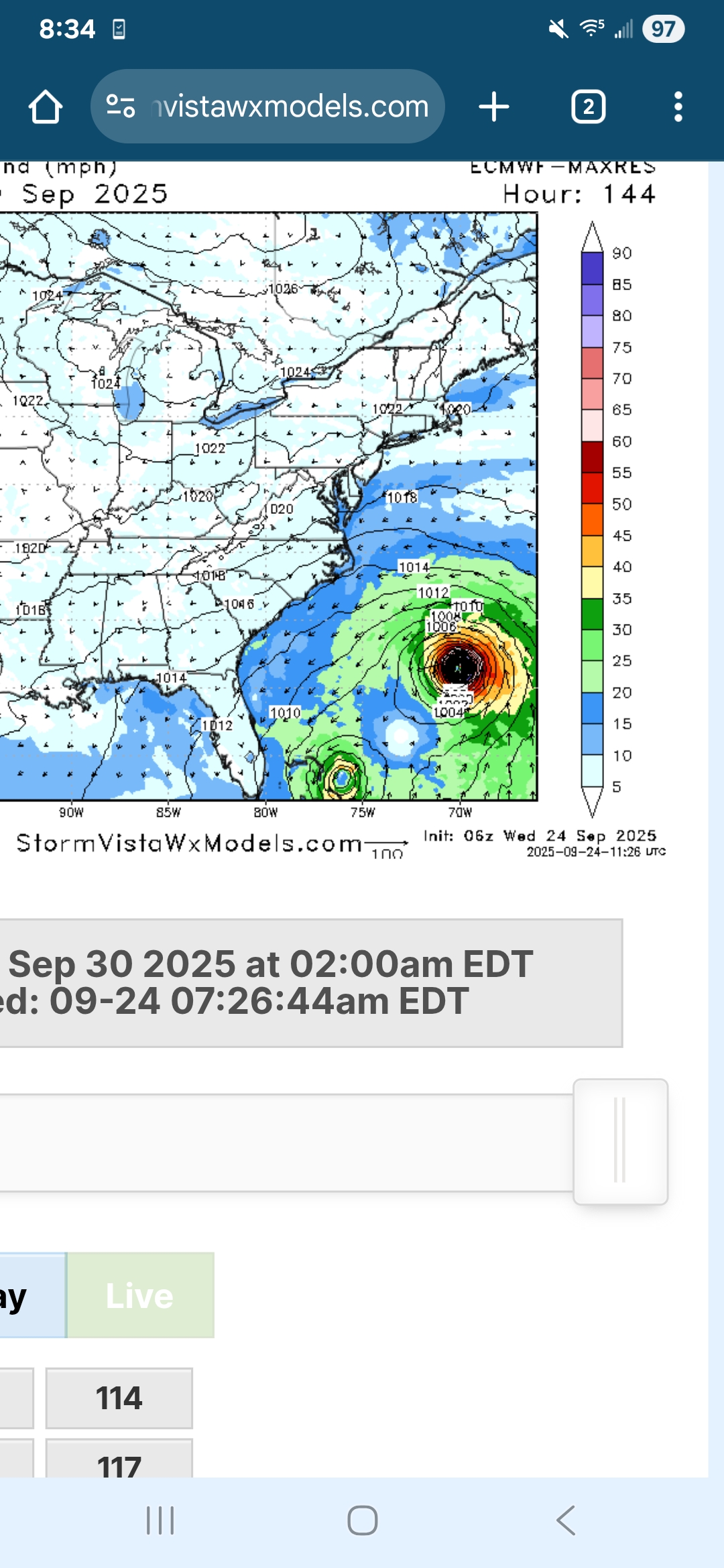
Recon might start sampling the environment today per NHC. This is a really complicated setup with the two systems so close. 00z EPS
-
It's been moving around
-
6z EURO is completely different from 0z.. hr 144 one is left in the Bahamas and the other is heading NW.. but would probably be eventually pushed out?
-
Man RI and the South coast is getting slammed right now..if we could just keep that heading north a little ways and we’d all get a good soaking!
-
 Eastern Caribbean Sea (AL94): A tropical wave over the northeastern Caribbean Sea is producing disorganized showers and thunderstorms. This wave is expected to move west-northwestward at 15 to 20 mph, spreading heavy rainfall and gusty winds into Puerto Rico and the Virgin Islands today, and across the Dominican Republic beginning tonight. The system is then expected to slow down and turn northwestward when it reaches the southwestern Atlantic late this week. Environmental conditions are forecast to be more conducive for development in a few days, and a tropical depression is likely to form when the disturbance is in the vicinity of the Bahamas. Interests in the Virgin Islands, Puerto Rico, the Dominican Republic, the Turks and Caicos Islands, and the Bahamas should monitor the progress of this system. An Air Force Hurricane Hunter Aircraft is scheduled to perform a system survey this afternoon to gather data from the surrounding environment, if necessary. * Formation chance through 48 hours...low...30 percent. * Formation chance through 7 days...high...80 percent.
 -
Good chance this becomes a TD later today or tonight. Despite westerly shear the organizational trend continues.
-
Euro has to be testing the physical limitations for how close 2 tropical cyclones can be to one another.
- Today
-
It was always CT.
-
Picked up 1.02" of rain from yesterdays system. Millersville well over 2" of rain.
-

September 2025 OBS-Discussion centered NYC subforum
wdrag replied to wdrag's topic in New York City Metro
Continuing review for a possible thread 6PM today for 22z/24-12z/26.Pprior posts by Bluewave have it right. 1-3 iso 5 possible. Getting complex. The closed low OH Valley will happen and looking like we get something addition from it 18z Sat-18z Sun. Thereafter, uncertainty greater but as noted previously, tropics get involved with the east coast trough-W Atcl ridge. At a minimum, I would not be fishing in the coastal waters next Tue-Wed. Even if the tropics peel east-shunted s, the large cool high settling into New England sets up the potential for an early season modest gale on the CW s of LI and e of NJ, assisted by the larger BL temp lapse rate. Offline most of the day. 0.24 here in this part of nw NJ last evening.