All Activity
- Past hour
-
Man I'm done tracking sliders. They don't make it here and I'm beyond over it, smh
-
Don’t know why, but I’m feeling really invested in this one lol. We don’t get many chances for cold powder daytime snows, let alone in December. I want something Friday!
-
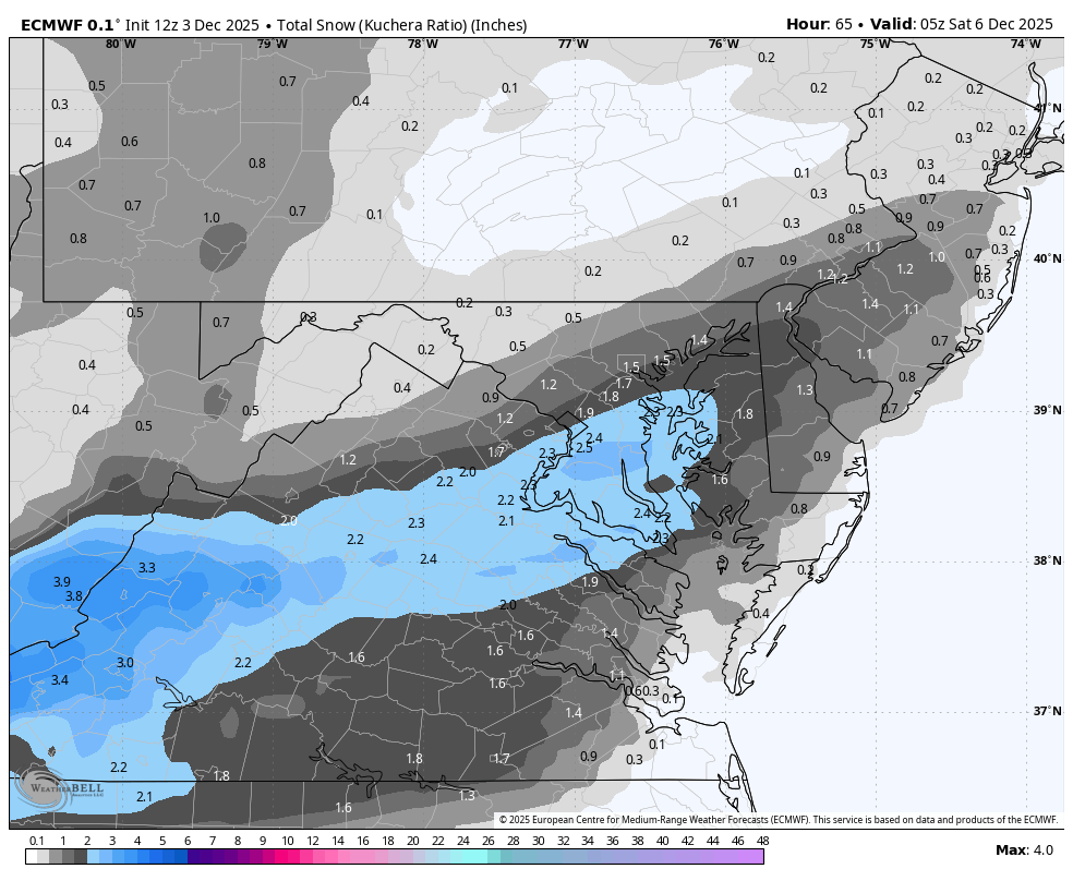
Not really...See that all too familiar wall at Baltimore City? That wasn't there at 6z, and is in keeping with what all sliders have done since 2018.
-
Yes, but unfortunately that is around .1 of actual qdf! The general synoptic pattern is locked in so now we just get to see how exactly it plays out.
-
Had .75 last night which was a nice surprise. Lots of blowing too made it wintry. Id imagine the northern mountains and foothills will do well with the upcoming storm. Rooting for you guys further south and in Asheville.
-

December 2025 regional war/obs/disco thread
40/70 Benchmark replied to Torch Tiger's topic in New England
I'm so sick of the social mediaologists advertising "wild times"....GTF outta here with that. If I can't see "wild" out my window, and I have to look at the thermometer, then that isn't wild. Wait until a major storm is consistently modeled. -
Euro clown.
.thumb.png.882c5248b239f50d8c18a1374613ca8d.png)
-
For me that is incorrect, I went from 1.5 inches to .2. Or I went from a dusting to a flurry. I hope someone in M.A. gets 2 inches.
-

December 2025 regional war/obs/disco thread
Snowcrazed71 replied to Torch Tiger's topic in New England
I may not always agree or like what you say, but I nearly spit my lunch out after reading what you wrote. I think I'm starting to appreciate and understand your sick sense of humor. Lol -
Mondays event has a much higher ceiling than Friday. If you get more of a negative tilt to the trough you can really crank a coastal. At this point I’d say less likely given the progressive nature of the pattern and it being NS dominant but with a -NAO and well timed Arctic high this is one that could develop quickly on modeling. Definitely interesting to watch tho a lot to work out with 2 systems this weekend. Fridays event is pretty straight forward. Kind of an overrunning event with transient HP. Earlier arrival and heavier rates equals better chance of seeing flakes. I’d say the ceiling is a stripe of 1-3” likely in southern Virginia. Without much upper level support and a strung out system, plus marginal cold with a transient HP, I think you’re on hopium if you think it would be more than that. Can say if you’re in western and the northern half of piedmont areas in NC and the southern half of VA you definitely stand the chance of at least minimal accumulation. Would be fun given the early November system to see most of the state with at least 1 accumulating snowfall before Christmas even if just marginal
-
I don't believe one exists unless someone has done an extensive reanalysis effort? After all it was only just discovered in the early 70's. Would love to see it though if someone did.
-
Just preconditioning the next drop, barring steady AMOC weakening. I expect noise from the usual suspects to get louder right up until the point that they (once again) go silent. Difference this go-around is that the cave-out is likely to come from the Atlantic front this time around since most of the MYI losses that could happen on the Pacific front already have. The vicious feedback of shoaling AW layer --> sensible+latent heat flux to trop --> stronger Ural/Scand. ridging --> PV disruption --> strengthening meridional transport --> shoaling AW layer has a lot further to go if CMIP6 is onto something. And winter warming is necessary to precondition the next drop anyways.
-
Euro is about the same. A little better for Triangle north
-
12z Euro will make less friends than 6z or 0z but it's fine
-
We are splitting hairs here man. 12z 6z
-

The Return of the 12/5 Snowstorm
NorthArlington101 replied to SnowenOutThere's topic in Mid Atlantic
EURO a decent tick further south (or at least just less precip on the north end) with the best of it's goods but I'll still buy what it's selling. -
Thread it!
-
WB 12Z EURO ticked SE...

-
I think the 12z Euro should be pretty similar to its 6z run
-

Mountain West Discussion
mayjawintastawm replied to mayjawintastawm's topic in Central/Western States
3.5" here at 10 AM. This has been a very typical light upslope storm, and also typical in that the foothills north and west of town got the most (so far), as opposed to south. Winds were a little more east than north. Really well predicted! -

December 2025 regional war/obs/disco thread
Typhoon Tip replied to Torch Tiger's topic in New England
Well ...if perhaps only conciliatory, the D10/11 12z GFS offering is definitely intriguing. This 500mb cinema depicts a powerful S/W morphing into negative orientation, going under long island. The surface is odd...with a lot of primary near Buffalo, despite this ominous mechanical appeal above. At this time, however ..there is a hint if not outright zygote low developing near CC. This is odd/idiosyncratic failure to generate a robust development/commitment to a coastal, earlier...and I suspect it is related to the lack of +PP N of the region as this thing above is evolving. We seem to be a lull in b-c gradient ...but, D7 ...that could change. It would not take much, should this amplitude above turn into a confident trend ( so a bit of a caveat emptor ...), to reacquaint the 10th/11th as a period to watch. I realize it is only 7/8 days out but... as we've been warning, this fast flow type can "hide" events and have them rear up in shorter notice.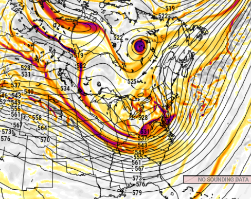
-
3.2 is correct.
-
What is this? Hunger games fighting over the track of a 2 inch storm?!
-

December 2025 regional war/obs/disco thread
WinterWolf replied to Torch Tiger's topic in New England
My call-No grinch this year…it’s a different year. -
Yep on edge of frontal passage. Doubt it amounts to much but Im loving the mood flakes on mood flakes vibe


.png.17418d071ff22893fa1ff19e1927f3f4.png)