All Activity
- Past hour
-

The return of the elusive Nor'easter. Drought buster or bust?
Maestrobjwa replied to dailylurker's topic in Mid Atlantic
Well, at least if this does turn into a bust makes sense given the enso state. Things coming together too late is a classic nina thing! I'd rather have at least have a reason for the fail than just "bad luck", lol -

Spooky Season (October Disco Thread)
kdxken replied to Prismshine Productions's topic in New England
That's not what the yellow jackets say. They're all over the place today. -

-
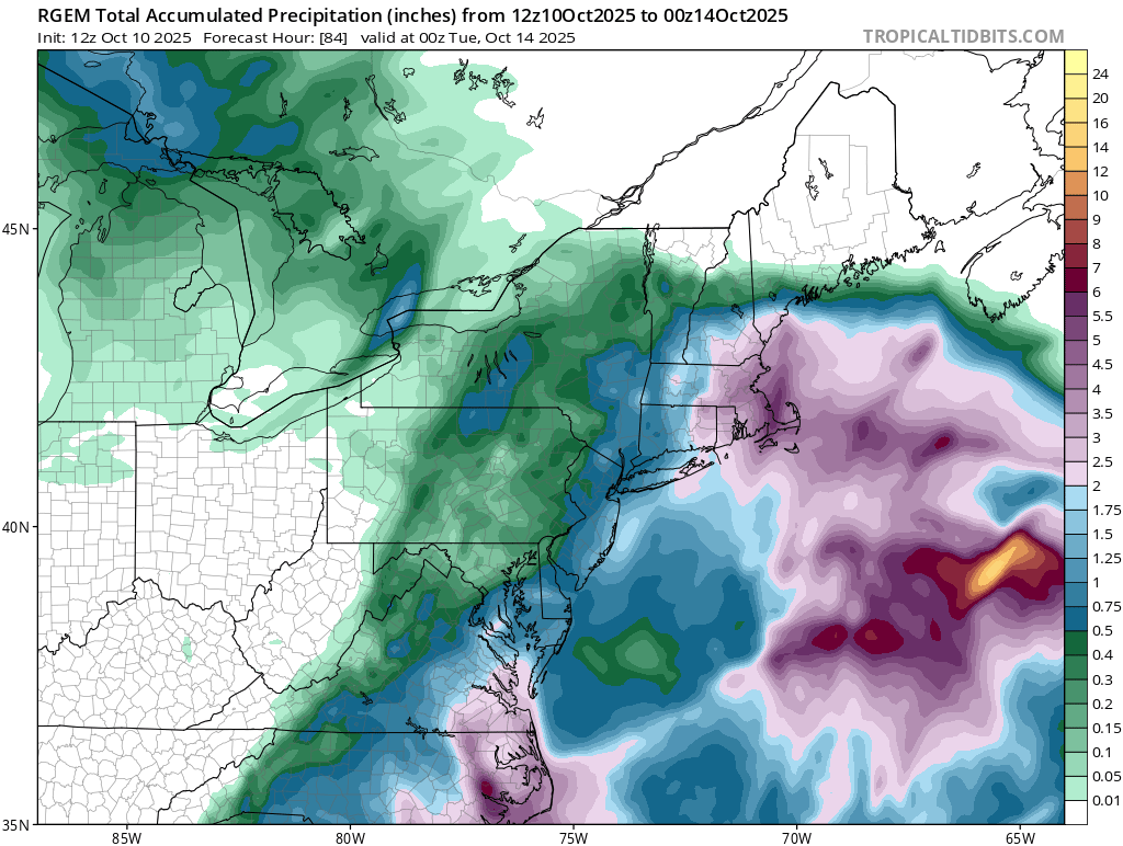
RGEM and NAM are quite different.
-
I doubt we will see freezing rain.
-
it's just rain and a little wind. i highly doubt it would impact any driving, unless they are like 100 years old and shouldn't be driving anyway.
-
RGEM is 5-6".
-
 I was referring to the area of convection over SE New England. Those often rob the dynamics of the low. RGEM therefore destroys the Boston area.
-
One important difference is the AAM. Last year at this time it was in full on El Nino (positive). This year, it is and has been very strongly negative
-

"Potentially" powerful Nor'easter Sun-Mon 10/12-13/25 with needed rain-especially south of I84, and fairly high impact sct coastal gusts 50+ MPH and possibly moderate or greater coastal flooding at the midday Sun and Monday high tide cycles.
Stormlover74 replied to wdrag's topic in New York City Metro
The low isn't so far east on the rgem. Its just weak without a lot of heavy rain outside of LI and the immediate coast -

The return of the elusive Nor'easter. Drought buster or bust?
WEATHER53 replied to dailylurker's topic in Mid Atlantic
Models won’t get this right. A lot of combined energies exploding right over the mid Atlantic region . -
I hope we getting nothing.
-
We'll have to watch over the next day or so if the models chasing convection to the NE of the main low are real or convective feedback. Models sometimes do it at this range only to consolidate it as we get close, and sometimes it makes that area the main low and robs all dynamics of the main storm. All options still on the table, but I'm leaning towards a milder event.
-
The return of the elusive Nor'easter. Drought buster or bust?
Maestrobjwa replied to dailylurker's topic in Mid Atlantic
2016, right? -
Why not
-
Jesus, I was just looking back at my winter wx records. No wonder why winter is my least favorite season now. 2014-15: 27.3" (DC) 2015-16: 28.5" (DC) 2016-17: 5.6" (DC) 2017-18: 12.5" (DC) 2018-19: 30.3" (CT) 2019-20: 16.5" (CT) 2020-21: 44.5" (CT) 2021-22: 28.8" (CT) 2022-23: 13.7" (CT) 2023-24: 24.7" (CT) 2024-25: 19.8" (CT) Unmitigated disaster. For the love of God let's turn this around.
-

Spooky Season (October Disco Thread)
Typhoon Tip replied to Prismshine Productions's topic in New England
impressive to see a 27 F recovery by 11am ... That's a lot. Might be the most explosive diurnal turn around (rate of change) we've seen in some time. We could make 60, which put this in contention for biggest spread, too. -
"Potentially" powerful Nor'easter Sun-Mon 10/12-13/25 with needed rain-especially south of I84, and fairly high impact sct coastal gusts 50+ MPH and possibly moderate or greater coastal flooding at the midday Sun and Monday high tide cycles.
Stormlover74 replied to wdrag's topic in New York City Metro
Just light rain on the rgem -
 Just imagine if this were dead of winter with temps in the 20's! My god it would be incredible.
 -
 12z NAM as others have said previously this page: Heavy qpf is slated for our NYC subforum, especially e PA/NJ/LI..wind driven pelting rain. 12z NAM is more of a hugger so that can change but what I noted in that cycle... 7H FGEN shift northward well up into central New England Monday. They are going to get some decent mid level rain. I'm trying to attach the 850MB FGEN LOOP. Note a couple things: 850 FGEN trying to get sct showers going se NYS/NJ Saturday and then the big dump from 66hours on to 84 hrs... nearly stationary decent 850 MB FGEN with 70KT 850 MB easterly inflow band... no wonder spot nearly 8" near Toms River. Modeling will change but if indeed the 850 and 7H low are passing across the Delmarva...we get hit hard. Just want to make sure it doesn't fritter eastward. vertically stacked lows Delmarva to s NJ/s of LI are our sweet spot with heaviest qpf often spilling further nw than modeled. Now lets see what future cycles will offer as well as other modeling. https://www.tropicaltidbits.com/analysis/models/?model=namconus®ion=neus&pkg=temp_adv_fgen_850&runtime=2025101012&fh=84
- 116 replies
-
- 1
-

-
- heavy rain
- damaging wind
- (and 2 more)
-
Interesting. There have been large flocks hanging at the lake by my house for a few weeks now.
-
Spooky Season (October Disco Thread)
Typhoon Tip replied to Prismshine Productions's topic in New England
No it isn't; complete conspiracy -

The return of the elusive Nor'easter. Drought buster or bust?
hstorm replied to dailylurker's topic in Mid Atlantic
"Winter is over" bridge jumping on October 10 has to be a new forum record. Well done! -

Spooky Season (October Disco Thread)
ROOSTA replied to Prismshine Productions's topic in New England
I really miss the change of seasons. My nightmare will soon be over. I'm only going to get about 1/2 the going market price. SCREWED! A plan I've started to seriously consider is leaving everything possession wise, buying a RV and travel till end of days. -
the overnight low was 36. the house is a still a little chilly.