All Activity
- Past hour
-
I knew playing let it snow 50 times yesterday would do the trick.
-
I agree with you. They are messy and can give us hellacious ice storms, but they usually roll in good and juiced.
-

Minor snowfall sunday 12/14/25 1-4” possible
Jersey_Snowhole replied to WeatherGeek2025's topic in New York City Metro
You going to quote the follow up to that when I said NYC is likely to get more -
That 3.5" marker over central MoCo is just about on top of where I live (Gaithersburg, near Laytonsville), I'll take that.
-
Rob = The Snow Natzi bahaha
-

Central PA Winter 25/26 Discussion and Obs
canderson replied to MAG5035's topic in Upstate New York/Pennsylvania
Gonna be leaving Philly around 8 pm. We'lll se how that goes. -
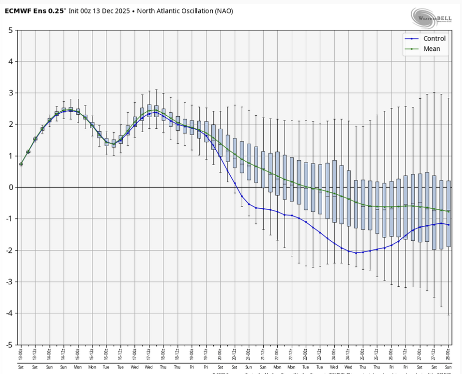
Maybe the models are showing this due to a new -NAO signal for CAD events, but I'm not sure.
-
I think we are good for a minimum of 2.5” honestly. Even the warmer solutions at the start come in super heavy and drop 2”+ in 3 hours. Getting excited.
-
Watching for an expansion of wwa west to cover Loudoun and Frederick counties
-

December 14th - Snow showers or Plowable snow?
Damage In Tolland replied to Sey-Mour Snow's topic in New England
Should see advisories up to MA/CT border with afternoon package . Maybe even southern tiers of 4 MA counties -
Great post from @wxmvpete
-
Sold
-

Minor snowfall sunday 12/14/25 1-4” possible
jbenedet replied to WeatherGeek2025's topic in New York City Metro
It’s a narrow band of frontogenesis. Sinking/subsidence just to the north. Another way to put it is the stronger the band, the worse the subsidence in areas just north of it. Have and have nots right across the sound. Not an exact forecast here but from a conceptual standpoint it’s a case where commack LI could see 6” and north haven CT, 1.5”. The modeling likely underdone on the gradient (delta). -

December 14th - Snow showers or Plowable snow?
CoastalWx replied to Sey-Mour Snow's topic in New England
Some signs it lingers near the coast too. @SouthCoastMAnight be a good spot for this. East of him may initially have boundary layer issues, but winds go light NW which is good trajectory for him. -
No snow for you! I kid, I kid. Here's to a great game!
-

December 14th - Snow showers or Plowable snow?
ORH_wxman replied to Sey-Mour Snow's topic in New England
Slowing it down is prob actually good because it gives it time to buckle a bit…we don’t want it blowing up completely after our longitude. If it can be allowed to buckle a bit and blow up further west, then the warning-level goods could scrape the south coast and Cape -

Pittsburgh/Western PA WINTER ‘25/‘26
Rd9108 replied to Burghblizz's topic in Upstate New York/Pennsylvania
Hopefully we maximize the potential. With the earlier arrival of precip are we expected to get the heavier rates earlier? -
-

December 14th - Snow showers or Plowable snow?
WinterWolf replied to Sey-Mour Snow's topic in New England
Yes, from what we had the last few years…an inch more is “Much” now. -
December 14th - Snow showers or Plowable snow?
ORH_wxman replied to Sey-Mour Snow's topic in New England
Hrrr really hammers the Cape and maybe parts of adjacent SE MA with legit fronto banding. -
Minor snowfall sunday 12/14/25 1-4” possible
jbenedet replied to WeatherGeek2025's topic in New York City Metro
I would NOT be using this rationale to go lower. They will lose on that. Looks good for 99% snow. -

December 14th - Snow showers or Plowable snow?
Sey-Mour Snow replied to Sey-Mour Snow's topic in New England
NAM just kinda looked delayed, I thought it lost it at first lol -

Minor snowfall sunday 12/14/25 1-4” possible
North and West replied to WeatherGeek2025's topic in New York City Metro
does he make these with Microsoft Paint . -
I mean it should based on all the models coming in and even the 6z euro
-

Central PA Winter 25/26 Discussion and Obs
AccuChris replied to MAG5035's topic in Upstate New York/Pennsylvania
12z 3km NAM kuchera snow .


