All Activity
- Past hour
-
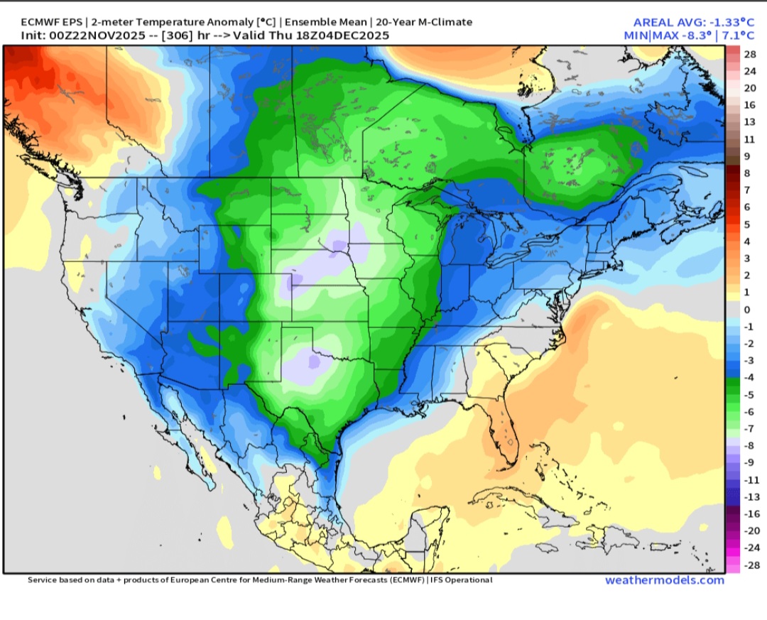
Looks like the main storm track will stay west of us at least through the Ohio Valley up into Canada through December 5th with quick shots of colder air - progressive pattern with no established cold air YET....
-
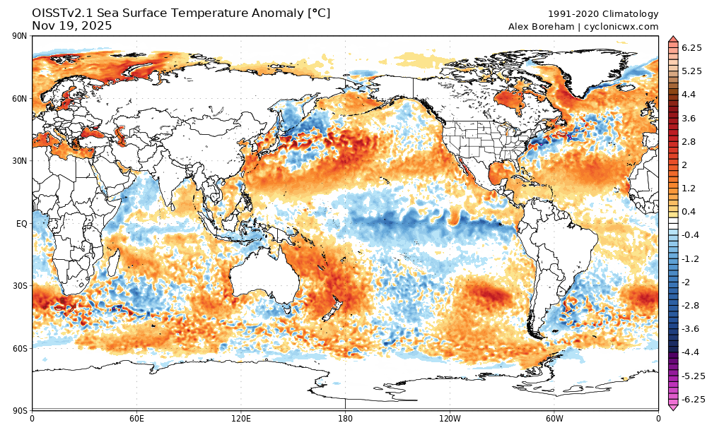
The question is what period you're discussing. There are conflicting signs the way I see it. Even conflicts with the models' own MJO forecasts and 5H forecasts. In the end, all that be done is to look at modeling and hug whichever one suites one's opinion/gut/biases since everything remains on the table once out 7+ days. But we can't deny the medium and long range forecasts this year of warm, like last year, have not been great. So that along with a weak Niña on its way out the door by year end with noticeable western Pacific cooling, I think the urge to assume warmer LR forecasts are going to verify is risky for now. If they do verify, that will change things in my weenie mind.
.png.4f1b6f294b3cd73267726f5651715f84.png)
-
Yup. We've really devolved into a winter climate more akin to Georgia or South Carolina.
-

2025-2026 ENSO
Stormchaserchuck1 replied to 40/70 Benchmark's topic in Weather Forecasting and Discussion
What is with these weird hours? 354hr? 306hr? We'll probably get a below average period after Thanksgiving into the first week of Dec as the EPO will be negative.. probably unlikely we see snow though. Then the pattern retrogrades and changes pretty quickly. -
They always tell employees Thanksgiving weekend, obviously with the caveat of conditions permitting. We all know that's not realistic. It's generally mid December but I'm not seeing how that will be possible this year. Or if they can manage to get the guns fired up, it'll be very limited operations. As anyone around here knows, you qualify every forecast statement with the asterisk "I could be wrong". I hope I get frostbite from a stinging blizzard over and over...but the overall setup we are all staring at is one of a warm and dry winter.
-

November 2025 general discussions and probable topic derailings ...
WinterWolf replied to Typhoon Tip's topic in New England
So the AI had the rain getting up in here, and the other non AI guidance did not? -
Winter cancel? 0z EPS DEC 4

-

November 2025 general discussions and probable topic derailings ...
CoastalWx replied to Typhoon Tip's topic in New England
I wish i looked harder. Maybe there were red flags. AI was one of them. -
November 2025 general discussions and probable topic derailings ...
WinterWolf replied to Typhoon Tip's topic in New England
Honestly, What is wrong with this guidance? It’s so much worse than it was, and I don’t even think that’s debatable anymore. WTF? -

Occasional Thoughts on Climate Change
TheClimateChanger replied to donsutherland1's topic in Climate Change
-
 I was just going off the last time I looked at anything: Thursday. Then was surprised to feel rain on way to gym this morning
 -
November 2025 general discussions and probable topic derailings ...
CoastalWx replied to Typhoon Tip's topic in New England
That was also an 18hr forecast. Kill the horse, send it to the glue factory. -

November 2025 general discussions and probable topic derailings ...
jsw replied to Typhoon Tip's topic in New England
Weather related: a weaker polar vortex = colder air in New England, if I read this correctly. https://www.wbur.org/news/2025/11/21/polar-vortex-what-to-know-new-england-boston-december?utm_source=npr.org&utm_medium=referral&utm_campaign=local_headlines&utm_content=homepage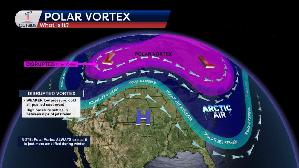
-
Occasional Thoughts on Climate Change
TheClimateChanger replied to donsutherland1's topic in Climate Change
-
48 hr forecast from the Euro. Whoops.
-
Any estimates on when they plan to open?
-
2025-2026 ENSO
Stormchaserchuck1 replied to 40/70 Benchmark's topic in Weather Forecasting and Discussion
You're not going to get a below average temp pattern with that upper latitude and Pacific H5. That's a +2 +nao and developing -pna.. it's going to flux the SE ridge after unless the models are wrong about those 2 patterns. CFS MJO? I'd look more at the plots bluewave posted above. -
Obviously way too early to declare victory, but if this SPV progression verifies, at least the December ideas in your winter forecast are going to be very good. Paul Roundy is also in agreement with you that the PNA goes negative/RNA once we start getting towards mid-December based on the expected progression of low frequency tropical convective forcing….. ^ “This morning's zonal GPH anomaly plot + GFS forecast, showing the strato PV disturbance peaking during the week/10 days, and reaching down to about 50 hPa. There appears to be some propagation to lower levels later on, but the models contrast sharply in this regard, with ECM showing a re-strengthening of the PV in the same timeframe. It aligns with the overall trend observed, with the current PV displacement resulting from a stronger strato anticyclone over Alaska/Canada, and the vortex core shifting over Siberia. After that, ENS members show a possible re-centering over the Arctic, with the anticyclonic area losing intensity and effects over the PV. We'll need to monitor what happens in the next two weeks or so.”
-
If you put this EPS in motion prior to the 360hr link below, the SER is getting squashed. Also, AO region looks good. Plus, beyond this period, the Eps extended shows movement into 8. Still not high confidence on the MJO, but Cfs2, which is an extension of the Gefs, has the MJO in 8 too. So there's evidence of positive steps in December, which is better than the opposite. https://www.tropicaltidbits.com/analysis/models/?model=eps®ion=nhem&pkg=z500a&runtime=2025112200&fh=360
.png.1873ebb2c4fff5b9d53a9c9cf4711640.png)
-
 Yesterdays 6z guidance didn’t even have rain here.
 -

November 2025 general discussions and probable topic derailings ...
amarshall replied to Typhoon Tip's topic in New England
Fully nude ready to do leaves all day. Looking forward to a few crisp Pilsners and loud power tools all afternoon. . -

Central PA Fall Discussions and Obs
Mount Joy Snowman replied to ChescoWx's topic in Upstate New York/Pennsylvania
Low of 46 with .26” of rain. -
Unfortunately I think you're correct. Today is orientation day for the seasonal workers at Wisp and I'm getting the pbp of a seriously dour ski season outlook. They are warning folks they may not be able to provide 40 hours per week due to their forecast of a subpar season, much like 22-23. East of the Mississippi and south of I-90, there isn't even any fantasy snow to look at. I'm well aware of the calendar date today but I'm also well aware flashing red lights rarely become green arrows.
-
November 2025 general discussions and probable topic derailings ...
CoastalWx replied to Typhoon Tip's topic in New England
I remember seeing AI much further north and was thinking it was wrong. Let’s replace us all with machines baby. -
Found @Jis burner account


.thumb.JPG.418e8a9a2902ae687ec35ff4bc0e038e.JPG)