All Activity
- Past hour
-
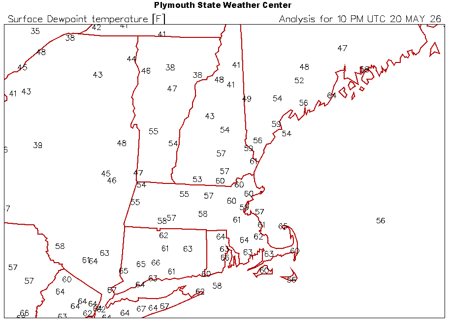
0.09" for the beginning of our drought buster. 1.25" so far for the month. Turned into a nice afternoon/evening albeit a bit humid (DPs ~65).
-
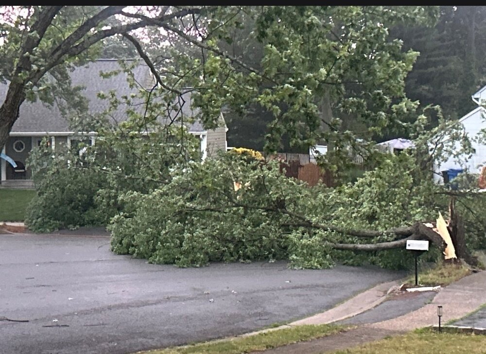
Another tree on his circle. Snapped
-
. 27 so far with some light rain falling. Hopefully more to come.
-

2026-2027 Strong/Super El Nino
MJO812 replied to Stormchaserchuck1's topic in Weather Forecasting and Discussion
Strong El Nino with alot of blocking would be great. -
Records: Highs: EWR: 99 (1996) NYC: 96 (1996) LGA: 97 (1996) JFK: 95 (1996) Lows: EWR: 41 (2002) NYC: 43 (2002) LGA: 44 (2002) JFK: 42 (2002) Historical: 1892: Snow and high winds pelted western New England, leaving 10 inches on the ground at Strafford, VT. 1894 - A record late snow of two to eight inches whitened parts of central and eastern Kentucky. Lexington KY received six inches of snow. (The Weather Channel) 1916 - A tornado struck the town of Codell, KS. A tornado struck the town on the same day the following year (1917), and a third tornado hit Cordell on May 20th in 1918. (The Weather Channel) 1949: Eight or more tornadoes were involved along an 85 mile long track across the counties of Gray, Ford, Hodgeman and Pawnee. Newspapers in the area used headlines such as Tornado army attacks Kansas to describe the record breaking number of tornadoes, at least 40 that hit the central and western part of the state. No people were killed, but hundreds of animals perished. Four funnels were seen moving northeast about 6 miles northwest of Dodge City. A tornado moved northeast from 7 miles southwest of Coldwater, KS and just missing that town, and ending at Wilmore. The "huge rotating column" sent the entire town of Coldwater running to storm cellars. Most of the $200,000 damage was at Wilmore, as the entire town was torn apart. This is only one of two days in recorded U.S. history up to this time when 100 or more tornadoes occurred. The other was April 3, 1974. 1956: Near Bethel, Delaware, lightning hit a home; a family of seven was literally blown out of their beds (all survived). Sides of the house “bulged out” and the front door was blown out. Plaster was knocked from the ceiling/walls. It looked like a bomb had been thrown into the house. (Ref. Weather Guide Calendar with Phenomenal Weather Events 2012 Accord Pub. 2011, USA) 1957 - A tornado touched down to the southwest of Kansas City and traveled a distance of seventy-one miles cutting a swath of near total destruction through the southeastern suburbs of Ruskin Heights and Hickman Mills. The tornado claimed the lives of forty-five persons, and left hundreds homeless. It was the worst weather disaster of record for Kansas City. About all that remained of one house was a small table and a fish bowl atop, with the fish still swimming about inside the bowl, rather unconcerned. (The Kansas City Weather Almanac) 1975: Northern Illinois--A Commonwealth Edison construction worker was electrocuted when lightning struck a crane he was operating at the Seneca nuclear-powerplant site at about 2:50 p.m. Two other workers were injured and treated for burns. (Ref. Lightning-The Underrated Killer.pdf) Wind gusts to 70 mph were reported at the Greater Rockford Airport in Northern Illinois. These storms also dropped golf ball size hail and strong winds caused widespread damage across northern Illinois. The city of Dwight suffered major damage as 80 mph winds ravaged the town for 10 straight minutes and gusts to 90 mph were recorded. These storms killed one person and injured 12 others (Ref. Wilson Wx. History) 1987 - Thunderstorms in southern Texas produced grapefruit size hail, near the town of Dilley ("by dilly"), and produced wind gusts to 73 mph at Lake Amistad. The large hail broke windows, killed small animals, and damaged watermelon. Thunderstorms developing along a warm front produced severe weather from Indiana to the Dakotas. Thunderstorms produced baseball size hail at Denver IA, and wind gusts to 80 mph in southern Henry County IL. (Storm Data) (The National Weather Summary) 1988 - Thunderstorms in the south central U.S. produced wind gusts to 70 mph at Omaha, NE, and wind gusts to 80 mph at Midland and Dallas, TX. Temperatures in California soared into the 90s and above 100 degrees. San Jose CA reported a record high of 97 degrees. (The National Weather Summary) (Storm Data) 1989 - Pre-dawn thunderstorms produced large hail in eastern Oklahoma and northwestern Arkansas. Later in the morning thunderstorms in North Carolina produced dime size hail at Hanging Dog. Thunderstorms also produced severe weather from the Lower Mississippi Valley to the Central Plains Region later that day and night, with baseball size hail reported around Lawn, Novice and Eola TX. (The National Weather Summary) (Storm Data) 1990 - Thunderstorms produced severe weather across the southeastern quarter of the nation through the day and night. Severe thunderstorms spawned six tornadoes, including one which injured two persons at Algoma, MS, and another which injured nine persons at Rogersville, MO. There were 119 reports of large hail or damaging winds. Thunderstorms produced baseball size hail at Houston MO and damaging winds which killed one person at Toccoa GA. (Storm Data) (The National Weather Summary) 1997: The rainfall total for the year at Victoria, TX stood at a whopping 34.69 inches, nearly 30 inches above 1996's January to May total of 4.81 inches and very near the normal rainfall for the entire year. (Ref. Wilson Wx. History) 2002: A cold wave across the eastern and central U.S. led to many cities recording record low temperatures for this day. Among them was Hartford, CT where the low of 31° was the latest in the season below freezing temperatures have been recorded. This cold wave began two days earlier with 54 record daily lows set, followed by another 96 on the 19th.
-

2026 Spring/Summer Mountain Thread
Maggie Valley Steve replied to Buckethead's topic in Southeastern States
I missed out today, but the moisture is here! -
-
96 for the high before the front 4 day heatwave
-

Central PA Spring 2026 Discussion/Obs Thread
NepaJames8602 replied to Voyager's topic in Upstate New York/Pennsylvania
Looks like we continue the theme of drying out every event, as it gets closer... -
Not looking forward to having to wear jeans tomorrow. Can’t wait until we are ripping 73+ dews. Soon enough
-
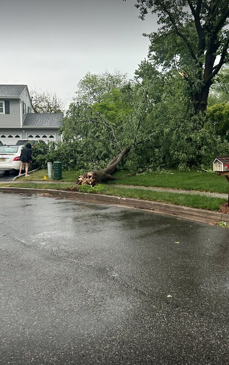
A big branch

-
A cop . Where’s the video .. where’s the pictures? Come on man
-
Apparently I'm losing already! Lol. Everyone around me had an inch a rain... meanwhile it's 92 and sunny here. I'll be surprised if we get any rain until next week.
-
Can't attach even low res screen shots. But storms splitting and going north and south of the Bergen bubble. Very dark to my south.
-
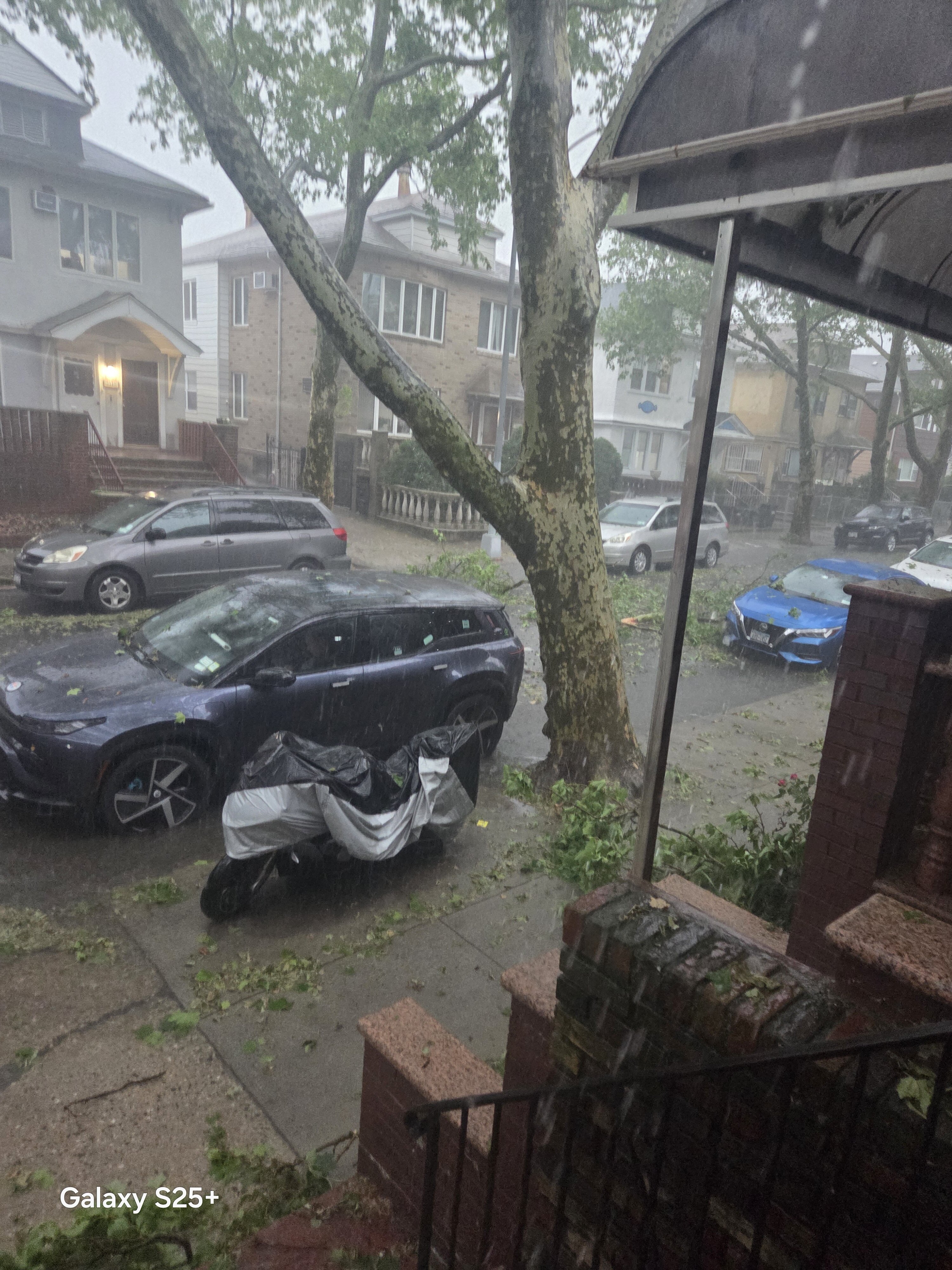
Heavy torrential rain here. Temp all way down to 69. Big tree just fell across the street from me. Its insane outside.
-
Heavy torrential rain here. Temp all way down to 69. Big tree branch just fell across the street from me. Its insane outside.

-
constant thunder, occasionally vivid CTC
-
You can tell just from the humidity, which has finally stuck around for a few days. Definitely seems like a pattern shift of sorts in progress.
-
Me too, though until yesterday I feel like RDUs readings have mostly matched surrounding areas this spring 94.3 here today, think RDU hit 95
-
Swing and a miss
-
My buddy in Piscataway sent me this. Decent sized tree. Hes in the Grandview area
-
Just to the north of the warned cell; lots of lightening at the field and soccer practice for my daughter is called. Not much for rain here; wet the dust.
-
Sad
-
Quick 20 degree drop
-
90 here today
.thumb.JPG.418e8a9a2902ae687ec35ff4bc0e038e.JPG)