All Activity
- Past hour
-
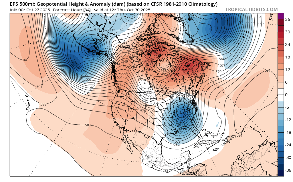
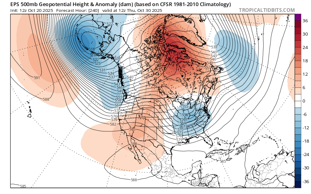
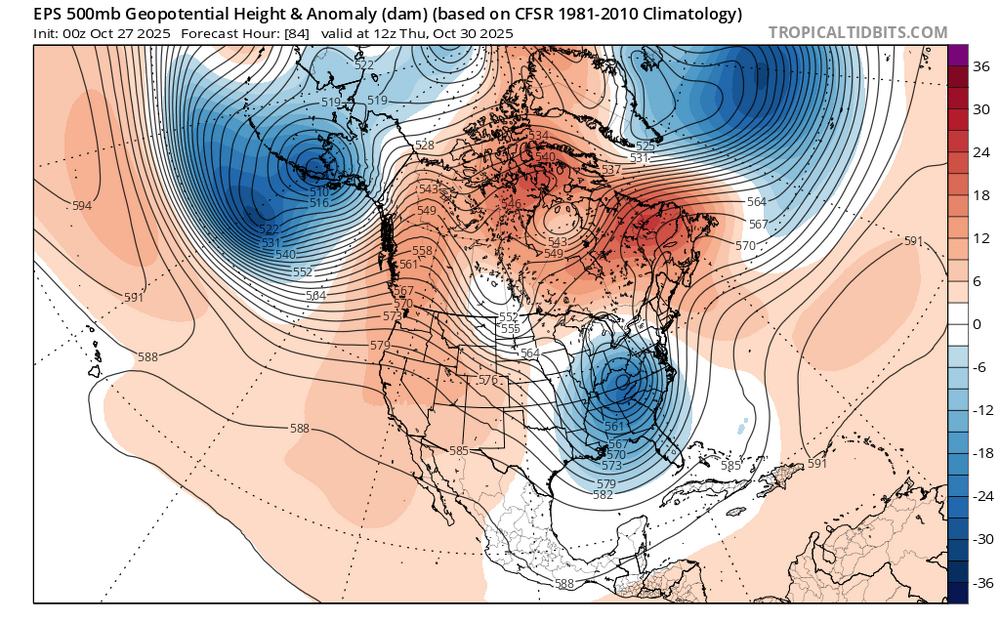
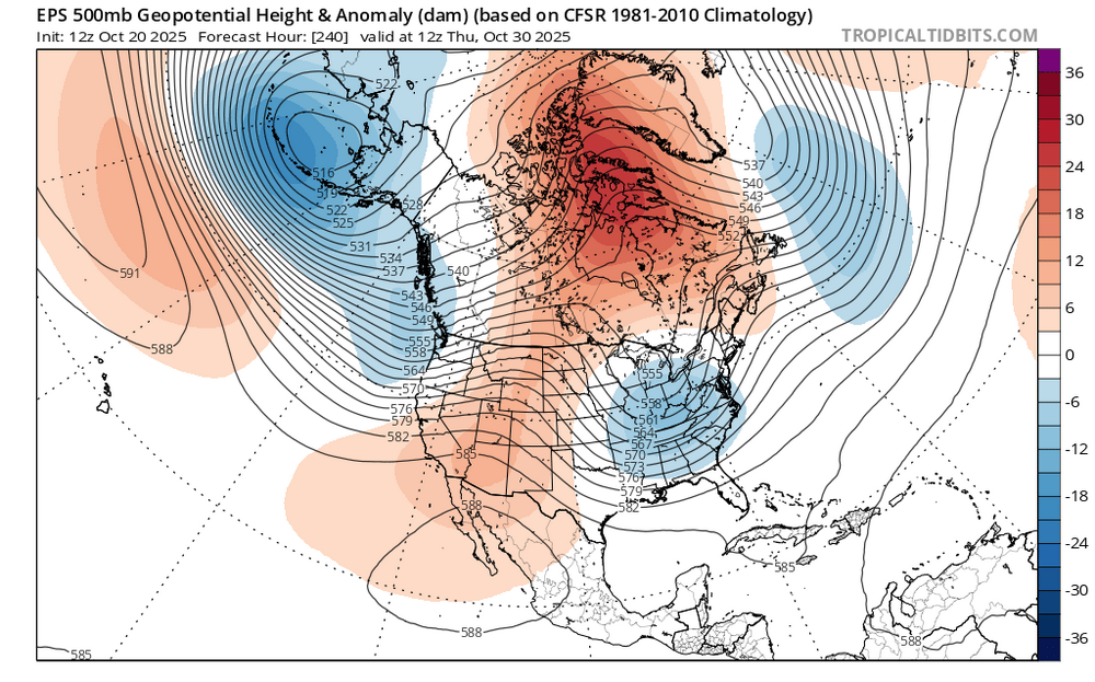
Even before we get to the cold season these strong -NAOs are still finding a way to link up with the Southeast ridge or WAR. The storm for this week was originally forecast to be a coastal storm track. But it has shifted to a warmer cutter track to our west. In the old days a -NAO +PNA would nearly always result in a classic coastal storm track since there wouldn’t have been a Southeast ridge or WAR. New run -NAO linking up with the WAR Old run no WAR
-

Spooky Season (October Disco Thread)
kdxken replied to Prismshine Productions's topic in New England
Yeah no warm weather in sight. Maybe May.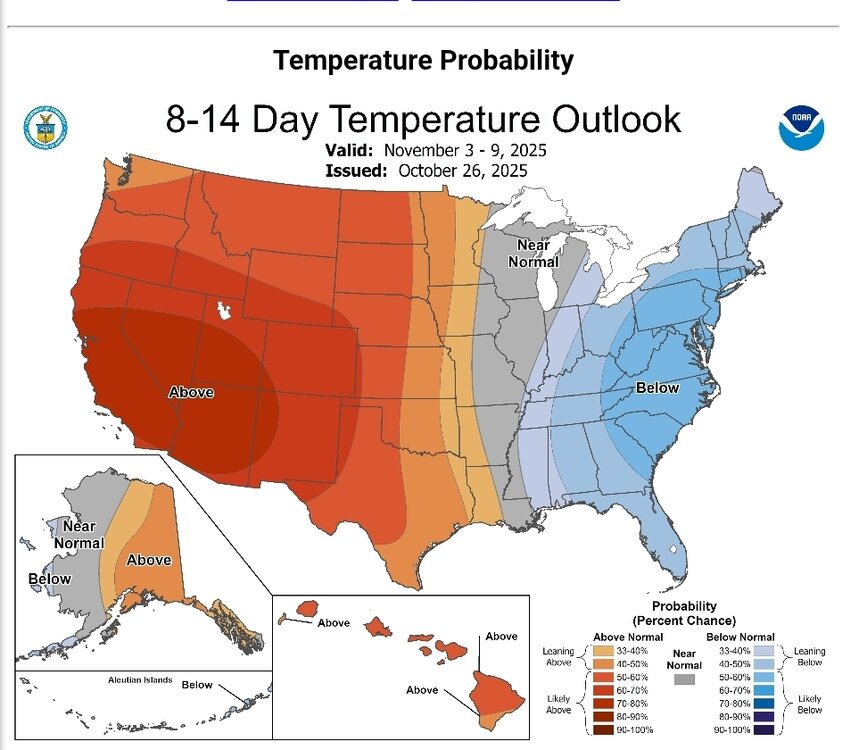
-
33.8 in Muttontown & 36.8 in Syosset this morning. Davis vantage vue around the corner from my Syosset station had 33.1 at 2am but I question it personally.
-
The weeklies/extended tools can be useful, but probably only for a week or so beyond day 15 on the ens run in most cases. Just my opinion based on experience. Not to say they can't have the right idea 30 days out but it's more of a crapshoot.
-

2025-2026 ENSO
40/70 Benchmark replied to 40/70 Benchmark's topic in Weather Forecasting and Discussion
I think he was more just focusing on that due to the +TNH/strong easterly QBO aspect....but yea, I'm not using it beause it was +ENSO. It is about as good of a QBO analog as you can get. -

Spooky Season (October Disco Thread)
Snowcrazed71 replied to Prismshine Productions's topic in New England
Looking ahead to next week... Looks like highs here for Tuesday and Wednesday will be in the 40's. -
Terpeast 2025-26 Winter Outlook - Edition 1
40/70 Benchmark replied to Terpeast's topic in Mid Atlantic
Nice job. Thanks. -
I can see 2013, 2014 though? Lol That was +ENSO and ++PDO
-

Spooky Season (October Disco Thread)
CoastalWx replied to Prismshine Productions's topic in New England
Still a little breeze -
Spooky Season (October Disco Thread)
CoastalWx replied to Prismshine Productions's topic in New England
35 here. Meh. -
2025-2026 ENSO
40/70 Benchmark replied to 40/70 Benchmark's topic in Weather Forecasting and Discussion
It kind of mirrors the impact CC is having on the cold season, whereas as have seen a greater incidence of classic blocking patterns during the shoulder seasons, opposed to the heart of it. -
I believe it’s already West of the official track.
-
This has been the pattern over the last decade. Early start to the season followed by a lull from late August into early September. Followed by a very strong late September to late October. So very challenging to get a low ACE season anymore with the record Atlantic SSTs and these historic RI and so many Cat 4-5 hurricanes.
-
2025-2026 ENSO
40/70 Benchmark replied to 40/70 Benchmark's topic in Weather Forecasting and Discussion
Wow...he is aggressive. Loves 2013 and 2014. -
Spooky Season (October Disco Thread)
Snowcrazed71 replied to Prismshine Productions's topic in New England
31 here this morning. -

Spooky Season (October Disco Thread)
CT Valley Snowman replied to Prismshine Productions's topic in New England
27 here -
 Update through 658A/27... no changes. Ensemble modeling continues similar with two groups..eastward wetter GEFS suites and slightly westward EC suites. Results are similar. I am not planning to work outside Thursday in northwest NJ, cleaning my gutters of leaves the day before-Wed AM... might need standby DVD in case of internet-power outage Thu afternoon as all modeled products this morning are similar to what we saw yesterday, including the high likelihood of coastal flooding with the Thu aftn-evening high tide cycle. 06z GFS went a little ballistic on qpf and that is related to the nearly stand still Thu aft-evening inflow pattern with PW over 1.5", caused by a suddenly intensifying 5H HFC across NJ---I cant figure the reasons for that... almost like a breathing 5H low HFC... 200M HFC TN Valley a day or two before, then weakens across VA and suddenly strengthens PA/NJ Thurs. IF it happens, I'd have to add an inland flooding tag to the thread and update ARI since this sole GFS cycle has spot 6" amounts in se NYS. I'm not buying that solution right now. One thread change that I may have to make is beef up the chance of iso svr ... but will wait til Tuesday evening before any adjusting.
 -
It’s really interesting how we also had great 11 year runs for snowfall in December and March also. OCT-NOV 2008 to 2018…DEC 2000 to 2010….MAR 2009 to 2019. Following each of those runs it was like someone shutting off a switch during the respective months. OCT and NOV haven’t featured any early season snows since 2018. Our last historic December snowstorm was Boxing Day in 2010. Interior sections near BGM in 2020 got their historic December snowstorm near 40” since the storm hugged the coast too close near ACY for us to get the really heavy totals. Then the big cutter a week later on Christmas with all the damage and flooding at the ski resorts. Then our least really big March with 30” on Long Island was 2018 and some areas did well in March 2019. Since then coastal sections have had nearly no March snow in the last 6 years.
-
When is it projected to turn north?
-
My point, again, only focusing on SSTs is that back in 2013, the areas that are and have been cooling now (GOA, along the west coast and off Baja) were warming very quickly at this time back then
-
Friends there did report it has been a warm fall.
-

Central PA Fall Discussions and Obs
mahantango#1 replied to ChescoWx's topic in Upstate New York/Pennsylvania
DT doesn't believe this will be a mild winter: The WxRisk Preliminary Winter Forecast 2025-26:as of 10/25/25https://tinyurl.com/4syrvdfw -
I grew up climbing Mount Washington and The Presidential Range. I have skied Tuckerman Ravine three years straight the years after college. Final time from the lip. Wicked cool, and scary as hell, going up and down. Took the left gully down, didn't fall. Have pix on my FB page. One shot climbing in the summer, "This mountain has some of the worst weather in the world. Turn back now if you are unprepared." I paraphrase, will dig up the photo. Highest wind speed ever recorded: 230 some odd MPH. Mount Washington is no joke.
-
Central PA Fall Discussions and Obs
mahantango#1 replied to ChescoWx's topic in Upstate New York/Pennsylvania
25 this morning. -
Yep, that Nov 2018 SWFE snow was totally unexpected and had the impact of a MECS given it was during rush hour and no one planned for it. Driving back to Long Beach from Melville was like a car zombie apocalypse. And it was bad all the way to the immediate shore. I think it was supposed to be a half hour of white rain that’s it.