All Activity
- Past hour
-
December total 1.95"...4.3" snowfall. Highest temp 58. Lowest 13 Snowiest Dec here since 2009, but 2017 was 4.2" so about the same. Annual totals for 2025... 40.37" precip. (Bit BN) 22.5" snowfall (AN) Highest temp 95, Lowest 4
-
Pleasant surprise to wake up to

-

New Years Day 2026 - 1st snows of the new year possible
karmac replied to Baroclinic Zone's topic in New England
Snow globe! . -

New Years Day 2026 - 1st snows of the new year possible
ORH_wxman replied to Baroclinic Zone's topic in New England
Incoming for PVD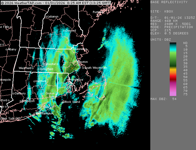
-
Columbia/east side: Dec precip imby: 1.63” (3.5” snow) Nov precip imby: 1.59”
-

New Years Day 2026 - 1st snows of the new year possible
tavwtby replied to Baroclinic Zone's topic in New England
was shocked to wake up to 3+" otg was only expecting flurries after that initial burst. so, does it count as a Dec snow or Jan? because I was out before midnight, no idea when it went through -

New Years Day 2026 - 1st snows of the new year possible
TauntonBlizzard2013 replied to Baroclinic Zone's topic in New England
Snowing pretty good. Obviously much weaker than what folks west got. Round 2 looks Mostly south of here -
.thumb.jpg.aec747d13df1d95d5fed34574f74d4fd.jpg)
New Years Day 2026 - 1st snows of the new year possible
Vinny Findley replied to Baroclinic Zone's topic in New England
Yeah it's here. Big fatties falling now with strong wind. -
January 2026 regional war/obs/disco thread
TauntonBlizzard2013 replied to Baroclinic Zone's topic in New England
“We just don’t know” -

New Years Day 2026 - 1st snows of the new year possible
codfishsnowman replied to Baroclinic Zone's topic in New England
I was just on the edge of the very good stuff and it was really impressive where I was at the time in Longmeadow. I figure that got them pretty close to an inch/ three quarters.....I expect some localized three inch squall totals to come out of Connecticut. It looked incredible on radar around 630. I will read the entire thread after work later. Driving all over the Springfield area Chicopee Falls looked to have the most snow with over an inch post synoptic and squall -
New Years Day 2026 - 1st snows of the new year possible
ORH_wxman replied to Baroclinic Zone's topic in New England
Gonna be a good round 2 for you -
I have no idea, I do know .5 here.
-
Is there a way to get snowfall obs for official climo sites yet? Anyone know what fell at the climo sites?
-
This is legit unlike the other ones.
-

E PA/NJ/DE Winter 2025-26 Obs/Discussion
Kevin Reilly replied to LVblizzard's topic in Philadelphia Region
Sunny a few passing clouds 25f humidity 52% dew point 10f Total snow from Snow Squall: 0.6” Total Snow for year: 9.4” -

New Years Day 2026 - 1st snows of the new year possible
The 4 Seasons replied to Baroclinic Zone's topic in New England
11.1 Dec, 11.5" season. Above normal snowfall, below normal temps and solid snowpack through new years, hard to complain about this winter so far but man this event was terrible, huge hole around here only 0.6" and 0.1" from the squall.. I'll have a town list totals up shortly, maps will come later. Probably a bunch of cocorahs after 7AM so will have to wait till tomorrow morning to get final numbers, esp across MA/RI. Unbelievably this makes this the fourth 3"+ event of the season that'll go up on the archive, i didn't think it would but there were many reports in CT alone over 3" -

New Years Day 2026 - 1st snows of the new year possible
Baroclinic Zone replied to Baroclinic Zone's topic in New England
Yeah, just looked at photo time stamp when squall hit. -

New Years Day 2026 - 1st snows of the new year possible
Fozz replied to Baroclinic Zone's topic in New England
1”, in 20 minutes? -
New Years Day 2026 - 1st snows of the new year possible
Baroclinic Zone replied to Baroclinic Zone's topic in New England
The snow growth in this is incredible. Quick 1” -
Wondering how the glass overflowing wolf will try to spin this one.
-
Roads are bad saw a brand new mustang go right into a pole.
-
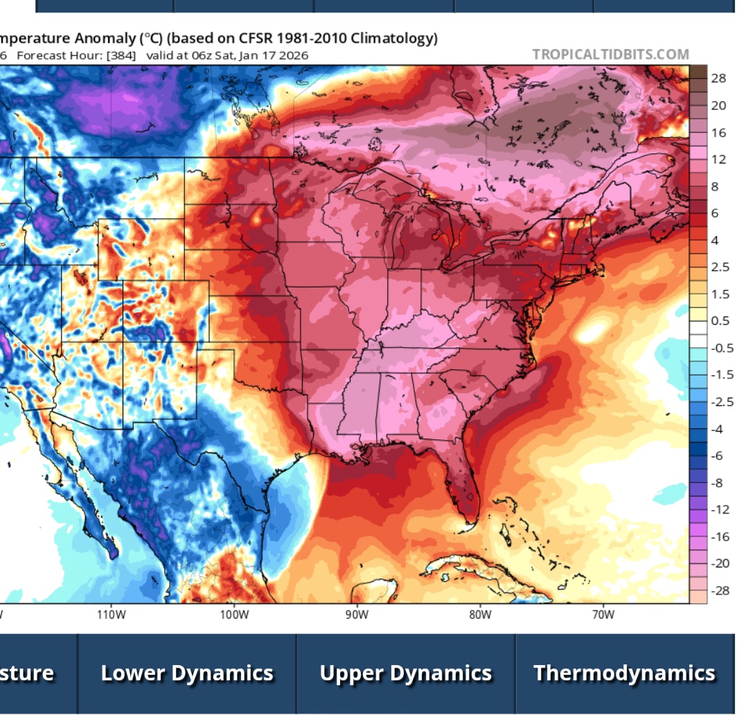
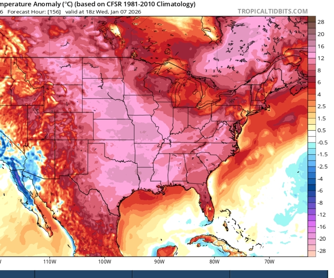
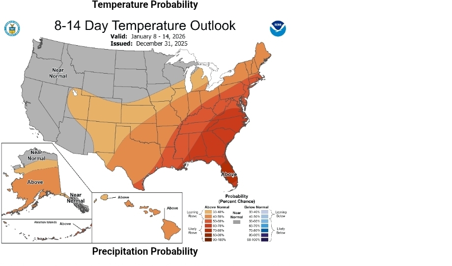
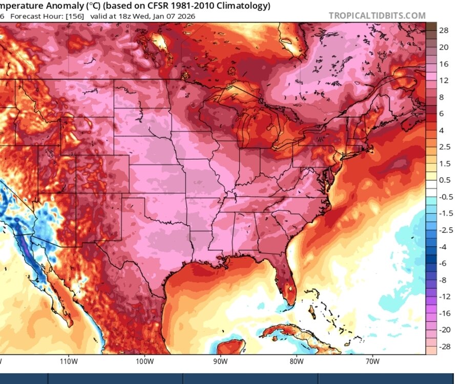
The 7th through the 17th. Not a cold look. 17th is 1st . Too lazy to change it.

-
Records: Highs: EWR: 63 (1973) NYC: 62 (1966) LGA: 60 (2019) JFK: 62 (1966) Lows: EWR: 6 (2018) NYC: -4 (1918) LGA: 8 (2018) JFK: 7 (2018) Historical: 1767: The morning temperature in Boston was -8°F 1864 - Snow, gales and severe cold hit the Midwest. It was the most bitter cold New Year's day of record with afternoon highs of 16 below zero at Chicago IL and 25 below at Minneapolis MN. (David Ludlum) 1864: A historic cold blast of air charged southeast from the Northern Plains to Ohio Valley. Chicago had a high temperature of -16°. A farmer near Huntertown, Indiana, reported the same high temperature as Chicago, with a low of 21 degrees below zero. He remarked "rough day" in his weather diary. Minneapolis had a temperature of 25 degrees below zero at 2 PM. St. Louis, Missouri, saw an overnight low of 24 degrees below zero. The Mississippi was frozen solid with people able to cross it. 1881: Lowest minimum temperature ever recorded in January for Washington, DC -14°F. The temperature reading was made at the weather bureau office at 24th and M Street, NW. The Naval Observatory in Washington, DC recorded -16.5 degrees Fahrenheit on this date. This same air mass gave the lowest temperature ever recorded in December on December 31, 1880 when a low of 13 below zero F was recorded. Thus, one air mass set the all-time record low temperature for the two months of January and December.(Ref. Washington Weather Records - KDCA) 1888: The Signal Corps office opened in Rapid City, South Dakota, on January 1, 1888. It was located in the Sweeney Building at the corner of 7th and Main Streets. The high and low temperature that day was 6 and -17°F. 1892: At Pittsburgh, Pennsylvania, dandelions were in bloom in parks. 1916: Rainmaker Charles Hatfield offered to bring rain to a parched San Diego, California for $10,000. He began to burn strange chemicals on this date to summon rain. It did begin to rain on January 10th. The problem was that it didn't stop raining for days and damaging floods resulted. The city refused to pay him the money. (Ref. AccWeather Weather History) 1918: The coldest period of the winter of 1917 and 1918 occurred from December 29th to January 4th. New England suffered through its coldest New Years Day in modern history. The temperature plunged to -32° at Van Buren, ME., -24° at Northfield, VT, -20° at Bethlehem, NH and -7° at New Haven, CT. Locations reporting daily record lows included: Hartford, CT: -8°, Boston, MA: -3°, Lexington, KY: 3°, Lynchburg, VA: 3°, Richmond, VA: 6°, Roanoke, VA: 8°, Wilmington, NC: 11°, Charlotte, NC: 11°-Tied, Raleigh, NC: 12°, Norfolk, VA: 12°, Jacksonville, FL: 21°, Pensacola, FL: 25°-Tied, West Palm Beach, FL: 35°, Miami, FL: 36° and Key West, FL: 51°. (Ref. Wilson - Additional Temperatures Listed On This Link) 1934 - Heavy rain which began on December 30th led to flooding in the Los Angeles Basin area of California. Flooding claimed the lives of at least 45 persons. Walls of water and debris up to ten feet high were noted in some canyon areas. Rainfall totals ranged up to 16.29 inches at Azusa, with 8.26 inches reported in Downtown Los Angeles. (The Weather Channel) 1935: The Associated Press Wire Photo Service made its debut, delivering the great weather maps twice each day to newspapers across the country. The first photo transmitted was a plane crash in the Adirondack of New York on this day. The plane crashed during the evening hours on December 28, but the rescue did not occur until New Year's Day. 1935: The Associated Press Wire Photo Service made its debut, delivering the famous weather maps, twice each day to newspapers across the country. (Ref. AccWeather Weather History) 1948: An ice storm glazed surfaces in Chicago, IL, with ½-1” ice; it was followed by 4”+ snow. Winds to 50 mph common (approx. 100 mph estimate at Glenview Naval Air Station) 11 radio station towers destroyed/damaged. 6,000 Western Union poles down; 5,500 miles of wire broken/tangled. (Ref. Weather Guide Calendar with Phenomenal Weather Events 2011 Accord Pub. 2010, USA) 1949: A six-day blizzard began over the Northern Rockies and the Great Plains. The storm produced the most adverse weather conditions in the history of the west. (David Ludlum) 1949 - A six day blizzard began over the Northern Rockies and the Great Plains. The storm produced the most adverse weather conditions in the history of the west. (David Ludlum) 1961: A three-day-long ice storm was beginning over northern Idaho, which produced an accumulation of ice eight inches thick, a U.S. record. Dense fog, which blanketed much of northern Idaho from Grangeville to the Canadian border, deposited the ice on power and phone lines, causing widespread power outages. 1964: A snowstorm struck the Deep South on December 31st, 1963, through January 1st, 1964. Meridian MS received 15 inches of snow, 10.5 inches blanketed Bay St Louis MS, and 4.5 inches fell at New Orleans, LA. The University of Alabama Head Football Coach “Bear” Bryant said that the only thing that could have messed up his team’s chances in the Sugar Bowl against Ole Miss in New Orleans, LA was a freak snowstorm. Well, much to his chagrin, 4.5 inches of snow fell the night before the big game. Alabama won the game 12-7 anyway. Freezing temperatures then prevailed for New Year’s Day. 1979 - The temperature at Maybell CO plunged to 60 degrees below zero to tie the state record set back in 1951 at Taylor Park. (The Weather Channel) 1984: A severe cold spell finally broke on New Year's Day at Topeka, KS when the mercury finally rose above 32° after 554 hours. An unprecedented cold spell set temperature records every morning from 12/18 to 12/25/1983. A deep snow cover kept temperatures at or below zero for a record-setting 95 consecutive hours from 12/21 – 12/25/1983. The lowest temperature of -17° occurred on 12/22/1983. (Ref. Wilson Wx. History) 1987 - A winter storm brought rain and snow and high winds to the Southern and Middle Atlantic Coast Region. The storm, which occurred in a period of unusually high astronomical tides, produced a tide of 9.4 feet at Myrtle Beach SC (their highest since Hurricane Hazel in 1954) which caused a total of 25 million dollars damage in South Carolina. (National Weather Summary) (Storm Data) 1988 - Arctic cold gripped the north central U.S. The morning low of 31 degrees below zero at Alamosa CO was a record for the date. Squalls in the Great Lakes Region produced 17 inches of snow at Elmira NY. (National Weather Summary) (Storm Data) 1989 - Those who woke up New Year's morning unable to see much farther than the end of their nose had a good excuse, at least in the central U.S., as dense fog prevailed from Texas to Wisconsin. (National Weather Summary) 1990 - The new year and decade began on a rather peaceful note. Snow was primarily confined to the Great Lakes Region, the Upper Ohio Valley, and the Sierra Nevada Range of California. Subzero temperature readings were confined to Minnesota and North Dakota. (National Weather Summary) 1994 - Strong winds along the eastern slopes of the Central Rockies gusted to 70 mph at Arlington WY, and gusted to 80 mph near Estes Park CO. Heavy snow in the northeast mountains of Oregon produced 14 inches at Tollgate. A series of storms the first three days of the year produced 20 inches of snow at Lowman, in the west central mountains of Idaho. (National Weather Summary) (Storm Data) 1997 - Heavy precipitation fell from December 26, 1996 to January 3, 1997 in much of the west. In the California Sierra Nevadas the Truckee River reached its highest level on record. Lake Tahoe reached its highest level since 1917. Sacramento was spared the worst of the flooding by a system of levees, although many nearby towns were not so fortunate. Numerous levee breaches and breaks occurred across the state. Approximately 16,000 residences were damaged or destroyed. State officials estimated at least $1.6 billion in damages to private and public property. 1999 - A major blizzard struck portions of the Midwest on January 1-3, 1999. The storm produced 22 inches of snow in Chicago and was rated by the NWS as the second worst blizzard of the 20th century, ranking behind the blizzard in January 1967. Estimates of losses and recovery costs are between $0.3 and $0.4 billion with 73 dead as a result of the blizzard. (NCDC) 1999: The start of 1999 was ushered in with snow, ice, and freezing weather across central and south-central Nebraska. On New Year's Day, a steady snowfall along and north of Interstate 80 dumped from 1 to 5 inches of snow. By late morning, freezing drizzle developed southeast of Hastings and eventually coated area roads with a layer of ice. Light snow later that evening made travel even more treacherous. Several accidents occurred on the Interstates and Highway 30. Once the ice and snow ended, arctic air spilled across the area abroad 20 to 30 mph north winds. Blowing and drifting of the fallen snow caused reduced visibilities for a time on the 2nd. Temperatures dropped to 5 to 15 below zero through midday the 3rd. 2002: Intense lake effect snow squalls buried sections of Lewis County in New York with tremendous snows. Snowfalls for the four day period ending on this day were 127 inches at Montague, 104 inches at Highmarket and 86 inches at North Osceola. The 127 inches at Montague is one of the greatest snowfalls ever recorded for a single lake effect snow event. (Ref. Wilson Wx. History) 2004: Sierra Mountains, California: Heavy snow derails a passenger car on the California Zephyr 40 miles west of Truckee. The westbound Amtrak train is detained for 14 hours by the weather and accident, stranding 300 people. (Ref. Wx.Doctor) 2009: A strong blizzard which began on New Years Eve continues to hit the Canadian Maritimes. The storm was characterized by very low barometer readings including: Sable Island, Nova Scotia: 966 millibars or 28.54 inches of mercury and Sidney, Nova Scotia, 970 millibars or 28.65 inches of mercury with strong winds. One gust in Halifax Harbor reached 85 mph. Charlottetown, Prince Edward Island was buried under 19.3 inches of snow while Yarmouth Airport, Nova Scotia received 16 inches of snow and Cheticamp, Nova Scotia, recorded 14 inches. (Ref. Wilson Wx. History) 2011: Southern and central Mississippi saw 11 tornadoes during the night of December 31st into the morning hours of January 1st. Of the 11, two were EF-3 with two more EF-2. Six were EF-1 with one EF-0.
-

January 2026 OBS and Discussion
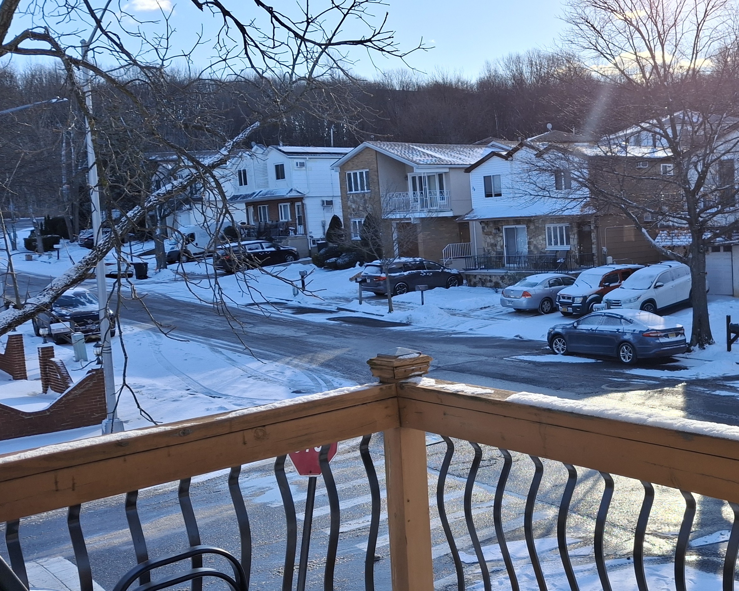
coastalplainsnowman replied to TriPol's topic in New York City Metro
Main story by me is that everything - the street, sidewalks, etc - are a slick sheet of ice. It's a crusty 1/4-1/2" of frozen combo. I was woken up by some gusts of wind while it was still dark out but fell back asleep. Now I know what it was. Caps off a start to meteorological winter that I would have gladly signed up for if you asked me in October. Happy New Year! All the best for a happy and a healthy 2026. -

New Years Day 2026 - 1st snows of the new year possible
Patfan1987 replied to Baroclinic Zone's topic in New England
Nice steady snow and then the wind came. White out in Dorchester for a few.