All Activity
- Past hour
-
We have been locked into a steady shower all day. Been pleasant to be honest.
-
Loving it
-
Quick count from the separated lists above: Daily record highs: 82 Daily record lows: 14 Total record events listed: 96 NYC Date Temp Year Jan 3 64°F 2000 Jan 4 66°F 2023 Jan 6 72°F 2007 Jan 9 64°F 2008 Jan 11 69°F 2020 Jan 12 68°F 2020 Jan 21 63°F 2006 Jan 29 69°F 2002 Jan 30 64°F 2006 Feb 6 68°F 2008 Feb 7 56°F 2020 Feb 8 62°F 2017 Feb 10 61°F 2023 Feb 11 65°F 2009 Feb 12 62°F 2018 Feb 17 68°F 2022 Feb 21 78°F 2018 Mar 3 68°F 2024 Mar 6 68°F 2022 Mar 7 74°F 2022 Mar 9 77°F 2016 Mar 10 80°F 2026 Mar 12 71°F 2012 Mar 18 77°F 2011 Mar 22 78°F 2012 Mar 23 76°F 2012 Mar 26 82°F 2021 Apr 6 80°F 2023 Apr 7 92°F 2010 Apr 13 90°F 2023 Apr 14 91°F 2023 Apr 15 90°F 2026 Apr 16 92°F 2002 Apr 17 96°F 2002 Apr 22 86°F 2001 Apr 23 86°F 2007 Apr 24 87°F 2001 Apr 26 92°F 2009 Apr 28 90°F 2009 May 1 87°F 2001 May 2 90°F 2018 May 3 92°F 2018 May 4 92°F 2001 May 7 93°F 2000 May 8 91°F 2000 May 18 92°F 2017 Jun 10 96°F 2008 Jun 12 93°F 2017 Jun 23 96°F 2025 Jun 24 99°F 2025 Jul 6 103°F 2010 Jul 7 100°F 2010 Jul 22 104°F 2011 Jul 23 100°F 2011 Jul 24 97°F 2010 Aug 3 97°F 2005 Aug 8 99°F 2001 Aug 9 103°F 2001 Aug 13 99°F 2005 Aug 17 95°F 2015 Aug 18 94°F 2002 Aug 19 94°F 2002 Sep 8 97°F 2015 Sep 24 91°F 2017 Oct 2 93°F 2019 Oct 8 87°F 2007 Oct 19 85°F 2016 Oct 24 79°F 2001 Nov 3 79°F 2003 Nov 6 75°F 2022 Nov 9 75°F 2020 Nov 10 74°F 2020 Nov 28 70°F 2011 Dec 1 70°F 2006 Dec 5 70°F 2001 Dec 6 71°F 2001 Dec 11 66°F 2021 Dec 13 67°F 2015 Dec 14 67°F 2015 Dec 15 68°F 2015 Dec 17 62°F 2000 Dec 20 60°F 2002 Dec 21 65°F 2013 Dec 22 71°F 2013 Dec 24 72°F 2015 Dec 25 66°F 2015 Dec 28 65°F 2008 Lows Date Temp Year Jan 7 4°F 2014 Jan 16 1°F 2004 Feb 14 -1°F 2016 Feb 20 2°F 2015 Mar 3 11°F 2003 May 8 36°F 2020 May 9 34°F 2020 May 20 43°F 2002 Jul 2 56°F 2001 Nov 8 29°F 2019 Nov 10 25°F 2017 Nov 11 24°F 2017 Nov 12 25°F 2019 Nov 13 23°F 2019
-
NYC Month Record High Year(s) Record Low Year(s) January 72°F 2007, 1950 -6°F 1882 February 78°F 2018 -15°F 1934 March 86°F 1998, 1945 3°F 1872 April 96°F 2002, 1976 12°F 1923 May 99°F 1962 32°F 1891 June 101°F 1966, 1934 44°F 1945 July 106°F 1936 52°F 1943 August 104°F 1918 50°F 1885, 1965, 1976, 1982, 1986 September 102°F 1953 39°F 1912 October 94°F 1941 28°F 1936 November 84°F 1950 5°F 1875 December 75°F 1998 -13°F 1917
-
After a brief warm up and drying out 5/ 26 - 5/28, next cut off / trough 5/29 - 5/31 - onshore and perhaps more heavier rain
-
Records: Highs: EWR: 98 (1992) NYC: 96 (1941) LGA: 94 (1992) JFK: 94 (2021) Lows: EWR: 44 (2002) NYC: 42 (1907) LGA: 47 (1950) JFK: 43 (1990) Historical: 1876 - Denver CO was drenched with 6.53 inches of rain in 24 hours, an all-time record for that location. (The Weather Channel) 1911 - The temperature at Lewiston ME soared to 101 degrees. It was the hottest temperature ever recorded in New England during the month of May. (David Ludlum) 1987 - A powerful tornado virtually wiped the small southwest Texas community of Saragosa off the map. The twister destroyed eighty- five percent of the structures in the town killing thirty persons and injuring 121 others in the town of population 183. The tornado hurled trucks and autos through adobe and wood- frame homes, with some vehicles blown 500 feet. (The National Weather Summary) (Storm Data) 1988 - Thunderstorms produced severe weather over the Central Gulf Coast States. Tennis ball size hail was reported at Ripley MS. Showers and thunderstorms in southern Missouri produced 3.20 inches of rain at Springfield to easily surpass their rainfall record for the date. (The National Weather Summary) (Storm Data) 1989 - Unseasonably hot weather continued in southern Texas and parts of the southwestern U.S. Seven cities reported record high temperatures for the date, including El Paso TX with a reading of 100 degrees. Presidio TX was the hot spot in the nation with a high of 111 degrees. (The National Weather Summary) 1990 - Late afternoon and evening thunderstorms developing ahead of a cold front in the north central U.S. produced severe weather from northwestern Kansas to central Minnesota and southeastern North Dakota. There were twenty-nine reports of damaging winds, or dime to golf ball size hail. Strong thunderstorm winds gusted to 69 mph at Alexandria, MN. Showers and thunderstorms over eastern North Carolina soaked Wilmington with 2.91 inches of rain, which established a record for the date. (The National Weather Summary) (Storm Data) 1998: Greeley, Brush, and Fort Morgan, CO, raked by hail to 2 inch diameter; a woman hurt when hail broke through home’s window. Roofs collapsed in Brush; 140,000 acres of area crops devastated. Cars stuck in hail to 18 inches deep until snowplows could clear roads. (Ref. Weather Guide Calendar with Phenomenal Weather Events 2011 Accord Pub. 2010, USA) 2002: An unusual late season frost in the North Carolina Mountains caused significant damage to the Christmas tree crop. 13 inches of snow fell at Cooke City, MT through the 23rd. (Ref. Wilson Wx. History) 2004: A F4 tornado tracked 54 miles through Jefferson, Saline, Gage, Lancaster, and Otoe Counties in Nebraska. 95% of the buildings in the town of Hallam were destroyed or severely damaged. The tornado was 2.5 miles wide at one point. One person was killed, 38 injured, and damages totaled $160 million dollars. (Ref. Wilson Wx. History) 2011: The Joplin Tornado was reported to have developed directly over Joplin with the first report of the tornado in Joplin at 5:41 pm CDT, 5/22. Latest reports from mid-day Tuesday 5/24 indicate an estimated 118 fatalities and several hundred injured in the Joplin, MO area. The Joplin tornado is the deadliest since modern record keeping began in 1950 and is ranked 8th among the deadliest tornadoes in U.S. history. The tornado surpassed the June 8, 1953, tornado that claimed 116 lives in Flint, Mich., as the deadliest single tornado to strike the U.S. since modern tornado record keeping began in 1950. The deadliest tornado on record in the U.S. was on March 18, 1925.
-
66 / 40 onshore flow - thicker clouds to the south. Ugly fest will ensure Sat / Sun cool - clouds rain >1.5 inches to 3 inches in spots - more especially northern areas. Perhaps we dry out PM Sunday and perhaps pokes of sin for memorial day. Much wearmer / ncer Tue - Thu then omega-like patterns forces next cut off ULL down backing into the area next wekeend 5/28 - 5/31 period. Onshore / cooler perhaps more rain 5/29-5/31. Ridging expanding eat by first week of June. 6/5 - beyond - next shot at 90s in that period.
-
one of the ten best days of the year cool gusty wind feel like early november..
-
Had to put this forecast up for Asheville:
-
...they got their wish lol.....and now they are watching that monster growing in the pacific..
-
it did end early it was over after the 2/25 storm. March was a nationwide torch
-
...Just wait till next Christmas to get the 75 degree day! Early Merry Christmas to all of the people who spent the winter of 25-26 bitching about the cold and wanting an early end to winter..lol #BECAREFULWHATYOUWISHFOR
-
.56"
-

Central PA Spring 2026 Discussion/Obs Thread
mahantango#1 replied to Voyager's topic in Upstate New York/Pennsylvania
Seen last week a coal company in Schuylkill county said they are raising. prices $20.00 a ton for all coal sizes i think starting next week. Because of fuel prices to operate the equipment and trucking costs. And they said if fuel prices don't drop till near fall they will have raise them again. They were giving a heads up for people to get coal now. -
Just awful. Can we get a 75 degree day please? LOL
- Today
-

2026-2027 Strong/Super El Nino
Stormchaserchuck1 replied to Stormchaserchuck1's topic in Weather Forecasting and Discussion
57-58 and 65-66 also didn't have a strong east-based orientation. Since 1948, only 5 events: 72-73, 82-83, 97-98, 15-16, and 23-24 have been basin wide Super Nino. Kind of interesting that this will be the 3rd one in 12 years, in the midst of many weaker La Nina's. -
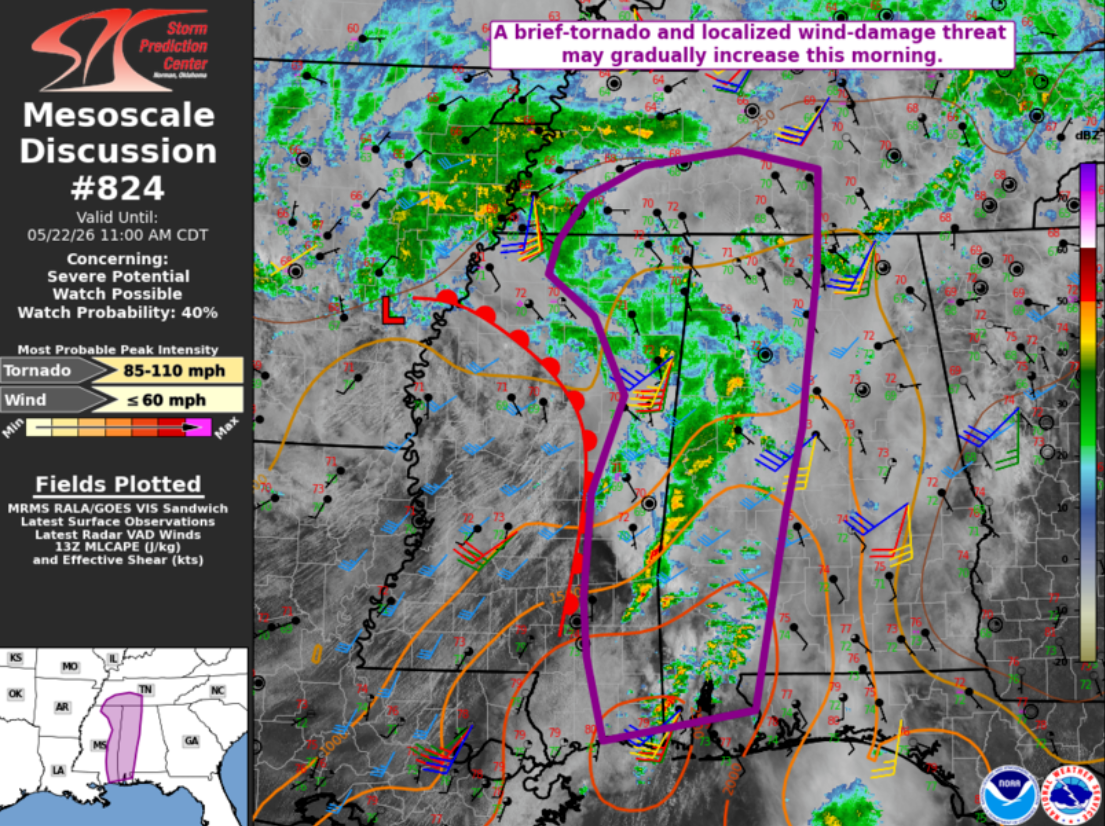
If northeast Alabama into northwest Georgia can push 80 degrees this may expand east. I still think Tennessee will be too messy. We'll see about Tenn. Crossville likes to Crossville these skinny CAPE low level shear days. Upper Plateau gets first crack at the LLJ. Otherwise, as of 10:30 Central Time, a west-east differential heating boundary is noted from Birmingham to Atlanta. Northward lift will depend on precip.

-
Absolutely fantastic for many outdoor activities.
-
Central PA Spring 2026 Discussion/Obs Thread
mahantango#1 replied to Voyager's topic in Upstate New York/Pennsylvania
Let's see if it comes to fruition. -
I consider Alaska's southeast coast the worst climate in the country. Today's weather in the DC area is quite possible on the Fourth of July there, except with 40 mph southwest winds. Juneau once had 51 consecutive days with measurable rainfall.
-
Ditty's winter moths doing some damage. Enough of them so you can hear them crapping.

-
Wasn't expecting this extended dry period this morning, I'm taking advantage and doing some outdoor stuff until the next batch comes in.
-

2026-2027 Strong/Super El Nino
40/70 Benchmark replied to Stormchaserchuck1's topic in Weather Forecasting and Discussion
Yea, I know what you mean. 1957 and 1965 were very good here, but they were kind of borderline strong versus super. -
(002).thumb.png.6e3d9d46bca5fe41aab7a74871dd8af8.png)
Central PA Spring 2026 Discussion/Obs Thread
ChescoWx replied to Voyager's topic in Upstate New York/Pennsylvania
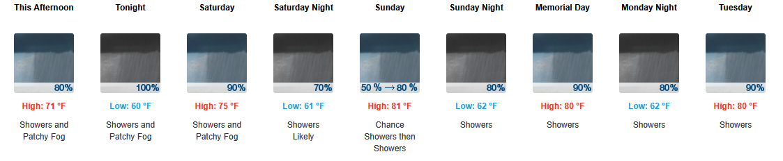
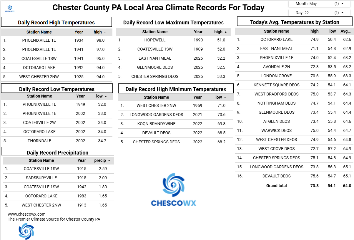
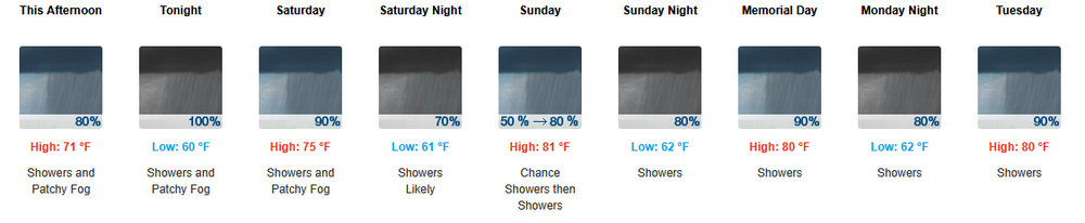
Happy Memorial Day Weekend! Unfortunately weather wise it will be wet and almost record cold especially tomorrow afternoon. Most models now keep temperatures below 50 degrees tomorrow afternoon - this would break the Chester County record for low maximum temperatures for the date set back in 1982. There is a chance it could be the coldest late season high temperature on record. With gusty winds it will feel a lot more like early March than Memorial Day Weekend. Rain-wise models show between an inch to as much as 3.5" of much needed rain!
-

2026-2027 Strong/Super El Nino
michsnowfreak replied to Stormchaserchuck1's topic in Weather Forecasting and Discussion
To clarify...I meant 1982-83 was the absolute shittiest winter of the bunch here. I grew up with my winter-hating dad saying he remembers how "great" that winter was. My mom (who loves winter) was pregnant with me and said she remembers feeling sick at Christmas Eve midnight mass because it was warm in her coat. It was pretty much on its way to being the least snowy winter on record, with only 9" falling thru March 19, but then two spring snowstorms (Mar 21 & Apr 17) added 11" so the winter finished at 20". No winter since has seen that little snowfall. Also, it still stands as the least snowy astrononomical winter on record with only 5.8" falling Dec 21-Mar 19. 1957-58 and 1965-66 at least had some cold, white stretches but were also absolutely atrocious snow years. In fact, both finished UNDER 20" of snowfall. I only give them the nod above 1982-83 since they had some cold & white stretches in winter. With the abysmal snowfall, as you would imagine, the snowdepth was only 2-3" during these wintry stretches 1997-98 and 2023-24 sucked overall, but were better than 1957-58, 1965-66, and 1982-83. 1972-73, 1987-88, 1991-92, 2015-16 all had some fun winter stretches and while none of them were great winters Id take any of them in a heartbeat over the others.