All Activity
- Past hour
-
Gfs worthless at this point.
-
the way the HRRR is trending soon it’ll show 6” for everybody lol
-

12/14: Sunday funday? Will the south win again?
stormtracker replied to TSSN+'s topic in Mid Atlantic
Yup. Ya ninja'd me. I posted SV showed the same. Not made at it -

December 14th - Snow showers or Plowable snow?
ORH_wxman replied to Sey-Mour Snow's topic in New England
18z gfs ticking NW too -

Moderate snowfall 12/14/2025 WWA up for most of the area
Tatamy replied to WeatherGeek2025's topic in New York City Metro
My station out at Fire Island popped up to the 40s earlier. Since 2:00 PM when the wind subsided and backed around from SW to W the air temperature has dropped 6 degrees to 36 and the DP down 4 degrees to 31. No big ocean warming looks to happen at this point. -

12/14: Sunday funday? Will the south win again?
SnowenOutThere replied to TSSN+'s topic in Mid Atlantic
Dog, Imma be so real with you I haven't been paying attention to this storm till literally around noon today. Yesterday I wrote a 10 page paper in a day (nailed it btw) and the day before that I did my atmosphere and weather final (crushed it as well) so I have not had time to go into the dynamics of this stuff sadly. Though from a very quick overview the latest HRRR has the trough a little bit deeper and position a bit souther which helps get everything moving quicker. A consequence of this change is that positive temp advection is more favored for our area (which encourages diffusion aloft and surface lift). Here is the 20z HRRR temp advection vs the 18 -

Central PA Winter 25/26 Discussion and Obs
Itstrainingtime replied to MAG5035's topic in Upstate New York/Pennsylvania
Oh absolutely! I just had to laugh at that particular depiction. -

12/14: Sunday funday? Will the south win again?
MillvilleWx replied to TSSN+'s topic in Mid Atlantic
Likely has to do with the sharper 5H trough and a really pronounced 3H jet dynamics with the RER of the jet. This is classic for a dynamic system that will likely invoke a few surprises. The CAA regime involved will also be sufficient for improving ratios as the event rolls through. If this event happens next month, we’d be looking at some wide spread warning chances imo. In any case, this is shaping up to be a nice event for many in here. The northern crew has been hosed in recent years. This will be a nice event to get on the board. -

12/14: Sunday funday? Will the south win again?
NorthArlington101 replied to TSSN+'s topic in Mid Atlantic
GFS spreads out the goods more then 12z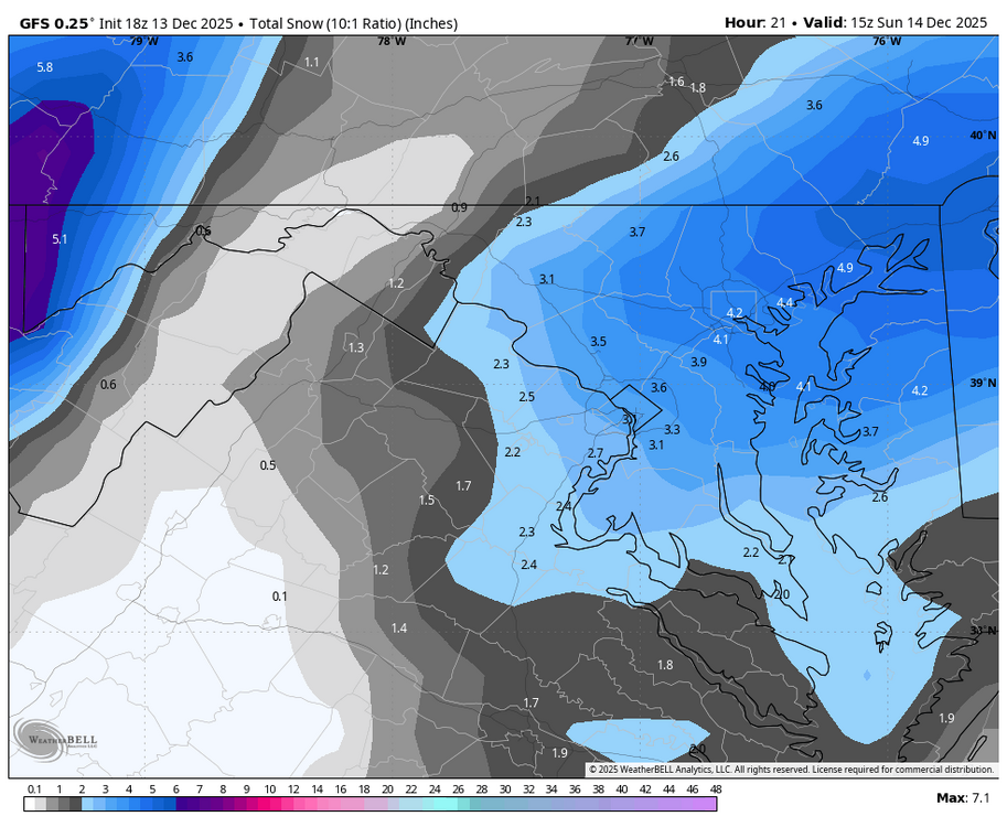
-
You guys are due for sure.
-

12/14: Sunday funday? Will the south win again?
Whitecheddar replied to TSSN+'s topic in Mid Atlantic
Light rain/sleet mix started in Hagerstown. -

Moderate snowfall 12/14/2025 WWA up for most of the area
dseagull replied to WeatherGeek2025's topic in New York City Metro
Cant ask for much more in terms of early season snowfall on the coast. Had 37 degree water temps inside the inlet. 42 one mile off, and 48 seventeen miles off where we were fishing. Friends that went deep dropping in the Tom's Canyon earlier in the week still touched 58-60 in several spots. Grateful this isnt an onshore wind setup, with the early season warm (relatively) warm water. Hope everyone gets to enjoy, and get some pictures with the snow and christmas lights/decorations. -
 Cloudy. 28.8
 -
12/14: Sunday funday? Will the south win again?
SnowenOutThere replied to TSSN+'s topic in Mid Atlantic
If this goes well for our area real credit has got to be given to the RGEM and Canadian models. The 18z keeps the good vibes going as well -
@SnowenOutThere curious to hear your take as to what’s causing the HRRR beef up the past 3-4 runs
-

December 14th - Snow showers or Plowable snow?
WalpoleJoe replied to Sey-Mour Snow's topic in New England
You must have a.beautiful location....Fond memories on that pond....we had a house on Great Island for many years, great pond for boating with access to go anywhere.....Great Island has changed so much since we sold.....too much NY and CT money moved in, changed the character.....sorry for off topic. -

Moderate snowfall 12/14/2025 WWA up for most of the area
qg_omega replied to WeatherGeek2025's topic in New York City Metro
Chances NYC gets 3 inches, 50 percent? -
I never focus on having the most and that wasn't complaining. Same here. I was all set to be thrilled for 3"
-
The product is "Lightning flash density" and thus with lightning would come thunder!
-
12/14: Sunday funday? Will the south win again?
stormtracker replied to TSSN+'s topic in Mid Atlantic
Keep creeping back south and east with that heavier stuff...give us 2 more ticks -

Winter 2025-26 Medium/Long Range Discussion
Frog Town replied to michsnowfreak's topic in Lakes/Ohio Valley
Here’s the issue. It’s like having a warm early May, then a cooldown leading up to the June solstice, and declaring that summer is over and not coming. Playing devil’s advocate, though—winter is cumulative and depends on a cold source and upstream snowpack. Summer doesn’t necessarily rely on those same factors to still turn out hot, even if there’s an early “snowball” effect to cool things down prior to the solstice. -

December 2025 Short/Medium Range Forecast Thread
Golf757075 replied to John1122's topic in Tennessee Valley
Just a pattern that sets up a better overlap of cold and precipitation. Thankfully it's still mid December -

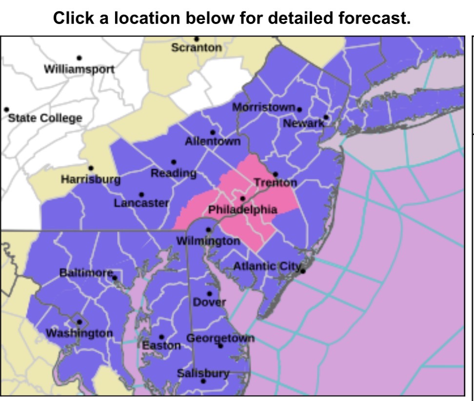
Saturday night/Sunday 12/13-12/14 Jawn
The Iceman replied to Ralph Wiggum's topic in Philadelphia Region
It’s beautiful
-
12/14: Sunday funday? Will the south win again?
SnowenOutThere replied to TSSN+'s topic in Mid Atlantic
That the model shows lightning flash density. To be honest I have no idea what makes lightning happen (neither did my professor the best we have is a separation of negatively charged graupel and ice crystals in a convection cell). Though I'm sure the strong lift throughout the column and positive temp advection in the 700mb layer have something to do with it. -
Beefin up