All Activity
- Past hour
-
Peeing mentally upon the legs of weenified souls while calling it rain will not make it rain. Because because the models!
-

Wednesday Feb 18 Mixed event. NoP refresher?
CoastalWx replied to HoarfrostHubb's topic in New England
Reggie is a whiff. Lol -

Wednesday Feb 18 Mixed event. NoP refresher?
ineedsnow replied to HoarfrostHubb's topic in New England
Lol REGGIE -

Wednesday Feb 18 Mixed event. NoP refresher?
Kitz Craver replied to HoarfrostHubb's topic in New England
0.0 from this at my location, well not exactly. Expecting rain -
Also, we have had snow cover for weeks and it still isn’t totally melted. I’m sure the ground is still a good bit colder than it otherwise would have been through this thaw thanks to the snowmelt going straight into it. Roads may be a tougher ask but then again, snow and white rain before CCB snow is probably a nightmare for treatment.
-
Wednesday Feb 18 Mixed event. NoP refresher?
ineedsnow replied to HoarfrostHubb's topic in New England
Probably 4 or 5 of mashed here -
This area has been 40-43 the past 3 days. Still will be 45-50 in parts of SNE today.
-

Late February/Early March 2026 Mid-Long Range
SomeguyfromTakomaPark replied to WxUSAF's topic in Mid Atlantic
Little early to worried about ratios, gimme this precip distribution all day any day. -
cold arctic/warm mid latitudes pattern we saw back in 2020.
-

E PA/NJ/DE Winter 2025-26 Obs/Discussion
MickeyTim6533 replied to LVblizzard's topic in Philadelphia Region
just playing around lol -
Canadian deterministic also has huge storm surge though a bit south. Its ensemble has some great hits
-

Is we back? February discussion thread
RUNNAWAYICEBERG replied to mahk_webstah's topic in New England
I mean the highs here rest of week are in the 40s so…while not as hot, still a warmup. -
Wednesday Feb 18 Mixed event. NoP refresher?
CoastalWx replied to HoarfrostHubb's topic in New England
You’re close to nothing or 2-3”. I’d say maybe C-2” -
Thanks for posting that. Will it get the dip right this time? It busted with those runs having it very weak around 2/10-15. So far this month the weakest has been down only to 19 m/s.
-

“Cory’s in NYC! Let’s HECS!” Feb. 22-24 Disco
Typhoon Tip replied to TheSnowman's topic in New England
I think by the year 2130 airline flighting will have long become an outmoded method for transportation. Go ahead and schedule the time away … -
If we are under the ccb if this storm even exits on Sunday, I’m not worried about ground temps. We would have better ratios than that super cold storm in January.
-

E PA/NJ/DE Winter 2025-26 Obs/Discussion
PhiEaglesfan712 replied to LVblizzard's topic in Philadelphia Region
What do you mean by debbie downer? I was saying 4-6 inches for this area. By the way, here was that snowstorm:
-

E PA/NJ/DE Spring 2026 Obs/Discussion
The Iceman replied to PhiEaglesfan712's topic in Philadelphia Region
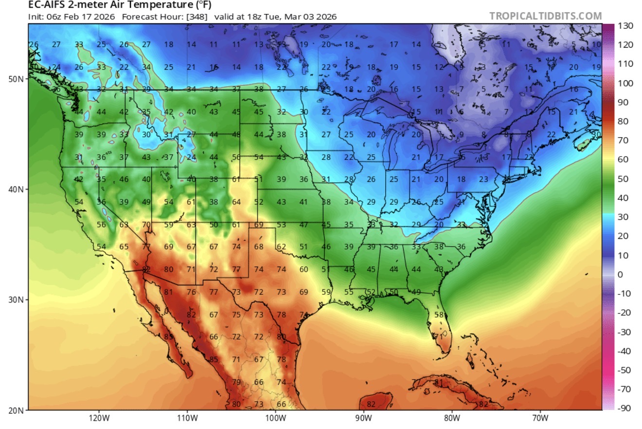
I’m going to lmao if this verifies. So much for 70s the first week of march.
-
Hey guys I’m not sure if anyone has also factored in how many cars will be out on the roads. Temps, soil, angle of the cold, blazing sun have all been mentioned. But we really need to think about all the SUVs and minivans making it rain
-
“Cory’s in NYC! Let’s HECS!” Feb. 22-24 Disco
ineedsnow replied to TheSnowman's topic in New England
LFG!! 12z runs up -
“Cory’s in NYC! Let’s HECS!” Feb. 22-24 Disco
Typhoon Tip replied to TheSnowman's topic in New England
So reminiscent. Like a favorite song. I recall the D6 MRF ensemble mean in the days before Apr 1997 looked just exactly like that, having those members along with uncertainty pulling W. Just looking at this and I’m taken back in time. … God I need to get laid -
(002).thumb.png.6e3d9d46bca5fe41aab7a74871dd8af8.png)
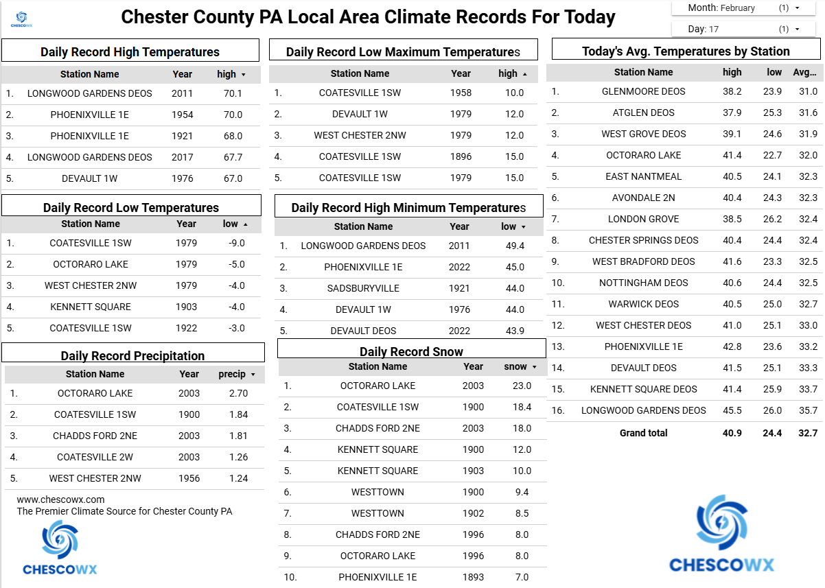
Central PA Winter 25/26 Discussion and Obs
ChescoWx replied to MAG5035's topic in Upstate New York/Pennsylvania
Fog should burn off later this morning, and we turn much milder with highs well into the 40's our normal high is still in the low 40's. After today there is at least a chance of rain each day with maybe some snow mixing in on Thursday night. Our heaviest rain looks to be on Friday, and we can really use the rain. There will no doubt be rumors of a snowstorm starting next Sunday....but the good news is we don't shovel snow rumors!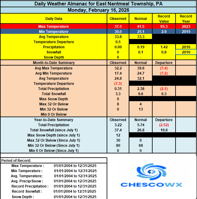
-
HGEFS (AIGEFS plus GEFS) has a mean of ~0.7QPF for the event with temps looking good from 925mb and up. Definitely would struggle with temps in the middle of the event for the metros but still a chance it remains snow as depicted, just bad accumulations. But a snow, to white rain, to snow again from CCB for a near warning level event would be pretty nice for a Miller B here. And finishing on clean snow would hide the slushy layer. I think it would also get Baltimore to about climo?
-
E PA/NJ/DE Winter 2025-26 Obs/Discussion
ChescoWx replied to LVblizzard's topic in Philadelphia Region
Fog should burn off later this morning, and we turn much milder with highs well into the 40's our normal high is still in the low 40's. After today there is at least a chance of rain each day with maybe some snow mixing in on Thursday night. Our heaviest rain looks to be on Friday, and we can really use the rain. There will no doubt be rumors of a snowstorm starting next Sunday....but the good news is we don't shovel snow rumors!
-
E PA/NJ/DE Winter 2025-26 Obs/Discussion
PhiEaglesfan712 replied to LVblizzard's topic in Philadelphia Region
Phase 3 is still cold in late February. I think exiting 3/entering 4 is the sweet spot for a snow event, though the pattern should change for the warmer after the event.