All Activity
- Past hour
-

January 2026 regional war/obs/disco thread
40/70 Benchmark replied to Baroclinic Zone's topic in New England
Number one analog is female.....place that innie on the outtie and it's a dude. -

Ice Ice Baby December 28-29 Storm Discussion
DavisStraight replied to Baroclinic Zone's topic in New England
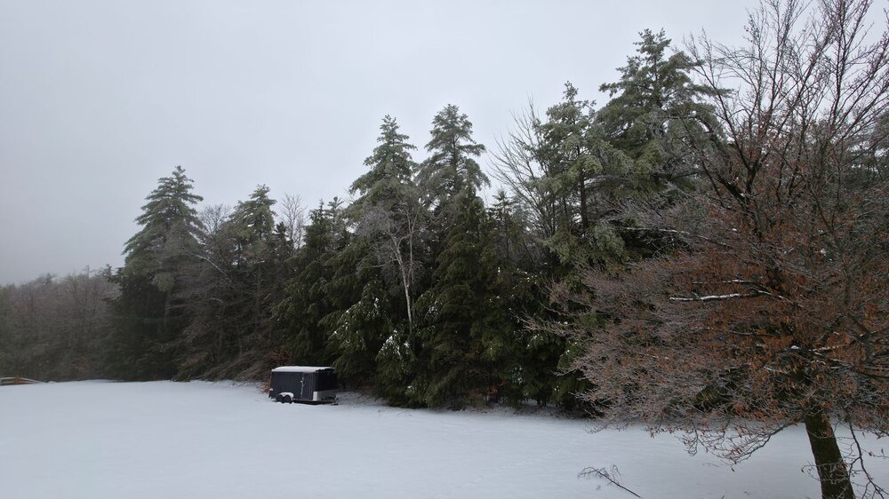
Still a decent pack, mine looks like Swiss cheese. -

January 2026 regional war/obs/disco thread
ORH_wxman replied to Baroclinic Zone's topic in New England
I do…if operational runs aren’t showing 288 hour blizzards, people get antsy regardless of whether the longwave setup looks nice….its a weird manifestation of the last 5 years. Nobody used to give a shit about whether we had 300 hour storms but now a significant portion of the forum gets anxiety over it. It’s probably because of the lack of KUs in that time period. Somehow, seeing them on the OP runs in clown range is some kind of crutch I guess. -

January 2026 regional war/obs/disco thread
CoastalWx replied to Baroclinic Zone's topic in New England
Oh missed that, sorry. Yeah it was a strange one. -

January 2026 regional war/obs/disco thread
Sey-Mour Snow replied to Baroclinic Zone's topic in New England
Ya I mentioned that above, it was weird , Got WNE and Eastern New England but skunked CNE -
January 2026 regional war/obs/disco thread
CoastalWx replied to Baroclinic Zone's topic in New England
Yeah I thought after the 6th (perhaps starting on the 6th) pattern looked conducive. Is it perfect? No, but I don’t see the angst from some. -
January 2026 regional war/obs/disco thread
CoastalWx replied to Baroclinic Zone's topic in New England
12/26/10 was also great here but had arctic sand in between here and the Berks. But that was an odd one because the deformation band certainly got deep into SNE, it’s just that there was not much in between Boston and the Berks. -
Super tall residential skyscrapers are hubris on a new level.
-
January 2026 regional war/obs/disco thread
Sey-Mour Snow replied to Baroclinic Zone's topic in New England
Thank you .. I don't know where the stigma comes that NYC snow is bad for SNE.. There are plenty of good ones that get great bands into CNE and Maine.. Feb 2006, Feb 2013, Jan 1960.. -
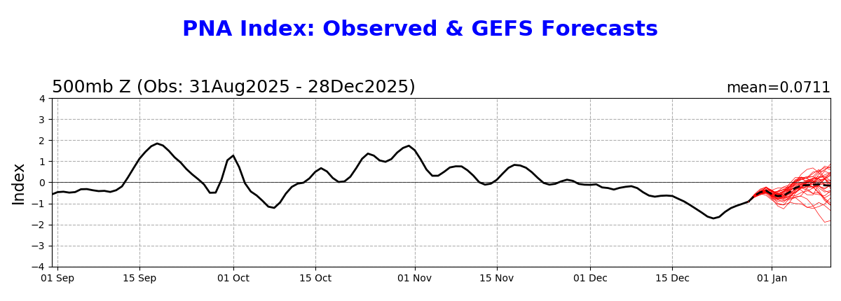
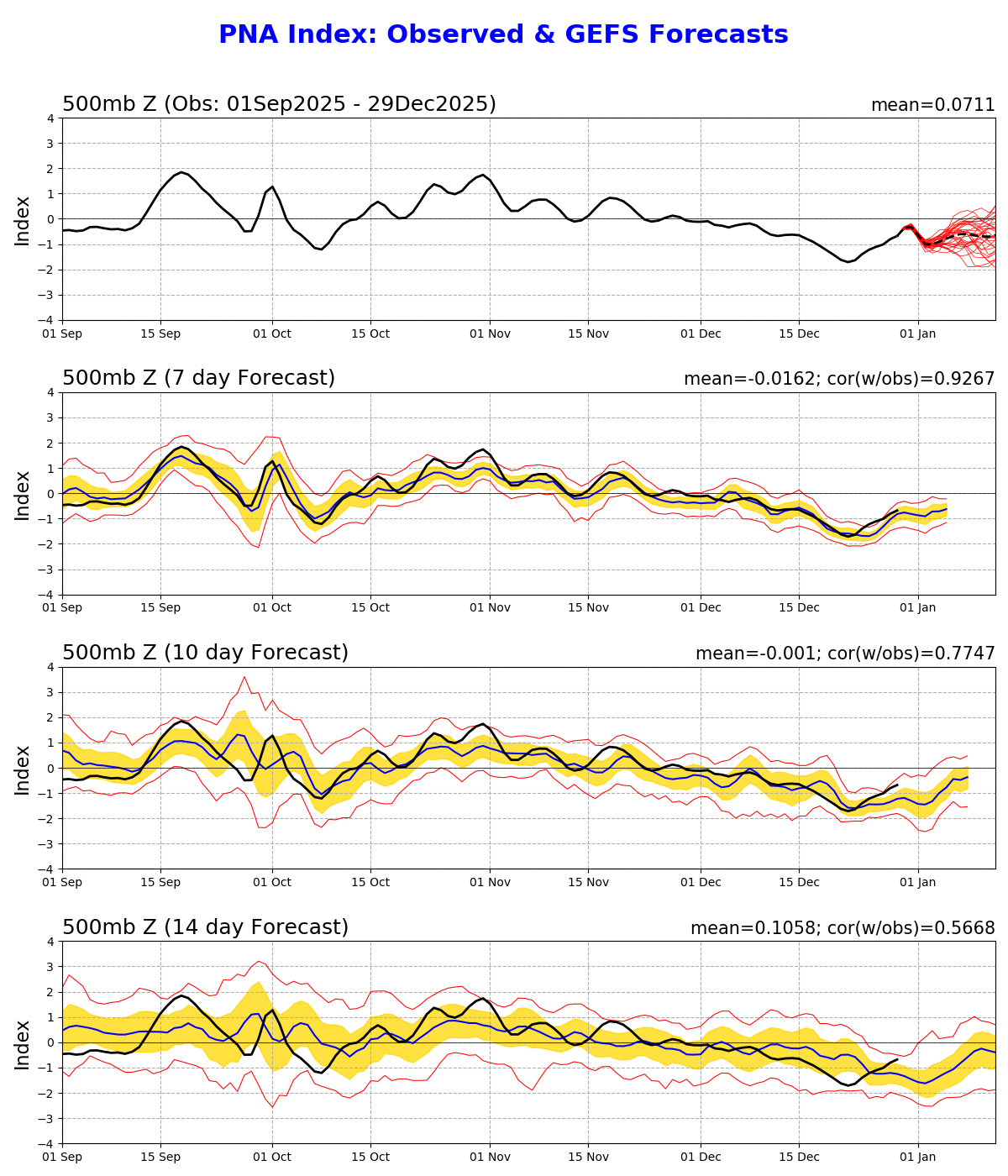
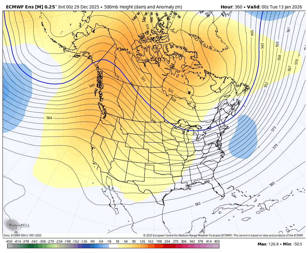
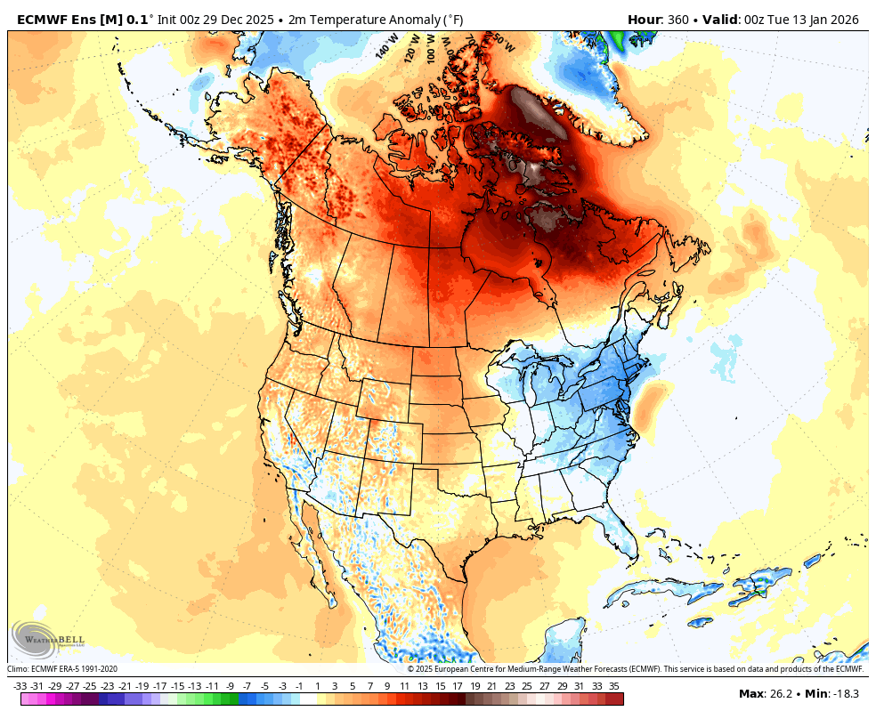
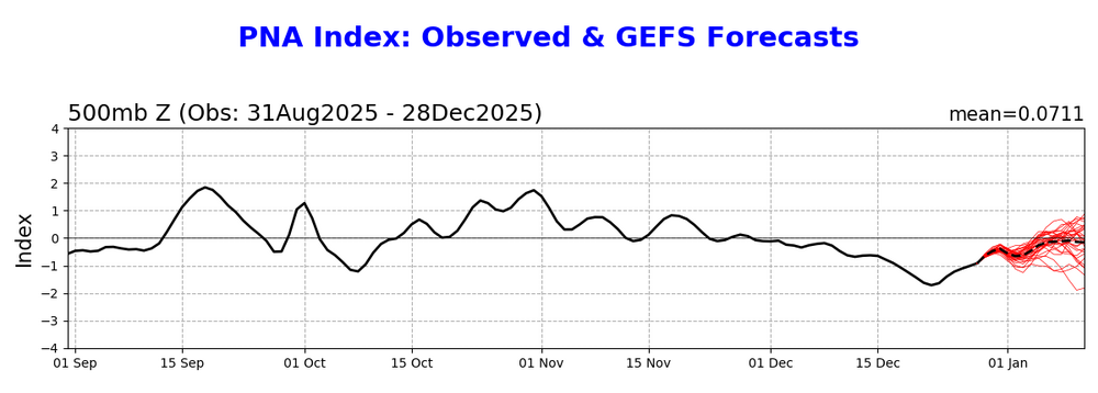
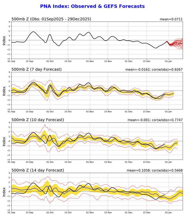
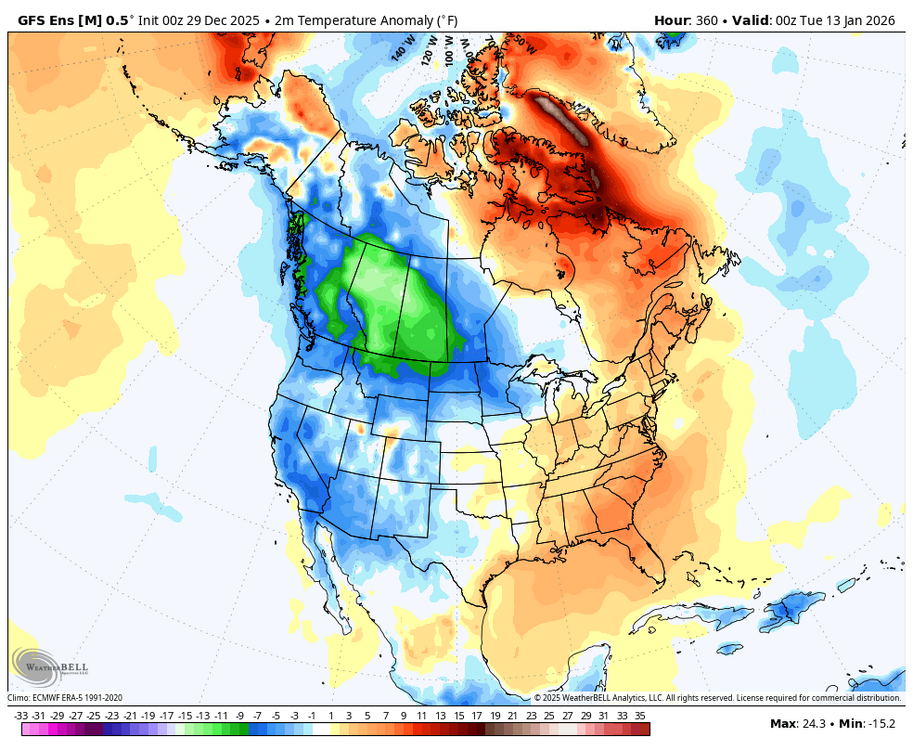
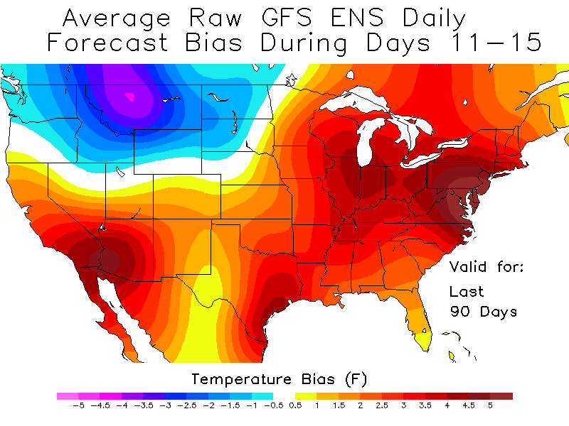
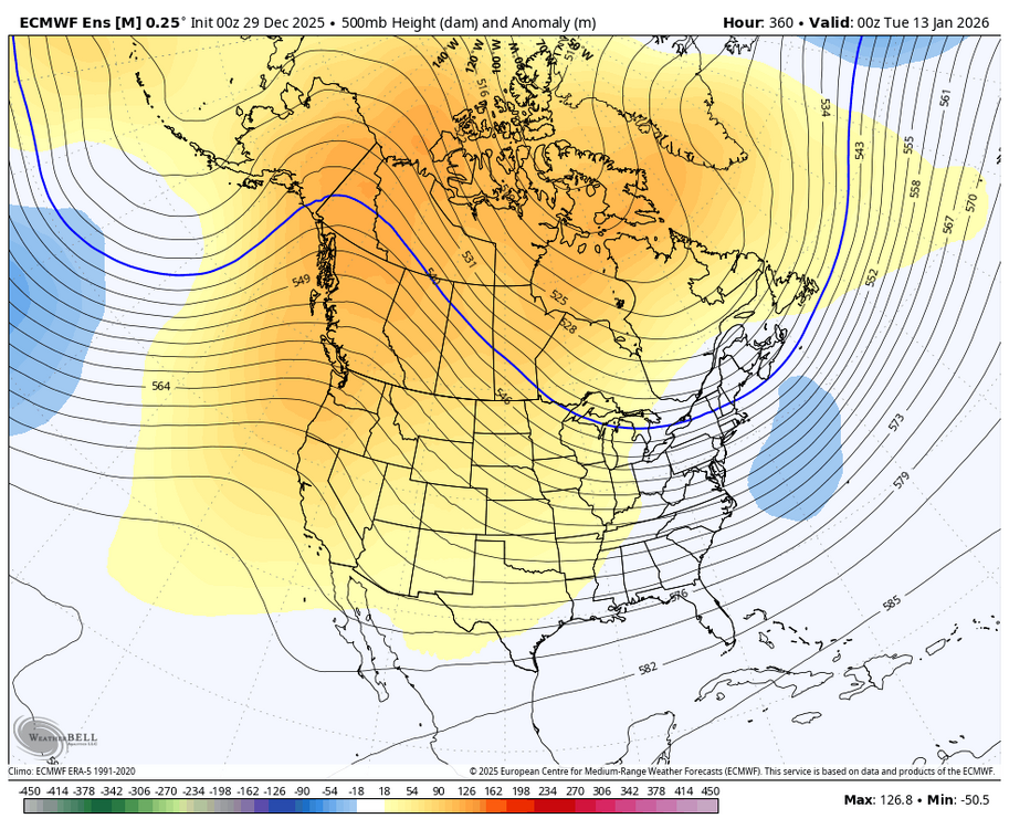
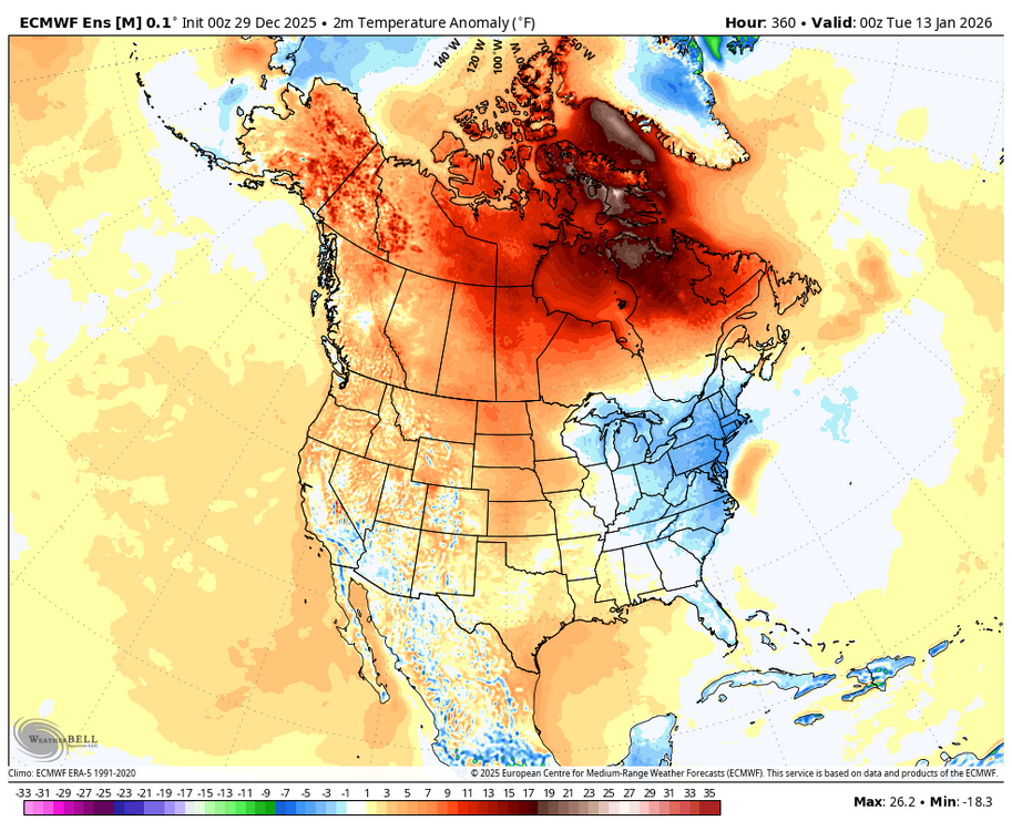
The 0Z EPS (another run with a transition to a +PNA and a chilly E US) and the 0Z/6Z GEFS (staying -PNA and a warm E US) are in different worlds for mid Jan. The CPC GEFS forecasts of yesterday vs today show a bad 24 hour trend if you want it cold in the E US in mid-Jan: Yesterday’s GEFS PNA forecast was heading up/nice trend vs earlier runs: Today’s 0Z GEFS said never mind, I’ll stay -PNA through the end of the run: yuck GEFS 0Z 360 hour 2m temps: mild in E US with the cold way out to the NW….yuck But the good news is that the GEFS has had a persistent -PNA and warm E US bias over the 90 day period for this map: And the EPS, a better performing and recently steadier ensemble, still has a +PNA and a chilly E US:
-

January 2026 regional war/obs/disco thread
weatherwiz replied to Baroclinic Zone's topic in New England
Very odd. I was just looking at bufkit, both NAM and GFS for BOS and it is going to rip tomorrow. Even the NAM which tends to undermix has gusts > 50-55 mph. -
January 2026 regional war/obs/disco thread
ORH_wxman replied to Baroclinic Zone's topic in New England
If DC gets hit big is usually is less impressive here but there’s been plenty that hit us very hard that hit NYC too (Feb ‘78, April ‘82, Jan ‘11, Jan ‘18, etc off the top of my head) -

January 2026 regional war/obs/disco thread
Chrisrotary12 replied to Baroclinic Zone's topic in New England
EPS looks solid for the 8th -
Latest spc meso analysis has a 120kt jet about to enter western PA and WV. Might see some legit winds west of I-81 today.
-
January 2026 regional war/obs/disco thread
CoastalWx replied to Baroclinic Zone's topic in New England
BOX loves those href clown wind maps that always target the ORH hills -

Ice Ice Baby December 28-29 Storm Discussion
VivaManchVegas replied to Baroclinic Zone's topic in New England
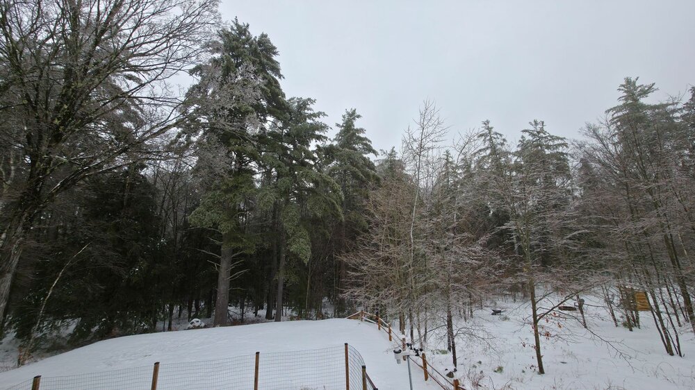
About 1/8" of ice. 32.4 degrees here at 300 feet. Hopefully we get a few hours above freezing to eliminate any possible damage from the winds.
-
January 2026 regional war/obs/disco thread
weatherwiz replied to Baroclinic Zone's topic in New England
Surprised the HWW doesn't go out to eastern Mass for tomorrow -
January 2026 regional war/obs/disco thread
Sey-Mour Snow replied to Baroclinic Zone's topic in New England
5 days pre Boxing Day 2010 is number one analog for the 00z EPS Day 10.. Scoring a .93.. Eastern Mass scored 10-20" .. Place that storm 50-100 miles east and this forum gets 20-32" -
Crappy way to run a Holiday torch.
-

Central PA Winter 25/26 Discussion and Obs
Mount Joy Snowman replied to MAG5035's topic in Upstate New York/Pennsylvania
the future.... HGEFS (Hybrid-GEFS): A pioneering, hybrid "grand ensemble" that combines the new AI-based AIGEFS (above) with NOAA’s flagship ensemble model, the Global Ensemble Forecast System. Initial testing shows that this model, a first-of-its kind approach for an operational weather center, consistently outperforms both the AI-only and physics-only ensemble systems. HGEFS — the most innovative application in the new suite. The HGEFS is a 62-member "grand ensemble" created by combining the 31 members of the physical GEFS with the 31 members of the AI-based AIGEFS. Performance: by combining two different modeling systems (one physics-based, one AI-based), the HGEFS creates a larger, more robust ensemble that more effectively represents forecast uncertainty. As a result, the HGEFS consistently outperforms both the GEFS and the AIGEFS across most major verification metrics. A NOAA first: to our knowledge, NOAA is the first organization in the world to implement such a hybrid physical-AI ensemble system. Area for future improvement: NOAA continues its work to improve HGEFS’s hurricane intensity forecasts. -
Ice Ice Baby December 28-29 Storm Discussion
Chrisrotary12 replied to Baroclinic Zone's topic in New England
Yeah we always tend to rot longer than expected at 32.2* in these scenarios -

Ice Ice Baby December 28-29 Storm Discussion
Sugarloaf1989 replied to Baroclinic Zone's topic in New England
Same here. Fog and 33F. -

Pittsburgh/Western PA WINTER ‘25/‘26
ChalkHillSnowNut replied to Burghblizz's topic in Upstate New York/Pennsylvania
I’m under a WWA for 2-6 from 1pm today-1pm tomorrow….. -
The schtick from the same actors is tiresome. I know I've contributed to that discourse in the past, but I've tried to stop it as best I can.
-

Ice Ice Baby December 28-29 Storm Discussion
AstronomyEnjoyer replied to Baroclinic Zone's topic in New England
Dumping rain at 32.0°. Lovely.