All Activity
- Past hour
-
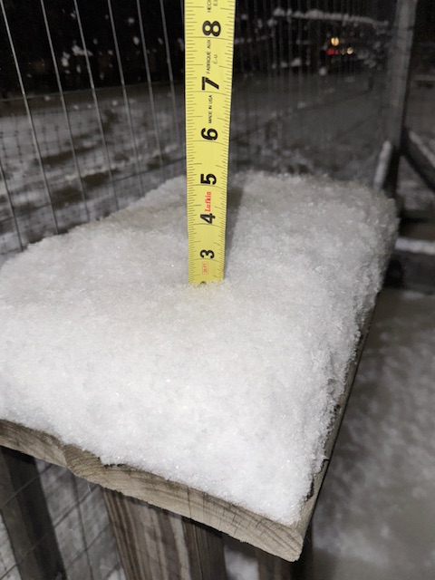
Yeah nice 2.25” of fluff stacked nicely on all the trees and even power lines. Looked festive driving home from Waterbury. It wants to snow this year.
-
The upcoming pattern looks favorable for New England. This is different than the early December period, climo is no longer hostile now that it is late December.
-

December 2025 regional war/obs/disco thread
WxWatcher007 replied to Torch Tiger's topic in New England
Like Tip talks about all the time—it’s not just about the result. The model cinema matters too for many. (No shot at anyone, we all want to see blue bombs) -

December 2025 Short/Medium Range Forecast Thread
Carvers Gap replied to John1122's topic in Tennessee Valley
I will re-respond. Mercy! Cold source. Check. -

December 2025 Short/Medium Range Forecast Thread
iluvsnow replied to John1122's topic in Tennessee Valley
Here is a link to current coldest temperatures on the planet. I tried to copy and paste the top 15, but it didn't work....so go to the link and peruse for yourselves. Canada does have some of the top 15 low temps on earth for the date. We should also remember that its only December 22nd. The really bottom level stuff in the Northern Hemisphere doesn't occur until late January and February up top. This is pretty rare for Canada to have lows this cold, this early......the link: https://eldoradoweather.com/climate/world-extremes2/world-temp-rainfall-extremes.php -

December 2025 regional war/obs/disco thread
WinterWolf replied to Torch Tiger's topic in New England
You don’t say? -

December 2025 regional war/obs/disco thread
TauntonBlizzard2013 replied to Torch Tiger's topic in New England
Is that favorable thing in the room with us? Because I can totally envision a scenario where we get porked tomorrow and then whiffed Friday -

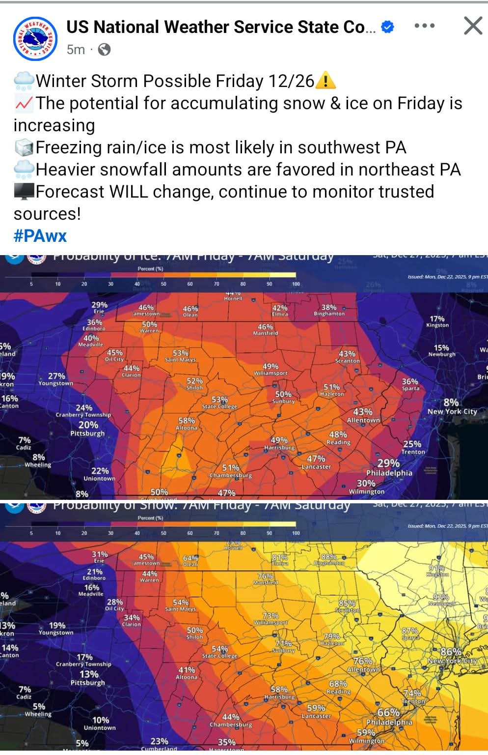
Central PA Winter 25/26 Discussion and Obs
Voyager replied to MAG5035's topic in Upstate New York/Pennsylvania
I got you. Here it is... hopefully.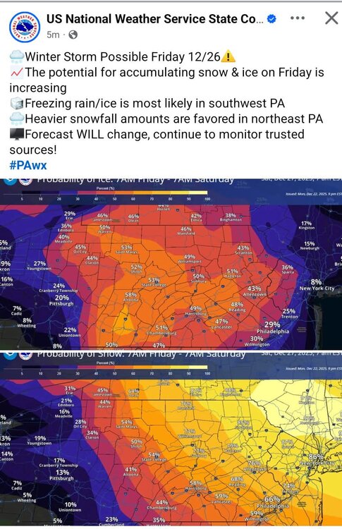
-
December 2025 regional war/obs/disco thread
WinterWolf replied to Torch Tiger's topic in New England
Nobody should be aggravated with a system that’s 4 days away, and that was raining here just yesterday. Does anybody ever learn anything? When was the last time we knew what a potential winter system could bring (especially a system that could bring wintry precipitation) at 4 days out? Answer: never. -
I'm ready! New coil for the Trump class snowblower (formerly known as an Ariens).
-
December 2025 Short/Medium Range Forecast Thread
Carvers Gap replied to John1122's topic in Tennessee Valley
I found this analog in the d6-10 analogs of CPC. 1-7-94. I could see that being usable. John always has to remind me of that winter. I had to go back and look it up. Sure enough, that winter I had to drive to campus on frozen interstates for about a week. My apartment started leaking as water backed up under the ice. It may be a reach on my part, but that analog makes some sense, and it has fit recent winters. I don't know its ENSO state, but that might be one to think about. -
Fortunately, it seems that the big warmup coming around Christmas and through new years was overestimated by the models. It looks like most of the northeast and mid Atlantic will remain with near normal temperatures and New England will remain a bit colder than normal. That being said the warmth during Christmas week across the country is literally like the inverse of the Arctic air outbreak during Christmas 2022. But either way, this is almost just as impressive with temperatures in the 80s all the way up to Nebraska today. Spring to summer like weather this week for much of the heartland and the south. Fortunately, it doesn’t appear that will be reaching us during this last week of December. Hopefully all the record cold air bottled up in Canada in Alaska can spill down next month across the country and bring some renewed snowfall chances. Because aside from our snowfall chances here in the northeast, much of the country will remain warm and dry for the foreseeable future.
-
Too early to say. But that means something must go favorable for us.
-

Central PA Winter 25/26 Discussion and Obs
anotherman replied to MAG5035's topic in Upstate New York/Pennsylvania
-

White Christmas Miracle? December 23-24th
CoastalWx replied to Baroclinic Zone's topic in New England
can’t be negative to Wolfie. He doesn’t like to hear it. -

White Christmas Miracle? December 23-24th
Sey-Mour Snow replied to Baroclinic Zone's topic in New England
It's a white rain to a coating for everyone then some IVT develops for Eastern New England after sunset.. Just another model.. I think there will be some surprises when we wake up, hopefully they are good.. -

Central PA Winter 25/26 Discussion and Obs
Ruin replied to MAG5035's topic in Upstate New York/Pennsylvania
current radar precip looking way ahead of schedule and very spotty/dry too? -
Whaaaa cluttering up a thread that’s 244 pages long? how the hell can you tell LOL
-
December 2025 regional war/obs/disco thread
TauntonBlizzard2013 replied to Torch Tiger's topic in New England
I do feel his frustration, honestly. This system was raining to the Canadian border and moved like a thousand miles in two runs, and now has stabilized as a Mid Atlantic hit. I don’t blame people for being aggravated if Philly is getting a foot this weekend -
White Christmas Miracle? December 23-24th
WinterWolf replied to Baroclinic Zone's topic in New England
So what are you saying…it’s much later with any snow? -
1947 was 26.4" (26.1" on 26th) and 2010 was 20.0" (12.2" 26th + 7.8" 27th). That 7.8" portion is the daily record for the 27th. The 12.2" on 26th would have been a daily record on every day of December except the 15th (12.7" fell in 1916), the 20th (15.5" fell in 1948), but even without 1947, not the 26th .... 18 inches fell in 1872 on Dec 26th during a very cold spell. Boxing Day seems good for snow, I think Don showed it was the most likely date in December to see measurable snow, and other significant falls include 7.0" in 1890, and 11.2" in 1933. In 1969 there was 6.3" over the 25th and 26th. The three largest December totals for two days all include the 26th.
-
December 2025 Short/Medium Range Forecast Thread
Carvers Gap replied to John1122's topic in Tennessee Valley
I am gonna tag @John1122in this. His records are easily the best and most uncorrupted that I know of. They are rigorous and have good fidelity to boot(they are his family's for those who don't know). He might be able to shed some light on Maue's thoughts and hopefully chip in some insight. John, I am not asking you to support or criticize RM...just to add some context to the cold forecast in Alaska and in relation to our area. -

Central PA Winter 25/26 Discussion and Obs
WmsptWx replied to MAG5035's topic in Upstate New York/Pennsylvania
Too goddamned large lol -
December 2025 regional war/obs/disco thread
WinterWolf replied to Torch Tiger's topic in New England
He might be getting worse than his neighbor in Taunton. Poor SOB Needs a serious break. -
Central PA Winter 25/26 Discussion and Obs
Voyager replied to MAG5035's topic in Upstate New York/Pennsylvania
Ha. Just screenshotted it, and was going to post it.