All Activity
- Past hour
-
I've been busy putting on a new roof for my aunt I had the last couple days off why? I still think its going to be close
-
About to leave the house soon anyways.
-
Let’s see what stein does.
-
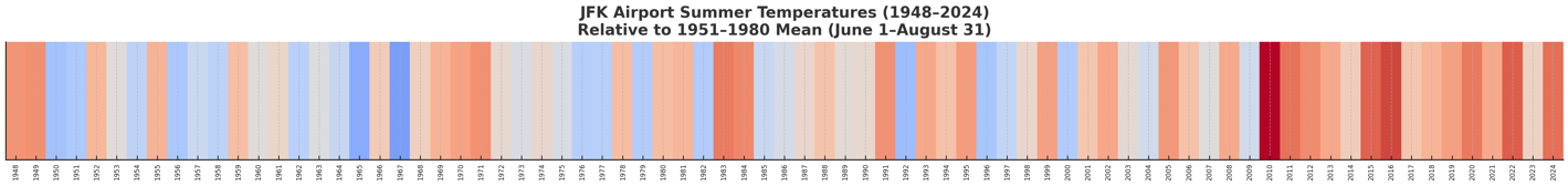
 Yes 2010 really stands out on these color coded charts Don. Don, is there a way to rank summers like we rank winters aka the WSI? If so I'd like to rank summers in terms of extreme temperatures, duration of heatwaves, highest average temperature, highest mins, highest dewpoints, etc. Is there some way to factor in all the dimensions and derive a list of the top 10 summers that excel in all categories? Just based on intuition and my memory of the data I'd like to enter my top 10 in chronological order: Let's start with 1944 since that really stood out from that era. 1. 1944 2. 1948 3. 1949 4. 1953 5. 1955 6. 1966 7. 1977 8. 1983 9. 1993 10. 2010 If it wasn't confined to just 10 I would have added a few more-- 1980, 1988, 1991, 1995, 1999, 2002, 2005 Maybe we should do a Top 20 instead lol
 -
Congrats Scooter
-
Hearing a few distant boomies..perhaps we get side swiped by the storms offshore?
-
Thanks Don, it looks like the 1948-1949 period was the hottest until 1983-84 and then 2010 which really stands out. Since then, hotter periods are happening more often although not to the extreme level of 2010. Don, is there any way to ascertain if 1944 would have been hotter than the 1948-49 period even though there were no instruments there in 1944? Did Newark or LaGuardia have data going back to 1944? I know Central Park does, I think they were hotter in 1944.
-
5 days out this way by CEF...stat padders but all 90-93F
-

Tropical Storm Erin - NOW AT 50 KTS!
Wannabehippie replied to BarryStantonGBP's topic in Tropical Headquarters
https://www.tropicaltidbits.com/recon/recon_NOAA3-0105A-ERIN.png -
Could be. This year I'm looking at Dec & Feb as possible well below normal, especially Feb.
-
93° at CON today. What a 5 day stretch. 93 97 96 96 93
-
-
Well, luck was needed, and it delivered. Between yesterday's storms and this afternoon's storms, that were very impressive, a total of 2.52 inches. Scanning nearby areas that are only a few miles away, Middletown, the actual town .86 , Townsend .32, Odessa .85 Was a game of just miles.
-
 Here it is. Since the dataset goes back to 1948, I pegged the summer temperatures to the 1951-1980 mean (as in the NASA GISS record).
-
Looks like another next weekend
-
Got a brief shower earlier. 6 minutes total and picked up .25". That's the first time I've seen puddles, wet under trees and bushes, and water flowing in the street gutters since July 16th. There's a lot of leaf dropping around here.
-
5 day heat wave out my way. should be over tomorrow for all.
-
Tamarack and me are old enough to remember when that song came out and became an anthem.
-
Surprisingly hot today particularly in Downtown Worcester. All the way to home temps showed 90-94.
-
Not really a threat. The OPs are hundreds of miles offshore. The future low moving from QC to NF is also fairly deep, and block over Greenland locks it in. I mean it's worth watching there, but not a threat.
-
Weird you mention that. Just seconds ago I got a video clip from my friend. She was in the background of a 5:00 p.m. TV report.
-
I thought it would be useful to provide greater context to how things are evolving. Some of the most extreme heatwaves occurred during summers that are relatively cool by recent standards i.e., 1966 and 1977. Even as some of the extreme heat has not occurred, the tradeoff has been summer warmth that is greater and more persistent. Of course, there have been some hot summers that fit both criteria e.g., 2010.
-
Tomorrow should be partly sunny. Clouds could become more numerous during the afternoon into the evening. We'll see how Saturday evolves.
- Today
-
Another nothing burger. Barely enough to wet the ground yesterday, and another disintegrating line moving this way. Still at 0.63" for the month, which fell 2 weeks ago tomorrow. Do I care? Not really. Plants are ok, grass is mostly dead as usual, and I'm going to plant clover in a couple weeks.