All Activity
- Past hour
-
Just get through tomorrow morning and the last vestiges of winter will be behind us.
-
I think I could still be on the warm side of things…especially Tuesday. Wed is more fragile. But if it ends up 68° with sun here while it’s 83° at BDL I’ll have no complaints.
-
We're definitely seeing 90+ next week. We already saw mid 80s in March
-
I suppose if you have 6 days to know it's coming by the time it does, meh. When it comes to na na na-na scaling ( haha ), in order of irate the least is that one. 3 is knowing for days your fucked. Oh k... gradual acceptance. 2 is surprisingly BD's ... you'd think they'd be #1 but no... Usually you have some inkling that a BD is possible. Also, knowing it's BD time of year ... 1 is when it is warm for days in the charts. Plans are made. Then, the models pull the rug at that sweet 36 hours ahead deliberate look. This rendition is the most annoying. To help qualify this .. imagine a historic blizzard, not like that isolated SE Mass job last Feb... I mean interior VA to Maine, in 2-3 feet of snow, with a stall off Montauk Point across 2 cycles of Lunar tides, for 5 days of guidance. Nat Guard is on call... APs are preemptively canceling flights. State of em... dopa O.D.. --> 36 hours out that first model run with nothing. umm
-
24 for a low
-
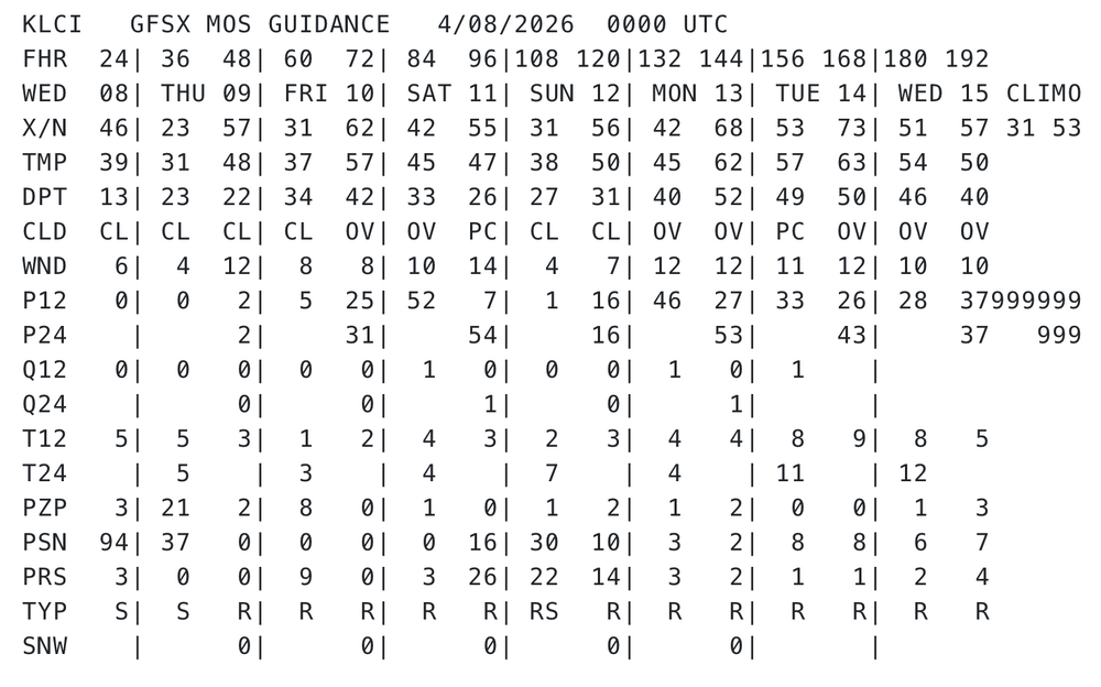
KFIT GFSX MOS GUIDANCE 4/08/2026 0000 UTC WED 08| THU 09| FRI 10| SAT 11| SUN 12| MON 13| TUE 14| CLIMO 33 55 X/N 48| 24 59| 35 66| 44 60| 32 60| 44 70| 55 75| Heh, nothing like being 20 points above climo at both ends of the diurnal range, at 6 days lead time in a MOS product that is pretty heavily weighted toward climatology at that range ... I do think next week is kind of 'first test' for this summer - personally - because I feel this year's season has a shot at some historic heat. The reason primarily being the pan-dimensional dry antecedent continent, with lower persisting soil moisture anomalies, right as we are about to jump into the highest sun angles of the year. Keep in mind, we are less than 1 month from solar max entry... on or about May 6. We just need to shed the 90/60 polar vortex and things can turn around and catch civility off-guard. We still live in a CC-enraged synergistic heat event planetary system and that's not going away... This seems to be a good candidate year to test if we send the mercury into over-achieving warm results, both relative to pattern... but relative to "when it gets hot". Again, we need to get the patterns ...so we'll see. In the meantime, this next Tues/Wed, if that boundary does hull up NW and leaves our region soaked in WSW flow of dry kinetically charged air mass, that's an opportunity to over perform. Being 20 over climo weighting at D6 isn't trivial
-

Central PA Spring 2026 Discussion/Obs Thread
canderson replied to Voyager's topic in Upstate New York/Pennsylvania
26 at home too. The tulips looked sad this morning. -
WU has me at 86 next Tuesday.
-
IAD barely touched 32, and not till *after* sunrise.
-

Central PA Spring 2026 Discussion/Obs Thread
Itstrainingtime replied to Voyager's topic in Upstate New York/Pennsylvania
Frosty low of 26 this morning. Looks like you'll be enjoying a lot of relatively dry weather here at home while I deal with the onset of the rainy season in the Caribbean. -
(002).thumb.png.6e3d9d46bca5fe41aab7a74871dd8af8.png)
Central PA Spring 2026 Discussion/Obs Thread
ChescoWx replied to Voyager's topic in Upstate New York/Pennsylvania
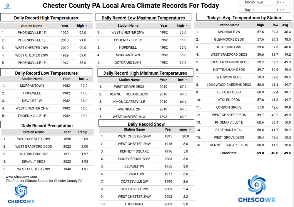
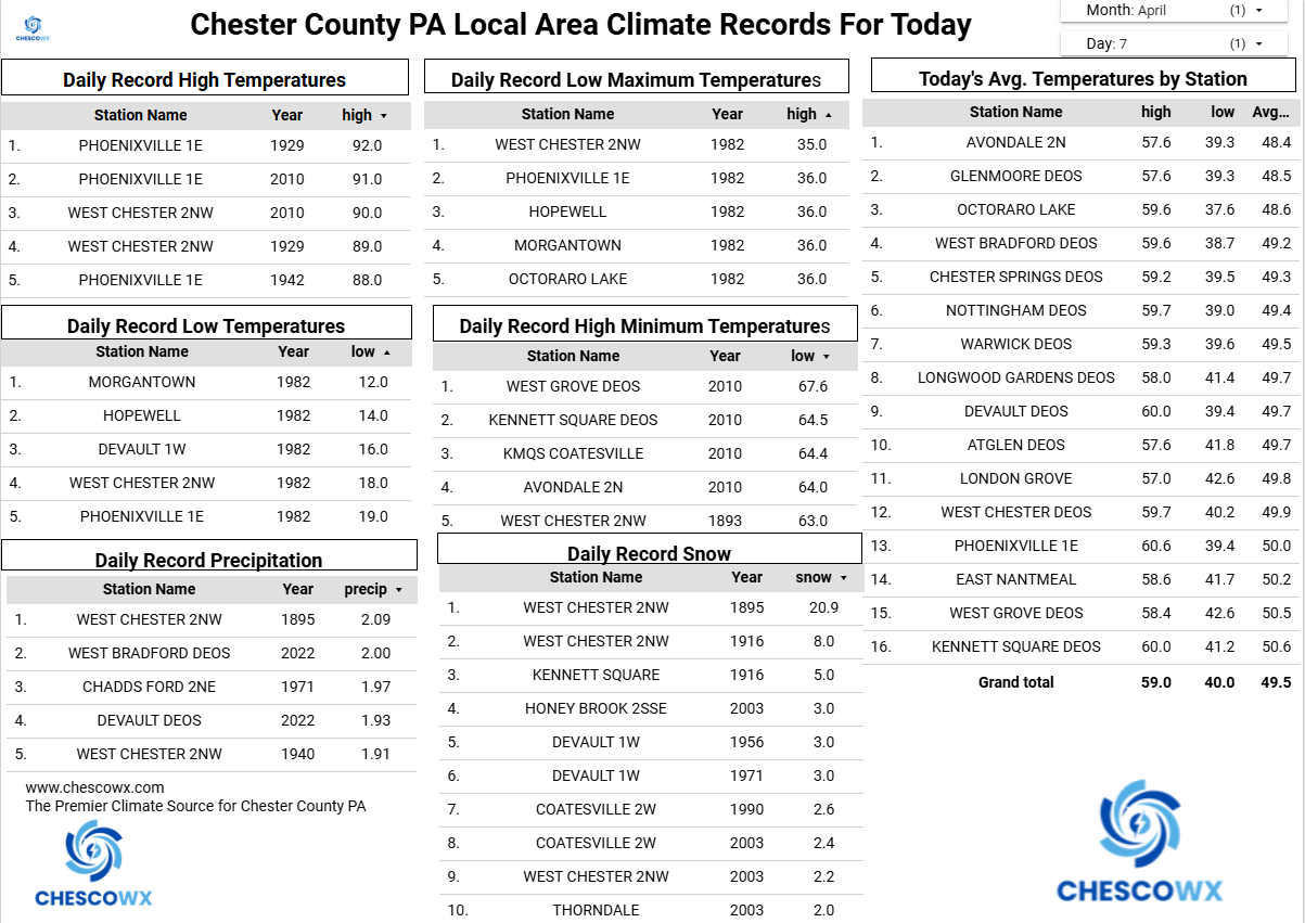
East Nantmeal broke it’s record low this morning with a low of 25.9. The old record was 27.8 set back in 2007. While a short-term record here since 2004 nowhere close to record across the county. The lowest reading I could find this morning was the 21.6 at our typical cold spot in Warwick Township. Another well below normal temperature day with highs struggling into to the low 50’s. Another freeze potential tonight before we start a slow warming trend to near normal temperatures by the weekend with highs in the low 60’s. We should see well above normal temperatures early next week before another cool down sets in by the end of next week. No real rain chances through the week.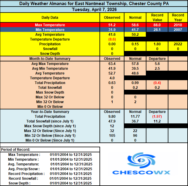
-
E PA/NJ/DE Spring 2026 Obs/Discussion
ChescoWx replied to PhiEaglesfan712's topic in Philadelphia Region
East Nantmeal broke it’s record low this morning with a low of 25.9. The old record was 27.8 set back in 2007. While a short-term record here since 2004 nowhere close to record across the county. The lowest reading I could find this morning was the 21.6 at our typical cold spot in Warwick Township. Another well below normal temperature day with highs struggling into to the low 50’s. Another freeze potential tonight before we start a slow warming trend to near normal temperatures by the weekend with highs in the low 60’s. We should see well above normal temperatures early next week before another cool down sets in by the end of next week. No real rain chances through the week.
-
Cool. 25F in CAR and 80 in BOS
-
Minus the turning the grass blades white if you overspray
-

Central PA Spring 2026 Discussion/Obs Thread
Voyager replied to Voyager's topic in Upstate New York/Pennsylvania
If you're going to use my likeness in your posts, then I demand royalties... -
The targeted for misery factor might be even more delicious the next day on Wednesday...
-
25 for the low here. Heat was running this am
-
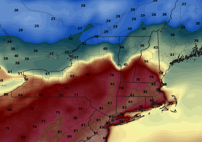
Brian's rage would know no bounds should this be the status at 21z this next Tuesday afternoon. Or PF! haha. Nothing like an 82, Metrowest of Boston, while it's a warm cloth to the balls 38 in N VT

-
Cold at 20.3 this morning. Might be a while before that's seen again. Please don't be gone too long.
-
Tenacity is great stuff.....I don't use the weed stuff anymore, either....tenacity takes care of it.
-
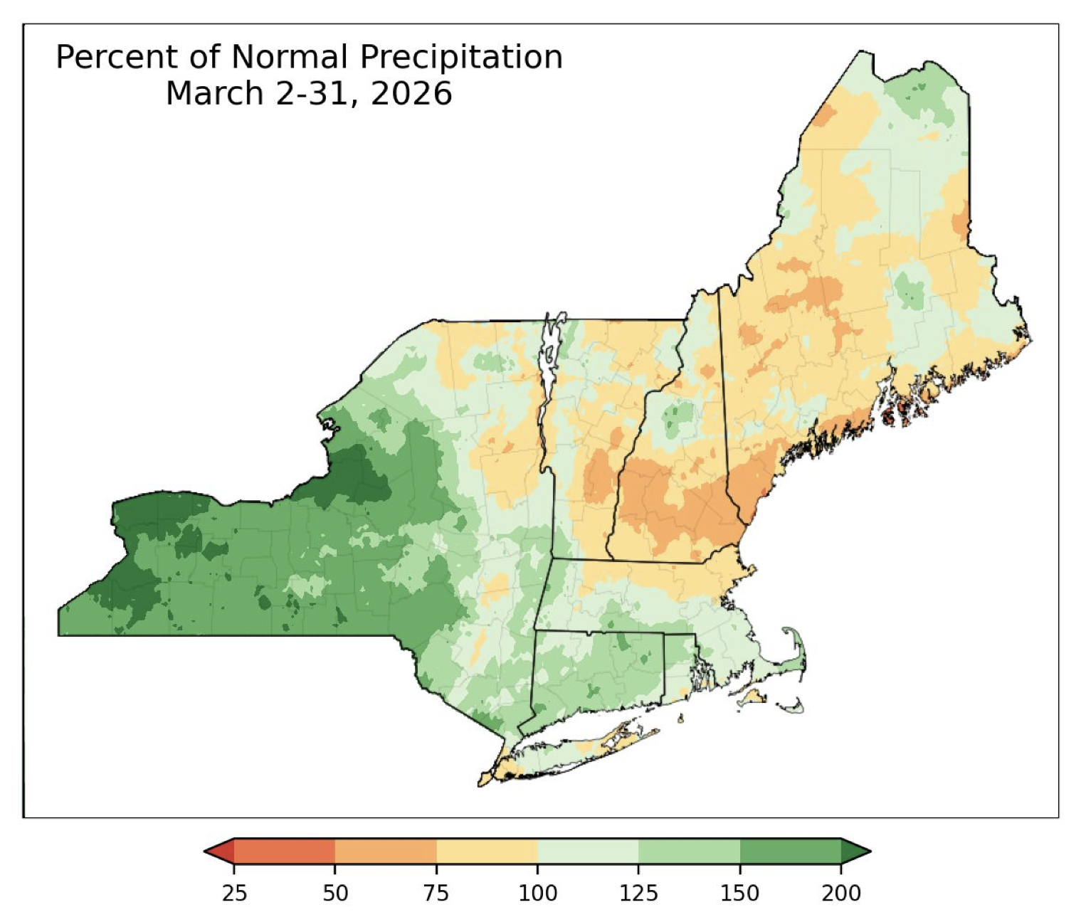
March was really dry despite a couple of minor snow events

-
Aren’t you buried in snow ?
-

2026-2027 El Nino
snowman19 replied to Stormchaserchuck1's topic in Weather Forecasting and Discussion
@Bluewave -
Bottomed out at 21, the average low for this date is 34.


.thumb.JPG.418e8a9a2902ae687ec35ff4bc0e038e.JPG)