All Activity
- Past hour
-
The Bears give up over 5 yds per carry. Patrick Ricard is back. If Monken fucks this game plan up, tries to get cute with tush pushes and whatever other dumb shit he does, he should be fired immediately. Run the damn ball. Control the clock. Score enough and keep the defense fresh. No brainer.
-
-
Harbaugh lol. He was exposed this morning by Rapoport. Lamar ran the scout team yesterday.
-
.thumb.png.4150b06c63a21f61052e47a612bf1818.png)
Spooky Season (October Disco Thread)
HIPPYVALLEY replied to Prismshine Productions's topic in New England
Correct -
both HAFS-A and HAFS-B (12Z) models showing a direct hit to Kingston with around 940mb, yikes
-
Less than an hour after the announcement that Jackson is out Sunday, the Ravens went from being a 6.5-point favorite over the Bears to a 1.5-point favorite, according to ESPN BET. https://www.espn.com/nfl/story/_/id/46720713/ravens-qb-lamar-jackson-hamstring-miss-3rd-straight
-

Spooky Season (October Disco Thread)
Torch Tiger replied to Prismshine Productions's topic in New England
Yeah looks cuttery -
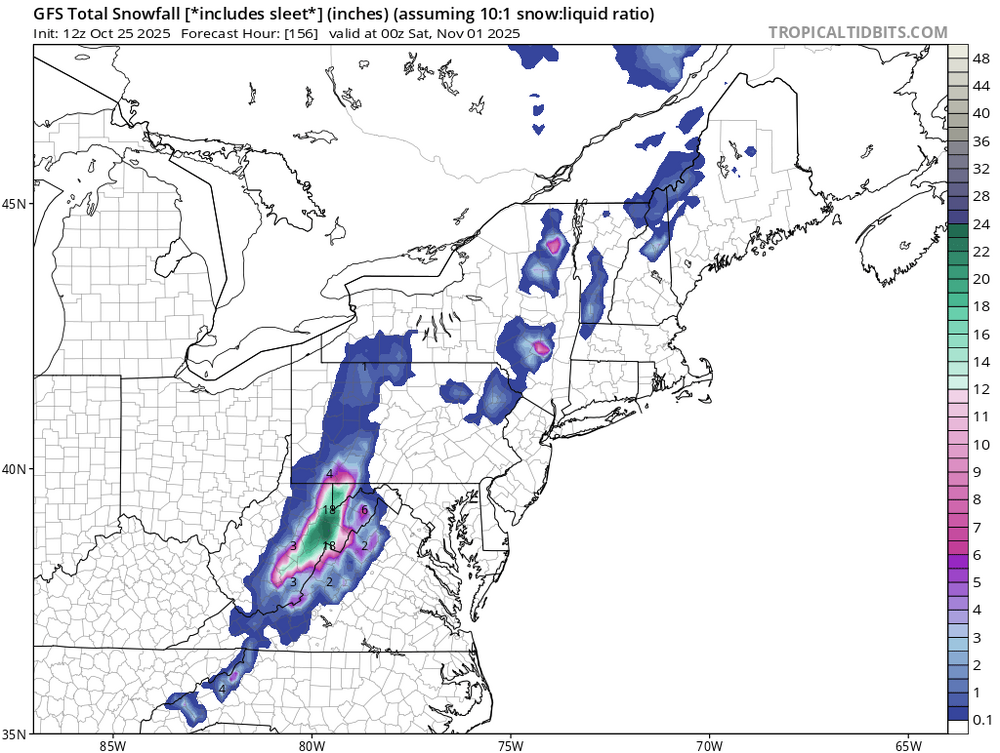
GFS actually has snowfall all the way into Shenandoah this Friday. Personally I just hope WV gets something and it sticks around till Friday midday when my tests are over for the week.
-
Oops https://www.nbcsports.com/nfl/profootballtalk/rumor-mill/news/ravens-rule-out-lamar-jackson-admit-he-was-not-a-full-participant-in-fridays-practice
-
Unfortunately I don’t think I’ll be able to get my hands on it. Though next semester when I’m in lab for the class I’ll have access to it and will use it to create a scew T diagram!
-

Central PA Fall Discussions and Obs
Superstorm replied to ChescoWx's topic in Upstate New York/Pennsylvania
Mellissa is exploding right now. . -
Organization before intensification
-
Huntley gets the start tomorrow. Lamar ruled out. Seems they don't want to put him back in there Sunday with a game on Thursday night. That's the target now. Ofc if they lose tomorrow, might as well give him a couple more weeks to get fully healthy.
-
32 this morning, first freeze
-
IAD is actually like Oct 20? BWI around Nov 1 and DCA in mid January.
-
Good fall weather for sure. .
-
36.9 low but was 46 at 6:50 when I got up. .
-

Spooky Season (October Disco Thread)
Damage In Tolland replied to Prismshine Productions's topic in New England
EPS last night had it cutting way west of us too -
Normal freeze date for IAD isn't until November, IIRC.
-

Spooky Season (October Disco Thread)
OrangeCTWX replied to Prismshine Productions's topic in New England
Chill CMC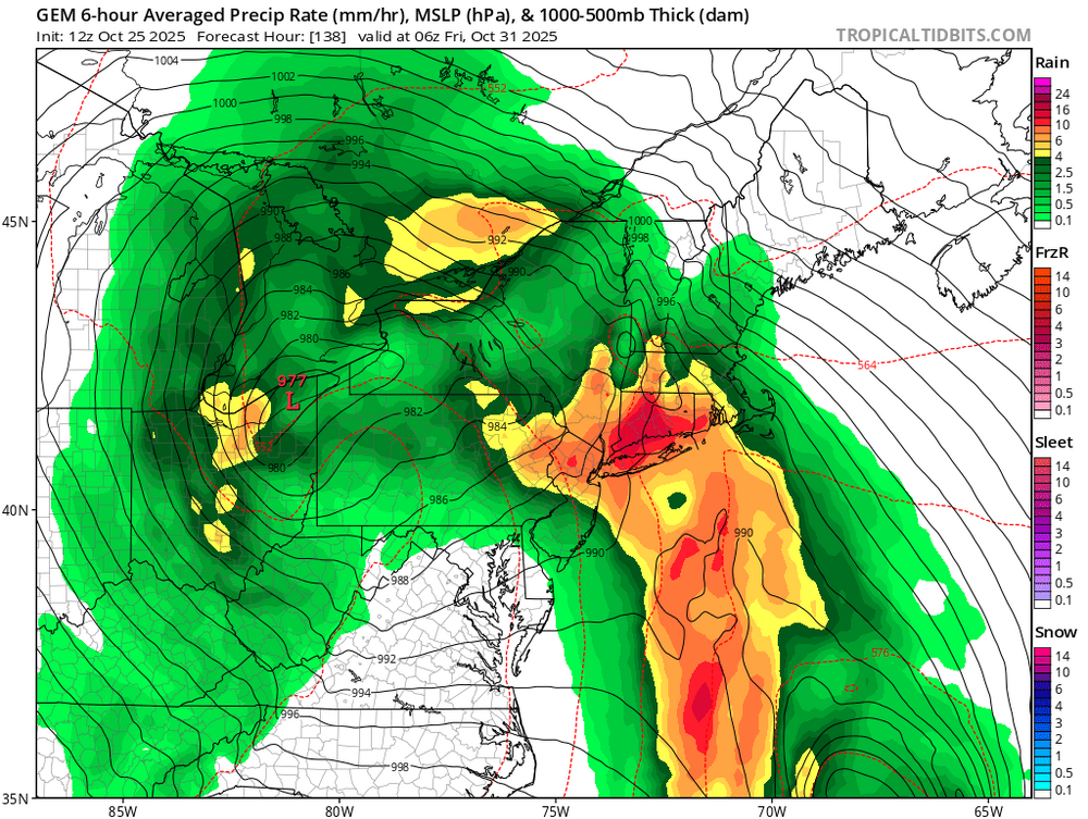
-
Nice! Got sounding data to post?
-
The Canadian is the only model with hurricane so far west. The Euro and GFS are further east. So a nice compromise would be a deepening low going to our west opening a moisture channel with the hurricane staying offshore like a PRE or IVT to enhance the rainfall potential.
-

Spooky Season (October Disco Thread)
Snowcrazed71 replied to Prismshine Productions's topic in New England
Kind of a hybrid I guess... Does start out in the ocean and cuts in near the Delmarva. At least on this depiction. To me when I think of an inland cutter, it starts out in the Great lakes and lives its way up through the St. Lawrence valley or the Appalachians. But potato-pototo I guess -
UKMET has been even worse with a number of runs early on hitting Nicaragua and with it then correcting NE but only slowly. This issue was likely mainly due to it having it too weak. It is such a hot or miss model as it was stellar/the best with Imelda as well with Ian among others.
-
that hurricane doesn't have to get very close to the coast to be able to combine forces with the trough and inland storm along it to create another situation along the coast similar to what happened a couple weeks ago which would be devastating in areas prone to flooding and beaches eroded even further..........


