All Activity
- Past hour
-
Popcorn https://weather.cod.edu/satrad/?parms=local-Virginia-02-24-1-100-1&checked=map&colorbar=undefined Sun and clouds and 67 at 3pm. Very nice.
-

2025-2026 ENSO
donsutherland1 replied to 40/70 Benchmark's topic in Weather Forecasting and Discussion
I agree. I suspect that's part of the reason we saw a very warm end to September across much of the CONUS. -
Won't be able to put anything of great depth or detail together for the winter, but my thinking right now is that it is going to be a above average temperature regime for much of the country and could be on the drier side, except maybe the West and we'll see an overall theme of de-amplifying systems trucking across the country with another raging jet the culprit.
-
The new CANSIPS is showing more of an Aleutian ridge regime than an Alaskan ridge regime this winter
-
Occasional Thoughts on Climate Change
donsutherland1 replied to donsutherland1's topic in Climate Change
IMO, until global shocks become truly synchronized, the prevailing inertia is likely to persist. Psychologically, shifting from decision avoidance to proactive problem-solving is extraordinarily difficult for leaders who lack courage and foresight, especially when doing so requires sacrificing the comforts of the status quo. The danger, as the literature suggests, is that by the time globally synchronized harvest failures and cascading disasters emerge, warming will already have advanced to levels where damage is locked in and far worse than it might otherwise have been. Some studies project once-per-decade synchronized shocks around 2 °C of warming. Yet even at that scale, such events could still be dismissed as “bad luck,” painful in human and economic terms but ultimately normalized within existing systems of risk. Only when these shocks become unmistakably regular, perhaps near 3 °C warming, will denial and delay collapse under the weight of recurring crises. Human societies have always normalized risk until it is unavoidable (Typhoon Tip's linkage to human nature is on the mark), and climate change has been no exception. People tend to discount future dangers, cling to established routines, and resist costly change until shocks become both visible, substantial, and persistent. Until synchronized failures shift from rare to recurrent, most governments and industries are likely to stick with the status quo, effectively sustaining the global geoengineering project of filling the atmosphere with carbon. In doing so, they are constructing a future marked by predictable and frequent catastrophes. When that moment arrives, excuses will abound, but the truth will remain: these crises were foreseeable and foreseen. Even more importantly, they were preventable. Today, humanity possesses both the knowledge and the means to act. Yet, it chooses not to do so, ensuring its investment in inaction will yield tomorrow's challenges and catastrophes. -
Just adding to this. I think our window for something purely tropical is closed. With each passing day in October climo makes it so. But given the troughing we’ve seen and the possibility for a CAG ejecting something or stalled front induced coastal low off the SE coast later in the month some sort of hybrid wouldn’t be a pipe dream. We’ve actually done very well in recent years getting at least one October coastal with a little tropical influence.
-

Spooky Season (October Disco Thread)
Spanks45 replied to Prismshine Productions's topic in New England
yeah, unique little sandy valley....you could feel it as soon as the sun went down that it was going to radiate perfectly....clear and calm again tonight should yield another round of mid 30s by sunrise, that and no return flow starting until after daybreak -
We're really good at that.
-
33 mph gust in Gulfport, FL a few minutes ago. That's more than Imelda brought which was a very nice steady breeze. I looked at NOAA and was surprised to see a lemon!
-
Notable exception last year with the white christmas and absurd freezing cold a few days beforehand.
-
"September was fallish". I see you chose to ignore the entire second half of the month. Summer teetered out early and then came back with a vengeance after mid Sept. Hell, the upper midwest is getting its hottest temps of the entire season right now in early October.
- Today
-

2025-2026 ENSO
PhiEaglesfan712 replied to 40/70 Benchmark's topic in Weather Forecasting and Discussion
Once the average seasonal snowfall drops below 4 inches (about the current average in Charlotte) in places like Baltimore and DC, then I know we've reached the point of no return. At that point, snowy winters might be a thing of the past. It might not happen with the 2001-30 averages, but it's certainly possible in the 2011-40 averages. -
Crap ninos tend to be a bit better than crap ninas cause at least you can shoot up a big L up the coast and cross your fingers it happens to align with a cold shot. That basically just doesn't happen in ninas.
-
What makes you say a ridge in the goa will be a prominent feature?
-

Occasional Thoughts on Climate Change
gallopinggertie replied to donsutherland1's topic in Climate Change
Yes, and unfortunately the mechanism of greenhouse gases isn’t something that alarms most people in the same way that acid rain or ozone depletion does. It seems like to get people to care about a threat that’s larger than them, it usually has to connect with them on an instinctive, gut level. So there’s that, even aside from our difficulty with this kind of long-term thinking, that makes the problem so hard to address as a group. -

2025-2026 ENSO
brooklynwx99 replied to 40/70 Benchmark's topic in Weather Forecasting and Discussion
yeah, not the best job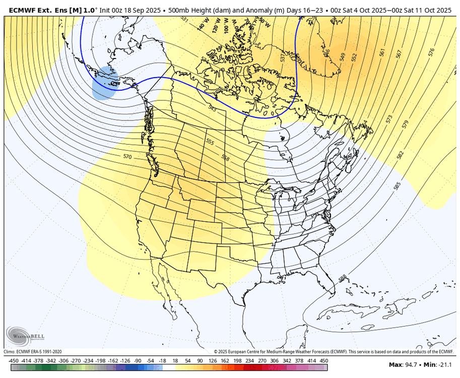
-

Spooky Season (October Disco Thread)
mreaves replied to Prismshine Productions's topic in New England
I keep thinking about they saying you've shared in the past about winter not starting until the swamps are filled. If that's the case, winter is a looong way off up here. -

-

Spooky Season (October Disco Thread)
tamarack replied to Prismshine Productions's topic in New England
Our average water year is 48.89". This recently ended one had 38.08", only 78% of the average. 2025 thru September is 7.13" BN and last October was 3.56" BN, giving the water year a dry start. -
2015-16 was an above to much above average temp winter here and snow wise was above normal. You have to remember as you go south you need less snow overall to get to normal and one epic pattern or good luck can get you there. I don’t take much stock in temp maps that show above normal and think that means it’ll automatically mean it’s another bad snow winter. If I see another setup for more stretches of a horrendously bad Pacific that means much more to me.
-
EPS weeklies try to bring the GOA trough back by the 20th of this month. But on the other hand they didn't see this GOA ridge until a few days ago. But considering this GOA ridge will probably be a dominant feature this winter I am not surprised to see it poking back up.
-

Spooky Season (October Disco Thread)
Prismshine Productions replied to Prismshine Productions's topic in New England
If lucky that Sent from my SM-S166V using Tapatalk -
That was when one of the worst ice storms for northeast OK occurred. Please no
-
We're barely going to be in a La Nina, if we even officially get there. ENSO will probably have little influence on the overall regime.
-