All Activity
- Past hour
-

2026-2027 Record-breaking El Nino
Lucy Pull replied to Stormchaserchuck1's topic in Weather Forecasting and Discussion
I’m not against seeing +10 or more anomalies in the northern CONUS. I think this is quite probable. Im just not ready to say we rip +10 on the entire east coast. Especially towards the southeast like 2016. If we get an eastern ridge linking up with the Canadian ridge all bets off. -

2026-2027 Record-breaking El Nino
forkyfork replied to Stormchaserchuck1's topic in Weather Forecasting and Discussion
post about dec 2015 and the hive closes in -

2026-2027 Record-breaking El Nino
mitchnick replied to Stormchaserchuck1's topic in Weather Forecasting and Discussion
-

2026-2027 Fall/Winter Mountain Thread
nrgjeff replied to BlueRidgeFolklore's topic in Southeastern States
Should be good at 1,000 to 1,500 FT this weekend. We wasted two perfect weekends for higher elevations, totally sunny. Too many activities with two kids. We're hoping for some local spots that are less crowded; but of course, rain is forecast this weekend! -
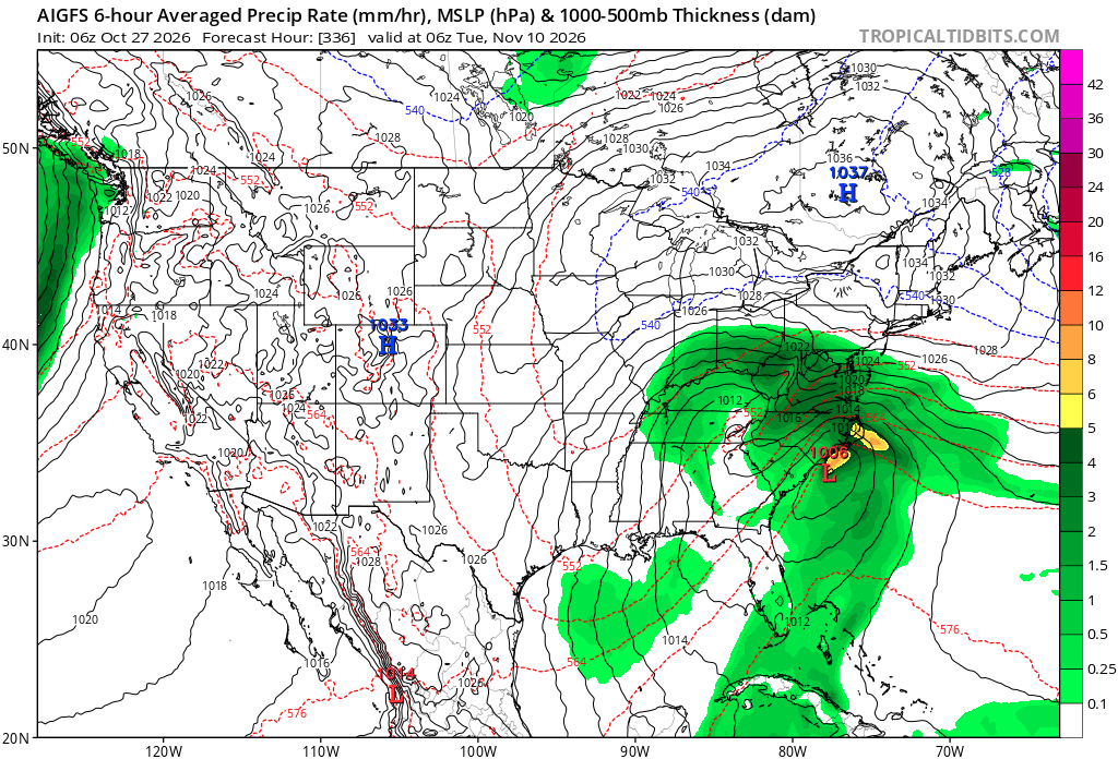
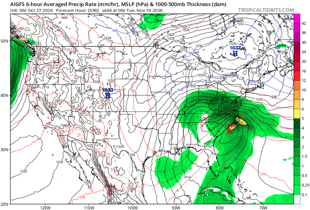
Seeing a lot of tracks like this showing up on the medium-long range models.
-
Everyone remembers 6/95...besides 8/10/00 the most lightning in sne
-
Records: Highs: EWR: 81 (1963) NYC: 82 (1963) LGA: 79 (1963) JFK: 78 (1963) Lows: EWR: 27 (1936) NYC: 28 (1936) LGA: 33 (1976) JFK: 31 (1976) Historical: 1764 - A "very remarkable storm of snow with high winds" produced 22 inches at Rutland in central Massachusetts. (David Ludlum) 1929 - A snowstorm dumped 27 inches upon Ishpeming, MI, in 24 hours to establish a state record. (David Ludlum) 1943: Coastal storm ends drought, rains on 25th - 28th DC had 3.41 inches of rain and Baltimore got 5.00 inches. (Ref. Wilson Wx. History) 1962 - An early season winter storm over New England blanketed northern Maine with 7 to 16 inches of snow, and southeastern New England with up to 3 inches of snow. Worcester MA received a record 4.7 inches of snow. (The Weather Channel) The low temperature of 21 °F is the lowest temperature ever recorded in Richmond in October. (Ref. Richmond Weather Records) 1987 - Showers and thunderstorms produced locally heavy rain from Virginia to New York State. Fallen leaves made roads and sidewalks slick, and also clogged sewers. Rainfall totals of 1.55 inches at Newark NJ, 1.54 inches at Harrisburg PA, 1.27 inches at Scranton PA, and 1.22 inches at Atlantic City NJ, were records for the date. (The National Weather Summary) 1988 - Low pressure brought snow and gale force winds to the Great Lakes Region, and snow and high winds to the north central U.S. Winds gusted to 47 mph at Lansing MI, and reached 55 mph at Pierre SD. (The National Weather Summary) (Storm Data) 1989 - Wintry weather invaded the northwestern U.S. A storm crossing the Central Rockies produced up to 23 inches of snow in the mountains east of Salt Lake City UT. "Indian Summer" continued in the Lower Ohio Valley and the Upper Great Lakes Region. Afternoon highs of 71 degrees at Marquette MI and 72 degrees at Sault Ste Marie MI were records for the date. (The National Weather Summary) (Storm Data) 1996: Thousands of homes in southern and central Texas were without power after strong storms dumped as much as a foot of rain. The Frio, Guadalupe, and Llano rivers spilled their banks, making roads impassable and stranding some motorists. The Llano crested at 30 feet -- 18 feet above flood stage -- and Llano County sheriff's deputies were evacuating homes downriver. (Ref. AccWeather Weather History) 2003: A strong cold front moved through the Mid-Atlantic during the afternoon, causing an outbreak of severe weather. An F0 tornado touched down in Hainesport, NJ, killing one person. This was the first tornado fatality in Burlington County, NJ history both in modern tornado records kept since 1950, and in reliable unofficial records extending back into the 1700s. The tornado cut a path 1/2 mile long and 30 yards wide. Although the tornado was F0, it is considered a significant tornado, usually F2 or greater, because of the fatality. (Ref. Wilson Wx. History) 2006: An F1 tornado (waterspout) came ashore and caused significant damage on the west side of Apalachicola Florida. 2006: An F1 tornado (waterspout) came ashore and caused significant damage on the west side of Apalachicola Florida. Marine boats sank, four homes destroyed, and part of a hospital roof collapsed. Hundreds of trees and power lines were down, but fortunately there were no serious injuries. (Weather Guide Calendar with Phenomenal Weather Events 2007 Accord Publishing, USA)
-
 We all know winter is going to be a blowtorch, no need to post anomaly maps Captain Obvious. Although you do need to open your viewpoint to see the entire board instead of just temps: We have descending solar + geomag interference A warm pool east of Japan and PDO that is being more stubborn than 4th Quarter/OT Dan Quinn playcalling A record warm Pacific in the ENSO regions but still have a nagging ENSO-cool background state that is persistent. A Polar Vortex that is going to be under repeated strain. And the ENSO is supposed to drop over the course of winter as we head towards another La Nina. However: the Pacific Firehose also means that we have AN precip on the East Coast that will help offset the AN temps. Lower snow ratios sure, but still snow chances from Nor'easters. The average temp for interior New England for example of around 25 in deep winter can survive a +7 easily and still get accumulation. Point is: record warm yes, but when you factor in everything else (QBO, AO, NAO, PNA, etc) in this specific combo? We all got to wait and see just how extreme it will be since computer models can both be too warm or too cool Sent from my SM-S176V using Tapatalk
-
2026-2027 Record-breaking El Nino
forkyfork replied to Stormchaserchuck1's topic in Weather Forecasting and Discussion
15 +10 months somewhere in the country in the past decade and somehow dec 2015 is too extreme to consider -

2026-2027 Record-breaking El Nino
GaWx replied to Stormchaserchuck1's topic in Weather Forecasting and Discussion
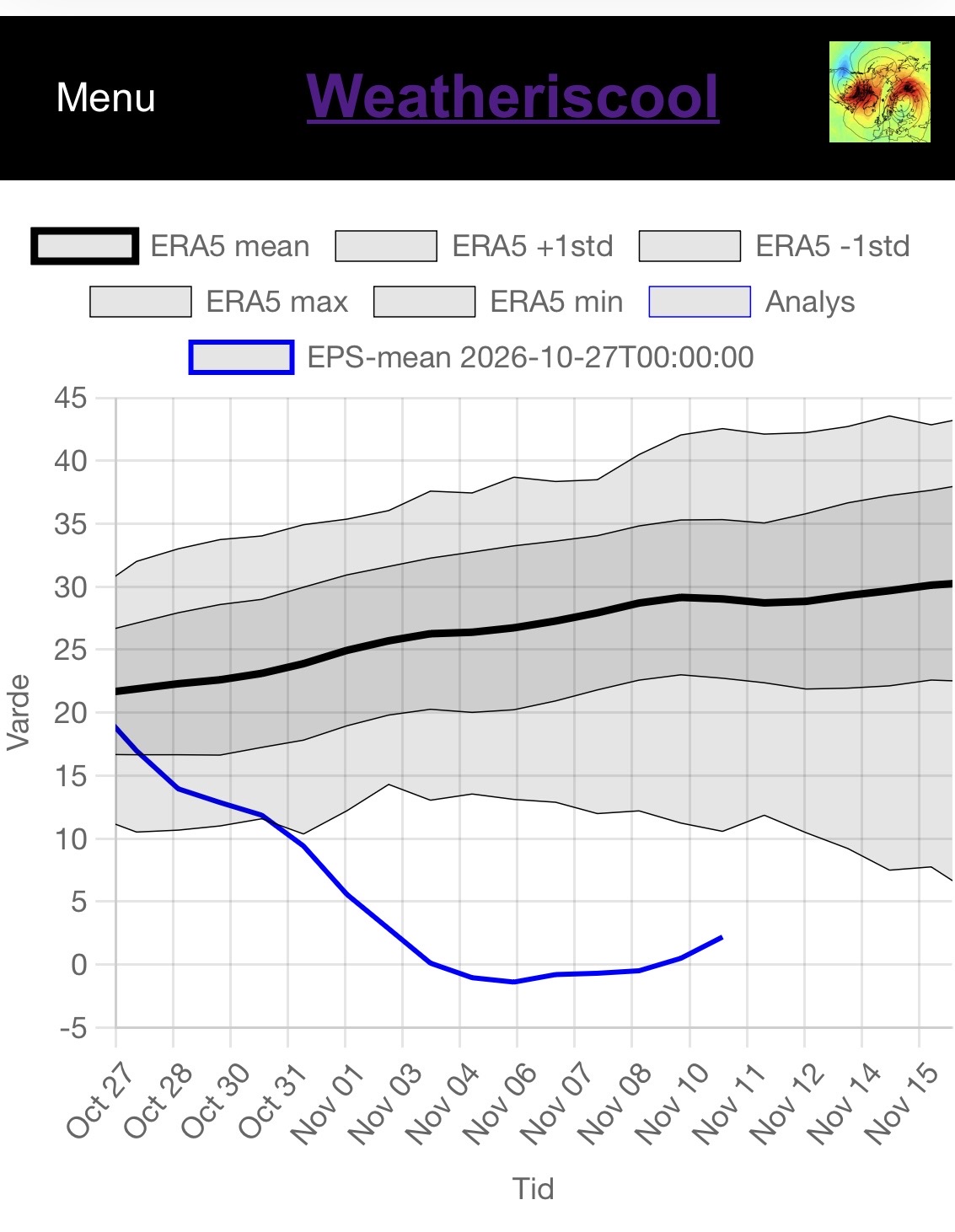
For those who don’t realize how unprecedented in the ERA5 records this is forecasted to be at 10mb, 60N: The 0Z 10/27/26 EPS mean is forecasted to be 10-14 below the weakest on record (I don’t know how far back though) and 24-29 below the mean per ERA5 data Nov 3rd-10th!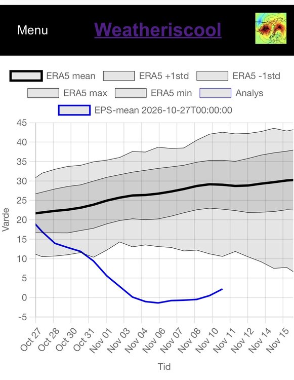
-
58 / 40 and the great stretch continues for late October. A touch cooler today and Wednesday then Thu - Sat should send most back to the 70s and temperatures will peak Friday with mid perhaps upper 70s. Overall warm 11/1 and beyond and dry through the 2nd with the next chance of meaningful rain towards the 2nd as weep trough into center of the nation.
-
This Halloween will be a stark contrast to the 2019 one. Had several inches of snow and temps in the 20s.
-

2026-2027 Record-breaking El Nino
JVscotch replied to Stormchaserchuck1's topic in Weather Forecasting and Discussion
I hear you. I believe it’s more than just that. We are still in late October and I feel need to see how things develop in November and heading towards December. I know the strat stuff has mixed reviews on impacts but I still feel more comfortable seeing it taking strong hits than not. This El Niño is a beast and east-based, but the warmth in 3 and 3.4 is stronger than 1997 as well which can hopefully allow further westward movement of the North Pacific low a couple times if it also feels extreme blocking over the arctic. I think as a whole, it’ll be hard to fight the El Niño’s tendency to overwhelm but not impossible with other forcing from MJO and the arctic. Others have stated this kind of stuff already so nothing new, but I do feel is important. Being in MD, I’m just hoping for a good storm or two as we are long overdue for a big dog. -
 best online medicine store and medication from india best medicine website http://www.automaniabrandon.com/LinkOut/?goto=http://zenithindusrx.shop/ get medicine instantly or http://ussher.org.uk/user/cjczglsngv/?um_action=edit medicine online delivery [url=https://www.google.cd/url?sa=t&url=https://zenithindusrx.shop]order medicine without prescription[/url] medicine from india or [url=https://www.trendyxxx.com/user/itsapsdbue/videos]indian pharmacy prednisone[/url] pharmacy websites
-
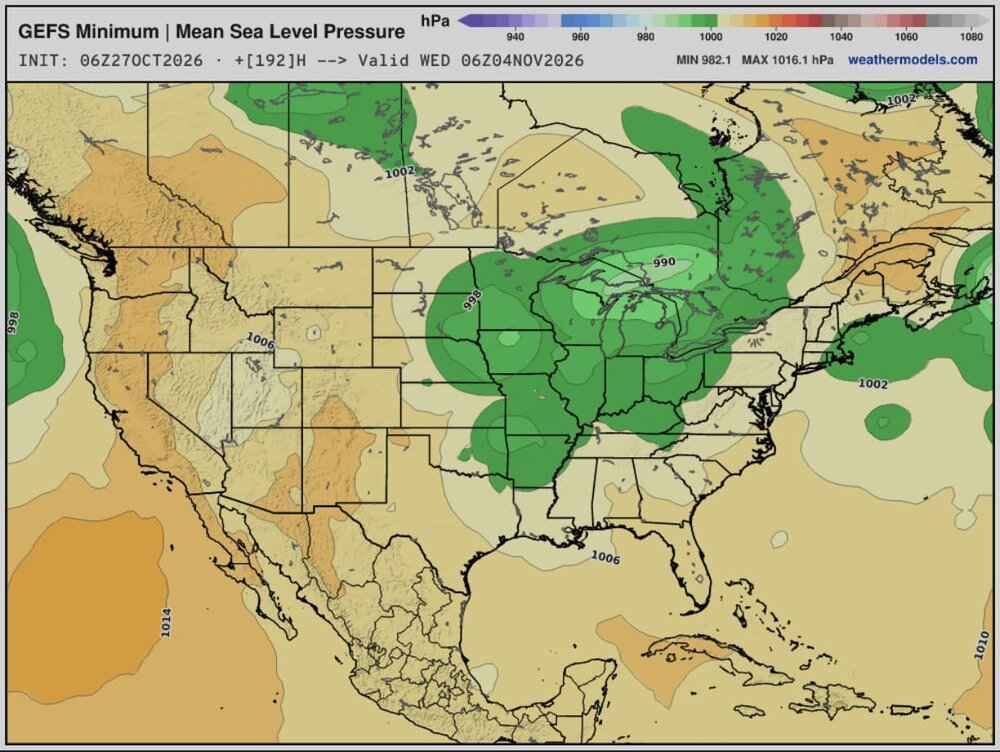
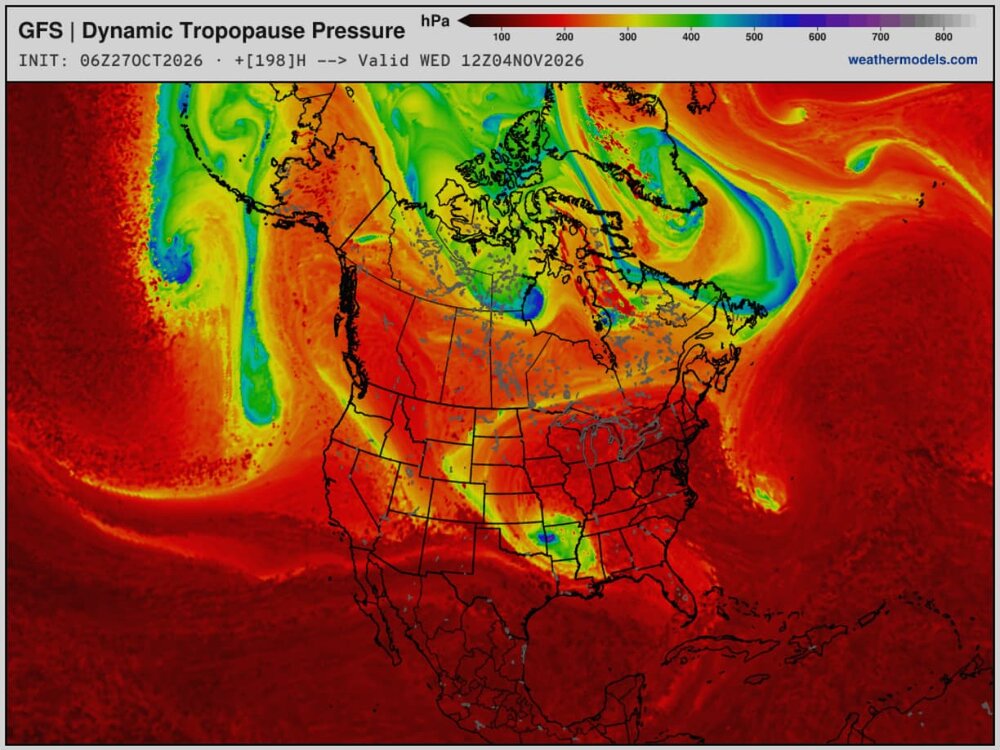
Thinking that there could be an interesting/more active pattern change coming mid-next week, with a much more seasonable airmass sticking around after like weds/thurs. Chances for rain showers, too
-
September is the sunniest month. I too have been enjoying this stretch. We'll have our share of storms and wind this winter
-

2026-2027 Record-breaking El Nino
40/70 Benchmark replied to Stormchaserchuck1's topic in Weather Forecasting and Discussion
There is also no antecedent airmass to work with this early in the season. -
2026-2027 Record-breaking El Nino
40/70 Benchmark replied to Stormchaserchuck1's topic in Weather Forecasting and Discussion
Yes, all we can say is that this El Nino will be a bit warmer than it would have under identical conditions a decade ago....but not sure that is enough to account for the lack of MC contribution. We spent a decade observing how that amplifies warmth over the eastern CONUS, so we can't now pretend that it wasn't a factor. -
2026-2027 Record-breaking El Nino
forkyfork replied to Stormchaserchuck1's topic in Weather Forecasting and Discussion
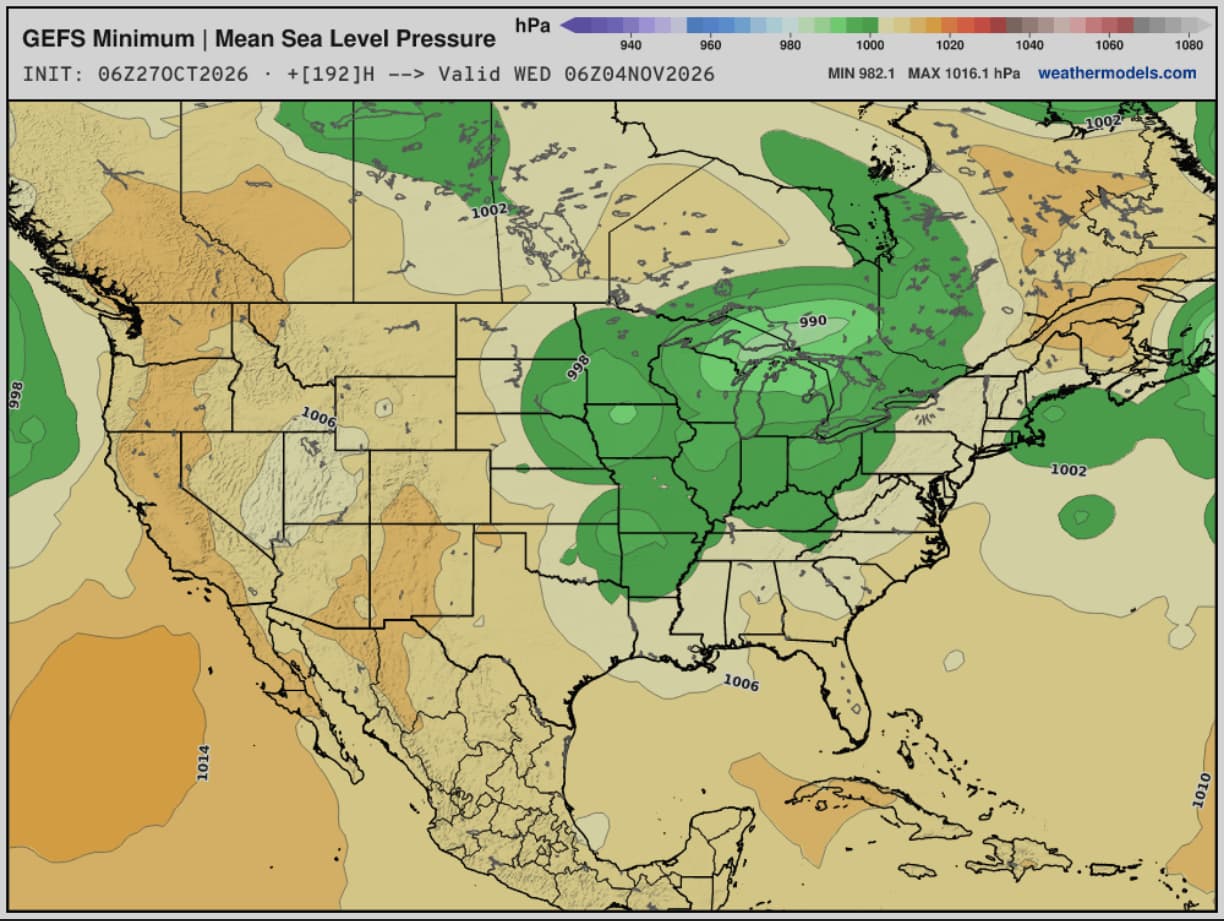
all you need is a trough in the west and this happens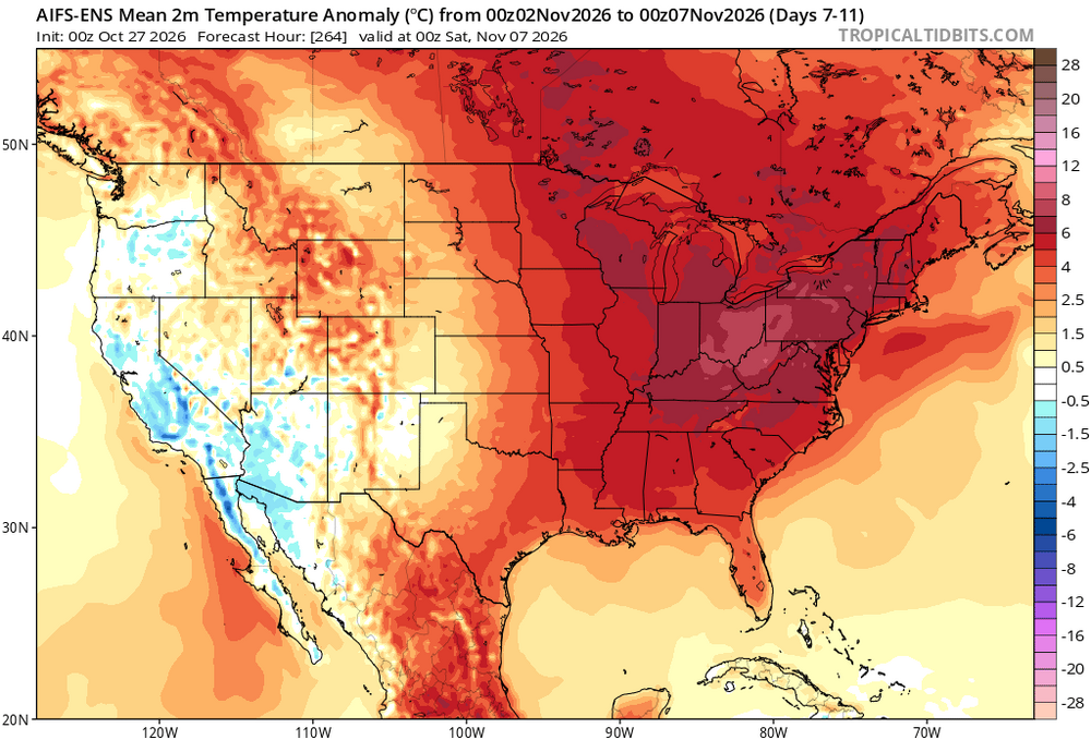
-
Isn’t it supposed to be calm this time of year? Doesn’t October have the most sunny days on average? Or am I thinking of another month? The action will come…it always does. And to be honest…I’m digging the clear beautiful weather at the moment. We’ve had enough rain all summer and fall up to two weeks ago.
-
2026-2027 Record-breaking El Nino
JVscotch replied to Stormchaserchuck1's topic in Weather Forecasting and Discussion
I thought the MJO was the biggest factor, as MJO went through phases 4-6 in December which amplified the warmth. The MJO has heavily been absent from these phases since summer. If somehow we manage to hit them, then sure. -
2026-2027 Record-breaking El Nino
forkyfork replied to Stormchaserchuck1's topic in Weather Forecasting and Discussion
and this nino is a steroid injection -
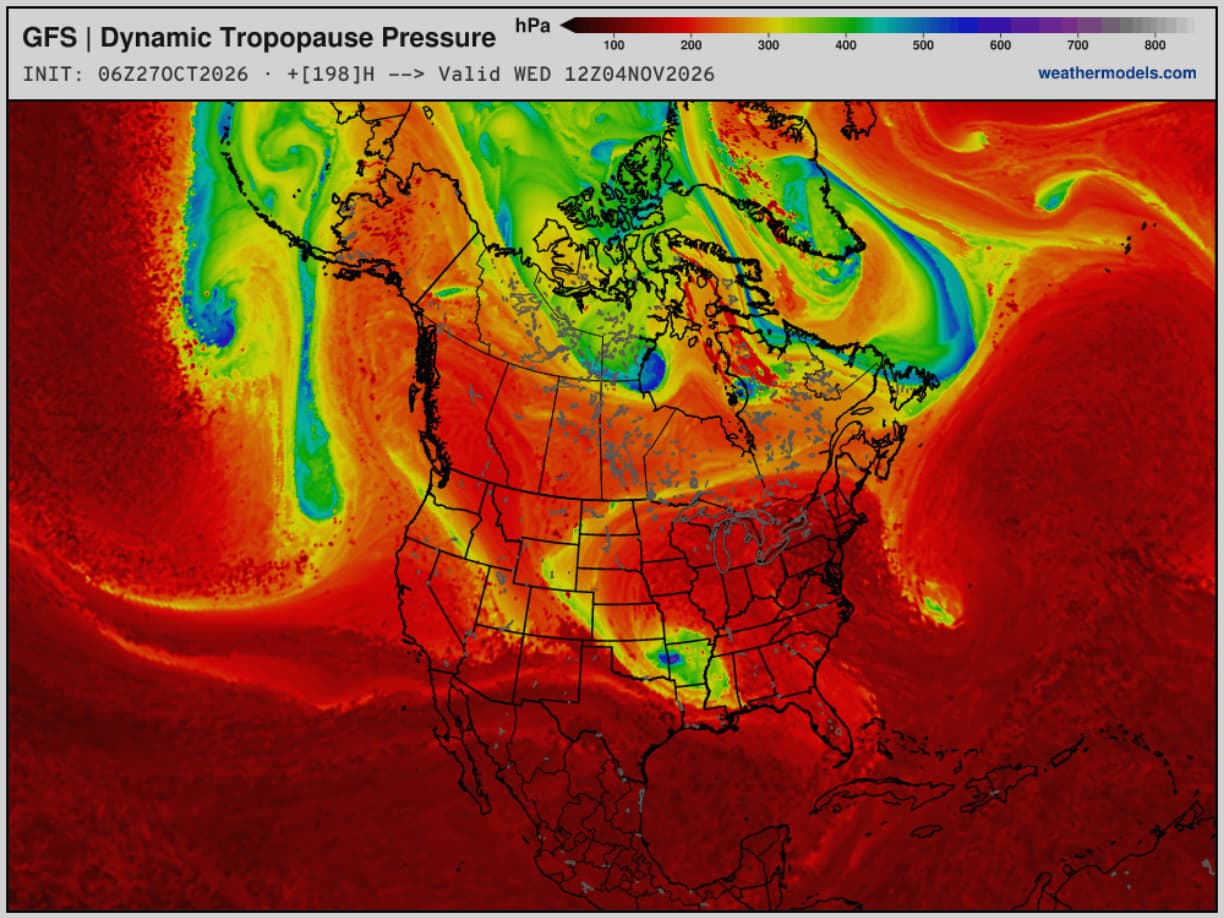
Andrej / severe-weather.eu @Recretos · 10m https://x.com/Recretos/status/2115073153533653480 With a lot of talk about the upcoming Polar Vortex disruption and a potentially official SSW (Stratospheric Warming) event, most people cant see what makes this event "unprecedented" as its often called. And for a good reason, as a single map of the #polarvortex can be vague in context. I decided to visualize that context. The official criteria for an SSW event is the reversal (0 or negative value) of the stratospheric winds at the 10mb level along the 60N polar circle line. We are still on the edge if we will reach a reversal with this event, but there are forecast runs that suggest its likely. Link to those live forecasts is in the comments Most of the SSW events occur in January and February. I decided to look at every first SSW of each season (some seasons had two) and when it occurred. As you can see, a reversal in the current event would break the record for the earliest SSW on date by at least 3 weeks! This is really a strong outlier, and having an SSW this early in the season is what makes this event unprecedented in itself, perhaps more so than any temperature or pressure anomaly in the stratosphere. Its likely not a coincidence we get this with a very strong Super El Niño ongoing in the Pacific. So overall, this is truly a very interesting season for anyone that is into monitoring the weather and seasonal development.
-
BAM Weather @bam_weather A #polarvortex split at this point is likely not if but when. This will have significant implications to the 2nd half of NOV and likely introduce much colder risks to the outlook. We will have a full detailed breakdown out to BAM clients today with our updated 3-4 week outlook. Excellent plots @Recretos thank you.
-
2026-2027 Record-breaking El Nino
forkyfork replied to Stormchaserchuck1's topic in Weather Forecasting and Discussion
how is dec 2015 so unreasonable if the climate has warmed since then and this nino is stronger?