All Activity
- Past hour
-

Boxing Night Snow/Sleet/Ice Dec 26-27 Storm Thread/Obs.
Albedoman replied to Mikeymac5306's topic in Philadelphia Region
Winter is going to take a brief break after this BS first of the year storm of only 1-3 inches if we are really lucky. I see no snowstorms until after the 15th and it will warm up into the upper 40's to 50's . I do think we will pay the piper for this brief warm up by Marin Luther Kings day-- seems to be the pattern the last 5 years. All I can say is the drought situation in our area is only going to worsen as the Gulf storm production is shut down for business. Believe me, dried up wells and sinkhole formation with dropping groundwater tables with waterline breaks galore will be the talk of the town in the next three weeks as the ground starts to thaw out with what little moisture is in it. The base flows of the creeks will begin to drop again too. We really need a 96 type of storm event asap. -
6” miller place. A little disappointed but I’m being greedy. If I can get to 7” that will give me 15” for December. I’ll take it!
-
ISP reporting 5"
-

Wounded Duck Strikes Back: Dec 26 & 27th Winter Storm Obs
Amped replied to WxWatcher007's topic in New England
Radar looks like a lot more snow over Mass than modeled. -
Coming down nice in Long Island City. Best rates of the storm.
-
Storm is winding down in Mammoth, one more area of heavy snow then mostly cloudy and cold down to 10 degrees. Mammoth got nearly 6 feet, Palisades got 5 feet. Both are open for business; however Mammoth will be shut down thru Saturday for avalanche mitigation and trail prep. Many ski resorts across the region will bring in the New Year with a crisp deep blanket of pow. Now what we need is a reloading of the Pattern with cold and snow threats across the Mid Atlantic as we prepare to bring in the New Year!
-
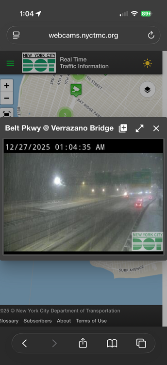
Brooklyn south shore getting crushed
-

Wounded Duck Strikes Back: Dec 26 & 27th Winter Storm Obs
dendrite replied to WxWatcher007's topic in New England
11.9° -SN 0.5” new -

Wounded Duck Strikes Back: Dec 26 & 27th Winter Storm Obs
Scott Koziara replied to WxWatcher007's topic in New England
We can never forget James and Messenger anytime it snows on The Cape! -
The snow just won't stop here my God.
-
I may have jumped the gun. Just went out there and it's about 3" and the heaviest of the night is coming down now and piling up quickly, hoping to get 4-5 out of it.
-
Not doing much of anything here, looks like this batch is favoring the south shore. I have maybe 4” now, haven’t measured.
-
I'm over 7 or 8 now my candy canes are nearly buried
-

Wounded Duck Strikes Back: Dec 26 & 27th Winter Storm Obs
Fozz replied to WxWatcher007's topic in New England
KFC is my favorite. Enjoy! -
Wait a minute,i remember this storm now.The LP came from Middle MS and rode trough Cen Alabama into Ga,this caused a deformation band into North Alabama,we just moved from Jacksonville to Lawrecrmburg.Tn,we got 8" from that storm
-

Wounded Duck Strikes Back: Dec 26 & 27th Winter Storm Obs
CCHurricane replied to WxWatcher007's topic in New England
Snowfall on Cape Cod
-
-
Sbout 3” and counting here in north Queens. Still coming down a bit too
-
we need the rain.
-
It is what it is. First heavy band was most of the storm so far.
-
So much of it is about expectations. Prior to the 14th there was so much concern about a cold/dry, warm/wet pattern and how it would never snow again. Then the area averaged over 6" on Dec. 14th, and before the first flake began to melt there was wailing about how the second half of December would be one big extended torchfest. Yet here we are again with plowable snow in much of the area. After it rains Sunday/Monday, looks like we're in the 30s at best the rest of the week. There's not a member here, especially at the coast, who wouldn't have in October happily signed up for how this December has gone.
-
Looks like a nice band forming across the area now
-
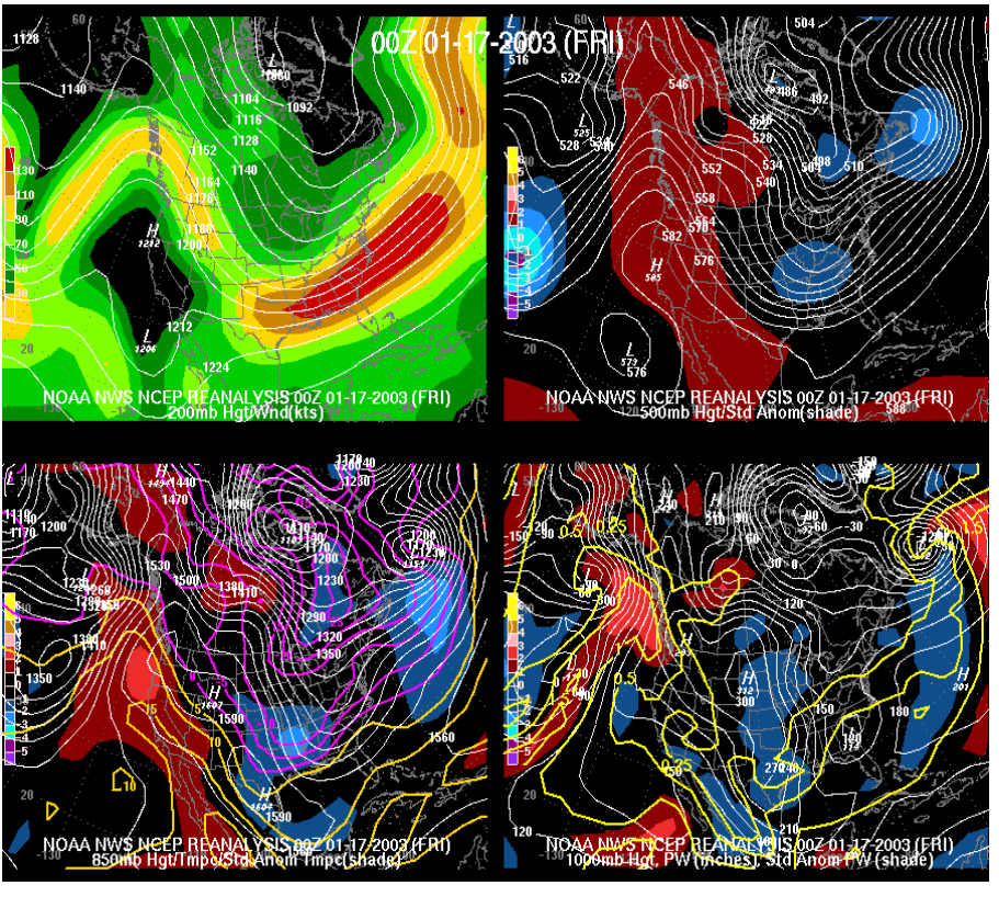
TBH,thats not a clipper by reanalysis
-
It was what you'd categorize as a Clipper/Miller B hybrid imo. Similar to the March '09 , I believe that bombed Memphis with nearly 10".
-
Driving around near Morristown... I don't think there's 2" of snow/sleet on the ground.