All Activity
- Past hour
-

White Christmas Miracle? December 23-24th
Sey-Mour Snow replied to Baroclinic Zone's topic in New England
LOL RRFS doesn't get accumulating snow into New England through 5pm Tuesday -

December 2025 Short/Medium Range Forecast Thread
Carvers Gap replied to John1122's topic in Tennessee Valley
Nice post. Interesting find by Golf. I keep an off-and-on eye on the coldest modeled mins for North America during the winter. I do that just to monitor how cold our cold source could be. The coldest I can find right now is low -60s. Now, that is pretty cold, but the record is -81 in the Yukon in 1947 according to a quick search. This is not for you, Jed. I know you know this. I am just trying to save a second post. Models have been having crazy amounts of feedback this winter. I think they are vastly overdoing certain features(Baja, NW Pac lows on repeat, western Canada cold?) which causes wild feedback all over the Western Hemisphere. I am not sure why this is happening. I don't know if there is a data ingest problem or programming has been changed/updated across models. Maybe they have a bug? But I have observed some pretty big errors. It reminds me of the 4' of snow forecast for Charlotte one year...and it never materialized. It was feedback which sometimes occurs to the SE of the southern tip of the Apps. Places on the map to watch for feedback...Baja, NW Pac, Aleutians(but not as bad as one would think IMHO), and Greenland. Now, the fun thing about that area of South Carolina which tends to feedback....sometimes it actually has extreme precip events. Think Helene. All of those other places have had extreme events...sometimes I think models go to that extreme due to those data sets. I would guess that Canada is going to be very, very cold this winter. That is a pretty easy guess as it already has been there this season. I think it finds its way south 1-2 times, and that will be plenty for most. Like you, I don't see even 100 year cold up there right now. But we'll see. Not everything is feedback though. I guess maybe the thing that concerns me some is that many of these cold fronts are getting much colder as we get closer to the event - that is kind of unusual. That might be a signal that the air mass up there is strong. We have good snowpack for it to move quickly. I would be more than thrilled to track an all-time great Arctic outbreak w/ lots of snow. I just don't know that we are gonna get much lead time on that... That said, I do think the strength of the cold is currently and is going to be in the future...a problem for modeling this winter. We have had some winters where we get a trough in the East, and there is only Canadian or weak polar air to fill it. This stuff is legit Arctic air. Let's not forget the SSW....we haven't had the cold dive to our side of the planet with that recently. But Russia and/or China have been hammered when that occurs. Sometimes, it does come to our side of the planet. Is this one of our years? Maybe, and there is some evidence to support that but just to early to know. edit: On an interesting note, my daytime highs for the past couple of months have sometimes been well under the point and click forecasts. I am ready for a few days of warm air. I keep waiting on some warm mornings! It was not warm this morning. -
Maybe I just missed it but I didn’t really expect snow today. Maybe half an inch?
-

Central PA Winter 25/26 Discussion and Obs
WmsptWx replied to MAG5035's topic in Upstate New York/Pennsylvania
CTP just posted on FB about Friday. That feels significant. -

December 2025 regional war/obs/disco thread
moneypitmike replied to Torch Tiger's topic in New England
It's sad to see what you've become. -
.thumb.png.4150b06c63a21f61052e47a612bf1818.png)
White Christmas Miracle? December 23-24th
HIPPYVALLEY replied to Baroclinic Zone's topic in New England
Hoping for 1” but this could end up mood flakes. -
 Well that was the difference between 1-2” and nothing. NYC in mid 30s right now, so shouldn’t expect anything except some white rain maybe. Marginal events like this would have likely worked in the past for a few inches. Not anymore
 -
Lots of overrunning snow to sleet to freezing rain
-

2025-2026 ENSO
40/70 Benchmark replied to 40/70 Benchmark's topic in Weather Forecasting and Discussion
You know when Larry lashes out, it's bad -
those off hour runs tend to do that it seems 6z, 12z show one thing, the others something else, weird trend I've noticed.
-
December 2025 regional war/obs/disco thread
40/70 Benchmark replied to Torch Tiger's topic in New England
I'd be surprised if the blocking trains strong enough to whiff us. -
18z gfs snowfall Sent from my SM-G998U using Tapatalk
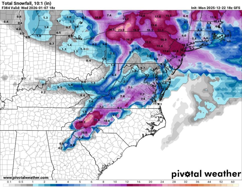
-
18z freezing rain map. Sent from my SM-G998U using Tapatalk
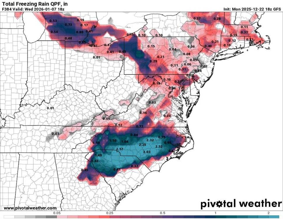
-
Let’s enjoy the cirrus together.
-

White Christmas Miracle? December 23-24th
CoastalWx replied to Baroclinic Zone's topic in New England
Let us know if that changes. -
White Christmas Miracle? December 23-24th
moneypitmike replied to Baroclinic Zone's topic in New England
3K still has it snowing still at 1:00p.m Wednesday in Maine. -
Historic 1,000 year cold building https://x.com/ryanmaue/status/2003182403121287452?s=46&t=m4Eqkekadb-JCXTm7k-Txg
-

White Christmas Miracle? December 23-24th
TauntonBlizzard2013 replied to Baroclinic Zone's topic in New England
16 years -
 Only an inch different? Wouldn’t call that a drastic shift in modeling
 -
White Christmas Miracle? December 23-24th
CoastalWx replied to Baroclinic Zone's topic in New England
Hopefully another Christmas that’s bare here and white on the Cape. That would be cool. -
I got you. I’m thinking more about the individual event; that year will never be replicated. .
-

White Christmas Miracle? December 23-24th
WinterWolf replied to Baroclinic Zone's topic in New England
Time to take another break again..see you in another 36 hrs. -

White Christmas Miracle? December 23-24th
Torch Tiger replied to Baroclinic Zone's topic in New England
Always looked marginal and very light. Mood snow is most likely -
White Christmas Miracle? December 23-24th
CoastalWx replied to Baroclinic Zone's topic in New England
It’s why I’m back. Just spreading holiday cheer. Busy today, but nothing worth posting about. -
White Christmas Miracle? December 23-24th
CoastalWx replied to Baroclinic Zone's topic in New England
Boundary layer is such garbage for a lot of us. If it were to pound dendies it might Be a different story, but this looks to have putrid rates at 33-34F outside of narrow bands. Just add it to the list of Smegma since 2022.


