All Activity
- Past hour
-
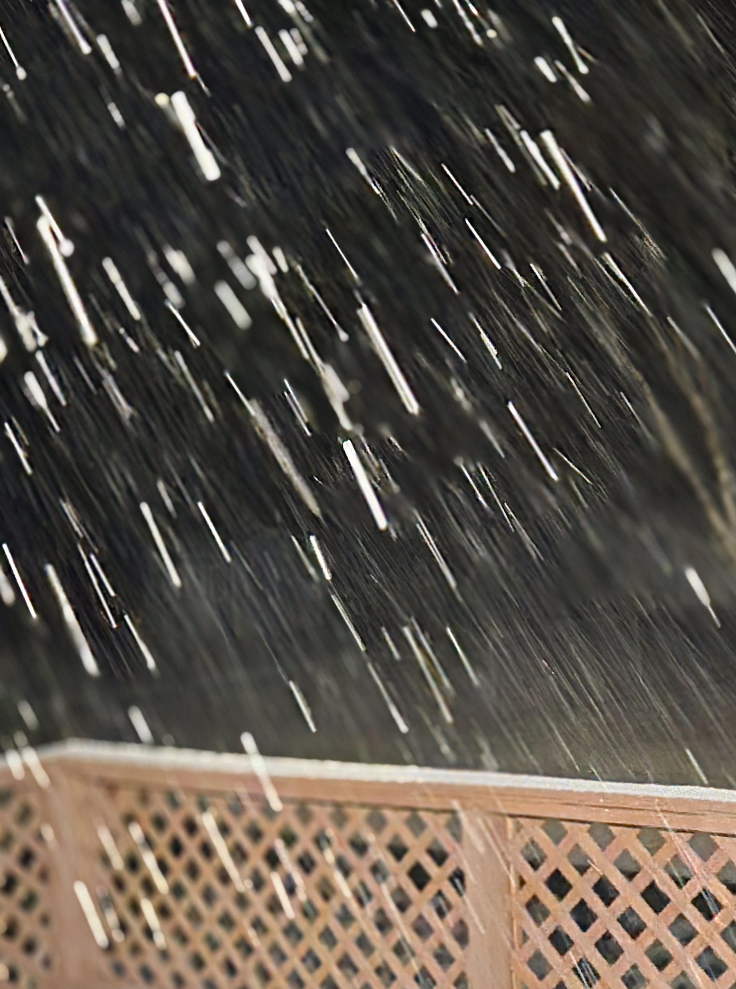
35 and rain. What a storm. This makes 3 WWA this winter and haven’t seen a flake yet! .
-
At least you are seeing snow falling. That is a win even if it's not sticking. Take it any way we can get it in the southeast. Glad you are seeing some snow.
-
35.8, everything is melting on contact but the flakes are getting fatter.
-
What's amazing is how a little elevation makes a difference. The city of danville is still mainly mix or rain and just north out here in the county its a beautiful Snow
-
36.5, snow and radar looking good. Will it stick? probably not.
-
Snowing hard here in Dry Fork after a Sleet/Rain mix for a while. Sticking quickly.
-
Down to 36.9 and picking up.
-
37.4 and wet snow. Thank you, cat for waking me up.
-

December 2025 regional war/obs/disco thread
powderfreak replied to Torch Tiger's topic in New England
3am and -6F. What a night. SLK at -20 already.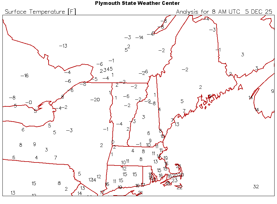
-
31/15. Partly to mostly waiting
- Today
-
38.7 and rain. So much for the snow.
-
Nothing will probably compare again to my morning classes at LSC in the dead of winter where the first physical sign of extreme cold was all the snot in my nose instantly freezing up after just stepping outside. I’m not keen on experiencing that again for as long as I’m around!
-
32/15, smells like snow out there.
-
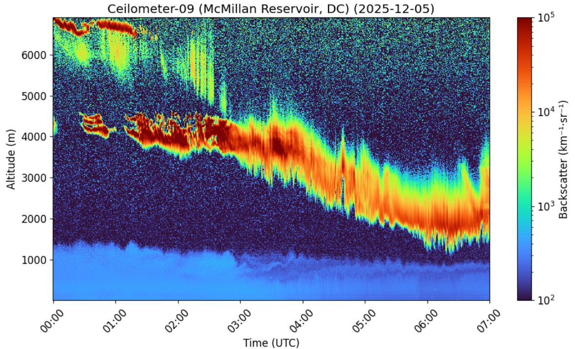
Woke up to check progress. Snow was getting steadily closer to the surface for the past 4 hours, but has stalled a bit in the last hour. It's trying to go through the really dry layer now.

-
Yes that was me. Skied standing up until March of 2022. Just too weak currently to ski standing up. Been doing adaptive skiing at Ski Sundown for 2 years. Did alot of skiing with my son. He's taken up skiing again and will be with me on December 27th.
-

Richmond Metro/Hampton Roads Area Discussion
eaglesin2011 replied to RIC Airport's topic in Mid Atlantic
Coming down nice & Steady now here in Short Pump -
Can’t complain no matter what. In this short time between posts it’s already cartopper and mulchtopper (pavement is still just wet though)
-
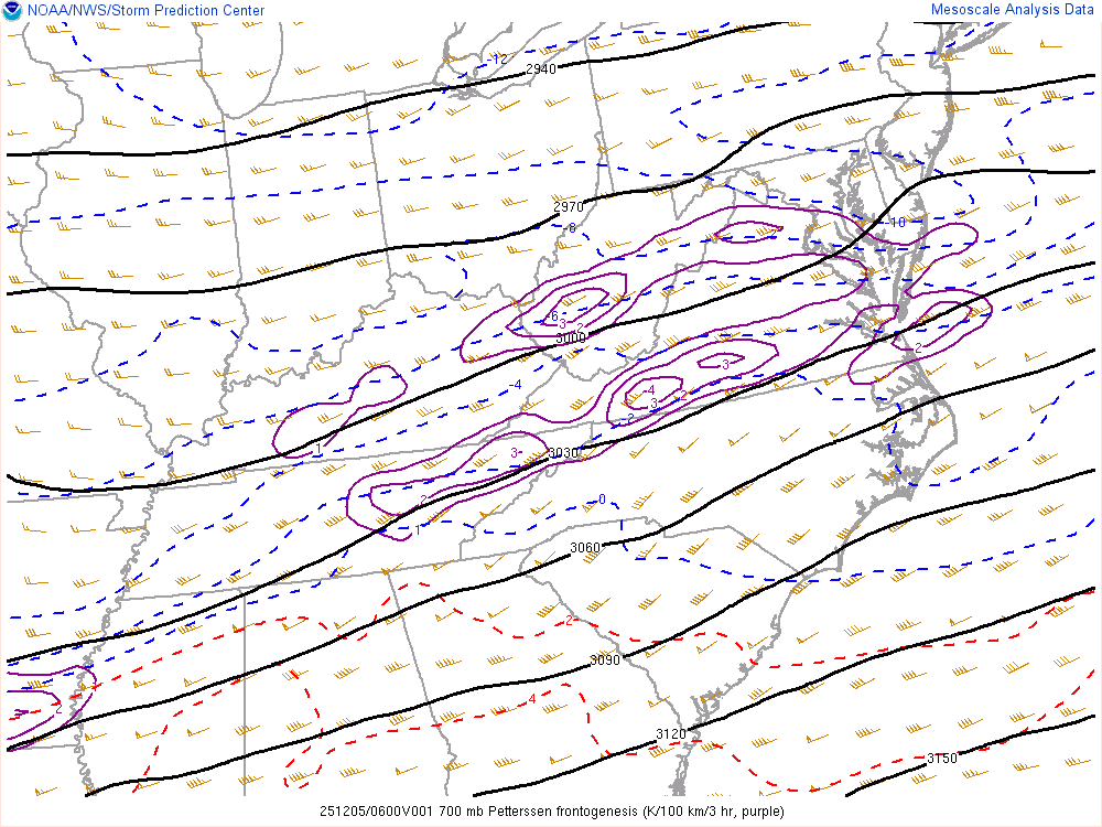
Wow 2nd northern band right over my old stomping grounds! I insist on the old HoCo/MoCo band. Look, it may not exactly be Snowmageddon up in here this round, but that band could easily boom them to 4 inches! Look at that -2, possibly even -3 FGEN! WOW is that a -4 over Penhook? Look out Bob Chill! If Dale City booms out to 4 inches, I'll do a stand in for Playboi Carti like I stated earlier tonight. I know most his raps by heart and worship all his tracks. Same for Ken Carson and Kodak Black. Someone is gonna jackpot up there!
-
Bingo. Unless you live in C/NNE or near lakes you're gonna get skunked. Coastal track is dead and gone...until spring of course
-
Light snow has started in Cvill a couple minutes ago. Snow flake size looks pretty good so far! FGEN seems to show two bands setting up (and skunking myself) but we’ll see what happens.
-
Almost to 1 inch.... Nice & peaceful looking outside...
-
Back to 1995-6, lowest SOI plunges -ENSO/lagged NYC wx -52 on 2/17/17: MB 3/10-18 and 9.7” -49 on 12/10/12: B 12/26-1/3 and 0.4” -47 on 12/19/95: MB 1/2-12 and 25” -47 on 2/2/13: B 2/7-10 and 11.4” -44 on 12/4/25 (due to strong compact Tahitian low) ??? -39 on 12/14/01: 12/30-1/2 MB/0” -34 on 1/19/17: 2/9-10 B/9.4” -31 on 11/7/22: 11/14-21 MB/0” The above tells me that IF there’s possibly any partial correlation of a strong -SOI during -ENSO to cold and/or snow at NYC, it’s not until 1-4 weeks afterward. A period of very heavy snow and/or MB temps occurred 1-4 weeks after 6 of the 7 sub -30 cases. This could easily just be random considering the small sample size and that this is pretty spread out (1-4 weeks afterward).
-
Same ole Great lakes tracks. It's cold/dry to warm/wet and back to cold dry. Horrible pattern for snow here. Maybe in January when storm track drops south we'll get something but this is a crappy pattern. Time to move to the lakes, tons of lake effect snows
-
39 degrees and nothing in York County.
-
Would rather have snow the last week of December rather then the first week - many times when it has snowed early in the month it warms up towards the end of the month and its mild with no snow on the ground Christmas week .........last year was considered to be a "White Christmas" believe it or not with the little snow that was on the ground in most areas of the immediate metro...........This year the falling SOI and the fading LaNina supported by MJO in phase 8 should activate the southern jet BUT all the players on the field have to align just right to produce a snowstorm here........also another Strat warming event is going to unfold the second half of the month so this pattern should extend well into January.............