All Activity
- Past hour
-
 The original idea of the heat this week coming in under June and July levels turned to be correct. This is what the models were originally showing before shifting to 102° heat in later runs. We haven’t had any 100° heat after August 12th since 1993. First/Last 100° Day Summary for NEWARK LIBERTY INTL AP, NJ Each section contains date and year of occurrence, value on that date. Click column heading to sort ascending, click again to sort descending. 1993 06-19 (1993) 102 09-03 (1993) 100 75 1953 06-21 (1953) 100 09-02 (1953) 105 72 1973 08-28 (1973) 100 08-28 (1973) 100 0 1948 08-26 (1948) 103 08-28 (1948) 102 1 2005 07-27 (2005) 101 08-13 (2005) 102 16 2002 07-04 (2002) 100 08-13 (2002) 100 39 1944 08-04 (1944) 100 08-13 (1944) 100 8 1949 07-03 (1949) 100 08-11 (1949) 102 38 2022 07-20 (2022) 100 08-09 (2022) 101 19 2001 08-07 (2001) 100 08-09 (2001) 105 1 2006 08-01 (2006) 100 08-03 (2006) 101 1 1955 07-05 (1955) 101 08-02 (1955) 100 27 2024 06-21 (2024) 100 08-01 (2024) 100 40
 -
looking for boston restaurant recommendations thx. seafood preferred
-
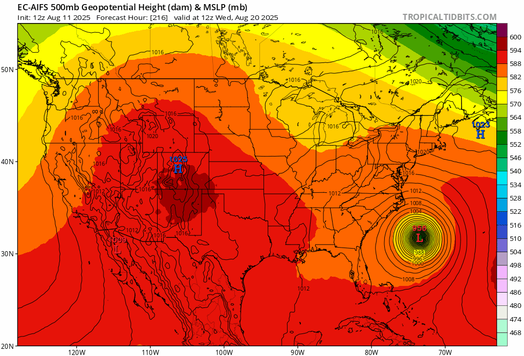
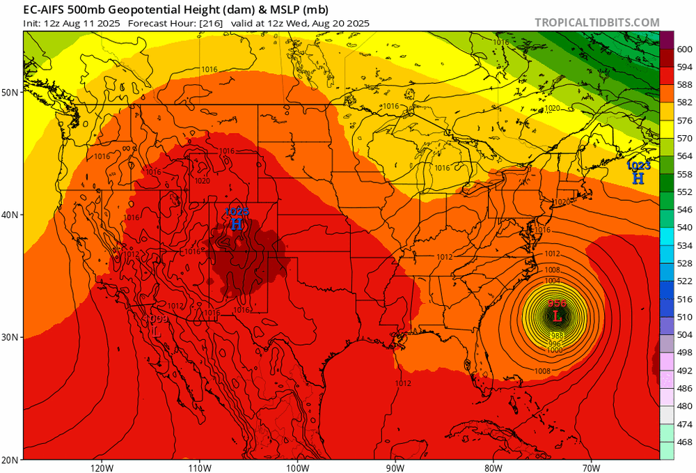
Not exactly... It's still a long shot but.... What you do need is for the longwave trough in eastern Canada to weaken...That's the "block" as it pertains to all of the east coast... On the euro AI all trends are in the right direction...weaker trough in eastern canada, stronger western atlantic ridge, and deeper shortwave over the Midwest.
-

Tropical Storm Erin - 45 mph - W @ 20
GaWx replied to BarryStantonGBP's topic in Tropical Headquarters
This will be a good test of Lezak and thus I feel it should be followed since you’ve been pushing him so hard. A potential positive thing I can say is that he may not be wishy washy. He said that a NC or SC hit is a likely target. I consider that an outright prediction even though he didn’t say it was a near certainty. Nothing can be a near certainty this far out. If it misses there, I’ll consider it a bust. If it were to hit there, I’d give him kudos for his prog. -
Congrats all. Late month continues to look coc’d:
-

Tropical Storm Erin - 45 mph - W @ 20
Diggiebot replied to BarryStantonGBP's topic in Tropical Headquarters
Same. I was 10. I went to bed at 4-5 pm so I could wake up when the storm hit in the overnight hours and not miss anything. When I woke up the news was saying how the storm took a last minute hard right….. -
 There are many variables that are involved. SSTAs could promote a tendency for ridging in various locations. Teleconnections could influence the positioning of such synoptic features. Rossby waves can also shape the development of the synoptic pattern.
 -
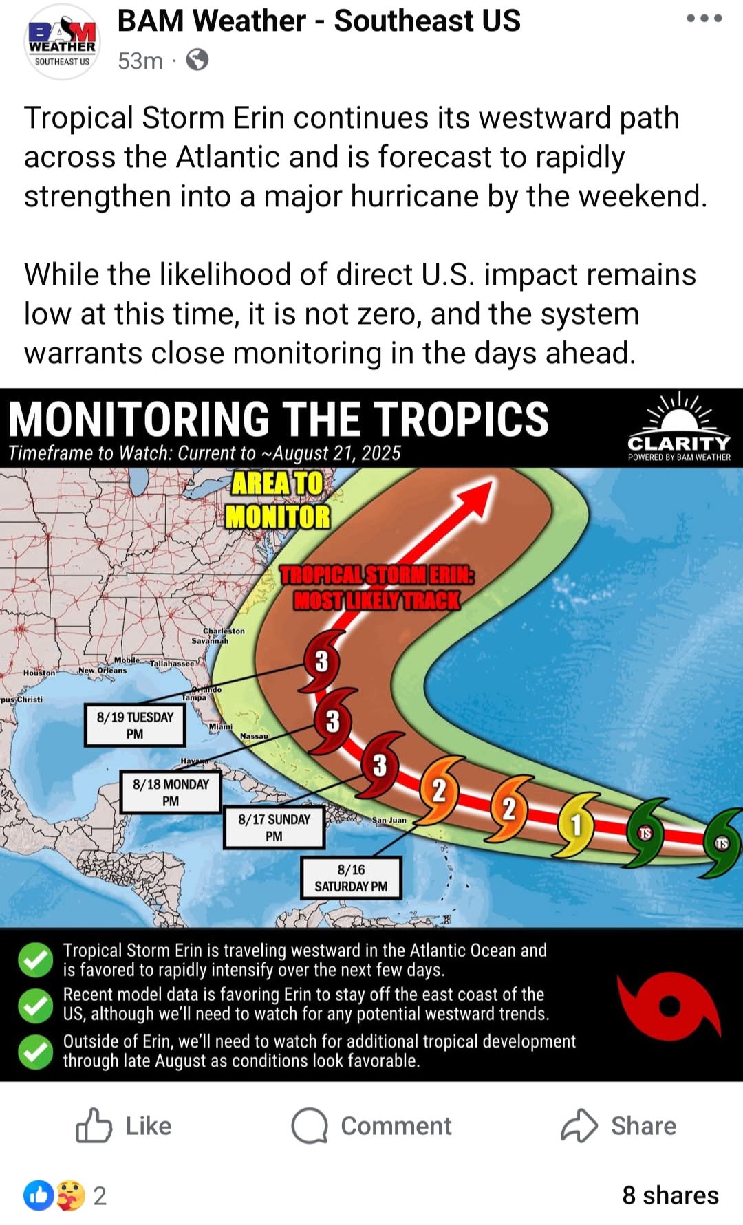
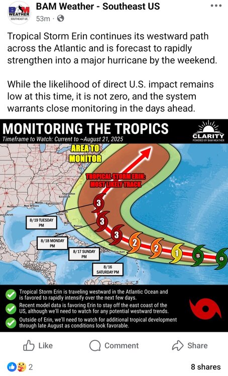
"Area to Monitor" thrown in there to get a few extra clicks. Love how it's placed on the Northeast..instead of Florida or the Gulf, which have more of a need to "monitor"
-
 83/75 today. very few thunderstorms this summer. Very boring weather overall
 -
I know that’s true…but my production the last decade makes it harder than ever to discern. I checked this morning and I have more sub 20” seasons than I do 30” seasons since 2018-19, and my average is 45-50”. I certainly have more failed epic winter patterns than failed fantasy canes. It’s exceptionally tough sledding for anything interesting lately. Tropical stuff aside I think most of us are frustrated by that. I have my annual peak season forecast due by the 20th, and I’m still not sure what direction I’ll take. I do think we’re looking at another backloaded season though given the continued SAL/stability issues I knew we’d have months ago. If September is warm with a WAR, we’re in the game. Otherwise, cutoff trough season in October and hybrids are probably our only shot at anything interesting.
-

Tropical Storm Erin - 45 mph - W @ 20
FPizz replied to BarryStantonGBP's topic in Tropical Headquarters
Can their cone could be a bit wider, lol -
lol
-
 I would be happy with anything honestly. So dry. Anything over 1/2" would be a gift.
 -

Tropical Storm Erin - 45 mph - W @ 20
BarryStantonGBP replied to BarryStantonGBP's topic in Tropical Headquarters
fat swells ahead for the EC innit lad -
I used to always get them at my old house under the south facing shutters. You could them scratching if you were inside the rooms with shutters. Plus I saw their poop on the ground.
-

-
Tropical Storm Erin - 45 mph - W @ 20
BarryStantonGBP replied to BarryStantonGBP's topic in Tropical Headquarters
fair play lads, but you’re testing the wrong thing nyc high temps to “debunk” the lrc is like checking the prem table by counting corners the lrc isn’t “day 41 = same temperature” it’s “the autumn pattern locks in, then the same set-ups (trough/ridge/block/jet kinks) keep rocking up on a ~40–60 day lap” you verify it at 500mb and with storm windows/corridors, not with a cvs receipt of max temps “self-made claims”? mate the method’s published, the cycle length wobbles, and nobody said it’s a metronome it’s a map for when/where to watch, not a magic dice roll for your postcode clickbait on x? agree, there’s plenty doesn’t mean pattern work = clickbait don’t bin the whole pub ‘cause one lad sang off key recurvature chat? sound. if there’s a fat canada trough carving a weakness, she’ll hook. lrc doesn’t fight the synoptics, it anticipates the window they turn up in tl;dr: lrc = dates + corridors from a recurring autumn blueprint verify with 500mb fingerprints & repeat setups, not surface highs cycle ≠ clock, it breathes (41ish this year ≠ tattoo) use it to spot the window, then let the guidance pick the lane now if you’ll excuse me cam on erin bam bam bam (score some over-water goals, lass) -

Tropical Storm Erin - 45 mph - W @ 20
MJO812 replied to BarryStantonGBP's topic in Tropical Headquarters
-
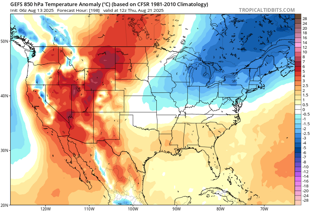
The Bermuda high has been shifting much further north during recent summers leading to more onshore flow here and record heat going to our north were the deep SW flow sets up.
-
Tropical Storm Erin - 45 mph - W @ 20
BarryStantonGBP replied to BarryStantonGBP's topic in Tropical Headquarters
GONZALO lad… all that hype, thought it was gonna smash us like ’87. Nan’s in Plymouth hoarding Rich Tea, neighbours lashing sandbags on the Co-Op door. Then it just peters out like some bargain-bin Dominican patio party. Plastic chairs blowin’ over in a breeze, reggaeton still blaring though there’s only two soggy blokes left dancing. -
Need a new roof before we go solar but yes it is in the pipeline. Heat pumps, new roof, and solar.
-
 Looks very hit and miss today. A few lucky spots could pick up an inch or two
-
Yes my roof orientation is wrong but we have mini panels for outside lighting and shedsqq
-
Yeah, this has been the theme during this decade with the PDO values rising into the winter and spring. https://www.ncei.noaa.gov/pub/data/cmb/ersst/v5/index/ersst.v5.pdo.dat Oct 2021….-3.13……..Mar 2022….-1.67 Jul 2022....-2.64…….Jan 2023…..-1.24 Sep 2023…-2.99…….Feb 2024…..-1.33 Oct 2024…..-3.80……Mar 2025…..-1.15
-
Tropical Storm Erin - 45 mph - W @ 20
BarryStantonGBP replied to BarryStantonGBP's topic in Tropical Headquarters
How did ed compare to lee