All Activity
- Past hour
-

July 2025 Obs/Disco ... possible historic month for heat
weatherwiz replied to Typhoon Tip's topic in New England
Think its safe to toss the HRRR -

July 2025 Discussion-OBS - seasonable summer variability
psv88 replied to wdrag's topic in New York City Metro
4:15 tee time today. Hope we can get the round in -

July 2025 Obs/Disco ... possible historic month for heat
Chrisrotary12 replied to Typhoon Tip's topic in New England
HRRR says YES! -

July 2025 Discussion-OBS - seasonable summer variability
Stormlover74 replied to wdrag's topic in New York City Metro
Should be later tonight if we get anything.thumb.png.f64d344dd4e4ce662055a7c1952cd4d1.png)
-

2025 Atlantic Hurricane Season
smokeybandit replied to BarryStantonGBP's topic in Tropical Headquarters
Now 60%. So glad I'm boarding a cruise ship today that'll be heading into that area next week. -
July 2025 Obs/Disco ... possible historic month for heat
weatherwiz replied to Typhoon Tip's topic in New England
This could also scale back the upper end of heat potential Monday -

Mountain West Discussion
donsutherland1 replied to mayjawintastawm's topic in Central/Western States
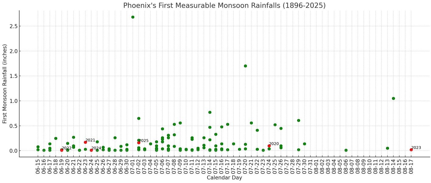
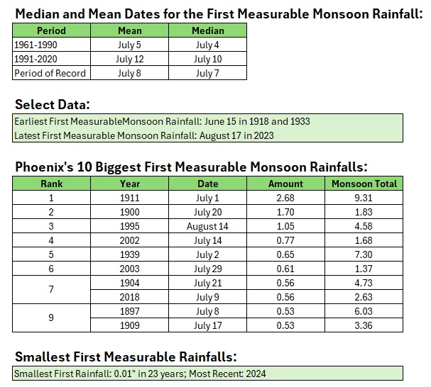
Yesterday, Phoenix saw its first measurable rainfall of Monsoon Season when 0.16” fell. It was the 35th biggest first measurable rainfall of Monsoon Season.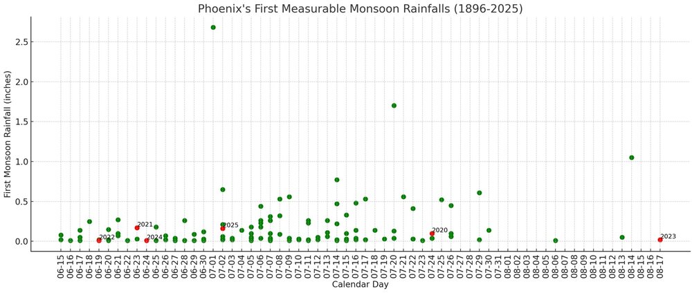
-
Spending Saturday, Sunday and Monday on the OBX. Euro says a washout with 1-3” of rain. GFS has scattered showers and less than 0.25” for the same period.
-

2025-2026 ENSO
Stormchaserchuck1 replied to 40/70 Benchmark's topic in Weather Forecasting and Discussion
Really some extreme QBO swings lately -
July 2025 Obs/Disco ... possible historic month for heat
weatherwiz replied to Typhoon Tip's topic in New England
HRRR seems wonky with the dews...wonder if thats why? -
Area of interest right off SE coast now has 60% development odds. Most models are on board with something coming together.
-

July 2025 Obs/Disco ... possible historic month for heat
RUNNAWAYICEBERG replied to Typhoon Tip's topic in New England
Not seeing it but good luck to another productive day for you. -
July 2025 Obs/Disco ... possible historic month for heat
Chrisrotary12 replied to Typhoon Tip's topic in New England
HRRR says NO! -
July 2025 Obs/Disco ... possible historic month for heat
Chrisrotary12 replied to Typhoon Tip's topic in New England
50/50 sounds good. -

E PA/NJ/DE Summer 2025 Obs/Discussion
JTA66 replied to Hurricane Agnes's topic in Philadelphia Region
Just tell yourself you’re storm chasing. Hearing my first cicadas this morning. -

July 2025 Discussion-OBS - seasonable summer variability
LongBeachSurfFreak replied to wdrag's topic in New York City Metro
Rare day where severe is less likely in central Jersey severe ally then north and east of the city. -
The 30 mb June QBO dipped to -13.72 from -4.59 in May. This is following most closely the 2014 progression and secondarily to 1972: https://psl.noaa.gov/data/correlation/qbo.data
-

July 2025 Discussion-OBS - seasonable summer variability
Sundog replied to wdrag's topic in New York City Metro
Surprisingly I got to 66 or 67 degrees last night. I was wondering how it got so cool in the house, I thought my wife forgot to turn off the AC lol. Then the Sun came up and my temperature jumped 10 degrees in one hour and now I'm 81 degrees. -

2025 Spring/Summer Mountain Thread
Met1985 replied to Maggie Valley Steve's topic in Southeastern States
Beautiful morning out with a low of 57. - Today
-

July 2025 Obs/Disco ... possible historic month for heat
dendrite replied to Typhoon Tip's topic in New England

-
July 2025 Obs/Disco ... possible historic month for heat
dendrite replied to Typhoon Tip's topic in New England
Min 61.4° Almost chilly! -
July 2025 Obs/Disco ... possible historic month for heat
weatherwiz replied to Typhoon Tip's topic in New England
Connecticut (particularly along and southeast of 84) and Rhode Island should be prime today -
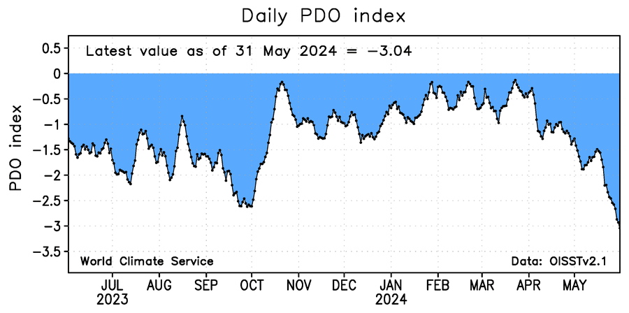
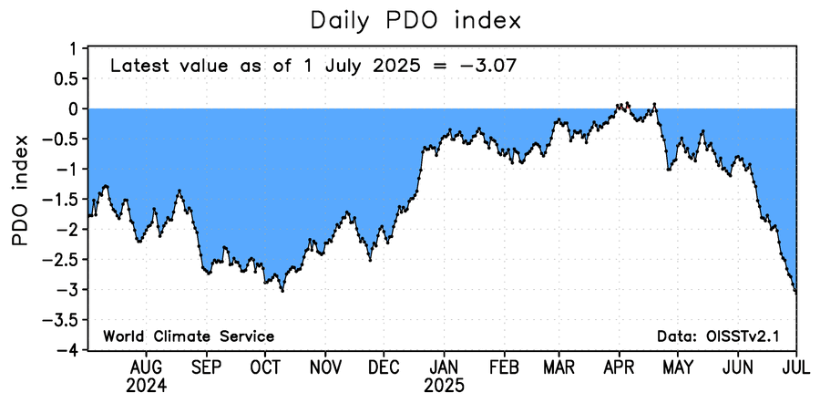
The WCS 7/1/25 PDO was all the way down to -3.07, the most negative WCS PDO day of any during the couple of years I’ve been following the WCS. This barely beats the -3.04 of 5/31/24 and the ~-3.02 of 10/10/24: Barring anything unexpected, this will likely bounce upward from near this level based on prior WCS dips stopping just below -3.
-

July 2025 Discussion-OBS - seasonable summer variability
SACRUS replied to wdrag's topic in New York City Metro
Records: Highs: EWR: 105 (1966) NYC: 103 (1966) LGA: 107 (1966) JFK: 104 (1966) Lows: EWR: 57 (1953) NYC: 54 (1933) LGA: 57 (1969) JFK: 56 (2001) Historical: 1873: A tornado in Hancock County, in far west central Illinois, destroyed several farms. From a distance, witnesses initially thought the tornado was smoke from a fire. A child was killed after being carried 500 yards; 10 other people were injured. 1933: Very cool 52° equaled the July minimum at DC; the "Dog Days" traditionally begin this day of the year. The hot weather period received its name from Sirius, the brightest visible star in the sky and known as the Dog Star. Sirius rises in the east at the same time as the sun this time of the year. (The Weather Channel) 1956: Lightning set off a dynamite charge near Brooksville, FL, killing one woman. (Ref. Wilson Wx. History) 1960: A major hail storm caused $1.5 million dollars in damage across the Denver, CO metro area. The heaviest damage occurred in south Denver, Englewood, Littleton and Golden from wind-driven hail as large as golf balls. Winds were estimated between 60 and 70 mph. Heavy rainfall was estimated at 2 to 3 inches. Hail carried flood waters drifted 3 to 4 feet deep. (Ref. Wilson Wx. History) 1966 - The northeastern U.S. was in the midst of a sweltering heat wave. The temperature at Philadelphia reached 104 degrees. Afternoon highs of 102 degrees at Hartford CT, 105 degrees at Allentown PA, and 107 degrees at LaGuardia Airport in New York City established all-time records for those two locations. (David Ludlum) (The Weather Channel) 1975: Up to 3 inches of rain caused flash flooding throughout Las Vegas, NV. The main damage occurred to vehicles at Caesars Palace with approximately 700 damaged or destroyed with several cars found miles away. North Las Vegas was hardest hit with $3.5 million in damage. Two people drowned in the flood waters. 1987 - Lightning struck and killed three men playing golf on a course near Kingsport TN. The three men had sought shelter from the rain under a tall tree on a small hill. Showers and thunderstorms produced heavy rain in New Jersey, with 5.2 inches reported at Trenton State College. (The National Weather Summary) 1988 - Thunderstorms around Fort Worth, TX, produced wind gusts to 76 mph at Burleson, along with two inches of rain in thirty minutes. The record low of 46 degrees at Youngstown OH was their sixth in a row. (The National Weather Summary)(Storm Data) 1989 - Showers and thunderstorms produced locally heavy rain in the eastern U.S. Bowling Green, KY, was soaked with 4.99 inches of rain during the morning hours, and up to ten inches of rain deluged Oconee County SC. The temperature at Alamosa, CO, soared to a record warm reading of 91 degrees, following a record low of 35 degrees the previous day. (The National Weather Summary) (Storm Data) -
July 2025 Discussion-OBS - seasonable summer variability
SACRUS replied to wdrag's topic in New York City Metro
76/ 69 clear. Great stretch of summery weather coming up, warm - hot today, mainly clear and dry - 80s - low 90s in the hotter areas. Passing storms tonight, look to stay mainly north and will make way for a gorgeous fourth of july - beach - bbq - bay - fireworks and outside dry- sunny warm mainly 80s / some 70s shores and north. Sat - mon - warm - hot / humid 80s to low/mid 90s in the hot areas - hottest looks monday - onshore component keeps heat focused inland. Beyond there overall warm - hot , humid and wetter - see onshore frequency. Way beyond continues to see ridge building heights east with heat following for a hot close.
.png.5779efae085a644de49c22a08b2fb777.png)