All Activity
- Past hour
-
Okay, okay, I'll install. Sheesh..
-
Had a streak of wet months since February here, so this month looks to continue the stretch. The last dry month was back in January.
-
Currently enjoying an R.S.H.C. stout from sapwood. Phenomenal. The habanero and chocolate blend is awesome.
-
5.5 back of the WC w/92 games left. If they can get to the break within 4 games, you never know.
-
great map
-
It looks like some rain is trying to develop south of DC. The sky has gotten much darker in the past hour. I wonder if that will move across the lowlands later. It's been a great day in the garden. Nice and cool with a little breezy drizzle.
-
Yuck. Didn't something eat all the leaves last year too?
-

2025 Atlantic Hurricane Season
BarryStantonGBP replied to BarryStantonGBP's topic in Tropical Headquarters
I'm grabbing my popcorn for humberto -
Tomorrow will be another cool day for the season. The temperature top out in the upper 60s to around 70°. It will be somewhat warmer on Tuesday with highs reaching the lower 70s. By Wednesday, the mercury will likely reach 80°. A sustained period of above normal temperatures will likely develop by midweek. No exceptional heat appears likely through the first three weeks of June. However, that could change shortly afterward if some of the extended range guidance is correct. The ENSO Region 1+2 anomaly was +0.4°C and the Region 3.4 anomaly was 0.0°C for the week centered around June 4. For the past six weeks, the ENSO Region 1+2 anomaly has averaged +0.23°C and the ENSO Region 3.4 anomaly has averaged -0.07°C. Neutral ENSO conditions will likely continue through at least mid summer. The SOI was -3.16 yesterday. The preliminary Arctic Oscillation (AO) was +0.402 today. Based on sensitivity analysis applied to the latest guidance, there is an implied 66% probability that New York City will have a warmer than normal June (1991-2020 normal). June will likely finish with a mean temperature near 73.3° (1.3° above normal).
- Today
-
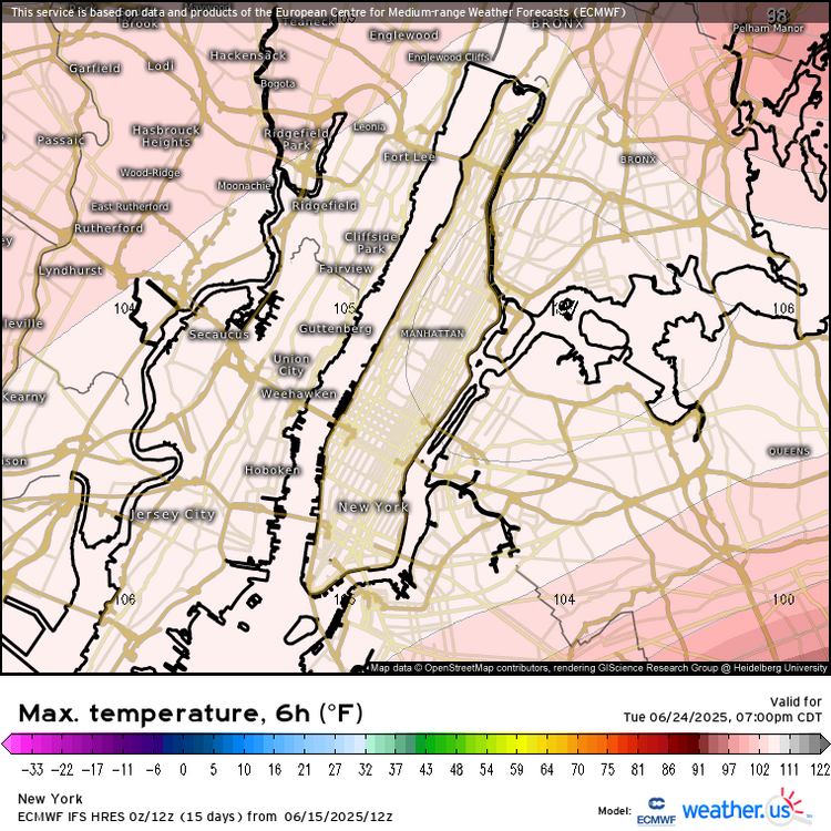
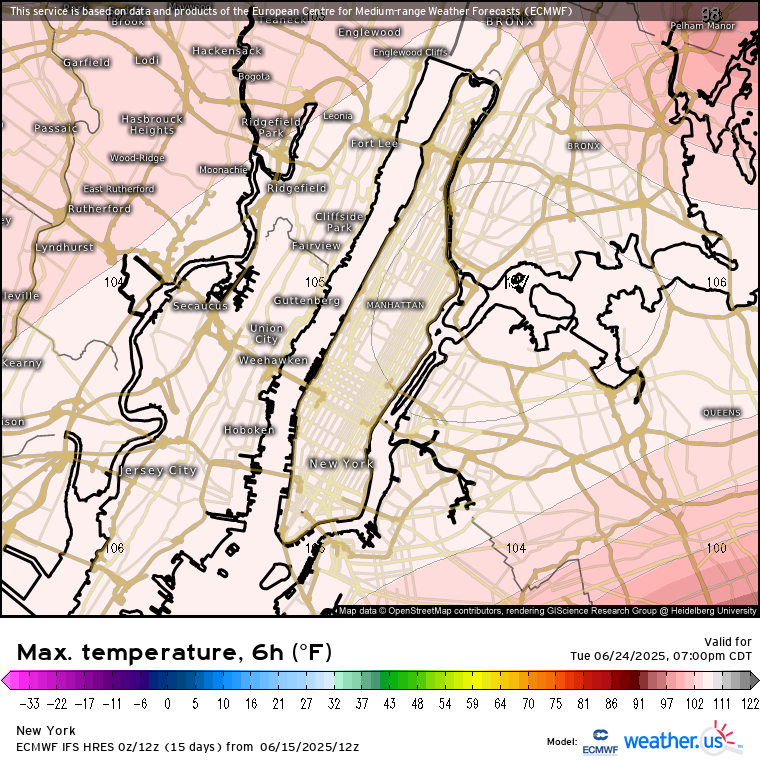
Congrats metfan. 107° NYC…LFG
-
Downright chilly out there!
-
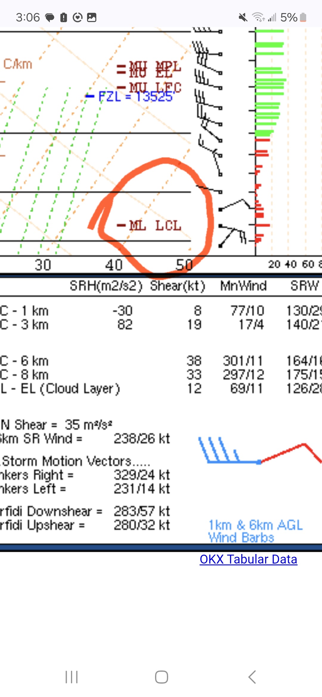
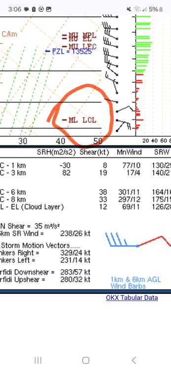
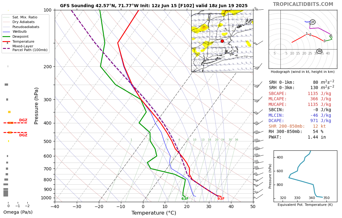
A cold front approaches New England Thursday afternoon/evening, this could trigger a severe weather risk. While we are looking five days out there is already an area highlighted to our southwest by SPC for the potential of severe storms. Quick look, there is instability to tap into, guidance has MUCAPE values above 2,000 J/kg, steep lapse rates including mid-level lapse rates of 7C/km, modest effective shear of ~35 knots. The machine-learning at CSU highlights much of the region with a 15% to 30% chance of severe weather, which is impressive this far out and will be something that needs to be watched.

-
Euro is hot. Oh baby.
-
Even Monday and Tuesday's chances are starting to fade. What went wrong?
-
CON avg min in July was 57° for 61-90. They had a July min in the 30s many years in the 70s.
-

2025-2026 ENSO
Stormchaserchuck1 replied to 40/70 Benchmark's topic in Weather Forecasting and Discussion
That is good agreement for an extended 5940dm ridge though.. in a continuous +AO pattern -
Light drizzle, 66. Feels like April.
-

2025 Short Range Severe Weather Discussion
Chinook replied to Chicago Storm's topic in Lakes/Ohio Valley
Day-2 30% hail (hatched) outlook for the Twin Cities -
-
When I lived at 1k in New Boston NH, 2012-18, the highest temp I ever saw on my Davis VP2 was 97.0 in 2012, on the hottest day of the year. First-order SNE sites were like 99-104 iirc
-
If we are talking KBOS or BDL it's really not difficult at all. 100F is a bit more challenging, and of course >100F is more rare. 98-99 is fairly routine for those spots. I suppose it's how you want to define "rare", too. lol
-
2025-2026 ENSO
Stormchaserchuck1 replied to 40/70 Benchmark's topic in Weather Forecasting and Discussion
And while we get ridging, these models are showing Summertime snow near Yellowstone! I haven't turned on my AC yet either -

2025-2026 ENSO
so_whats_happening replied to 40/70 Benchmark's topic in Weather Forecasting and Discussion
Sure just feel he likes to make sure his ducks are in order. No harm no foul. The WPAC is still warm but not excessively warm as it was so chipping away at it slowly is the name of the game. I would be interested to see if the WPAC starts to fire off any tropical systems coming up here with what could be a minor WWB coming up like we saw earlier this month still no typhoon but at least things are trying to get going. -
Sorry if you're already aware of this . I didn't stop by the forum yesterday, but for future reference, I would ask the guys at the MA thread . I have seen guys post forcast soundings from pivotal. The LcL should be already plotted and easily visible.


.thumb.jpg.6a4895b2a43f87359e4e7d04a6fa0d14.jpg)