All Activity
- Past hour
-

Southern Crippler - Get well soon Jimbo Storm Obs
DTP replied to BooneWX's topic in Southeastern States
Yessir- def a plus...seems like the higher up you are, the better the potential outcome once the wedge starts eroding- but I could def see wind being an issue up your direction bc of the gradient and the cold front later today I have a big 9000A Black Max that I normally use at my construction sites here jic -
Rates way better now, flakes look bigger too (from my apartment). Gonna go out in like 20-30 minutes I think.
-
I want those yellows

-

Southern Crippler - Get well soon Jimbo Storm Obs
Coach McGuirk replied to BooneWX's topic in Southeastern States
26.6 and freezing drizzle. I don't get to say that very often. -
Lol I remember in 2014 you going into great detail about that. I thought "what a weirdo. I found my tribe" lol
-

1/24-1/25 Major Winter Storm - S. IL, IN, and OH
KeenerWx replied to A-L-E-K's topic in Lakes/Ohio Valley
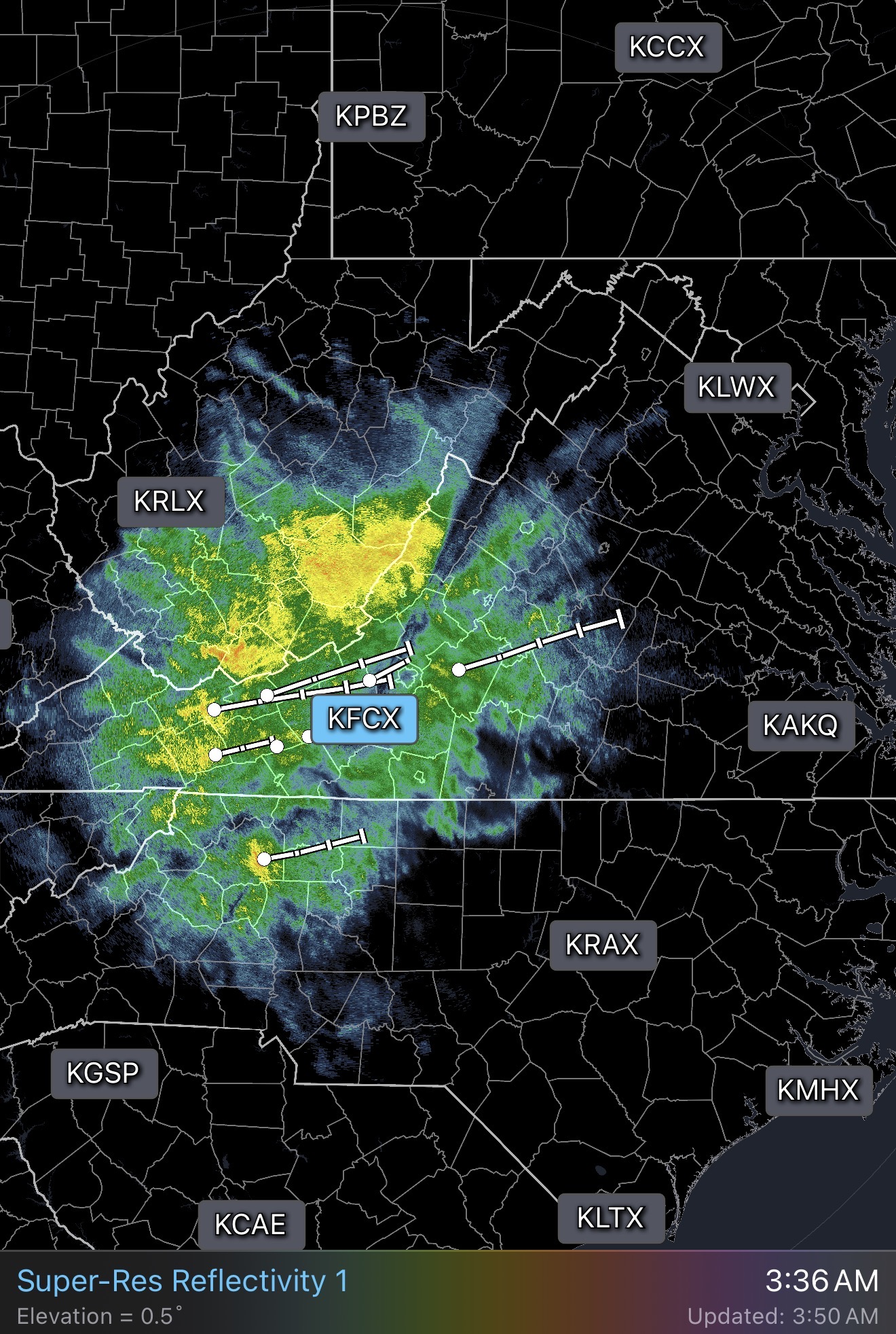
Approaching 3” here on the northern fringes. CAMs suggest possibly 3-5” left in the tank. Often performative and too aggressive, but cutting in half still results in a respectful 4-5” storm total. Became a bit too pessimistic given endless sawdust. -

Pittsburgh/Western PA WINTER ‘25/‘26
SteelCity87 replied to Burghblizz's topic in Upstate New York/Pennsylvania
That band has been hammering near Wexford and Cranberry. Wouldn't be shocked if they already have 3-4" -
It's slowing down. Look at it on radar. I think we rock for a few hours and stack.
-
EPS bumped up a good amount
-
Down to 14°. Mod snow, getting that fog look down the street
-
You think you were weird. In the old days I would wander around by streetlights holding a thermometer and a one foot ruler, taking numerous readings for hours and hours. I'd find a patch of ice and slide on it at high speed whooping it up like someone who's just won five billion dollars in the mega millions scratchoff. Man there is nothing, nothing at all, like the high high you can experience by seeing those big aggregates blowing by the streetlights, banshee northeasterly winds blowing snow along the ground, all while you walk slowly by while blasting your favorite track in your headphones!
-
Does anyone know how to get raw current data of our temps at all levels?
-

January 24-26: Miracle or Mirage OBS Thread!
LordBaltimore replied to Jebman's topic in Mid Atlantic
Very heavy rates for past 30 minutes or so. Predominantly spikes and plates, no huge individual flakes but plenty of aggregates -
Looking at CC doesn't look like the sleet line is racing like it was an hour or so ago. We still flip by like 8am prob in DC.
-
A true weenie just can't sleep! MEEEE 85F today with thunderstorms later. WEEEE
-
Those brights should be snow when it gets here
-
Latest hrrr is a weenie run but we know the sleet like always comes earlier
-

1/24-1/25 Major Winter Storm - S. IL, IN, and OH
buckeye replied to A-L-E-K's topic in Lakes/Ohio Valley
I’ll just say better than 50/50 we hit 12” -
Finally. We gotta stack the next 3-4 hours.
-
I’m over an inch. Trying to wait for heavier before i go out
-
17 degrees with sleet with Richmond, VA
-

January 25-26 Winter Storm Potential
KamuSnow replied to Ralph Wiggum's topic in Philadelphia Region
Light steady snow here, 17°F (down 1 degree since the snow began). A light dusting showing on driveway. Yay! -
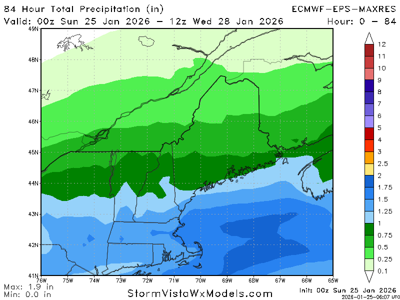
YES!!! Full on weenie mode now! Area Forecast Discussion National Weather Service Boston/Norton MA 246 AM EST Sun Jan 25 2026 .WHAT HAS CHANGED... - Trended snowfall totals higher for northeast MA, central MA high terrain, and the Berkshires
-
Meh…what time had sleet been predicted to enter the chat?
-
It looks like the sleet line is slowing down. It's hitting our wall of cold. Come on, wall of cold! Hold the line. We'll call her Eleanor. Eleanor, hold the line lol. Jebwalk joint just kicked in. I'm out. My neighbors are probably wondering why I'm not already out there wondering around under street lights like a weirdo.