All Activity
- Past hour
-
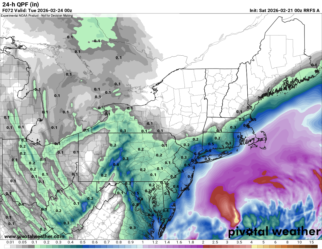
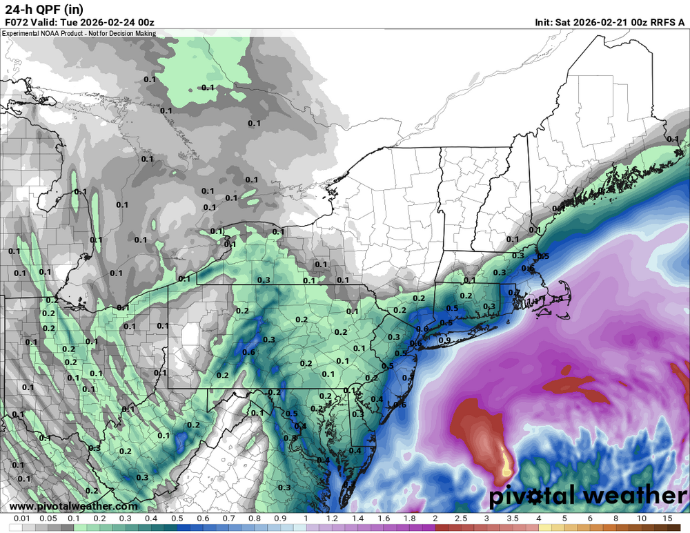
Did anyone post the 00z rufus?
-

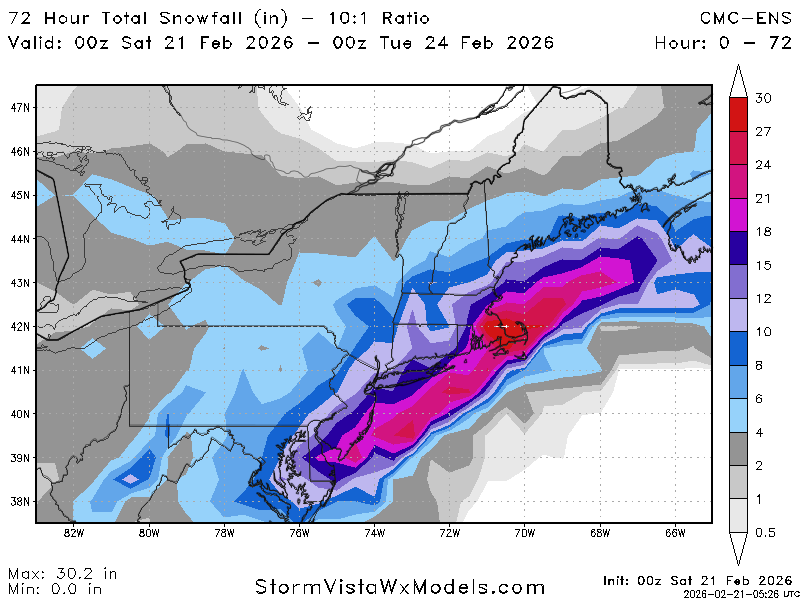
“Cory’s in NYC! Let’s HECS!” Feb. 22-24 Disco
ineedsnow replied to TheSnowman's topic in New England
Got a whole 3 hours of sleep last night -
Agree. It has pretty consistently been between the GFS and Euro. The current 00z track is still great. What I'm not sure about, and maybe someone has the answer here, is how well it performs with QPF. My understanding is that the AI models run at a lower resolution and have a tendency to smooth things out. Assuming that is true, I would seriously consider track and rely on mesos to work out the QPF.
-
Euro isn’t like how it was back in the day, not saying its wrong but something has to give.
-
The problem is, what if we get 18 - 24 inches of snow and the TV mets keep calling for 6-12 because one model refuses to budge?
-
Every single model keeps bumping west. The EURO holds serve. Either every single weather model is seeing something that the EURO isn't, or every single weather model is wrong and the EURO is right. We're 36 hours away.... something is up with the EURO imho.
-

Winter 2025-26 Medium/Long Range Discussion
cyclone77 replied to michsnowfreak's topic in Lakes/Ohio Valley
Hopefully the last half of March brings something meaningful. Until then looking zzzzz. -
This is true at all. It showed some good runs.
-
Nice bump west with cmc ensembles
-
I see tell-tale signs that GFS will win this battle. Moderate snow in Kansas is the signature of the phasing northern stream energy. The storm that tracked through southern UT-CO more or less died out as a dry weak circulation over nw TX and the primary low is developing further east now, around s AR, n/c MS into nw AL. If there's any model compromise it will be along the lines of 3:1 GFS:Euro. But it may be even better than that.
-
Agree
-

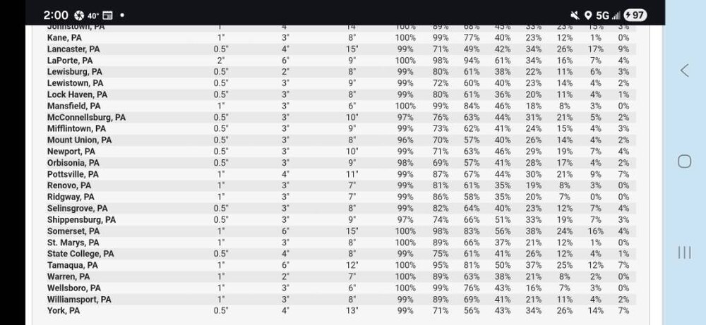
Central PA Winter 25/26 Discussion and Obs
Jns2183 replied to MAG5035's topic in Upstate New York/Pennsylvania
These ranges and probabilities are hilarious and great. I'm definitely not invested in this one. I'm solely rooting for inverted trough action. Those can be super sneaky good. Wasn't it in 2016 that one hit around Pittsburgh giving them double the forecast amount from hours prior? Sent from my SM-S731U using Tapatalk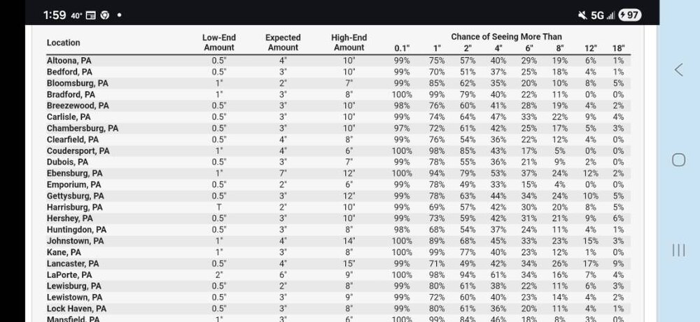
-

“Cory’s in NYC! Let’s HECS!” Feb. 22-24 Disco
40/70 Benchmark replied to TheSnowman's topic in New England
EPS is a couple of inches less....can't have it both ways...some of the same people calling east "trend" were the same people defining a trend as "3 consecutive runs" earlier today when everything was coming west. If this keeps up through 12z tomorrow, then time to panic. -
The Euro is an outlier but this is the reason why forecasters aren't jumping on the high end numbers quite yet because there's still time for this to trend east. It looks like a significant snow at the very least but I don't think a historic storm is a lock quite yet. I think 8-12+ is a good call right now
-
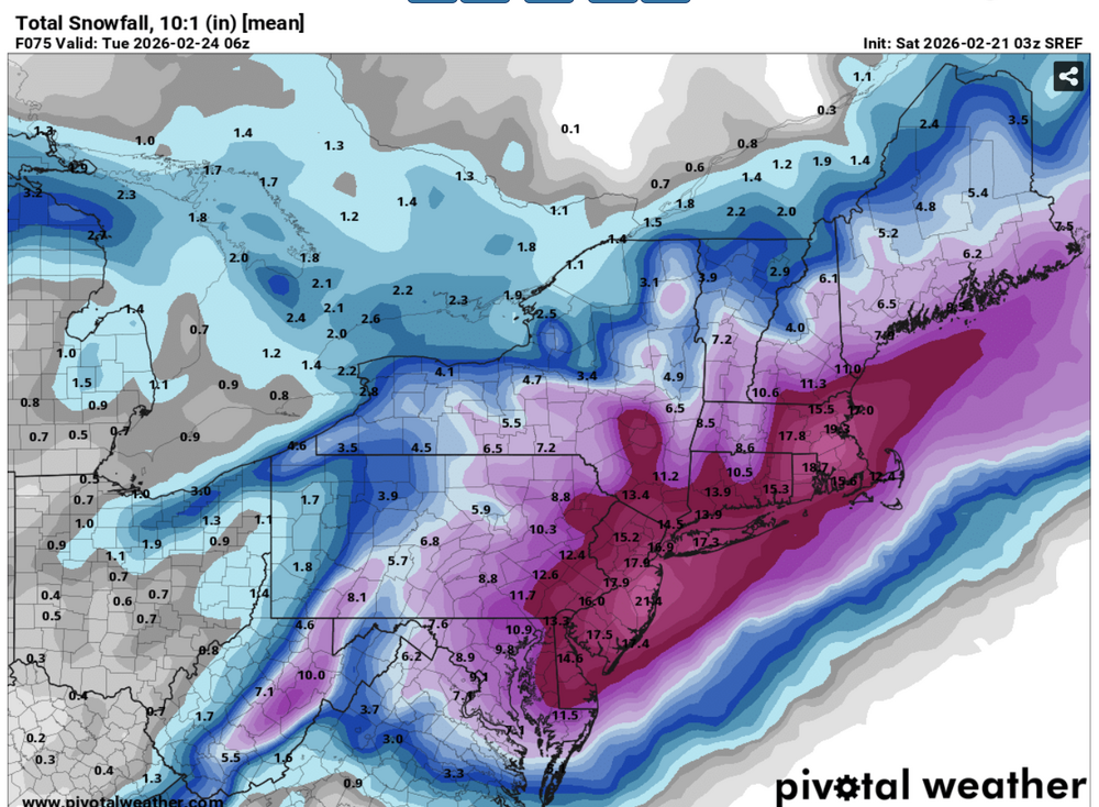
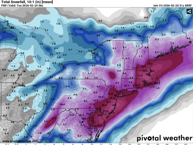
03z 21z On a positive note, SREF mean has improved.
-
“Cory’s in NYC! Let’s HECS!” Feb. 22-24 Disco
40/70 Benchmark replied to TheSnowman's topic in New England
I kind of think you're speaking from a NNE "outside looking in" perspective...SNE is getting smoked IMO....OP wobbles not withstanding. -
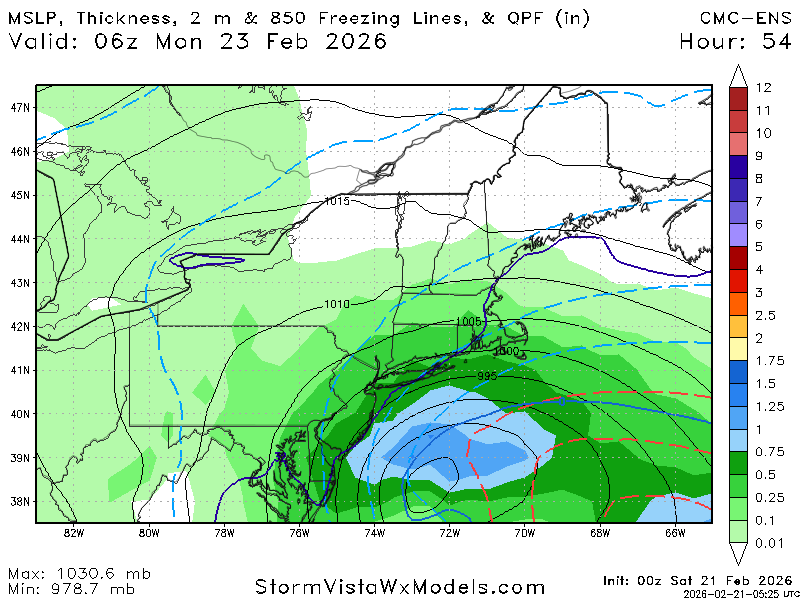
Also, the gfs has a lot more precip and higher pwat values ahead of the storm over the Carolinas, Va, and Ohio Valley. That helps lower surface pressures further northwest and favors a northwest track.
-

“Cory’s in NYC! Let’s HECS!” Feb. 22-24 Disco
weathafella replied to TheSnowman's topic in New England
You know, as sick as I am I decided to check in figuring you’d post something about the srefs. -
Yes I said earlier I'd like to see some non American model support for a HECS, since we didn't get it I think it's on the table but not necessarily a likely outcome. Still think mostly everyone in the subforum gets a foot barring a major last second east shift.
-
“Cory’s in NYC! Let’s HECS!” Feb. 22-24 Disco
ineedsnow replied to TheSnowman's topic in New England
3z Srefs look really good -
Hot off the presses… LWX pushes watches ever so slightly SW to include bay adjacent counties west of the bay and SE Howard. MOCO and DC left out still. URGENT - WINTER WEATHER MESSAGE National Weather Service Baltimore MD/Washington DC 146 AM EST Sat Feb 21 2026 MDZ014-017-018-506-211500- /O.EXA.KLWX.WS.A.0003.260222T2000Z-260223T1500Z/ Anne Arundel-St. Marys-Calvert-Central and Southeast Howard- 146 AM EST Sat Feb 21 2026 ...WINTER STORM WATCH IN EFFECT FROM SUNDAY AFTERNOON THROUGH MONDAY MORNING... * WHAT...Heavy snow possible. Total snow accumulations of 5 inches or more are possible. Winds could gust as high as 35 mph. * WHERE...Anne Arundel, Central and Southeast Howard, Calvert, and St. Marys Counties. * WHEN...From Sunday afternoon through Monday morning. * IMPACTS...Travel could be very difficult, especially Sunday night into Monday morning. The hazardous conditions could impact the Monday morning commute. PRECAUTIONARY/PREPAREDNESS ACTIONS... Monitor the latest forecasts for updates on this situation. && $$
-
Yeah, Boston area is probably 1-2 ft. It might be a little too warm at the onset though.
-
That’s fair. I think given trends there is a rather large “boom” scenario between NJ and Boston though, 20”+ somewhere the best band sets up
-
Not really icon and uk kinda back it up although not as extreme.
-
I've seen the NAM overamp storms a million times, but the GFS is usually suppressed or warm. Plus the UKMET, CMC and GEM are all with the GFS and NAM.